Balbharti Maharashtra State Board Class 6 Geography Solutions Chapter 5 Temperature Notes, Textbook Exercise Important Questions and Answers.
Maharashtra Board Class 6 Geography Solutions Chapter 5 Temperature
Class 6 Geography Chapter 5 Temperature Textbook Questions and Answers
A. Where am I?
Question 1.
The isotherm 0°C runs in my surroundings:
Answer:
Northern Asia/Northem Canada.
Question 2.
The mean annual temperature is 25°C around me:
Answer:
Central Africa.
![]()
Question 3.
The mean annual temperature around me is 10°C:
Answer:
Northern Europe/Central Asia/USA.
B. Who am I?
Question 1.
I connect places of equal temperature.
Answer:
Isotherm.
Question 2.
I am useful for measuring the correct temperature.
Answer:
Simple thermometer.
Question 3.
I get heated due to the land or water near me.
Answer:
Air.
Question 4.
Land and water gets heated due to me.
Answer:
Sunrays.
![]()
C. Answer the following:

Question 1.
Explain with a diagram, the effect of the spherical shape of the earth on the temperature at different latitudes.
Answer:
- Due to the spherical shape of the earth and the resultant curvature of the surface, sunrays occupy a larger or a lesser area.
- Equatorial regions which receive straight rays of the sun occupy less space and heat received is more.
- Polar regions receive slant rays of the sun occupy larger space but the heat received is less.
Question 2.
What is the relation between the latitudinal extent and temperature of a region?
Answer:
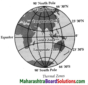
- 0° and 23° 30′ North and South perpendicular rays. Temperatures are higher throughout the year.
- 23° 30′ and 66° 30′ North and South receive extreme slant rays. Temperatures are moderate.
- 66° 30′ and 90° North and South receive extreme slant rays. Temperatures are very low.
Question 3.
What makes the isotherms run zigzag over continental areas?
Answer:
Isotherms run zigzag over continental areas because the temperature is influenced by its physical set up and height above the mean sea level on the continent.
![]()
Activity:
- Use the thermometer in your school and note the daily temperature on a display board.
- For two weeks, take down in your notebook, the information regarding weather given in the daily newspapers. Discuss your notes in the classroom.
Class 6 Geography Chapter 5 Temperature InText Questions and Answers
Can you tell?
Question 1.
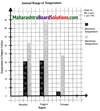
Find the range of temperature at Mumbai, Nagpur and Srinagar. Draw bar graphs for the same.
Answer:
Annual Range of temperature in °C
| Region | Min. temperature | Max. temperature |
| Mumbai | 20.5 | 32 |
| Nagpur | 22 | 44 |
| Srinagar | 2.5 | 24 |

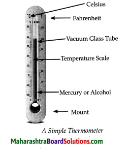
Answer the following questions with the help of figure:

Question 1.
What is the tube of the thermometer fixed on ?
Answer:
The tube of the thermometer is fixed on a mount.
![]()
Question 2.
What substance is used in the thermometer tube?
Answer:
Mercury or alcohol is used in the thermometer tube.
Question 3.
What do the figures on the scale indicate?
Answer:
The figures on the scale indicate temperature scale.
Question 4.
In which different units is the temperature measured?
Answer:
The temperature shows Celsius and Fahrenheit.
Question 5.
What season does the temperature in the figure indicate?
Answer:
The figure indicates summer season.
How will the rays fall between:
Question 1.
0° and 23° 30′ North and South?
Answer:
Perpendicular rays.
Question 2.
23° 30′ and 66° 30′ North and South?
Answer:
Slant rays.
Question 3.
66° 30′ and 90° North and South?
Answer:
Extreme slant rays.
![]()
What will you do?
You stay at ‘Man’ in Satara district. Your Grandma stays at Vengurla in Sindhudurg district. During Diwali, you often visit Vengurla. You like the sea coast there. The warm air of that region attracts you because you are freed from the dry air and scratching cold of your place. This time Grandma is suffering from asthma. Doctors have advised her to stay at a place which has a drier climate. What should you do?
Answer:
- Humid air is heavier than dry air, thus a person suffering from asthma finds it difficult to breathe in humid air.
- So, I will take my grandma to my place at Man’ in Satara district, as the air is dry in this region.
Think a little!
Question 1.
Will it be alright if water or oil is used in the thermometer?
Answer:
Water or oil cannot be used in a thermometer because they have a very high freezing part due to the lower temperature upto 30°C cannot be shown.
Question 2.
Where is the temperature of your district headquarters recorded?
Answer:
The temperature of the district headquarters is recorded in the district meteorological department.
Use your brain power!
Question 1.
Which season would be the best for visiting the following places and why? Goa, Chikhaldara, Chennai, Darjeeling, Ellora, Agra.
Answer:
Goa, Chennai, Ellora and Agra in the winter season. Chikhaldara and Darjeeling in the summer season.
Question 2.
Tell if the following statement is right or wrong. Give reasons.
In order to understand the climate of a region, the latitudinal extent is more useful than the longitudinal extent.
Answer:
The above statement is right.
In order to understand the climate of a region, the latitudinal extent is more useful because the earth is divided into three temperature zones depending on the amount of heat received from the equator to the North and South Poles.
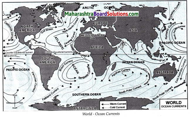
Observe the map. Name the coastal areas that will experience changes in temperature. Give the reason for this.

Answer:
(i) West coast of North America : The California current moving from the Northern frigid zone to the torrid zone will reduce the temperature at this coast.
(ii) East coast of North America : The Gulf stream current flowing towards the northern frigid zone will increase the temperature at this coast.
(iii) West coast of Europe : The North Atlantic current flowing towards the Northern frigid zone will increase the temperature at this coast
![]()
Class 6 Geography Chapter 5 Temperature Additional Important Questions and Answers
Fill in the blanks wish the right alternative given in the bracket:
Question 1.
The main factor which influences the distribution of temperature is ______. (ocean current, longitude, latitude)
Answer:
latitude
Question 2.
______gas can hold heat within itself in the atmosphere. (Carbon dioxide, Oxygen, Hydrogen)
Answer:
Carbon dioxide
Question 3.
Isotherms are fairly parallel to the latitudinal line in the _____ hemisphere. (Northern, Western, Southern)
Answer:
Southern
Question 4.
Nagpur receives _______ climate. (extreme, equable, moderate)
Answer:
extreme
Question 5.
When an ocean current flows from the frigid to the torrid zone, it _____ the temperature of the coast in the torrid zone. (increase, reduces, equal)
Answer:
reduces
Question 6.
Isotherms are lines that connect places with the ______ temperature after avoiding the effect of the height, (different, same, moderate)
Answer:
same
Question 7.
Substance used in a thermometer tube is _____ (water, mercury, oil)
Answer:
mercury
Question 8.
The freezing point of mercury is _______°C. (-39, -49, -59)
Answer:
-39
Question 9.
The freezing point of alcohol is _____ °C. (-110, -120, -130)
Answer:
-130
![]()
Question 10.
Air temperature is measured in _______ (Celsius, Fahrenheit, Grams)
Answer:
Celsius
Match the pairs correctly:
Question 1.
| Factor | Isoline |
| (1) Height | (a) Isotherm |
| (2) Temperature | (b) Isohyet |
| (3) Pressure | (c) Contour |
| (4) Rainfall | (d) Isobar |
| (5) Planktons | (e) Food for fishes |
| (f) Ocean current |
Answer:
1 – c
2 – a
3 – d
4 – b
5 – e
Give one word for the following sentences:
Question 1.
The sunrays which occupy less area.
Answer:
Perpendicular.
Question 2.
The sunrays which occupy larger area.
Answer:
Slant.
Question 3.
The climate in coastal areas.
Answer:
Equable.
![]()
Question 4.
The climate in continental areas.
Answer:
Extreme.
Question 5.
Food for fishes.
Answer:
Plankton.
Question 6.
Main factor responsible for influenceing the distribution of temperature.
Answer:
Latitude.
Question 7.
Measuring daily temperature.
Answer:
Thermometer.
Name the following:
Question 1.
Temperature zones on the earth:
Answer:
Torrid zone, temperate zone and frigid zone.
Question 2.
Lines drawn on a map by joining all the points having the same value:
Answer:
Isolines.
Question 3.
Two cold currents:
Answer:
Canaries and Peruvian current.
Question 4.
Two warm currents.:
Answer:
Equatorial and Brazil current.
![]()
Answer the following questions in one sentence each:
Question 1.
What is diurnal range of temperature?
Answer:
The difference in maximum and minimum temperature of a day is called diurnal range of temperature.
Question 2.
What factors leads to horizontal currents in the ocean?
Answer:
Horizontal currents develop in the ocean due
difference in temperature
density of water and
winds.
Question 3.
What is the advantage of the convergence of warm and cold current?
Answer:
The convergence of warm and cold current favours the growth of plankton.
Question 4.
What are isolines?
Answer:
Lines drawn on a map by joining all the points having the same value are called isolines.
Question 5.
Where is the distance between the isotherms parallel?
Answer:
The distance between the isotherms are parallel from South Pole to the Tropic of Capricorn.
Question 6.
Which factors lead to diversity in the climate of different regions?
Answer:
The factors which lead to diversity in the climate of different regions are nearness to the sea, continentality, height above the mean sea level and physical level.
Question 7.
What is an annual range of temperature?
Answer:
The difference in the mean temperatures of summer and winter is called an annual range of temperature.
![]()
Give geographical reasons for the following statements:
Question 1.
There is unequal distribution of heat received from the Sun.
Answer:
The unequal distribution of heat received from the Sun is because:
- The earth is spherical in shape.
- The rays which fall on the equator are straight, occupy less area and give more heat.
- The rays which fall on the curvature i.e., on the polar regions are slant rays which occupy large area and give less heat.
Question 2.
The temperature near the sea level is higher and it decreases in the mountainous region.
Answer:
- Firstly, the sea water gets heated by the rays of the sun.
- The absorbed heat is later radiated into the atmosphere.
- So, the layer of air close to the surface gets heated.
- This heat gets transferred vertically to the adjacent upper layers of air.
- Therefore, the temperature near the sea level is higher and it decreases at the mountainous region.
Question 3.
In the coastal areas, as compared to continental areas, the temperature of air is lower during the day but warmer at night.
Answer:
- There is difference in the heating and cooling of land and water.
- The air over the land gets heated faster and also cools rapidly.
- The air over the water gets heated slowly and also loses the heat in a slower manner.
- The temperature of air is lower during the day but warmer at night, in the coastal areas when compared to continental areas.
![]()
Question 4.
Greenhouse gases lead to increasing temperature of the earth.
Answer:
- Some gases in the atmosphere like carbon dioxide and water vapour can hold the heat within themselves for a long period of time.
- Due to the gases, the temperature of air in the atmosphere increases.
- Thus, greenhouse gases lead to increasing temperature of the earth.
Question 5.
Regions, where warm and cold currents converge, are favourable for the growth of fisheries.
Answer:
- Regions, where warm and cold currents converge, are favourable for the growth of planktons.
- Planktons are the food for fishes.
- Fishes travel here in large numbers.
- They breed in warm waters and increase the number of fishes.
- Therefore, regions where warm and cold currents converge favour the growth of fisheries.
Answer the following questions in short:
Question 1.
Explain the movement of ocean currents from equator to the polar region.
Answer:
Due to temperature differences, both upward and horizontal currents develop in the ocean. Besides temperature differences, factors like winds and differences in the density of water also give rise to horizontal currents. These ocean currents flow from the equator to the polar region and from the polar region to the equator.
Question 2.
Explain the effect of the ocean current flows from the frigid to the torrid zone.
Answer:
When an ocean current flows from the frigid to the torrid zone, it reduces the temperature of the coasts in the torrid zone. When a current flows from the torrid to the frigid zone, it increases the temperature of the coasts in the frigid zone.
![]()
I can do this!
Question 1.
Identify the temperature zones.
Answer:
There are three temperature zones namely torrid, temperate and frigid zones.
Question 2.
Tell the factors influencing temperature.
Answer:
Factors influencing temperature are latitude, winds, nearness to the sea, continentality, vegetation cover, cloud cover, physical set up, height above sea level and industrialisation.
Question 3.
Describe the global distribution of temperature with its characteristics.
Answer:
The isotherms in the southern hemisphere are fairly parallel to the latitudinal lines. From South Pole to the Tropic of Capricorn the distance between these lines is almost equal. As the proportion of land in the southern hemisphere is limited, temperatures in these parts are largely influenced by latitude.
In the northern hemisphere, the distance between these lines varies. In this hemisphere, the proportion of land is comparatively greater. This affects the distribution of temperature. These effects are seen in the form of variations in the distance between the isotherms and curved nature of these lines.
Question 4.
Describe the structure of a thermometer.
Answer:
A vacuum glass tube is filled with mercury or alcohol is mounted on a wooden board. There are two temperature scales showing Celsius and Fahrenheit.