Maharashtra Board Class 9 Geography Solutions Chapter 2 Endogenetic Movements

Balbharti Maharashtra State Board Class 9 Geography Solutions Chapter 2 Endogenetic Movements Notes, Textbook Exercise Important Questions and Answers.

Maharashtra State Board Class 9 Geography Solutions Chapter 2 Endogenetic Movements

Class 9 Geography Chapter 2 Endogenetic Movements Textbook Questions and Answers

1. Tick in front of the correct option ✓

(a) On which of the following are slow movements in the earth’s interior dependent?
Landforms [ ]
Velocity [ ]
Direction [ ]
Answer:
Velocity

Maharashtra Board Class 9 Geography Solutions Chapter 2 Endogenetic Movements

(b) When waves divert from each other, what do they create
Compression [ ]
Tension [ ]
Mountain [ ]
Answer:
Tension

(c) For the formation of a rift valley, which of the following processes should occur in the earth’s crust?
Compression [ ]
Tension [ ]
Weathering [ ]
Answer:
Tension

(d) Which of these is a fold mountain?
The Satpudas [ ]
The Himalayas [ ]
The Western Ghats [ ]
Answer:
The Himalayas

(e) The formation of extensive plateaus is a result of which type of movements?
Mountain-building [ ]
Continent-building [ ]
Horizontal [ ]
Answer:
Continent-building

2. Give geographical reasons.

(a) Buildings collapsed at the foothills of the Himalayas because of an earthquake. Before collapsing they were moving forward and backward.
Answer:

  • The seismic waves can be divided into primary, secondary and surface waves.
  • The primary waves are the first ones to reach the surface of the earth after the energy is emitted in the Earth’s interior.
  • Subjected to a ‘P’ wave, particles in the rock move in the direction of waves to and fro and therefore, these waves are also called forward-backward waves. Maharashtra Board Class 9 Geography Solutions Chapter 2 Endogenetic Movements
  • Thus, during an earthquake, the buildings at the foothills of the Himalayas moved forward and backward as they were first subjected to “P” waves.

(b) There is a difference in the formation of the Meghalaya Plateau and the Deccan Plateau.
Answer:

  1. The Meghalaya plateau is formed due to slow movements (orogenic movements) whereas the Deccan Plateau is formed due to sudden movements (fissure volcano).
  2. During the formation of the Meghalaya plateau, a part of the Earth’s crust in between two parallel faults was lifted forming a plateau whereas, the Deccan plateau was formed due to molten material coming out with the eruption spreading on both sides of the fissure.
  3. Thus, there is a difference in the formation of the Meghalaya plateau and the Deccan plateau.

(c) Most of the volcanoes are found on the plate boundaries.
Answer:

  • The plate boundaries are directly related to the areas of volcanoes.
  • Most of the volcanoes are located on the plate boundaries.
  • The part of the plate boundary which slides under the crust, results in the loss of material. Such boundaries are called plate consuming boundaries.
  • In areas where new material (magma) is coming up onto the Earth’s crust, they are called plate creating boundaries.
  • Both the processes result in earthquakes and volcanoes. Thus, most of the volcanoes are formed in the plate boundaries.

(d) The Barren Island is becoming conical in shape.
Answer:

  • Barren island which was considered a dormant volcano has become active since February 2017.
  • Mainly dust, smoke and mud are coming out of this eruption along with some lava.
  • During eruption, the lava is spread around the mouth of this vent, when it comes out.
  • As a result, a cone-shaped mountain starts forming. Maharashtra Board Class 9 Geography Solutions Chapter 2 Endogenetic Movements

Therefore Barren Island is becoming conical in shape.

(e) Volcanic eruptions can cause earthquakes.
Answer:

  • Generally, the movements in the Earth’s interior occur in the upper layer of the mantle
  • Tremendous energy is released by radioactive materials present here.
  • This leads to a sudden movement in form of volcanic eruptions where hot solid, liquid and gaseous materials are forcefully thrown out from the mantle of the Earth, onto the surface of the Earth.
  • This causes a lot of instability within the crust of the Earth which would also lead to the release of pressure in the form of seismic waves or tremors causing earthquakes.

3. Identify and name the internal movement.

(a) Tsunamis are generated in coastal areas.
Answer:
Sudden Movement

(b) The Himalayas are an example of fold mountains.
Answer:
Slow movement – Mountain Building Movements.

(c) Molten magma is thrown out of the earth’s mantle.
Answer:
Sudden Movement

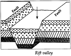
(d) Rift valley is formed because of faulting.
Answer:
The slow movement – Upward – Downward Movement.

4. Arrange the following statements in chronological order in which an earthquake occurs.

(a) The earth’s surface vibrates
Answer:
The plates suddenly move.

(b) The plates suddenly move.
Answer:
Due to the movements in the mantle compression goes on increasing.

(c) Due to the movements in the mantle, compression goes on increasing.
Answer:
Along the weak point (faultlines) rocks break apart.

(d) Along the weak points ( faultlines) rocks break apart.
Answer:
Stored energy is released in the form of seismic waves.

Maharashtra Board Class 9 Geography Solutions Chapter 2 Endogenetic Movements

(e) Stored energy is released in the form of seismic waves.
Answer:
The earth’s surface vibrates.

5. Distinguish between

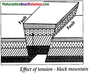
(a) Block Mountain and Fold Mountain
Answer:

Block MountainFold Mountain
(i) When a part of the earth’s crust between two parallel faults is lifted a block mountain is formed.(i) Because of the energy waves and pressure working towards each other, the layers of the soft rocks form folds leading to the formation of fold mountains.
(ii) Block mountains are formed due to tension.(ii) Fold mountains are formed due to compression.
(iii) e.g. The Black forest mountains of Europe and the Meghalaya Plateau of India.(iii) e.g. The Himalayas, the Aravalis, the Rockies, the Andes, the Alps

(b) Primary and Secondary Seismic Waves
Answer:

Primary Seismic WavesSecondary Seismic waves
(i) Primary waves are the first one to reach the surface of the earth after the energy is emitted in the Earth’s interior.(i) The waves which reach the Earth’s surface after the primary waves are called secondary waves.
(ii) Primary waves can travel through solid, liquid and gaseous medium.(ii) Secondary waves can travel only through only solid medium.
(iii) While travelling through liquid medium, primary waves change their direction.(iii) Secondary waves get absorbed as they enter the liquid medium.
(iv) The waves move to and fro in the direction of energy transfer.(iv) These waves move up and down in the direction of energy transfer.

(c) Earthquakes and volcanoes
Answer:

EarthquakesVolcanoes
(i) Earthquake is the movement of the Earth’s crust.A volcano is an opening in the Earth’s crust from which hot solid, liquid and gaseous materials are thrown out from the mantle of.
(ii) Nothing is ejected out during an earthquake.During a volcanic eruption, ash, water vapor, various types of poisonous and inflammable gases, hot molten magma etc. is ejected from the earth’s interior.

6. Answer in brief
(a) Give reasons why an earthquake occurs.
Answer:

  • When the movements occur in the interior of the Earth, tremendous tension is created in the Earth’s crust.
  • When the tension goes beyond limits, the energy is released in the form of waves.
  • This results in the trembling of the earth’s surface, i.e. an earthquake occurs.

Maharashtra Board Class 9 Geography Solutions Chapter 2 Endogenetic Movements

Following are the reasons for the occurrence of an earthquake:

  • Moving of the plates
  • Colliding of the plates
  • Plates sliding one below the other
  • Forming of fractures in rock layers, due to tension in the interior of the Earth.
  • Occurring of volcanic eruption

(b) Which type of movements have led to the formation of the major fold mountains in the world?
Answer:

  • Fold mountains are formed due to mountain-building (erogenic) movements.
  • Energy is transferred from the interior of the Earth. Because of these energy waves and pressure working towards each other and in horizontal direction, the layers of the soft rocks form folds.
  • If the pressure is very high, large scale folds are formed and their complexity increases.
  • As a result, the surface of the Earth gets uplifted and fold mountains are formed.
  • The Himalayas, the Aravalis, the Rockies, the Andes, the Alps are the major fold mountains of the world.

(c) How is the magnitude of the earthquake-related to the collapse of houses
Answer:

  • Through a seismogram, a graph showing movement of seismic waves (seismograph) can be generated.
  • After studying this graph, the magnitude of the earthquake is known.
  • The magnitude of the earthquake is measured with the help of a richter scale.
  • It is because of the primary waves that the buildings on the Earth’s surface move back and forth.
  • The buildings on the Earth’s surface move up and down because of the secondary waves. These are more destructive than the T’ waves leading to collapse of buildings.

(d) What are the effects of earthquakes on the earth’s surface and human life?
Answer:
Following are the effects of earthquakes:

  • Cracks/fractures develop on the ground.
  • These causes landslides which leads to sliding of rocks.
  • Sometimes the groundwater changes its course. For example, wells may get water, or may dry up.
  • Some areas get uplifted while some may subside.
  • Tsunamis are generated in oceans These waves can cause great loss of life and property in the coastal areas.
  • In snow-covered areas, avalanches may occur.
  • Buildings collapse and loss of life and property occurs.
  • Transportation routes get disrupted.
  • The communication system collapses.

(e) Explain the types of seismic waves.
Answer:
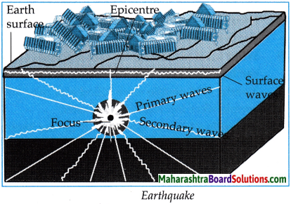
When the intension is released at the focus, the released energy travels in all directions. This energy comes towards the Earth’s surface in the form of waves. The seismic waves can be divided into primary, secondary and surface waves.
(i) Primary or ‘P’ waves:

  • These waves are first to reach the surface of the Earth, after the energy is emitted in the Earth’s interior. They travel at a very fast speed from the focus of the earthquake in radial direction.
  • The waves moves to and fro, therefore these waves are called forward-backward waves.
  • These waves can travel through all the three states – liquid, solid and gaseous.
  • While travelling through liquid medium, their direction gets changed. It is because of the primary waves that the buildings on the Earth’s surface move back and forth.

Maharashtra Board Class 9 Geography Solutions Chapter 2 Endogenetic Movements

(ii) Secondary or ‘S’ waves :

  • The waves which reach the Earth’s surface after I the primary waves are called secondary waves. :
  • These waves also scatter in all directions from the focus of the earthquake.
  • Their velocity is less than ’P’ waves.
  • The particles lying in the way of these waves j move up and down in the direction of energy transfer.
  • These waves can travel only through the solid medium and they get absorbed as they enter the liquid medium.
  • The buildings on the Earth’s surface move up and down because of these waves. These are more destructive than ‘P waves.

(iii) Surface or ‘L’ waves :

  • These waves are generated after the main ’P’ and ‘S’ waves reach the epicenter.
  • They travel in the direction of the circumference of the Earth, along the crust and are highly destructive.

(f) Explain the types of volcanoes on the basis of the periodicity of eruption with examples.
Answer:
According to the periodicity of the volcanic eruptions, three types of volcanoes can be identified.
(i) Active Volcanoes –

  • If the volcanic eruptions are regular even in the present times, then such volcanoes are called active volcanoes.
  • E.g., Mt Fujiyama in Japan and Mt. Stromboli in the Mediterranean Sea.

(ii) Dormant Volcanoes –

  • When a volcano has not erupted since long, but may become active suddenly is called a dormant volcano.
  • E.g., Mt. Vesuvius in Italy, Mt. Katmai in Alaska and Barren Island, India.

(iii) Extinct volcanoes –

  • Those volcanoes which have not erupted in the past since long and are not likely to erupt in the future are called extinct volcanoes.
  • E.g., Mr. Kilimanjaro in Tanzania.

7. Show the epicenter, focus and the primary, secondary and surface waves of an earthquake with the help of a neat labeled diagram.
Answer:
Maharashtra Board Class 9 Geography Solutions Chapter 2 Endogenetic Movements 2

8. Show the following on a given outline map of the world.

(a) Mt. Kilimanjaro
(b) Mid-Atlantic Earthquake zone
(c) Mt. Fuji
(d) Krakatoa
(e) Mt. Vesuvius
Answer:
Maharashtra Board Class 9 Geography Solutions Chapter 2 Endogenetic Movements 1

Class 9 Geography Chapter 2 Endogenetic Movements Intext Questions and Answers

Can you tell?
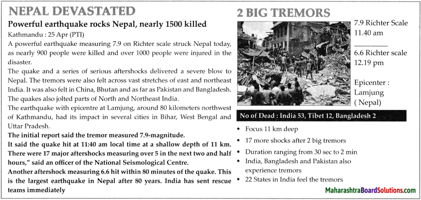
Read the following news. Observe the photograph and answer the questions.
Maharashtra Board Class 9 Geography Solutions Chapter 2 Endogenetic Movements 3

Question 1.
What caused large-scale casualties?
Answer:
Calamity of earthquake led to large scale casualties.

Maharashtra Board Class 9 Geography Solutions Chapter 2 Endogenetic Movements

Question 2.
What was the magnitude of the earthquake?
Answer:
The magnitude of the earthquake was 7.9 Richter scale.

Question 3.
Which country was the most affected because of this earthquake?
Answer:
Nepal was most affected because of this earthquake.

Question 4.
Where was the epicentre of the earthquake?
Answer:
Lamjung in Nepal was the epicentre of the earthquake.

Question 5.
Which are the other affected areas?
Answer:
Bihar, West Bengal and Uttar Pradesh in India as well as China, Bhutan, Pakistan and Bangladesh were affected by earthquake.

Question 6.
At what depth was the focus located?
Answer:
The focus of the earthquake was located at the depth of 11 km.

Question 7.
What kind of damage is seen because of the earthquake?
Answer:
Nearly 1500 people were killed and over 1000 people were injured in the disaster.

Question 8.
According to you, what could be the reason behind the earthquake?
Answer:
The sudden release of energy from the interior of the earth leads to earthquakes.

Question 9.
Have you ever experienced a similar earthquake? Discuss.
Answer:
Answers may vary.

Class 9 Geography Chapter 2 Endogenetic Movements Additional Important Questions and Answers

Complete the statements choosing the correct option from the bracket:

Question 1.
Richter scale is a unit of measuring the magnitude of a/an
(a) volcano
(b) creation of plate
(c) earthquake
(d) earth movement
Answer:
(c) earthquake

Maharashtra Board Class 9 Geography Solutions Chapter 2 Endogenetic Movements

Question 2.
There are in all major plates on the Earth.
(a) five
(b) seven
(c) nine
(d) four
Answer:
(b) seven

Question 3.
Large scale and sudden release of energy in the interior of the Earth gives rise to Earth movements.
(a) slow
(b) sudden
(c) internal
(d) external
Answer:
(b) sudden

Question 4.
Earthquakes occur due to the movement of
(a) plates
(b) earth
(c) oceans
(d) land
Answer:
(a) plates

Question 5.
Earthquake is measured with the help of an instrument called a
(a) seismogram
(b) thermometer
(c) barometer
(d) hygrometer
Answer:
(a) seismogram

Question 6.
If lava is released through a vent, it is called a vent volcano.
(a) fissure
(b) central
(c) upper
(d) below
Answer:
(b) central

Question 7.
Kilimanjaro is a volcano.
(a) central type
(b) fissure type
(c) extinct type
(d) dormant type
Answer:
(a) central type

Maharashtra Board Class 9 Geography Solutions Chapter 2 Endogenetic Movements

Question 8.
A tremendous amount of energy is given out by the radioactive elements in the
(a) crust
(b) core
(c) mantle
(d) sial
Answer:
(c) mantle

Question 9.
The movements that give rise to mountains are called movements.
(a) epiorogenic
(b) orogenic
(c) slow
(d) sudden
Answer:
(b) orogenic

Question 10.
When a portion of the crust between two parallel faults2 is raised up, it is called a mountain.
(a) block
(b) fold
(c) residual
(d) ancient
Answer:
(a) block

Question 11.
The area between two adjoining faults subsides, such area of subsidence is called
(a) rift valley
(b) block mountain
(c) fold mountain
(d) faulting
Answer:
(a) rift valley

Question 12.
Black Forest Mountain in Europe is a mountain.
(a) fold
(b) residual
(c) block
(d) ancient
Answer:
(c) block

Question 13.
The movements that give rise to continents are
(a) orogenic
(c) fold
(b) epeirogenic
(d) fault
Answer:
(b) epeirogenic

Maharashtra Board Class 9 Geography Solutions Chapter 2 Endogenetic Movements

(Endogenetic Movements Class 9 Geography Chapter 2 )Tick in front of the correct option.

Question 1.
Which of these is a block mountain?
(a) Black forest mountain
(b) Alps
(c) Andes
Answer:
(a) Black forest mountain

Question 2.
Which type of volcano has eruptions regularly even during present times?
(a) Dormant
(b) Extinct
(c) Active
Answer:
(c) Active

Give one word for each of the following:

Question 1.
A volcano, where lava reaches the surface through a vent or a pipe.
Answer:
Central Vent Volcano

Question 2.
An instrument, which is used for recording earthquakes.
Answer:
Seismogram

Question 3.
The surface position immediately above the origin of an earthquake.
Answer:
Epicenter

Question 4.
An example of a volcanic plateau.
Answer:
Deccan Plateau.

Question 5.
An example of Conical volcanic mountains.
Answer:
Mt. Kilimanjaro

Maharashtra Board Class 9 Geography Solutions Chapter 2 Endogenetic Movements

(Class 9 Geography Chapter 2 Endogenetic Movements Questions And Answers ) Answer in one sentence each.

Question 1.
What are Endogenetic processes?
Answer:
Endogenetic processes are processes that originate internally in the Earth’s surface. E.g. earthquakes, volcanoes, continent building, mountain building etc.

Question 2.
What is a Richter scale?
Answer:
It is a scale for expressing the magnitude of an earthquake.

Question 3.
What is a Focus or Hypocentre?
Answer:
The point below the Earth’s surface where energy is released during an earthquake is called the focus of the earthquake.

Question 4.
What are Primary Waves?
Answer:
The earthquake waves that reach the surface of the Earth first, immediately after the energy is released in the interior of the Earth, are called Primary waves.

Question 5.
What are Secondary Waves?
Answer:
The earthquake waves reporting at the surface after the primary waves are called the secondary waves.

Question 6.
What are Surface Waves?
Answer:
Primary and secondary waves affect the surface on reaching it. As a result a new set of waves gets generated at the surface. These waves are called surface waves.

Question 7.
What are Plates?
Answer:
The parts of varying sizes of the Earth’s crust floating on the upper portion of the mantle are called plates.

Question 8.
What do you mean by an Epicentre?
Answer:
The point located on the surface of the Earth nearest to the focus is called the epicenter of the earthquake.

Question 9.
Explain Orogenic Movements
Answer:
The slow movements in the interior of the Earth that give rise to mountains are called orogenic movements (mountain building movements).

Maharashtra Board Class 9 Geography Solutions Chapter 2 Endogenetic Movements

Question 10.
What is Folding1?
Answer:
As energy moves through the interior of the Earth, soft rocks are subjected to pressure leading to creation of folds called folding.

Question 11.
Define Fault.
Answer:
The fracture line created in a rock due to the energy waves moving away from each other is called a fault.

Question 12.
What is a Block Mountain?
Answer:
A raised portion of the crust between two parallel faults is called a block mountain.

Question 13.
What is a Rift valley?
Answer:
The area of subsidence between two adjoining faults is called a rift valley.

Question 14.
Explain Epeirogenic Movements.
Answer:
The Earth’s slow movements that give rise to continents and extensive plateaus are called epeirogenic movements.

Question 15.
Explain the process of Volcanic Eruption.
Answer:
A process in which hot solid, liquid and gaseous materials are thrown out from the mantle of the earth onto the surface of the earth, is called volcanic eruption.

Identify and name the internal movements.

Question 1.
Dust, smoke and mud with some lava coming out of Barren Island.
Answer:
Sudden Movement

Maharashtra Board Class 9 Geography Solutions Chapter 2 Endogenetic Movements

Distinguish between:

Question 1.
Seismic Focus and Epicentre
Answer:

Seismic FocusEpicenter
(i) The point below the surface where energy is released during an earthquake is called the seismic focus of the earthquake.(i) The place on the surface which is directly above the focus and closest to it is called the epicenter.
(ii) From the seismic focus, an energy wave radiates in all directions.(ii) Seismic waves reach the epicenter first and foremost and so its intensity is the maximum at this point.

Question 2.
Central Type Volcano and Fissure Type Volcano
Answer:

Central Type VolcanoFissure Type Volcano
(i)Lava is released through a pipe-like vent, hence it is called central type volcano.(i)Lava is released through a number of fissures or cracks, hence it is called fissure type volcano.
(ii)The ejected material gets settled near the mouth of the central vent, giving rise to conical hills.(ii)The ejected material spreads on either side of the fissures and forms volcanic plateaus.
(iii)e.g. Mt. Fujiyama of Japan, Mt. Kilimanjaro in Tanzania.(iii)e.g. the Deccan plateau of India

Question 3.
Orogenic Movements and Epeirogenic Movements
Answer:

Orogenic MovementsEpeirogemic Movements
(i) The movements that give rise to mountains are called Orogenic Movements.(i) The movements that give rise to continents are called Epeirogenic Movements.
(ii) They lead to the formation of Fold mountains, Block mountains and Rift valleys.(ii) They lead to the formation of continents and extensive plateaus.

Question 4.
Slow Internal Movements and Sudden Internal Movements
Answer:

Slow Internal MovementsSudden Internal Movements
(i) The movements in the interior of the earth that are caused by continuous and slow release of energy are called slow internal movements(i) The movements in the interior of the earth that are caused by the sudden release of energy on a large scale are called sudden internal movements.
(ii) Slow internal movements give rise to mountains and continents.(ii) Sudden internal movements lead to earthquakes and volcanic eruptions.

Make friends with Maps!
Maharashtra Board Class 9 Geography Solutions Chapter 2 Endogenetic Movements 4
Answer the following questions:

Question 1.
Examine the plate boundaries in the given map and write the names of the plates.
Answer:
North American Plate, South American Plate, Indo-Australian Plate, African Plate, Eurasian Plate, Pacific Plate, Antarctic Plate, Arabian Plate, Nazca Plate, Cocos Plate, Caribbean Plate, Scotia Plate, Arabian Plate and Somali Plate.

Maharashtra Board Class 9 Geography Solutions Chapter 2 Endogenetic Movements

Question 2.
On which side of the continents of North and South America are the earthquake-prone zones located? Which mountains are located there?
Answer:
The earthquake-prone zone is located on the western side of North and South America. Rockies and Andes mountain ranges are located there.

Question 3.
In which mountainous zone in Asia does the earthquake-prone zone lie?
Answer:
The Himalayan mountainous zone of Asia is an earthquake-prone zone.

Question 4.
In which region are the volcanoes concentrated in Africa? What could be the reason?
Answer:
Volcanoes are concentrated in the eastern part of Africa along the Rift Valley region as this region is located on plate boundaries.

Question 5.
Correlate earthquake regions, distribution of volcanoes and plate boundaries.
Answer:
Plate boundaries are directly related to areas of earthquakes and volcanoes. Most of the volcanoes are located on the plate boundaries. Similarly, the earthquake zones are also seen in the border areas.

Give geographical reasons:

Question 1.
The secondary earthquake waves are very destructive.
Answer:

  • Due to secondary earthquake waves, the grains in the rocks move up and down, that is, perpendicular to the direction of the movement of the waves.
  • Therefore, secondary waves are very destructive.

Answer in brief:

Question 1.
Explain the types of volcanoes on the basis of their type of eruption, with examples.
Answer:
On the basis of the type of eruption, volcanoes can be divided into two types.
(i) Central-type or conical volcano:

  • During eruption, the molten magma comes out through a pipe-like vent from inside the Earth’s surface. The lava spreads around the mouth of this vent, when it comes out.
  •  Asa result, cone-shaped mountains start forming and conical volcanic mountains are formed.
  • Mt. Fujiyama in Japan and Mt. Kilimanjaro in Tanzania are examples of central-type volcanoes and conical mountains.

Maharashtra Board Class 9 Geography Solutions Chapter 2 Endogenetic Movements

(ii) Fissure-type volcano:

  • During eruption, when the magma comes out not from a single vent, but from many cracks (fissures), it is called fissure-type volcanic eruption.
  • The molten material coming out with the eruption spreads on both the sides of the fissure. ;
  • As a result, volcanic plateaus are formed.
  • The Deccan Plateau of India has also been formed due to such a type of volcanic eruption.

Question 2.
Describe the changes that take place on the surface of the Earth, due to the movements taking place in the interior of the Earth.
Answer:
The changes taking place on the surface of the Earth, due to the internal movements of the Earth are as follows:

  1. The soft rocks are subjected to pressure due to the energy released in the interior of the Earth. This leads to the development of folds.
  2. If the pressure is very high, large scale folds are formed, and their complexity increases. As a result, the surface of the Earth gets uplifted and fold mountains are formed.
  3. When the energy waves move away from each other, tension in the rock is developed. In hard rocks, the tension leads to faulting, when a portion between two parallel faults is raised up, block mountains are created.
  4. Sometimes, when the portion between two parallel faults subsides, a rift valley is created.
  5. Sometimes, an extensive portion is raised to form a continent or an extensive plateau.

Question 3.
How are continents and extensive plateaus formed?
Answer:

  • The epeirogenic movements are responsible for the formation of continents.
  • Slow movements occur towards the centre or from the Earth’s centre towards the Earth’s crust.
  • Because of these movements, a vast part of the Earth’s crust is uplifted or gets subsided.
  • When the part of the Earth’s crust is uplifted above the sea mean level, continents are formed.
  • Therefore, these movements are called continent-building movements.
  • Extensive plateaus can also be formed because of such movements.

Question 4.
What are the effects of volcanoes?
Answer:
The following are the effects of volcanoes:

  • Loss of life and property.
  • Sometimes tsunamis get generated due to volcanic eruptions occurring below ocean floors.
  • Dust, smoke, ash, gases, water vapour, etc. remain in the atmosphere for a long time.
  • This may create an imbalance in the environment.
  • Land may become fertile due to volcanic ash.
  • Many minerals are found near the earth’s surface because of lava.
  • New land is formed due to volcanic eruption or at times, an island may even disappear.
  • Lakes are formed at the mouth of the craters of dead volcanoes when rainwater accumulates in them.

Maharashtra Board Class 9 Geography Solutions Chapter 2 Endogenetic Movements

Question 5.
Explain the process of the formation of Block mountains.
Answer:

  • Because of internal movements, horizontal waves moving away from each other are formed.
  • This causes tension on the layers of rocks leading to the formation of fractures in the rocks called as faults.
  • Similarly, waves coming towards each other in hard rocks also form faults due to compression.
  • When a part of the earth’s crust in between two parallel faults is lifted, it looks like a block. Such a landform is called as a Block mountain.
    Maharashtra Board Class 9 Geography Solutions Chapter 2 Endogenetic Movements 5

Question 6.
Explain the process of formation of Rift valley.
Answer:

  • When horizontal movements on the earth’s surface act in opposite direction, it causes tension on the rocks in the earth’s crust.
  • When tension increases, fractures develop in the rocks leading to the formation of faults.
  • Consequently, rocks on both the ends slide and the continuity in the layers of rocks is not found.
  • Sometimes, two fractures develop side-by-side in the earth’s crust and land in between the two fractures subsides. This subsided deep part is called the rift valley.
    Maharashtra Board Class 9 Geography Solutions Chapter 2 Endogenetic Movements 6

Maharashtra Board Class 9 Geography Solutions Chapter 2 Endogenetic Movements

Maharashtra Board Class 10 Marathi Kumarbharati Solutions उपयोजित लेखन

Balbharti Maharashtra State Board Class 10 Marathi Solutions Kumarbharati उपयोजित लेखन Notes, Textbook Exercise Important Questions, and Answers.

Maharashtra State Board Class 10 Marathi Kumarbharati उपयोजित लेखन

Maharashtra Board Class 10 Marathi Kumarbharati Solutions उपयोजित लेखन

पत्रलेखनासंबंधी थोडी माहिती:
पत्रलेखनाचे प्रकार पत्रलेखनाचे स्थूलमानाने दोन प्रकार:
(१) अनौपचारिक पत्रे
(२) औपचारिक पत्रे.
(१) अनौपचारिक पत्रे:

आई, वडील, भाऊ, बहीण वा इतर कोणी आप्त आणि मित्र यांना उद्देशून लिहिलेली पत्रे, ही अनौपचारिक पत्रे होत. हल्ली संदेशवहनातील प्रचंड क्रांतीमुळे अनौपचारिक पत्रे लिहिण्याची गरज जवळजवळ संपुष्टात आली आहे. त्यामुळे वैयक्तिक स्तरावरील पत्रव्यवहार हल्ली फारच कमी प्रमाणात होतो.

इंटरनेट, संगणक, मोबाइल फोन यांमुळे वैयक्तिक स्तरावरील पत्रव्यवहार मंदावला आहे, हे खरे असले, तरी त्यांच्यामुळे पत्रव्यवहार चालूसुद्धा राहिला आहे. काही वेळा माणसे कामात असतात. संपर्क होऊ शकत नाही. अशा वेळी ई-मेलद्वारे पत्रे पाठवली जातात. किंबहुना आता तंत्रज्ञानाचा प्रभाव व सुलभता यांमुळे ई-मेलचा प्रसार खूपच वाढला आहे. ई-मेलवरील पत्रलेखनाची एक विशिष्ट पद्धत आहे. पारंपरिक पत्रलेखनाहून थोडी वेगळी आहे. ई-मेलवरील पत्रलेखनाचे संकेतही थोडे वेगळे आहेत. यापुढे तंत्रज्ञानाच्या आधारेच पत्रव्यवहार प्राधान्याने होणार असल्याने त्या पद्धतीचा परिचय होणे आवश्यक आहे, म्हणून पत्राचे प्रारूप ई-मेल पद्धतीनुसार स्वीकारले आहे.

या वर्षापासून दहावीच्या अभ्यासक्रमात कौटुंबिक स्वरूपाच्या पत्रांचा समावेश केलेला आहे.

अनौपचारिक पत्र लिहिताना बाळगायची दक्षता :
(१) अनौपचारिक पत्रात एखाद्या व्यक्तीला लिहिलेल्या पत्राचा नमुना तयार करायचा आहे. उदा., अभिनंदनपर पत्र,
(२) पत्राच्या वरच्या बाजूस डाव्या कोपऱ्यात तारीख लिहावी.
(३) पत्राचा विषय लिहिण्याची आवश्यकता नाही.
(४) पत्र कोणत्या व्यक्तीला लिहीत आहोत, हे लक्षात घेऊन मायना लिहावा.

Maharashtra Board Class 10 Marathi Kumarbharati Solutions उपयोजित लेखन

(५) पत्रातील मजकूर लिहिताना योग्य तेथे परिच्छेद पाडावेत.
(६) पत्राचा समारोप योग्य प्रकारे करावा. आईवडिलांना “शिरसाष्टांग नमस्कार’ किंवा ‘शि. सा. नमस्कार’ आणि कुटुंबातील इतरांना सा. न./साष्टांग नमस्कार/नमस्कार/आशीर्वाद यांपैकी योग्य ते शब्द लिहावेत.
(७) समारोपाचा मायना योग्य असावा.
(८) पत्राची भाषा सहज बोलल्यासारखी व घरगुती असावी.

(२) औपचारिक पत्रे :
दैनंदिन जीवनात आपल्या काही अडचणी सोडवण्यासाठी किंवा काही सुविधा मिळवण्यासाठी आपल्याला शासकीय कार्यालयांत किंवा खाजगी कंपन्यांच्या कार्यालयांत जावे लागते. आपली कामे व्हावीत म्हणून या कार्यालयांत आपल्याला पत्रे सादर करावी लागतात. या पत्रांना ‘औपचारिक पत्रे’ म्हणतात.

कधी कधी आपल्याला त्रयस्थ व्यक्तींनाही काही कामानिमित्त पत्र लिहावे लागते. हेही ‘औपचारिक पत्र ‘च होय, आपली कामे कोणालाही त्रास न होता, बिनचूक व त्वरेने होण्यासाठी अशी पत्रे विशिष्ट पद्धतीने लिहिली जातात. त्यांची एक ठरलेली रूपरेषा असते. त्यात शिष्टाचार व उपचार पाळावे लागतात. या पत्रांत पाल्हाळ, फापटपसारा नसतो. कामाचे स्वरुप थोडक्यात व अत्यंत नेमकेपणाने स्पष्ट केलेले असते. मित्रांना किंवा नातेवाईकांना लिहिलेल्या पत्रात जशी सलगी व्यक्त होते, तशी सलगी औपचारिक पत्रात नसते. ही औपचारिक पत्राची वैशिष्ट्ये आहेत.

औपचारिक पत्रांचे स्थूलमानाने पुढीलप्रमाणे काही उपप्रकार मानले जातात:
(१) निमंत्रणपत्र
(२) आभारपत्र
(३) अभिनंदनपत्र किंवा गौरवपत्र
(४) चौकशीपत्र
(५) क्षमापत्र
(६) मागणीपत्र
(७) विनंतिपत्र
(८) तक्रारपत्र

Maharashtra Board Class 10 Marathi Kumarbharati Solutions उपयोजित लेखन

औपचारिक पत्र लिहिताना बाळगायची दक्षता :
(१) पत्राची सुरुवात करताना वरच्या डाव्या कोपऱ्यात दिनांक लिहावा.
(२) प्रेषक व प्रति यांचे पत्ते कृतिपत्रिकेत दिलेले असतील; तर तेच लिहावेत; पत्ते दिलेले नसतील, तर ते काल्पनिक लिहावेत.
(३) प्रेषक व प्रति यांची नावे दिलेली असल्यास तीच लिहावीत.

अन्यथा अ.ब.क, किंवा तत्सम अक्षरे लिहावीत. सही करू नये.

(४) औपचारिक पत्रात ‘मायना’ लिहिल्यावर त्यानंतरच्या
ओळीत ‘विषय’ लिहावा. ‘संदर्भ’ दयायचा असेल, तर तो ‘विषया नंतरच्या ओळीत लिहावा.
(५) त्यानंतरच्या ओळीत आवश्यकतेप्रमाणे ‘महोदय’/’महोदया’ हे संबोधन लिहावे आणि स्वल्पविराम दयावा. (‘मा. महोदय/महोदया’ किंवा ‘माननीय महोदय/महोदया’ असे लिहू नये. फक्त ‘महोदय’/’महोदया’ एवढेच लिहावे.)
(६) त्यानंतरच्या ओळीत मजकुराला सुरुवात करावी.
(७) ‘आपला विश्वासू’, ‘आपला कृपाभिलाषी’ या शब्दांनी शेवट करून त्याखाली आवश्यकतेप्रमाणे अ.ब.क किंवा नाव आणि पत्ता लिहावा. अभ्यासक्रमातील पत्रांचे स्वरूप :

१. कौटुंबिक पत्रे :
आई, वडील, भाऊ, बहीण, अन्य आप्त, मित्रमंडळी वगैरेंना विविध कारणांनी लिहिली जाणारी पत्रे ही कौटुंबिक पत्रे होत. या माणसांशी असलेले नाते आपुलकीचे, जिव्हाळ्याचे असते. प्रत्येक व्यक्तीशी आपला जसा संबंध असतो, तसे पत्र लिहिले जाते. म्हणून ही पत्रे चाकोरीबद्घ नसतात. ती मोकळीढाकळी असतात. तरीही या प्रकारच्या पत्रलेखनाचे काही संकेत निर्माण झाले आहेत. साधारणपणे खुशाली, अभिनंदन, परीक्षा वगैरेंमधील यश, जन्म-मृत्यू यासंबंधीची माहिती अशा अनेक बाबी (ज्याच्या संबंधात संबंधित व्यक्तींना

Maharashtra Board Class 10 Marathi Kumarbharati Solutions उपयोजित लेखन

जिव्हाळा वाटत असतो त्या बाबी) एकमेकांना कळवण्यासाठी, भावनाविचारांची देवाणघेवाण करण्यासाठी पत्रे लिहिली जातात. व्यक्तिगत जीवनातील सर्व बाबी कौटुंबिक पत्रात येऊ शकतात.

२. मागणीपत्र :

एखादया वस्तूची किंवा सेवेची मागणी करण्यासाठी लिहिलेले पत्र म्हणजे ‘मागणीपत्र’ होय, सार्वजनिक जीवनात सौजन्याने वागण्याचे संकेत असतात, म्हणून पत्रात विनंतीची भाषा वापरली जाते. मात्र, पत्राच्या केंद्रस्थानी मागणीच असते. मागणीपत्राची काही वैशिष्ट्ये :
(१) मागणी पुरवणाऱ्याला योग्य तो मोबदला देण्याची आपली तयारी असते.
(२) पैशाच्या बदल्यात वस्तू-सेवा देण्याघेण्याचा रोकडा व्यवहार. त्यात भावनेचा अंश कमी असतो.
(३) वस्तूचा दर्जा चांगला असावा, विक्रीनंतरची सेवा उपलब्ध असावी इत्यादी अपेक्षा असतात.
(४) किंमत वाजवी असावी, अशीही अपेक्षा असतेच.

३. विनंतिपत्र :
(१) एखादया व्यक्तीला किंवा संस्थेला लिहिलेले कोणत्याही स्वरूपातील मदत करण्याची विनंती करणारे पत्र म्हणजे ‘विनंतिपत्र’ होय. मदत करणे हे त्या संबंधित व्यक्तीच्या पूर्णपणे इच्छेवर अवलंबून असते. म्हणून संबंधित व्यक्तीला विनंतीच करावी लागते. मुख्य विषयाबरोबर विनंतीची भावनाही केंद्रस्थानी आहे. म्हणून हे विनंतिपत्र होय.

Maharashtra Board Class 10 Marathi Kumarbharati Solutions उपयोजित लेखन

(२) निमंत्रणे देणे, देणगी मागणे, स्थळभेटीसाठी परवानगी घेणे, एखादया तज्ज्ञ व्यक्तीच्या ज्ञानाचा, व्यासंगाचा, अनुभवाचा लाभ व्हावा म्हणून त्या व्यक्तीला निमंत्रण देणे. अग्निशमनदलासारख्या संस्थांना मार्गदर्शनासाठी बोलावणे, ‘शालेय समिती’मध्ये सहभागी होण्यासाठी नगरसेवक किंवा सरपंच यांना आमंत्रित करणे, विदयाथ्यांच्या समस्या सोडवण्यासाठी पालकांना आवाहन करणे यांसारख्या प्रसंगांत विनंतिपत्रे लिहिली जातात.

औपचारिक ई-पत्राचा आराखडा
Maharashtra Board Class 10 Marathi Solutions उपयोजित लेखन 1

अनौपचारिक ई-पत्राचा आराखडा
Maharashtra Board Class 10 Marathi Solutions उपयोजित लेखन

Maharashtra Board Class 10 Marathi Kumarbharati Solutions उपयोजित लेखन

पत्रलेखन नमुना कृती:
पुढील निवेदन वाचा व त्याखालील कृती सोडवा:
Maharashtra Board Class 10 Marathi Solutions उपयोजित लेखन 2

१. मागणी पत्र
उत्तर:
दिनांक : ३.११.२०१९
प्रति,
मा. व्यवस्थापक,
आनंद पुस्तकालय,
१०२, विकास नगर, गाळा क्र. २,
जालना.
विषय : पुस्तकांची मागणी करण्याबाबत.
महोदय,
आजच्या वर्तमानपत्रातून आलेले आपल्या पुस्तकालयाचे हॅन्डबिल मी नुकतेच वाचले. आपण या पंधरवड्यासाठी सर्व पुस्तकांवर २०% सवलत देऊ केलेली आहे. मला हव्या असलेल्या पुस्तकांची यादी पुढे देत आहे. कृपया मला २०% सवलत दयावी आणि पुस्तके घरपोच देण्याची व्यवस्था करावी. टपालखर्च मी देईन. मी सदर पुस्तकांची नावे माझ्या मराठीच्या पाठ्यपुस्तकातून घेतली आहेत. त्यामुळे त्यांच्या किमती मला ठाऊक नाहीत. तरी सवलत वजा करून येणारी देय रक्कम आणि टपालखर्च ही एकूण रक्कम किती येते, ते कृपया माझ्या या ई-मेलला उत्तर देऊन कळवावे. त्या उत्तरातच आपण आपल्या बँक खात्याचा तपशील कळवला, तर मी ती रक्कम आपल्या खात्यात त्वरित ऑनलाइन भरीन. माझ्या पुस्तकांची यादी :

१. गुजगोष्टी – ना. सी. फडके (व्हीनस प्रकाशन)
२. शब्दांची पहाट – नीलिमा गुंडी (ग्रंथाली प्रकाशन)
कळावे, Maharashtra Board Class 10 Marathi Kumarbharati Solutions उपयोजित लेखन
आपला नम्र,
अ. ब. क.
११, शुक्रतारा,
जवाहर नगर, जालना – ४३१ २०३.
[email protected]

२. विनंतिपत्र
उत्तर :
३ नोव्हेंबर २०१९.
प्रति,
मा, व्यवस्थापक,
आनंद पुस्तकालय,
१०२, विकास नगर, गाळा क्र. २,
जालना – ४३१ २०३
विषय : पुस्तकांवर अधिक सवलत देण्याबाबत.
महोदय,
मी, अ. ब. क, सरस्वती विद्या मंदिर या शाळेचा शालेय भांडार प्रमुख या नात्याने हे पत्र लिहित आहे.

आजच वर्तमानपत्रातून आलेले आपल्या पुस्तकालयाच्या वर्धापनदिनाबाबतचे पत्रक वाचले आणि आनंद झाला. वर्धापनदिनानिमित्त आपण पस्तक खरेदीवर २०% सवलत जाहीर केली आहे. आपले ‘आनंद पुस्तकालय’ आणि आमची शाळा यांचे गेल्या अनेक वर्षांचे ऋणानुबंध आहेत. गेली अनेक वर्षे आपण आमच्या शाळेला लागणारी सर्व प्रकारची पुस्तके पुरवीत आला आहात.

Maharashtra Board Class 10 Marathi Kumarbharati Solutions उपयोजित लेखन

सध्या पुस्तकांच्या किमती बऱ्याच वाढल्या आहेत. शाळेचे अनेक खर्च मोठ्या प्रमाणात वाढले आहेत. शासनाकडून मिळणारे अनुदान वाढत्या खर्चाला पुरे पडत नाही. अलीकडे देणग्या मिळवणेसुद्धा जिकिरीचे झाले आहे. म्हणून आपल्याला कळकळीची विनंती आहे की, आपण आपल्या वर्धापनदिनानिमित्ताने आमच्या शाळेला पुस्तक खरेदीवर २०% पेक्षा जास्त सवलत दयावी. आम्ही आमची पुस्तकांची यादी चार दिवसांपूर्वीच आपल्याकडे पाठवली आहे.

आपल्या अनुकूल प्रतिसादाची आम्ही वाट पाहत आहोत. सवलत वजा जाता येणारी देय रक्कम कृपया उलट मेलने कळवावी. म्हणजे ती देय रक्कम आम्ही आपल्या बँक खात्यात नेहमीप्रमाणे त्वरित भरू.

हे पत्र मी मा. मुख्याध्यापकांच्या अनुमतीने लिहित आहे. कळावे,
आपला नम्र,
अ. ब. क.
(शालेय मांडार प्रमुख)
सरस्वती विद्या मंदिर,
जवाहर नगर, जालना – ४३१. २०३.
[email protected]

Maharashtra Board Class 9 Geography Solutions Chapter 6 Properties of Sea Water

Balbharti Maharashtra State Board Class 9 Geography Solutions Chapter 6 Properties of Sea Water Notes, Textbook Exercise Important Questions and Answers.

Maharashtra State Board Class 9 Geography Solutions Chapter 6 Properties of Sea Water

Class 9 Geography Chapter 6 Properties of Sea Water Textbook Questions and Answers

1. Tick the correct box according to the salinity of the ocean water ✓

Maharashtra Board Class 9 Geography Solutions Chapter 6 Properties of Sea Water 1
Answer:
(a) Low
(b) Low
(c) High
(d) High
(e) Low
(f) High.

Maharashtra Board Class 9 Geography Solutions Chapter 6 Properties of Sea Water

2. Give reasons.

(a) Salinity is low in the land-locked Baltic Sea.
Answer:

  • The Baltic Sea lies in the temperate region.
  • In temperate regions, the sunrays are slanting and therefore, the temperatures are lower.
  • The supply of fresh water is also more, as numerous rivers empty their waters into the Baltic sea.
  • Therefore, in spite of being landlocked, due to low rate of evaporation and ample supply of fresh water, the salinity of the Baltic Sea is low.

(b) There is higher salinity in the northern Red Sea while lower in the southern.
Answer:

  • The Red Sea is one of the saltiest bodies of water in the world, owing to high evaporation.
  • The salinity is 36%o in the southern part because of the effect of the Gulf of Aden.
  • It reaches 41 %o in the northern part, owing mainly to the Gulf of Suez and the high evaporation as well as very little precipitation.
  • Hence, there is more salinity in the northern Red Sea while lesser in the south.

(c) Oceans located at the same latitude do not have same salinity.
Answer:

  • The salinity of the oceans depends on factors like rate of evaporation and supply of fresh water.
  • In Oceans where rate of evaporation is more than the supply of fresh water, the salinity is higher.
  • In Oceans where supply of freshwater exceeds the rate of evaporation, salinity is low.
  • Salinity is not affected much in areas where supply of freshwater and the evaporation of water is low.
  • Thus, oceans located on the same latitude do not have the same salinity.

(d) With increasing depth, the temperature of sea water decreases to a certain limit.
Answer:
With increasing depth, the temperature of sea water decreases to a certain limit because –

  • While most of the sunrays radiate back from the surface of the sea, some of them penetrate to certain depths in the water.
  • As a result, the intensity of sunrays decreases with the increasing depth.
  • The temperature decreases up to 2000m depth.
  • After 2000m, the temperature of the seawater is uniform everywhere.

Maharashtra Board Class 9 Geography Solutions Chapter 6 Properties of Sea Water

(e) There are more salt-pans on the Western coast of India than its eastern coast.
Answer:

  • The Arabian Sea lies lying to the west and Bay of Bengal lies to the east of India.
  • Many large peninsular rivers drain their waters in the Bay of Bengal and on the contrary, only small seasonal coastal rivers drain in the Arabian Sea.
  • Hence, the salinity of the eastern coast is 34%, while it is 35% in the Arabian Sea.
  • Thus, there are more salt-pans on the Western coast of India than its Eastern coast.

(f) Salinity increases in the mid-latitudinal zones.
Answer:

  • Mid-latitudinal zones lies between 25° to 35° north and south of the equator.
  • In this zone, the rainfall is less and the supply of fresh water from rivers is also low.
  • This region experiences high-temperature conditions which are marked by the presence of hot deserts of the world. These high-temperature conditions lead to a high rate of evaporation.
  • Thus, the salinity of the seas is found to be higher in mid-latitudinal zones.

3. Answer the following questions.

(a) What are the factors affecting the salinity of the sea water?
Answer:

  1. The uneven distribution of temperature on earth and uneven supply of freshwater affects the salinity of seawater.
  2. In the tropical zone, temperature is higher. Rate of evaporation is also higher and therefore, the salinity is higher.
  3. Around 5° N and S of the equator, in the equatorial calm belt, the sky is cloudy for a long period of time and convectional rainfall occurs every day.
  4. Large rivers like Congo and Amazon in the equatorial regions meet the sea. Therefore, supply of freshwater is abundant, too. But because of higher temperatures, rate of evaporation is more and therefore, the seas in these areas are more saline.
  5. In mid-latitudinal zones (25° to 35° N and S), rainfall is lesser and the supply of freshwater from rivers is also low. This zone has the hot deserts of the world. Thus, the salinity of the seas is found to be higher here.
  6. In temperate regions, the sunrays are slanting and therefore, the temperatures are lower. Because of the melting of the snow, the supply of water is also more, and therefore, in this zone, salinity decreases with increasing latitudes.
  7. In the polar areas, temperatures are very low. Evaporation is also very less in polar areas. So, salinity is low.
  8. Landlocked seas have higher salinity than open seas as the rate of evaporation is more. There is a lack of supply of fresh water from large rivers. Thus, there is a difference in the salinities of open and closed seas.

Maharashtra Board Class 9 Geography Solutions Chapter 6 Properties of Sea Water

(b) Explain the distribution of salinity around the Tropic of Cancer and tropic of Capricorn.
Answer:

  • The uneven distribution of temperature on earth, and uneven supply of freshwater affects the salinity of sea water.
  • Region, between the Tropic of Cancer and Tropic of Capricorn is called as the Tropical zone.
  • In the tropical zone, temperature is higher.
  • Hence, the rate of evaporation is also higher, and therefore, salinity is higher.

(c) What are the factors affecting the temperature of the sea water?
Answer:

  1. Temperature is a major property of the sea water.
  2. Sea water upto the depth of 500m is called as surface water. The surface temperature of the sea water is not uniform everywhere. This is dependent on different factors. .
  3. Latitudinally, the surface temperature of the seawater decreases from the equatorial areas towards the poles.
  4. The average temperature in equatorial areas is around 25° C, while it is about 2° C near the poles.
  5. Besides this, cyclones, rainfall, sea waves, ocean currents, salinity, pollution, convectional currents, and seasons also affect the surface temperature.
  6. Regions where cold ocean currents flow, the surface temperature of ocean water is less, while the regions where the warm currents move, the temperature increase.

(d) Explain the changes occurring in the temperature of sea water according to the depth.
Answer:

  • While most of the sunrays radiate back from the surface of the sea, some of them penetrate to certain depths in the water.
  • As a result, the intensity of sunrays decreases with the increasing depth.
  • The temperature decreases up to 2000m depth.
  • After 2000m, the temperature of the seawater is uniform everywhere.
  • It is around 4°C everywhere from the equatorial regions to the polar areas.
  • Temperature reduces only up to 4° C according to depth, and therefore, the water at greater depths does not freeze.
  • The temperature of the seawater changes rapidly with depth at the equatorial areas. The difference in temperature is lesser in polar areas.
  • There is also a difference in open seas and landlocked seas. In low latitudes, because the salinity of the landlocked seas is more, the temperature of the landlocked seas is higher than the open seas.

Maharashtra Board Class 9 Geography Solutions Chapter 6 Properties of Sea Water

(e) Name the factors affecting salinity.
Answer:
Due to the sun’s heat, evaporation happens at a faster rate. Evaporated water turns into water vapour and reduces in quantity. But amount of salt remains the same in the remaining water and therefore the salinity of water increases.

  • In seas where the rate of evaporation is high than the supply of fresh water, salinity is high.
  • In seas where the supply of freshwater exceeds the rate of evaporation, salinity is low.
  • Salinity is not affected much in seas where both the supply of freshwater and evaporation of water is low.

4. Explain how temperature affects the following.

(a) the density of sea water
Answer:

  • If temperature reduces, density of water increases.
  • Hence, cold water is denser than hot water.

(b) the salinity of sea water
Answer:

  • If the salinity of water is high, the density of water increases.

Activity:

Complete the table showing the salinity of open and land-locked seas.
Maharashtra Board Class 9 Geography Solutions Chapter 6 Properties of Sea Water 3
Answer:
Maharashtra Board Class 9 Geography Solutions Chapter 6 Properties of Sea Water 2

Class 9 Geography Chapter 6 Properties of Sea Water Intext Questions and Answers

Observe the following Map and answer the questions:
Maharashtra Board Class 9 Geography Solutions Chapter 6 Properties of Sea Water 4

Question 1.
What is the salinity around the tropics?
Answer:
The salinity around the tropics is 36%o.

Maharashtra Board Class 9 Geography Solutions Chapter 6 Properties of Sea Water

Question 2.
Which region has the least salinity?
Answer:
The Bay of Bengal has the least salinity of 32%o.

Question 3.
Which ocean has salinity more than 37%o?
Answer:
Atlantic ocean has salinity of more than 37%o.

Question 4.
What are the reasons of differences in salinity on a global level?
Answer:
The uneven distribution of temperature on earth, and uneven supply of freshwater, etc. are the reasons for differences in salinity on a global level.

Observe the Graph and answer the questions:
Maharashtra Board Class 9 Geography Solutions Chapter 6 Properties of Sea Water 5

Question 1.
What is the maximum temperature of seawater in equatorial areas? How much is this temperature at a depth of 500 m?
Answer:
The maximum temperature of sea water in equatorial areas is 18° C. The temperature at the depth of 500 m is 11° C.

Question 2.
What is the temperature of seawater at the sea level in the mid-latitudes?
Answer:
The temperature of seawater at the sea level in the mid-latitudes is 14° C approximately.

Question 3.
How much has this temperature changed at 1500 m depth?
Answer:
The temperature is about 5° C at the depth of 1500 m. Thus the temperature of sea water at mid-latitudes has changed from 14°C at the sea level to about 5°C at the depth of 1500 m i.e. temperature has changed (reduced) by 9°C.

Maharashtra Board Class 9 Geography Solutions Chapter 6 Properties of Sea Water

Question 4.
What does the thermal graph for the high latitude say? What is its temperature at 500, 1000 and 1500 m depths?
Answer:
In high latitudes the temperature of sea water at all depths remains constant at 4° C.

Question 5.
After what depth does the seawater temperature remain stable everywhere?
Answer:
After 2000 m, the temperature of the sea water is uniform everywhere.

Maharashtra Board Class 9 Geography Solutions Chapter 6 Properties of Sea Water 6

Question 6.
With increasing depth, what decreases: temperature, salinity or density?
Answer:
Temperature and salinity decreases with increasing depth.

Question 7.
After what depth does the change in these factor become almost zero?
Answer:
After the depth of 1000 m there is no change in all these factors.

Question 8.
Till what depth is the change in these factors higher?
Answer:
The higher change can be seen up to a depth of about 500m.

Question 9.
Explain the correlation between all the three factors.
Answer:
If the temperature is less, density is more. If the salinity is less, then density is also less. However temperature affects the density more as compared to the salinity. If the temperature is less, then the density is more despite less salinity.

Let’s Recall.

Question 1.
Which is the largest water storage of the world?
Answer:
Oceans are the largest water storage of the world.

Maharashtra Board Class 9 Geography Solutions Chapter 6 Properties of Sea Water

Question 2.
Why is the seawater salty?
Answer:

  • Salt in the ocean comes from rocks on land.
  • Rivers carry dissolved salts to the ocean.
  • Water evaporates from the oceans to fall again as rain and to feed the rivers, but the salts remain in the ocean.

Question 3.
What are the reasons for high salinity in the oceans?
Answer:
High rate of evaporation and low supply of fresh water leads to high salinity in the oceans:

Question 4.
How can we obtain the salts from the ocean water?
Answer:

  • Sea water contains a large amount of common salt and the salts of other metals dissolved in it.
  • Near the sea-shore, the sea water is collected in shallow pits (salt pans) and allowed to evaporate in the sunshine.
  • In a few days, the water evaporates, leaving behind salt.
  • The salt so obtained is collected and transported to factories, where it is purified and packed for consumption.

Question 5.
What is the use of the salts in the oceans to us?
Answer:

  • The salts is used in the food we eat.
  • It is used for making various chemicals and medicines.
  • Salt is also used to preserve things for longer periods. It is also used in ice factories.

Can You Tell?

Question 1.
What is the difference in the temperatures of the land and the sea?
Answer:
During the daytime land is hotter than the sea whereas, during the night time land is cooler than the sea.

Question 2.
What would be the difference in the temperature of the seawater from the equatorial region to the polar areas?
Answer:
Latitudinally, the surface temperature of the seawater decreases from the equatorial areas towards the poles. The average temperature in equatorial areas is around 25° C while it is about 2° C near the poles.

Think about it.

Question 1.
If you think about India there is the Arabian sea to the west and the Bay of Bengal to the east. The salinity of the eastern coast is 34%o while it is 35%o in the Arabian sea. What could be the reason of higher salinity in the western coastal region?
Answer:
Many large peninsular rivers drain their waters in the Bay of Bengal and on the contrary only small seasonal coastal rivers drain in the Arabian sea. Hence the salinity of Arabian sea is more than the Bay of Bengal.

Try this.

Question 1.
In which container has the water increased or decreased?
Answer:

  • The water has increased in the container which is in the classroom in which freshwater was added.
  • The water has decreased in the container which was kept in the sun outside.

Maharashtra Board Class 9 Geography Solutions Chapter 6 Properties of Sea Water

Question 2.
What could be the reasons behind the decrease or increase?
Answer:

  • Since freshwater was added to one of the containers in the classroom the water level increased.
  • The water has decreased in the container which was kept outside in the sun due to evaporation.

Question 3.
What could be the reason behind the low and high salinity of the water in the container?
Answer:

  • In the container which as kept outside in the sun, due to high rate of evaporation, the salinity is high.
  • As we kept on adding fresh water to the container kept in the classroom the salinity is low.

Class 9 Geography Chapter 6 Properties of Sea Water Additional Important Questions and Answers

Select the correct option:

Question 1.
The average temperature in equatorial areas is
(a) 25° C
(b) 35° C
(c) 15° C
(d) 5° C
Answer:
(a) 25°C

Question 2.
The average temperature in mid-latitudes is
(a) 25° C
(b) 10° C
(c) 16° C
(d) 5° C
Answer:
(c) 16°C

Question 3.
The average temperature near poles is about
(a) 10° C
(b) 20° C
(c) 15° C
(d) 2° C
Answer:
(d) 2°C

Maharashtra Board Class 9 Geography Solutions Chapter 6 Properties of Sea Water

Question 4.
With the increasing depth of sea, the intensity of sunrays
(a) increases
(b) decreases
(c) remains constant
(d) is uneven
Answer:
(b) decreases

Question 5.
Seawater upto the depth of 500m is called
(a) ground water
(b) surface water
(c) deep water
(d) saline water
Answer:
(b) surface water

Question 6.
ocean is the most saline ocean in the world.
(a) Pacific
(b) Arctic
(c) Indian
(d) Atlantic
Answer:
(d) Atlantic

Question 7.
The sea lying on the border of Israel and Jordan has a salinity of %o.
(a) 37
(b) 50
(c) 256
(d) 332
Answer:
(d) 332

Question 8.
The buoyancy of the sea water increases because of its
(a) evaporation
(b) salinity
(c) density
(d) high temperature
Answer:
(b) salinity

Maharashtra Board Class 9 Geography Solutions Chapter 6 Properties of Sea Water

Question 9.
has an altitude of – 400m.
(a) Baltic Sea
(b) Arabian Sea
(c) Dead Sea
(d) the Mediterranean Sea
Answer:
(c) Dead sea

Question 10.
act as temperature controllers at a global level.
(a) Ocean currents
(b) Sea breeze
(c) Land breeze
(d) Trade winds
Answer:
(a) Ocean currents

Question 11.
is a major porperty of the sea water.
(a) Temperature
(b) Uniform salinity
(c) Buoyancy
(d) Equal Density
Answer:
(a) Temperature

Question 12.
have higher salinity than open seas.
(a) Equatorial seas
(b) Landlocked seas
(c) Freshwater lakes
(d) Seas in polar regions
Answer:
(b) landlocked seas

Question 13.
Temperature decreases upto depth.
(a) 500 m
(b) 1000 m
(c) 1500 m
(d) 2000 m
Answer:
(d) 2000m

Maharashtra Board Class 9 Geography Solutions Chapter 6 Properties of Sea Water

Question 14.
In regions where cold currents flow, the surface temperature of ocean water is
(a) high
(b) less
(c) uniform
(d) uneven
Answer:
(b) less

Question 15.
Temperature of seawater changes rapidly with depth in areas.
(a) equatorial
(b) mid latitudinal
(c) temperate
(d) polar
Answer:
(a) equatorial

Question 16.
In seas where the rate of evaporation is than the supply of fresh water, salinity is high.
(a) less
(b) high
(c) same
(d) low
Answer:
(b) high

Question 17.
The salinity of Bay of Bengal is than that of Arabian sea.
(a) less
(b) more
(c) same
(d) equal
Answer:
(a) less

Question 18.
In areas the salinity of sea water is low.
(a) equatorial
(b) mid-latitudinal
(c) temperate
(d) polar
Answer:
(d) polar

Maharashtra Board Class 9 Geography Solutions Chapter 6 Properties of Sea Water

Question 19.
The salinity of Battic sea is %.
(a) 332
(b) 32
(c) 37
(d) 7
Answer:
(d) 7

Match the Column:

Column AColumn B
(1) Equatorial areas
(2) Mid-latitudinal areas
(3) Temperate regions
(a) Salinity of 332%o
(b) Slanting sunrays, melting of snow
(c) Cloudy sky and convectional rainfall
(d) Hot deserts

Answer:
(1-c),
(2- d),
(3 – b)

Answer in one sentence:

Question 1.
What is the major property of seawater?
Answer:
Temperature is a major property of seawater.

Question 2.
What is the average surface temperature of seawater in equatorial areas, mid-latitudes & poles?
Answer:
The average surface temperature of seawater is equatorial areas is around 25°C in mid-latitude it is around 16°C & 2°C near the poles.

Question 3.
After what depth is the seawater temperature uniform everywhere?
Answer:
After 2000m, the temperature of seawater is uniform everywhere

Maharashtra Board Class 9 Geography Solutions Chapter 6 Properties of Sea Water

Question 4.
Name the instruments used to measure salinity?
Answer:
Hydrometer, Refractometer and salinometer are used to measure salinity.

Question 5.
Which is the most saline ocean?
Answer:
The Atlantic ocean is the most saline ocean.

Give geographical reasons:

Question 1.
The climate of the earth gets affected by ocean currents.
Answer:

  • The ocean currents are generated because of the difference in the properties of seawater.
  • They act as temperature controllers at the global level.
  • The distribution of temperature gets controlled due to the ocean currents.
  • Thus, the climate of the earth gets affected by ocean currents.

Question 2.
Dead Sea has a salinity of 332%0.
Answer:

  • The sea lying on the border of Israel and Jordan has a salinity of 332%0.
  • The average salinity of ocean is 35%o.
  • Jordan is the only large river meeting this sea.
  • Low rainfall, low supply of freshwater and high evaporation is the reason of high salinity.

Question 3.
The surface temperature of the sea is not uniform everywhere.
Answer:

  • The surface temperature of sea water is not uniform everywhere and it changes with latitudes.
  • The surface temperature of the seawater decreases from the equatorial areas towards the poles.
  • The average temperature in equatorial areas is around 25° C, it is 16° C in mid-latitudes while it is about 2° C near the poles.
  • Besides this, cyclones, rainfall, sea waves, ocean currents, salinity, pollution, convergence flow, seasons, etc. also affect the surface temperature.
  • Thus the surface temperature of the sea is not uniform everywhere.

Maharashtra Board Class 9 Geography Solutions Chapter 6 Properties of Sea Water

Question 4.
The seas in equatorial calm belt are more saline.
Answer:

  • Around 5° N and S of the equator, in the equatorial calm belt, the sky is cloudy for a long period of time and convectional rainfall occurs every day.
  • Large rivers like Congo and Amazon in the equatorial regions meet the sea.
  • Therefore, supply of freshwater abundant too.
  • But because of higher temperatures, rate of evaporation is more and therefore, the seas in these areas are more saline.

Explain

Question 1.
Factors affecting surface water temperature
Answer:

  • Temperature is a major property of the seawater. The surface temperature of the seawater is not uniform everywhere. This is dependent on different factors.
  • Latitudinally, the surface temperature of the seawater decreases from the equatorial areas towards the poles.
  • Besides this, cyclones, rainfall, sea waves, ocean currents, salinity, pollution, convergence flow and seasons also affect the surface temperature.
  • Regions where cold ocean currents flow, the surface temperature of ocean water is less. The regions where the warm currents move, the temperature increase.

Question 2.
Density of sea water
Answer:

  • Temperature and salinity are the two properties of sea water that control the density of the sea water.
  • If temperature reduces, density of water increases.
  • Cold water is denser, and so is saline water.
  • As compared to salinity, temperature affects the density more. Hence, sometimes, more saline water has lower temperature at the surface.
  • Sea water having higher temperature and low salinity, can have lower density.

Question 3.
Measurement of salinity of sea water.
Answer:

  • The weight of all dissolved salts in water in ratio of parts per thousand of water is called the salinity of seawater.
  • For example, if the weight of dissolved salts in 1000g (1 kg) of seawater is 40g, then the salinity is 40%o i.e. 40 per thousand parts.
  • Hydrometer, refractometer and salinometer are also used to measure salinity.

Maharashtra Board Class 9 Geography Solutions Chapter 6 Properties of Sea Water

Question 4.
Factors affecting salinity of sea water.
Answer:

LatitudesTemperature / Rate of evaporationSupply of fresh waterSalinity
Tropical Zone 5°N – 5°Sof equatorHighAbundant from (River Congo / Amazon)High
Mid­latitudes (25° – 35° N and S)High (hot desert are found here)lowHigh
Temperate regionsTemperature is lower due to slanting sunraysThe supply of water is more due to melting snowlow
Polar regionsVery lowlowlow