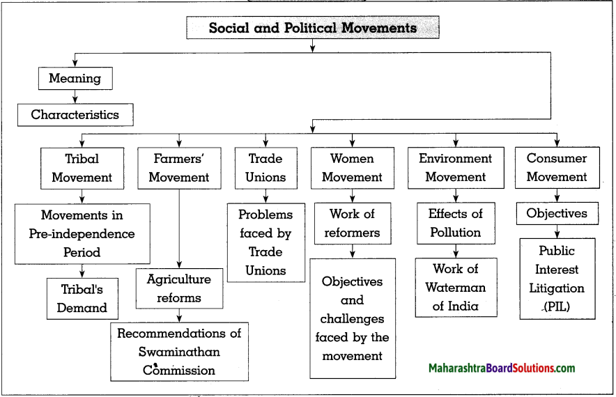
Std 10 Geography Chapter 7 Question Answer Human Settlements Maharashtra Board
Balbharti Maharashtra State Board Class 10 Geography Solutions Chapter 7 Human Settlements Notes, Textbook Exercise Important Questions and Answers.
Class 10 Geography Chapter 7 Human Settlements Question Answer Maharashtra Board
Geography Class 10 Chapter 7 Question Answer Maharashtra Board
1. Tick (✓) the correct options:
Question a.
The concentration of settlements is related to following major factors
(a) Proximity to the Sea
(b) Plain region
(c) Availability of water
(d) Climate
Answer:
(c) Availability of water
Question b.
In North-eastern part of Brazil, which types of settlements are found
(a) Nucleated
(b) Linear
(c) Dispersed
(d) Star-shaped
Answer:
(c) Dispersed
![]()
Question c.
Where do you find dispersed settlements in India?
(i) Near the rivers
(ii) Near the transport routes
(iii) Hilly areas
(iv) Industrial regions
Answer:
(iii) Hilly areas
Question d.
Concentrated settlements are found in Narmada Valley
(i) Forested land
(ii) Cultivable land
(iii) Undulating topography
(iv) Industries
Answer:
(ii) Cultivable land
Question e.
Which state has the least urbanisation in Brazil?
(i) Para
(ii) Amapa
(iii) Espirito Santo
(iv) Parana
Answer:
(i) Para
![]()
2. Give geographical reasons:
Question a.
Availability of water is a major factor affecting settlements.
Answer:
(i) Water is a major factor affecting settlements because water is required for survival of living beings, for purposes like drinking, cooking, agriculture, industries, etc.
(ii) Due to availability of water, agriculture and industries flourish, generating employment opportunities and leading to development of settlements.
(iii) Shortage of water will hamper the growth of agriculture and industries which lead to less development of settlements.
Question b.
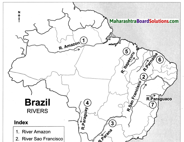
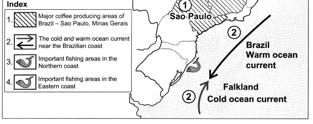
In Brazil, majority of population is found in the eastern coastal areas.
Answer:
(i) Although the coastal climate is hot and humid, and flat land is limited due to rugged topography, the eastern coast of Brazil has a good water supply and a large range of natural resources.
(ii) The region has rich fertile soil which is most suitable for coffee cultivation..
(iii) The region is rich in minerals like iron ore and has a steady power supply.
(iv) An excellent transportation facility is also available here.
(v) Due to these factors, agriculture, industries and trade flourish and settlements increase.
So, majority of Brazil’s population is found in the eastern coastal areas.
Question c.
Urbanisation is increasing rapidly in India.
Answer:
(i) In India, there has been growing industrialisation, leading to availability of jobs in urban areas.
(ii) Urban areas have better facilities and amenities like water supply, electricity, health, education, etc.
(iii) There is increasing migration of people from rural areas to urban areas.
(iv) The urban population is increasing due to the expansion of urban centres and emergence of new towns.
So, urbanisation is increasing rapidly in India.
Question d.
Settlements are sparse in north-eastern Brazil.
Answer:
(i) The north east of Brazil is a Highland.
(ii) As this region lies in a rain shadow region it suffers from droughts.
(iii) Due to scanty rainfall and unavailability of resources, agriculture and industries are not well developed.
(iv) Transport facilities are also very poor here. Therefore, settlements are sparse in north – eastern Brazil.
![]()
Question e.
Except Delhi and Chandigarh, urbanisation is low in other parts of India.
Answer:
(i) Delhi and Chandigarh are union territories lying in the flat Northern Plains of India.
(ii) Delhi is the capital of India and has an ancient history of urbanisation while Chandigarh is one of the most well-planned cities.
(iii) Both Delhi and Chandigarh have good water supply due to river Yamuna and the Bhakra Canal.
(iv) As compared to the other cities in North India, both the cities have well-developed infrastructure, good transport links and other amenities.
(v) Fast developing industries and commercial centres in these places, offer high employment opportunities leading to urbanisation.
Hence, except Delhi and Chandigarh, urbanisation is low in other parts of India.
3. Answer in short:
Question a.
Write a comparative note on urbanisation in Brazil and India.
Answer:
(i) Rate of urbanisation in higher in Brazil than in India.
(ii) Growth of urbanisation in India has been slow.
E.g. From 18% in 1961 to 31.2% in 2011.
(iii) Growth of urbanisation in Brazil has been rapid.
E.g. From 47.1% in 1960 to 84.6% in 2010.
(iv) Urbanisation has been more in the southern part than in the Northern part of India.
(v) Urbanisation in Brazil has been more in the coastal states of south and southeast than the states in the interior of the west and north.
(vi) India’s rate of urbanisation has increased continously in a fluctuating rate.
(vii) Brazil’s is rate of urbanisation has increased but in a diminishing rate.
Question b.
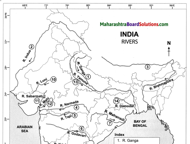
Differentiate between the human settlements in the Ganga river basin and the Amazon river basin.
Answer:
| S.No | Human settlements in the Ganga river basin | Human settlements in the Amazon river basin |
| (i) | Nucleated settlements are found in Ganga river basin. | (i) Dispersed settlements are found in Amazon river basin. |
| (ii) | Flat land, availibality of water, fertile soil,favourable climate is suitable for human settlement. | (ii) Unfavourable climate, heavy rainfall, inaccessibility makes the Amazon river basin unsuitable for human settlement. |
| (iii) | The above conditions along with a good transport network has helped to flourish agriculture and other industries. | (iii) Due to dense evergreen forests and poor transport facility there are restrictions on the use of natural resources, which have affected economic development. |
Question c.
Why do human settlements grow in specific locations only?
Answer:
Human settlements depend on various factors like climate, availability of water, slope of the land, level of development.
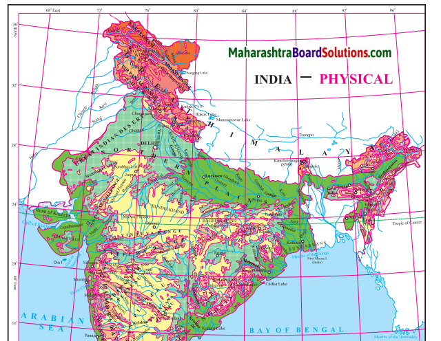
In India, nucleated human settlements are found in the Ganga River Basin because of flat fertile plains, abundance of water, favourable climate and growth of agriculture and industries. Dispersed settlements are found in Himalayan slopes, eastern and southern Rajasthan because of uneven topography, unfavourable climate and lack of development.
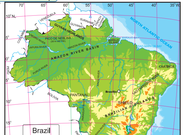
In Brazil, nucleated settlements are found in Sao Paulo and southern coast of Brazil, due to nearness to the ocean, fertile soil, availability of natural minerals like iron ore, steady power supply and good transportation system. Dispersed settlements are found in Northern Brazil due to the inaccessible forests in Amazon river basin, unhealthy climate, limitations on use of natural resources drought region and poor transport connectivity.
Class 10 Geography Chapter 7 Human Settlements Intext Questions and Answers
Geographical Explanation
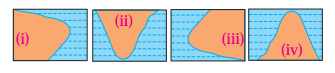
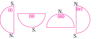
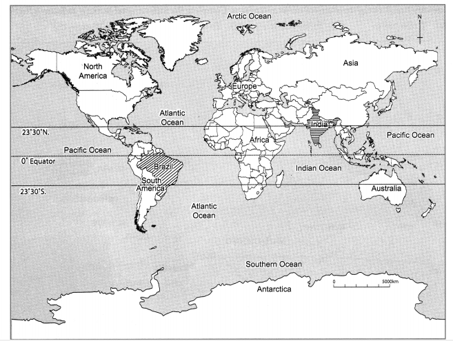
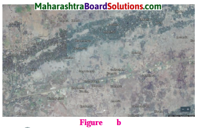
Study the two types of settlement patterns in India given in figure (a) and (b) Answer the following questions :
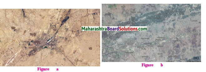
Question 1.
Identify the type of settlements?
Answer:
Fig a. Settlement Type is: Nucleated and in Fig. b. Settlement Type is: Linear and Dispersed settlement.
Question 2.
Which one is a nucleated settlement? Why?
Answer:
Fig. a. Shows the image of a Nucleated settlement, because it is a cultivated land and has a centrally located water body.
Question 3.
Which one is a dispersed settlement? What could be the reason behind it?
Answer:
In Fig. b. dispersed settlement is observed due to unsuitable topography.
Question 4.
Can you guess in which regions are these settlements located in India?
Answer:
Settlement in Fig. a. is located in the north Indian plain, it might be the river Ganga Basin and settlement in the Fig. b. is located in hilly terrain covered with forest and also a road passing through leads to a dispersed settlement.
Think About It
Question 1.
Tell whether settlements shown in images (a) and (b) are urban or rural.
Answer:
The image shown in (a) is urban and The image shown in (b) is rural
![]()
Lets Recall
Question 1.
Some amenities and facilities are given here. Tick (✓) in the relevant column and complete the table on the basis of their presence in urban and rural areas or both.
Answer:
| S.No | Amentity | Available in Villages | Available in Cities |
| (1) | Petrol Pump | ✓ | ✓ |
| (2) | Theatre | ✓ | |
| (3) | Weekly Market | ✓ | |
| (4) | Primary Health Centre | ✓ | |
| (5) | Police Outpost | ✓ | ✓ |
| (6) | Art Gallery | ✓ | |
| (7) | Gram Panchayat | ✓ | |
| (8) | Agricultural Produce Market Committee (APMC) | ✓ | |
| (9) | Primary School | ✓ | ✓ |
| (10) | Senior School | ✓ | |
| (11) | College | ✓ | |
| (12) | Shop | ✓ | ✓ |
| (13) | Multi-speciality Hospital | ✓ | |
| (14) | Metro station | ✓ | |
| (15) | Bus station | ✓ | ✓ |
| (16) | University | ✓ |
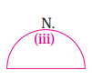
Try This.
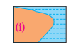
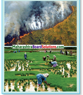
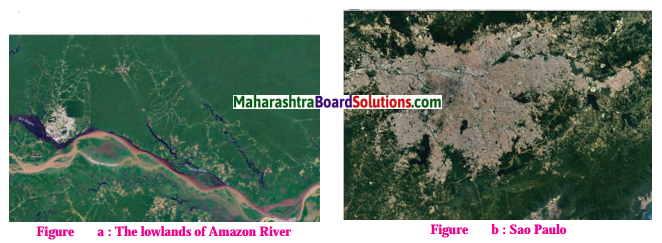
Question 1.
In the figure (a) and (b), you can see images of two settlements in Brazil. One is from the Amazon river basin in Brazil while the other belongs to the coastal area. Observe the settlement patterns carefully and name the types of settlement patterns. Write a comment on their density and types.
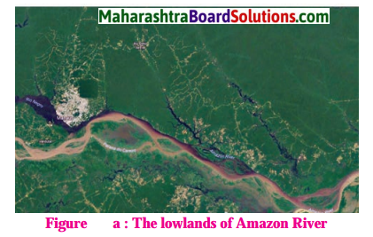
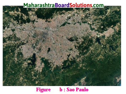
Answer:
(1) Fig. (a)
Type settlement pattern: Dispersed settlements as they are lying in the dense forested areas of the Amazon Basin.
Density of Population: Sparse.
(2) Fig. (b)
Type settlement pattern: Nucleated settlements as they are lying in the dense forested areas of the Amazon Basin.
Density of Population: Dense.
Can You Tell
Read the graph below and answer the following questions:
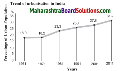
Question 1.
What was the percentage of urbanisation in 1961?
Answer:
The percentage of urbanisation in 1961 was 18%.
Question 2.
In which decade was urbanisation the highest?
Answer:
Highest urbanisation took place in the decade 1971 -1981.
Question 3.
In which decade was the growth of urbanisation lowest?
Answer:
The growth of urbanisation was lowest in the decade 1961-1971.
Question 4.
What was the growth in the percentage of urbanisation between 1961 and 1971?
Answer:
The growth in the percentage of urbanisation between 1961 and 1971 was of 0.20%
![]()
Question 5.
What was the growth in the percentage of urbanisation between 1991 and 2011?
Answer:
The growth in the percentage of urbanisation between 1991 and 2011 was of 5.5%.
Question 6.
What inference can you draw regarding India’s urbanisation after reading the graph?
Answer:
After reading the graph, we can say that urbanisation in India is slowly but continuously rising.
Try This
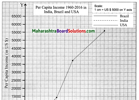
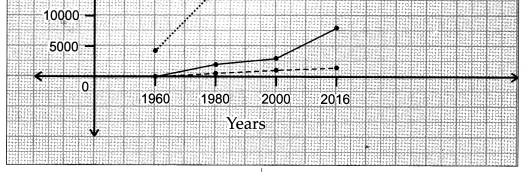
Look at the table. It shows the growth and share of urban population in total population of Brazil. Draw a line graph from this table. Examine the graph carefully and answer the following questions:
Brazil Percentage of urban population (1960 to 2010)
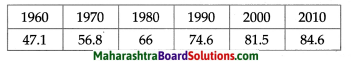
Answer:
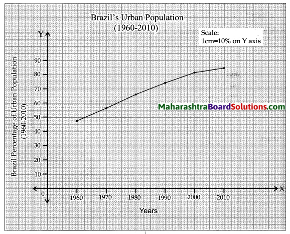
Question 1.
What is the interval of the data?
Answer:
The interval of the data is 10 years.
Question 2.
In which period did urbanisation occur rapidly?
Answer:
Urbanisation occured rapidly in the period 1960 – 1970.
![]()
Question 3.
Write five sentences analysing the graph.
Answer:
(i) The graph shows the percentage of urbanisation in Brazil from 1960 to 2010.
(ii) The interval of the data is 10 years.
(iii) Clearly there has been a rapid urbanisation in Brazil.
(iv) The highest urbanisation is seen between 1960 to 1970, when urbanisation grew from 47.1% to 56.8%, a growth of 9.7%.
(v) Urbanisation occurred slowly during the decade from 2000 to 2010, at a growth of 3.1%.
Give It a Try
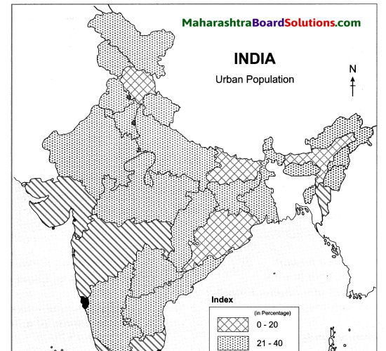
Question 1.
Prepare a choropleth map showing urban population using the data given in the table below.
| S.No. | Urban population percentage category | States /UTs falling in the category |
| (1) | 0-20 | Himachal Pradesh, Bihar, Assam and Odisha |
| (2) | 21-40 | Meghalaya, Uttar Pradesh, Arunachal Pradesh, Chhattisgarh, Jharkhand, Rajasthan, Sikkim, Tripura, Jammu and Kashmir, Nagaland, Manipur, Uttarakhand, West Bengal, Andhra Pradesh, Haryana, A and N Islands, Punjab, Karnataka and M. P. |
| (3) | 41-60 | Gujarat, Maharashtra, Dadra and Nagar Haveli, Kerala, Tamil Nadu, Mizoram |
| (4) | 61-80 | Goa, Puducherry, Daman and Diu, Lakshadweep |
| (5) | 81 -100 | Chandigarh, NCT of Delhi |
Answer:
Colours Of Both
Question 1.
Compare the line graph shown in figure and the one drawn by you for Brazil. Write five lines on the changes that have occurred in urbanisation in both the countries, with time.
Answer:
(i) After comparing the graphs of India and Brazil, it is clear that urbanisation in Brazil has been much more rapid as compared to India.
(ii) Urbanisation in Brazil grew from 47.1% in 1960¬70 to 84.6% in 2000-2010. Whereas urbanisation in India grew from 18% in 1961-70 to 31.2% in 2001-2011.
(iii) But Brazil’s rate of urbanisation is showing signs of decline, whereas India’s rate of urbanisation is showing a slow and consistent growth.
(iv) For e.g. the rate of urbanisation in Brazil has decreased from 9.7% in 1960-1970 to 3.1% in 2000¬2010. Whereas the rate of urbanisation in India has increased from 0.2% in 1961-1971 to 3.4% in 2001-2011.
(v) Both Brazil and India are developing countries, but Brazil shows very high urbanisation as compared to India.
Question 2.
Make a short note on the comparison between the settlement patterns in India and Brazil on the basis of the following points:
(i) Location
(ii) Pattern
(iii) Types
(iv) Density
Answer:
India settlement pattern
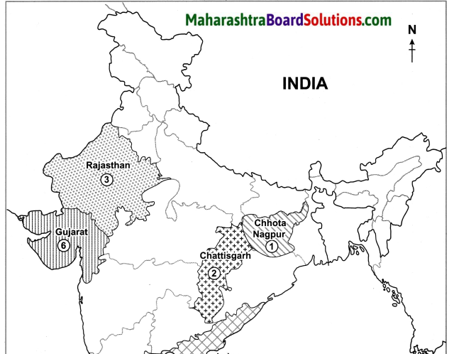
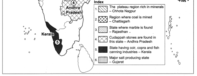
- Location : Nucleated settlements are found throughout the plateau region of Narmada Valley, paddy lands in Bihar, U.P, Vindhyan Plateau and several other cultivated parts of India.
- Pattern : Nucleated settlements
- Types: Urban
- Density : High population density
- Location : Dispersed settlements are found in tribal parts covering central part of India, eastern and southern Rajasthan, Himalayan slopes and land with dissected and uneven topography.
- Pattern : Dispersed settlements
- Types: Rural
- Density : Low population density.
Brazilian settlement pattern
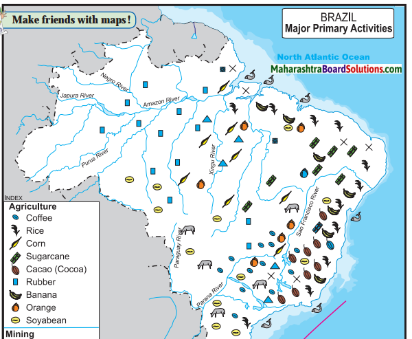
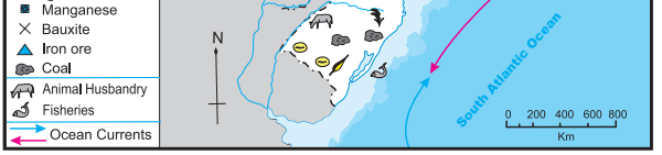
- Location: The Southern and South Eastern parts of Brazil – Areas where there is good water supply, a large range of natural resources, rich soil, large supply of natural minerals, steady energy supply, a good transport system, etc.
- Pattern : Nucleated settlement
- Types: Urban
- Density : High population density.
- Location : Brazilian Highlands, Central part, Amazon Basin region : regions with dense forests, unfavourable climate, poor transport limits, limitations on the use and exploitation of natural resources, etc.
- Pattern : Dispersed settlements
- Type : Rural
- Density: Low population density
![]()
Give It a Try
Question 1.
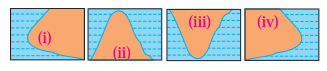
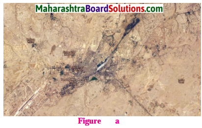
“Observe the two satellite images given below. Describe the settlements with respect to physiography, Considering the physiography, where could these settllements be located? Find out their settlement pattern and limitations with respect to their future growth.
Answer:
(i) Location : Both satellite images show human settlements in a mountainous region. One settlement is along mountain slope, while the other is on top of a mountain.
(ii) Pattern : Dispersed settlements.
(iii) Future growth : Further growth for human settlements seems difficult. This is mainly because of the hilly terrain and forested land along the mountain slope.
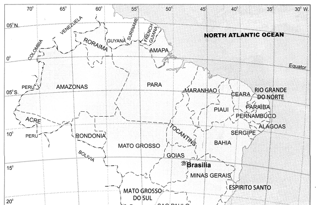
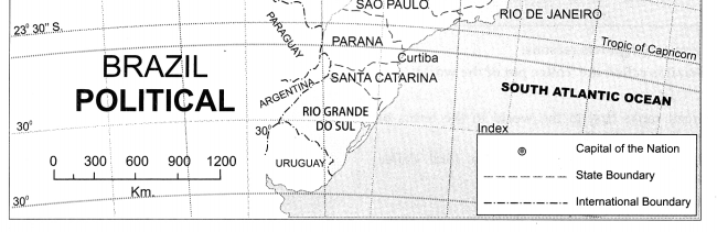
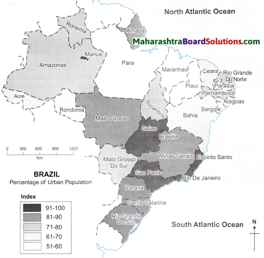
Study the choropleth map of Brazil showing the Statewise urban population of Brazil and answer the following questions :
Question 1.
Which state (region) in Brazil is the most urbanised?
Answer:
The states of Sao Paulo, Rio de Janeiro, Goias, Espirito Santo in the southeastern part of Brazil and the port Manaus in the north are the most urbanised.
![]()
Question 2.
Which state (region) in the least urbanised?
Answer:
The states of Para, Maranhao and Piaui in northern part of Brazil are the least urbanised states.
Use Your Brain Power
Question 1.
Which factors have affected urbanisation in Brazil?
Answer:
(i) In Brazil, rapid urbanisation has taken place in South and South East Coastal regions.
(ii) Being in proximity to the Atlantic Ocean have benefitted these regions immensely in the form of mild climatic conditions.
(iii) Availability of water, fertile soil, natural minerals such as iron ore, good transport system and steady electric supply have positively impacted urbanisation in these parts.
(iv) To the north of the Brazilian Highlands is the rain shadow region of ‘Drought Quadrilateral’ with sparse settlements.
Colours Of Both
Question 1.
Write a paragraph on the settlement pattern, urban and rural settlement and urbanisation in India and Brazil.
Answer:
India settlement pattern
- Location : Nucleated settlements are found throughout the plateau region of Narmada Valley, paddy lands in Bihar, U.P, Vindhyan Plateau and several other cultivated parts of India.
- Pattern : Nucleated settlements
- Types: Urban
- Density : High population density
- Location : Dispersed settlements are found in tribal parts covering central part of India, eastern and southern Rajasthan, Himalayan slopes and land with dissected and uneven topography.
- Pattern : Dispersed settlements
- Types: Rural
- Density : Low population density.
Brazilian settlement pattern
- Location: The Southern and South Eastern parts of Brazil – Areas where there is good water supply, a large range of natural resources, rich soil, large supply of natural minerals, steady energy supply, a good transport system, etc.
- Pattern : Nucleated settlement
- Types: Urban
- Density : High population density.
- Location : Brazilian Highlands, Central part, Amazon Basin region : regions with dense forests, unfavourable climate, poor transport limits, limitations on the use and exploitation of natural resources, etc.
- Pattern : Dispersed settlements
- Type : Rural
- Density: Low population density
![]()
Class 10 Geography Chapter 7 Human Settlements Additional Important Questions and Answers
Choose the correct option and rewrite the statements.
Question 1.
_______ settlements are found in tribal parts covering central part of India.
(a) Nucleated
(b) Linear
(c) Dispersed
(d) Circular
Answer:
(c) Dispersed
Question 2.
The earlier settlements in Brazil were formed by settlers from _______ mainly in coastal areas.
(a) Africa
(b) Asia
(c) Europe
(d) Australia
Answer:
(c) Europe
Question 3.
Sao paulo has _________ settlements.
(a) isolated
(b) nucleated
(c) scattered
(d) dispersed
Answer:
(b) nucleated
Question 4.
Rural areas of Brazil such as the north east highlands suffer from _____ which make it difficult for practising agriculture.
(a) high rainfall
(b) extreme cold
(c) extreme droughts
(d) extreme heat
Answer:
(c) extreme droughts
Question 5.
Settlements become _____ as we go to the central part of Brazil.
(a) sparse
(b) dense
(c) nucleated
(d) triangular
Answer:
(a) sparse
Question 6.
The growth of urbanisation in India has been ________.
(a) quick
(b) moderate
(c) slow
(d) rapid
Answer:
(c) slow
Question 7.
In India, urbanisation has been more in the _______ part.
(a) Western
(b) Eastern
(c) Northern
(d) Southern
Answer:
(d) Southern
![]()
Question 8.
Goa is the most urbanised state in India with _______ urban population.
(a) 92%
(b) 52%
(c) 62%
(d) 82%
Answer:
(c) 62%
Question 9.
_____ is more than 80% urban.
(a) Goa
(b) Gujarat
(c) Delhi
(d) Puducherry
Answer:
(c) Delhi
Question 10.
Today, about ______ of Brazil’s population lives in urban area.
(a) 96%
(b) 66%
(c) 86%
(d) 76%
Answer:
(c) 86%
Question 11.
Looking at the growth in a few parts of the country, the government is promoting “Go _______ ” policy which reduces pressure on other densely populated areas.
(a) East
(b) North
(c) South
(d) West
Answer:
(d) West
Question 12.
Urbanisation has occurred more in the _______ states, in Brazil.
(a) inland
(b) coastal
(c) central
(d) north-western
(b) coastal
Question 13.
_________ is a port on the confluence of the Negro and the Amazon rivers, where urbanisation has occurred.
(a) Alagoas
(b) Parana
(c) Manaus
(d) Ceara
(c) Manaus
Find out the correct group :
Question 1.
States of Brazil in having 91% to 100% urban population.
(a) Sao Paulo, Goias, Espirito Santo and Tocantins.
(b) Espirito Santo, Rio De Janeiro, Para and Goias.
(c) Espirito Santo, Goias, Sao Paulo, Rio De Janeiro.
(d) Sao Paulo, Amapa, Santa Catarina, and Rondonia.
Answer:
(c) Espirito Santo, Goias, Sao Paulo and Rio De Janeiro.
Question 2.
States of India having less than 20% of Urbanization.
(a) Meghalaya, Uttar Pradesh, Arunachal Pradesh and Rajasthan. .
(b) Lakshadweep, Daman and Diu, Puducherry and Nagaland.
(c) Tamil Nadu, Mizoram, Gujarat and Maharashtra.
(d) Odisha, Assam, Bihar and Himachal Pradesh.
Answer:
(d) Odisha, Assam, Bihar, Himachal Pradesh.
![]()
Question 3.
Nucleated settlements in India.
(a) Vindhyan plateau, Plateau region of Narmada valley, Paddy lands in Bihar and Uttar Pradesh.
(b) Rajasthan, Sikkim, Arunachal Pradesh, and Punjab.
(c) Himalayan slopes, East Rajasthan, Tribal part of Madhya Pradesh and Nagaland.
(d) Vindhyan plateau, Paddy lands in Uttar Pradesh, Land with dissected topography and Bihar.
Answer:
(a) Vindhyan plateau, Plateau region of Narmada valley, Paddy lands in Bihar and Uttar Pradesh.
Question 4.
Dispersed settlements in India.
(a) West coast, West Rajasthan, Paddy lands of Punjab and Mizoram.
(b) Land with dissected topography, South Rajasthan, Vindhya plateau and Uttar Pradesh.
(c) Tribal part of Madhya Pradesh, Himalayan slopes, West and South Rajasthan and Land with the uneven topography.
(d) Himalayan slopes, Narmada Valley, West Rajasthan and South India.
Answer:
(c) Tribal part of Madhya Pradesh, Himalayan slopes, West and South Rajasthan and Land with the uneven topography.
Question 5.
States of India having urbanization between 41% to 60%.
(a) Chandigarh, Daman and Diu, Gujarat and Uttar Pradesh.
(b) Maharashtra, Kerala, Gujarat and Mizoram.
(c) Jharkhand, Karnataka, Maharashtra and Goa.
(d) Andhra Pradesh, West Bengal and Uttarakhand, Assam.
Answer:
(b) Maharashtra, Kerala, Gujarat, Mizoram.
Question 1.
Match the columns:
| Column ‘A’ | Column ‘B’ | ||
| (1) | Most urbanised state in India | (a) | Sao Paulo |
| (2) | Most urbanised state in Brazil | (b) | Goa |
| (3) | Least urbanised state in India | (c) | Mato Grosso |
| (4) | Least urbanised | (d) | Himachal Pradesh |
| state in Brazil | (e) | Delhi | |
| (f) | Para | ||
Answer:
1 – b
2 – a
3 – d
4 – f
Are the sentences right or wrong?
Question 1.
India does not have a great tradition of urbanisation.
Answer:
Wrong.
![]()
Question 2.
The earlier settlements in Brazil were formed by the settlers from America.
Answer:
Wrong.
Question 3.
North-East Highlands of Brazil suffer from extreme drought.
Answer:
Right.
Question 4.
The growth of urbanisation in India has been very fast, reaching 86% in 2011.
Answer:
Wrong.
Question 5.
In underdeveloped countries, the rate of urbanisation is low.
Answer:
Right.
Give geographical reasons:
Question 1.
Sao Paulo area has nucleated settlements.
Answer:
(i) Sao Paulo is situated in South East coast of Brazil.
(ii) The region has a good water supply.
(iii) It an extensive area under rich fertile soil which is ideal for growing coffee.
(iv) It has a large supply of natural minerals, such as iron ore.
(v) It also has a steady energy supply.
(vi) This region has a good transport system too.
So, Sao Paulo area has nucleated settlements.
Question 2.
The Brazilian government is promoting ‘Go West’ policy.
Answer:
(i) Brazil is one of the few developing countries which is highly urbanised.
(ii) But urbanisation in Brazil is confined to South and South East.
(iii) For e.g. States like Sao Paulo, Goias, Minas Gerais, Rio De Janeiro have very high urban population.
(iv) Western Brazil continues to remain least urbanised, which is creating regional imbalance.
(v) In order to reduce regional imbalance, the Brazil Government is promoting ‘Go-West Policy’.
Class 10 Geography Textbook Solutions Answers
- Field Visit Class 10 Geography Textbook Solutions
- Location and Extent Class 10 Geography Textbook Solutions
- Physiography and Drainage Class 10 Geography Textbook Solutions
- Climate Class 10 Geography Textbook Solutions
- Natural Vegetation and Wildlife Class 10 Geography Textbook Solutions
- Population Class 10 Geography Textbook Solutions
- Human Settlements Class 10 Geography Textbook Solutions
- Economy and Occupations Class 10 Geography Textbook Solutions
- Tourism, Transport and Communication Class 10 Geography Textbook Solutions