Maharashtra Board Class 11 History Solutions Chapter 12 India, Nations in the Northwest of the Indian Subcontinent and China

Balbharti Maharashtra State Board Class 11 History Solutions Chapter 12 India, Nations in the Northwest of the Indian Subcontinent and China Textbook Exercise Questions and Answers.

Maharashtra State Board Class 11 History Solutions Chapter 12 India, Nations in the Northwest of the Indian Subcontinent and China

1A. Choose the correct alternative and write the complete sentences.

Question 1.
The coin hoards found in ____________ had Roman gold coins in it.
(a) Tamil Nadu
(b) Maharashtra
(c) Karnataka
(d) Kerala
Answer:
(a) Tamil Nadu

Question 2.
The famous king Hammurabi had ruled the kingdom of ____________
(a) Syria
(b) Babylon
(c) China
(d) Greece
Answer:
(b) Babylon

Maharashtra Board Class 11 History Solutions Chapter 12 India, Nations in the Northwest of the Indian Subcontinent and China

Question 3.
The route that links Asia and ____________ is referred as the ‘Silk Route’.
(a) Europe
(b) Africa
(c) America
(d) Russia
Answer:
(a) Europe

Question 4.
‘White Horse Temple is the first Buddhist temple built in ____________
(a) India
(b) Japan
(c) China
(d) Egypt
Answer:
(c) China

1B. Find the incorrect pair from set B and write the correct ones.

Question 1.

Set ‘A’ Set ‘B’
(1) Strabo Geographia
(2) Pliny the Elder Naturalis Historia
(3) Hippalus Hippokura
(4) Arrian Indica

Answer:
(3) Hippalus – Periplus of the Erythrean Sea

1C. Write the names.

Question 1.
A place in the Gandhara region enlisted as a World Cultural heritage.
Answer:
Takht-i-Bahi

Question 2.
Buddhist monks in the 4th century B.C.E. translated many Buddhist texts into the Chinese language.
Answer:
Kumarjeeva

2. Complete the concept maps.

Question 1.
Maharashtra Board Class 11 History Solutions Chapter 12 India, Nations in the Northwest of the Indian Subcontinent and China 2 Q1
Answer:
Maharashtra Board Class 11 History Solutions Chapter 12 India, Nations in the Northwest of the Indian Subcontinent and China 2 Q1.1

3. Explain the following statements with reasons.

Question 1.
Buddhism reached China during the Kushana period.
Answer:

  • The Ancient Kapisha (Begram)was an additional capital of the Kushanas which was located on the silk route at a vantage point.
  • The trade route from Afghanistan to China was under the rule of the Kushanas.
  • This route starting from Taxila crossing through Khyber Pass to Bamiyan in Afghanistan and from there to China through the plateau of Pamir.
  • In the Kushana period, Buddhism reached China by this trade route.

Maharashtra Board Class 11 History Solutions Chapter 12 India, Nations in the Northwest of the Indian Subcontinent and China

Question 2.
The merchants rarely used the shorter line of the Silk Route.
Answer:

  • One of the major lines of the Silk Route linked China and India and then extended further to Central Asia linking one oasis to the other in the desert.
  • It was easier for the merchants and travellers to find accommodation and food in the oasis cities. They also found a ready market for their merchandise.
  • Another line crossed through the stepped to the north of the mainline. The journey on this line is relatively shorter.
  • It was rarely used by merchants as it was infested by troublesome pastoral tribes and hardly have any accommodation and food facilities on route.

4. State your opinion.

Question 1.
There was a close cultural association between the Gandhara region and India before the advent of Islam.
Answer:

  • Gandhara was favourably situated on the trade route that linked India and Central Asia.
  • It had close cultural connections with India from the ancient period of Janapadas till the introduction of Islam.
  • Whether it was the invaders from Central Asia, or the Buddhist monks sent out by Emperor Ashoka, or the Chinese monks traveling to India, all had to pass through Afghanistan.
  • Thus, there were close cultural associations between the Gandhara region and India before the advent of Islam.

5. Write short notes.

Question 1.
Shahji-ki-Dheri
Answer:

  • The Chinese monks like Fa-Hien, Yuan Chwang, who travelled through India have described the Buddhist viharas and stupas in India.
  • There are numerous remains of viharas and stupas in Afghanistan. Among them, a place called ‘Shahji-ki-Dheri’ near Peshawar in Pakistan was excavated.
  • This stupa was built during Kanishka’s period.
  • It is also known as ‘Kanishaka’s Stupa’. According to prevailing tradition, the sacred remains in the box (karandaka) found there are of Gautama Buddha.
  • The box has an inscription. It also mentions the name ‘Agnishala’, the main supervisor of the building work of ‘Kanishka Vihara’.
  • This box is in the Peshawar museum at present.

Question 2.
The Bamiyan Buddhas.
Answer:

  • The Bamiyan Buddhas are in Bamiyan, 250 km away from Kabul.
  • About 750 caves have been hewn out in one of the cliffs of the mountain ranges known as ‘Kuh- e-Baba’.
  • Beautiful murals have been painted inside these caves.
  • The same cliff has niches of two standing Buddha statues in stucco. One of them was 53 meters tall the other was 38 meters.
  • The core was plastered with several layers of mud mixed with straw. The folds of Gautama Buddha’s robes were modeled in this clay plaster.
  • Buddha’s forearms were supported with the help of wooden armatures and fixed with wooden pegs.
  • According to Yuan Chwang, the statues were surrounded by colourful murals and even the statues were painted with gold coating and precious stones.
  • The ‘Bamiyan Statues of Buddha’ are declared as the World Cultural Heritage.

Maharashtra Board Class 11 History Solutions Chapter 12 India, Nations in the Northwest of the Indian Subcontinent and China

6. Answers the following questions with the help of given points.

Question 1.
Write about the ties between ancient India and China.
(a) Trade relations
(b) The spread of Buddhism in China
(c) Serendian art style
Answer:
(a) Trade relations:

  • The Silk Route links Asia and Europe. It runs more than 6000 km.
  • It was easier for Merchants and travellers to find facilities of accommodation and food in the oasis cities.
  • They also found a ready market for their merchandise.
  • Another line crossed through the steppes to the north of this mainline. The journey on this line was relatively shorter.
  • However, it was rarely used by merchants as it was infested by troublesome pastoral tribes and it hardly had any accommodation and food facilities en route.

(b) The spread of Buddhism in China:

  • Buddhism spread in the 1st century C.E. This also introduced a new trend in Chinese art.
  • Many of the Mahayana Buddhist monks who arrived in China hailed from Central Asia.
  • Their presence in China inspired the making of images of Gautama Buddha and Bodhisattva.

(c) Serendian art style:

  • Serendian art style that originated in the Xinjiang province is known as ‘Serendian Art Style’ (Seres meaning China + India).
  • This art was influenced by Gandhara art. It presents a combination of Greek, Persian, and Chinese art forms.
  • Many styles were brought to light during excavations by Sir Aurel Stein.

Maharashtra Board Class 11 History Solutions Chapter 12 India, Nations in the Northwest of the Indian Subcontinent and China

Activity

Collect more information about the ‘Silk Route’ with the help of the internet.
Answer:

  • The Silk Road was a network of trade routes that went along the northern borders of China, India, and Persia and ended up in Eastern Europe near today’s Turkey and the Mediterranean Sea.
  • The Silk Road was important because it helped to generate trade and commerce between a number of different kingdoms and empires.
  • The route included a group of trading posts and markets that were used to help in the storage, transport, and exchange of goods.

Maharashtra Board Class 11 History Solutions Chapter 11 Kingdoms in South India

Balbharti Maharashtra State Board Class 11 History Solutions Chapter 11 Kingdoms in South India Textbook Exercise Questions and Answers.

Maharashtra State Board Class 11 History Solutions Chapter 11 Kingdoms in South India

1A. Choose the correct alternative and write complete sentences.

Question 1.
The name of the well-known king of Vakatak dynasty was ______________
(a) Sarvasena
(b) Pravarasena
(c) Jaising
(d) Chandragupta
Answer:
(b) Pravarasena

Question 2.
After the conquest in South, Pulakeshin II took up the title of ______________
(a) Parameshwara
(b) Vishayapati
(c) Deshadhipati
(d) Satyajay
Answer:
(a) Parameshwara

Maharashtra Board Class 11 History Solutions Chapter 11 Kingdoms in South India

Question 3.
Kalidasa composed ______________ at Ramtek in Vidarbha.
(a) Shakuntal
(b) Meghdoot
(c) Malavikagnimitra
(d) Harivijay
Answer:
(b) Meghdoot

Question 4.
The world famous Kailasa temple was built during the ______________ period.
(a) Chalukya
(b) Pallava
(c) Cher
(d) Rashtrakuta
Answer:
(d) Rashtrakuta

1B. Find the incorrect pair from set B and write the correct ones.

Question 1.

Set ‘A’ Set ‘B’
(a) Setubandh Panini
(b) Harivijay Sarvasena
(c) Indica Megasthenes
(d) Sangit Ratnakar Sharangdev

Answer:
(a) Ashtadhyayi – Panini

2. Explain the following statement with reasons.

Question 1.
A strong rule of the Chalukyas was created in south India.
Answer:

  • The Chalukya dynasty ruled in the south for approximately 200 years.
  • Jaising the founder of this dynasty established his capital at Vatapi (Badami) Pulakeshin I was an important king of this dynasty who performed the Ashwamedha sacrifice.
  • After him, his son Kirtivarman I came to power. During his reign, he conquered the Kadambas of Vanvasi (Karwar) and Mauryas of Aparanta (North Konkan) and expanded his rule.
  • The greatest king of the Chalukyas was Pulakeshin II.
  • He performed the Digvijaya and strengthened the power of the Chalukyas.
  • His achievements are described by Ravikirti, a poet. He defeated Harshavardhan thus, acquiring great fame.

Question 2.
Yadava period has special importance in the history of Maharashtra.
Answer:

  • Yadava dynasty is one of the important dynasties of Medieval Maharashtra.
  • During this period there was a notable development in the cultural sphere of Maharashtra.
  • The Mahanubhav and Warkari sects had a beginning in the Yadava period.
  • During this period, Patan in Khandesh, Solotagi in Karnataka, and Paithan in Maharashtra became important centers of learning.
  • Sanskrit texts were written on subjects like Dharmashastra, ‘Purva Mimansa’ (philosophical text), Nyaya, and Vedanta.
  • Many important texts were composed at this time for eg. the composition of saint poets like Namadeva, Janabai, etc.
  • Many temples were built of the Hemadipanti style at this time.
  • An important feature of the Hemadipanti temples is that no mortar was used.

Maharashtra Board Class 11 History Solutions Chapter 11 Kingdoms in South India

3. Write short notes.

Question 1.
The administrative system in South India
Answer:

  • There were officials like ‘Mahadandanayaka’, ‘Rashtrika’, ‘Deshadhikruta’, ‘Amatya’, ‘Ayukta’, etc.
  • The council of officers in the Chola kingdom was called ‘Udankuttam’.
  • The kingdom was divided into many provinces. These provinces were known as ‘Mandalam’.
  • A member of the royal family was the chief of the Mandalam.
  • There were many officers under him such as ‘Vishayapati’, ‘Deshadhipati’, ‘Deshadhikrut’, ‘Rashtrika’, etc.
  • The administration of the Southern kingdoms was very efficient. Village autonomy was an important feature.
  • The ‘Gramasabha’ (village council) looked after the village administration.
  • The head of the Gramasabha was known by different names such as ‘Gramabhojaka’, ‘Gramakuta’ etc.
  • Land revenue was the main source of income for the state.
  • Apart from it the excise tax, professional tax, pilgrimage tax were the sources of income.

Question 2.
Coins in South Indian dynasties.
Answer:

  • The Maurya coins were in circulation in South India.
  • After the decline of Mauryas, the Pandyas issued their own punch-marked coins.
  • The images like sun, horse, stupa, tree, fish were carved on it.
  • On the Chera coins, there used to be a bow and arrow on one side and an image of an elephant on the other.
  • On the Chola coins, the symbol of the tiger as the royal emblem of Cholas is depicted.
  • The Chola coins were made of gold, silver and the legends were inscribed in the Devnagari script.
  • The coins belonging to Chalukya king Rajaraja are issued in three metals gold, silver, and copper, with the image of Rajaraja and a tiger.
  • Due to the trade with Rome, many Roman coins are found.

4. Answer the following questions in brief with the help of the points given below.

Question 1.
Describe the rule of the Shilahara dynasty
(a) Founder
(b) Shilahara of South Konkan
(c) Shilaharas of North Konkan
(d) Shilaharas of Kolhapur
Answer:
(a) Founder: Jimutvahan is considered to be the founder of all three branches. They ruled for almost three hundred years as the feudatories of Rashtrakutas and later the Chalukyas.

(b) Shilahara of South Konkan: Sanafulla established the South Konkan branch of Shilaharas. His son, Dhammiyar set up the village of Vallipattana and built a fort there. Later King Adityavarma expanded his kingdom from Thane to Goa. Rattaraj was the last ruler of this dynasty. One of the copper plates found at Kharepatan gives an account of the history of this dynasty.

Maharashtra Board Class 11 History Solutions Chapter 11 Kingdoms in South India

(c) Shilaharas of North Konkan: Kapardi established the North Konkan branch of Shilaharas. Their capital was at Sthanak (Thane). Aparajita was an important king of this branch. He ruled for around thirty-five years. He was followed by Chittaraj.

(d) Shilaharas of Kolhapur: The modern districts of Satara, Sangli, Ratnagiri, and Belgaum were included in this kingdom. Jatiga established the Kolhapur branch of Shilaharas. Bhoj II was an important king of this dynasty. Kolhapur, Valivade, and Panhala were the capitals of this kingdom. ‘Koppeshwar Mahadev’ temple at Khidrapur was the creation of Shilaharas.

Activity

Visit the Kailasa temple at Ellora and prepare a detailed note.
Answer:

  • The Kailasa temple is one of the 100 odd rock-cut cave temples and monasteries at Ellora.
  • It is carved from a single, gigantic rock.
  • Lies around 30 km northwest of Aurangabad in Maharashtra.
  • Only 34 are accessible to the public.
  • Ellora or Verul to the locals was located on an ancient South Asian trade.

Maharashtra Board Class 11 History Solutions Chapter 10 Changing Times

Balbharti Maharashtra State Board Class 11 History Solutions Chapter 10 Changing Times Textbook Exercise Questions and Answers.

Maharashtra State Board Class 11 History Solutions Chapter 10 Changing Times

1A. Choose the correct alternative and write complete sentences.

Question 1.
The history of Indo-Greeks is known through their _____________
(a) literature
(b) inscription
(c) coins
(d) pottery
Answer:
(c) coins

Question 2.
Gupta dynasty was founded by _____________
(a) Sri Gupta
(b) Ghatotkach
(c) Samudragupta
(d) Ramgupta
Answer:
(a) Sri Gupta

Maharashtra Board Class 11 History Solutions Chapter 10 Changing Times

Question 3.
After accession by defeating the Shakas _____________ took up the title of ‘Vikramaditya’.
(a) Chandragupta II
(b) Ramgupta
(c) Chandragupta I
(d) Kumaragupta
Answer:
(a) Chandragupta II

1B. Find the incorrect pair from set B and write the correct ones.

Question 1.

Set ‘A’ Set ‘B’
(a) Kshaum Linen Cloth
(b) Pushpaptta Cotton Cloth
(c) Dukul Silk Cloth
(d) Amshuka Muslin Cloth

Answer:
(b) Pushpatta – Floral designs

2. Explain the following statements with reasons.

Question 1.
During the Gupta period, the power was concentrated in the hands of local landlords.
Answer:

  • During the Gupta period, lands were granted to civil and military officers instead of salaries.
  • The roots of the feudal system can be found in this period.
  • It is believed that the feudal economy brought about the decline of urban centers.
  • Because of revenue tax exemption on the donated land, the revenue too decreased and the royal treasury was depleted.
  • It was concentrated in the hands of locals’ landlords. Because of this the king no longer remained in the center of power.

Question 2.
Every tide of the Huna invasion made the Gupta rule weaker.
Answer:

  • During the period of Kumargupta son of Chandragupta II, the Huna in India began.
  • Kumargupta withheld the attacks of Hunas.
  • After Kumargupta, the succeeding kings proved to be incapable of protecting their kingdom.
  • Finally, the Gupta empire disintegrated into many and small kingdoms.

3. State your opinion.

Question 1.
Samudragupta performed the Asvamedha sacrifice after Digvijaya.
Answer:

  • Samudraguptas ambition was to rule entire India as a unified empire.
  • Samudragupta first conquered neighbouring kingdoms.
  • After the conquest in the North, he carried out an expedition in the south to conquer the southern kingdoms. The rulers of the regions beyond this conquered area became his feudatories.
  • He made them accept his suzerainty.
  • After this conquest (Digvijay) Samudragupta performed the Ashwamedha Sacrifice and proclaimed himself as Chakravarti king.

Maharashtra Board Class 11 History Solutions Chapter 10 Changing Times

4. Write short notes.

Question 1.
Gupta Sculptures
Answer:

  • The human figure was the central theme of the sculptures in the Gupta period.
  • Human sculptures and images of deities were created during this period.
  • Sculptures belonging to this period are found at many places such as Sarnath, Devgadh, Ajanta.
  • During this period, Hindu, Buddhist, and Jain religious icons were made of stone, metals, and terracotta.

Question 2.
Indo-Roman trade
Answer:

  • The Periplus of Erythrean Sea written in the mid 1st century C.E mentions the Red sea and the sea routes connecting coastal lines, ports, provinces, goods exchanged in trade.
  • Items like textiles, black pepper, precious stones, ivory, and animals such as monkeys, parrots, and peacocks for entertainment were exported from India.
  • Gold coins were the medium of exchange. Coral and liquor were items of import.
  • A large amount of these gold coins found in south India gives an extent of the trade.
  • The growing trade between Rome and India saw the rise of several markets and cities.
  • Ter, Nevasa, Bhokardan were some of the places where commodities were stored.
  • The port of Sopara and Kalyan were important centers of Indo-Roman trade.

5. Answers the following questions with the help of given points.

Question 1.
How did the standardization in various sections during the Gupta period take place?
(a) Division of Gupta administration
(b) Changes in economic structure economy of agriculture
(c) Development of Gupta coinage.
Answer:
(a) Division of Gupta Administrations:

  • During the Gupta period, the king was the center of administration. The Prince, Amatya (ministers), and advisors helped him. Many times, the prince was appointed as viceroy who looked after the provincial administration.
  • Every province was subdivisions These subdivisions were called Vishaya There was an independent administrator appointed to these Visayas. They were known as ‘Vishayapath’.
  • ‘Kumaramatya’ were the provincial officers and ‘Ayuktak’ were the officials who looked after the affairs of the districts.
  • Gupta’s administration was decentralized. Many decisions were taken.

Maharashtra Board Class 11 History Solutions Chapter 10 Changing Times

(b) Changes in the economic structure, economy of agriculture:

  • The economic structure of the agricultural system was changed by the Gupta kings.
  • They preferred giving land to local farmers for tilling. Land donations were also made for the cause of religion and learning. These lands were tax-free.
  • They were called Agraharas
  • The civil and military officers were granted land grants instead of salaries. Because of revenue tax exemption on the donated land.
  • The power was concentrated on the local landlord
  • Sugarcane and wheat were cultivated in the northwest province of the Gupta empire while the rice was cultivated in Magadha and eastern regions.

(c) Development of Gupta Coinage:

  • Gold Smiths enjoyed a high social status in this period.
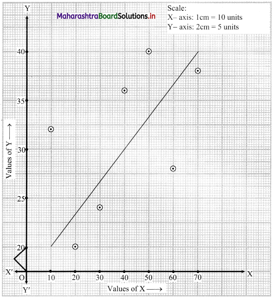
  • The gold coins are excellent examples of their skills.
  • The beautiful and realistic portrayal of various aspects of the king is the characteristic of Gupta Coins.

Activity

Collect more information about ‘Harshacharita’ written by Banabhatta, with the help of the internet.
Answer:

  • ‘Harshacharita’ is a biography of Indian Emperor Harsha by Banabhatta also known as Bana, who was a Sanskrit writer of seventh century C.E., India.
  • This work is in Sanskrit. It has been categorized as an akhyayika (legend), a romanticized yet historical account.
  • Harshacharita has been written in a florid and fanciful style.
  • Bana has in detail and vividly described rural India’s natural environment as well as the extraordinary industry of the Indian people.
  • This work presents the emperor’s actions in an overly favourable light.

Maharashtra Board Class 11 History Solutions Chapter 1 First Farmers

Balbharti Maharashtra State Board Class 11 History Solutions Chapter 1 First Farmers Textbook Exercise Questions and Answers.

Maharashtra State Board Class 11 History Solutions Chapter 1 First Farmers

1A. Choose the correct alternative and write the complete sentences.

Question 1.
“Yellow River” is the English translation of the Chinese name ____________
(a) Kemet
(b) Mother
(c) Sorrow
(d) Huang He
Answer:
(d) Huang He

Question 2.
The Australian archaeologist ____________ coined the term ‘Neolithic Revolution’.
(a) Gorden Willey
(b) Gordon Childe
(c) Herodotus
(d) Collingwood
Answer:
(b) Gordon Childe

Maharashtra Board Class 11 History Solutions Chapter 1 First Farmers

Question 3.
The neolithic people at Gilgal had systematically planted ____________ trees.
(a) guava
(b) sapodilla
(c) fig
(d) Indian blackberry
Answer:
(c) fig

Question 4.
____________ in the Shirur taluka of Pune district is an important site of the village of Chalcolithic farmers in Maharashtra.
(a) Saradwadi
(b) Ranjangaon
(c) Pabal
(d) Inamgaon
Answer:
(d) Inamgaon

1B. Find the incorrect pair from set ‘B’ and write the correct ones.

Question 1.

Set ‘A’ Set ‘B’
(1) The valley of Tigris and Euphrates Mesopotamia
(2) The valley of Nile Iran
(3) The valley of Huang He China
(4) The valley of Sindhu (Indus) and Saraswati Indian Subcontinent

Answer:
(2) The valley of Nile – Egypt

2. Complete the concept maps.

Question 1.
Maharashtra Board Class 11 History Solutions Chapter 1 First Farmers 2 Q1
Answer:
Maharashtra Board Class 11 History Solutions Chapter 1 First Farmers 2 Q1.1

3. Explain the following statements with reasons.

Question 1.
The camps of Mesolithic people developed into the first settled villages of neolithic people in Mesopotamia.
Answer:

  • Mesopotamia is between the two rivers, Tigris and Euphrates.
  • The Mesolithic people began to settle in the region (Mesopotamia) for a longer time, due to the availability of ample water.
  • As both the rivers flooded annually, fertile soil was deposited on their banks.
  • Ample water and fertile soil resulted in camps of Mesolithic people, who developed into the first settled neolithic villages, which grew wheat and barley.

Maharashtra Board Class 11 History Solutions Chapter 1 First Farmers

Question 2.
‘’Huang He’ river is considered to be the mother of the Chinese culture.
Answer:

  • The yellow silt brought by the ‘’Huang He’ river, earns her the name of “Yellow River” in English.
  • The other names ‘River’ and ‘Mother’, indicate her extraordinary place in the Chinese culture.
  • The name ‘River’ indicates her importance as a river.
  • The Chinese culture evolved here, with wheat, foxtail millet, and rice being grown by neolithic farmers in the villages.

Question 3.
In the latter half of the neolithic age, Pottery-making had become an art that required special skills.
Answer:

  • The neolithic pottery, in the beginning, was in monochrome, i.e., single colour with a burnished surface. Pots were polished by rubbing with a wooden or stone tool.
  • Some pots had carved designs, using techniques of stamping and applique work.
  • Gradually Neolithic people began to decorate their pots with painted designs.
  • Thus, in the latter half of the Neolithic age, pottery making had become an art that required special skills.

4. State your opinion.

Question 1.
There were radical changes in the way of human life during the neolithic age.
Answer:

  • In the neolithic age, people lived settled lives with permanently occupied dwellings.
  • The common storage places of food grains indicated that transactions related to food production were centrally controlled.
  • Hierarchical social and family structure and concept of inheritance have their roots in Neolithic times.
  • Pottery making along with polished stone tools is an essential characteristic of neolithic culture.
  • Beads of various types of siliceous stones and chank shells were made, indicating craft specialization and various classes of skilled artisans.

Question 2.
The Neolithic people invented the wheel and the technology they had developed so far, underwent a revolution.
Answer:

  • Neolithic people produced wheel-made pottery.
  • Wheel technology made it possible to produce pottery on a large scale.
  • The invention of the wheel made it possible to obtain raw material from distant places in lesser time.
  • It became easier to send the finished goods to distant markets, where it was in more demand.
  • It helped to develop trade and commerce and transport on a greater scale.

Maharashtra Board Class 11 History Solutions Chapter 1 First Farmers

5. Observe the map on page 2 of your textbook and answer the following questions based on it.

Maharashtra Board Class 11 History Solutions Chapter 1 First Farmers 5

Question 1.
What is the name of the sea on the African continent?
Answer:
The name of the sea on the African continent is the Mediterranean Sea.

Question 2.
In which continent did Harappan civilization originate?
Answer:
The Harappan civilization originated in the Continent of Asia.

Question 3.
What is the name of the ocean in the south of India?
Answer:
The Indian Ocean is the name of the ocean in the south of India.

6. Write short notes.

Question 1.
Neolithic ‘Jericho’
Answer:

  • The Palestinian city of Jericho, on the banks of the River Jordan, is the first neolithic permanent settle’ in 9000 B.C.E.
  • It started getting organized into a well-knit society by about 8000 B.C.E.
  • The village had a protective wall around it, with a watchtower, giving evidence of an organized society.
  • It is proved that cultivation began in Jericho, as discovered at Gilgal a site near Jericho.
  • Laboratory analysis has proved that neolithic people had systematically planted fig cuttings,
  • This stands to be the first attempt at planned cultivation.

Maharashtra Board Class 11 History Solutions Chapter 1 First Farmers

Question 2.
‘Holocene’ epoch
Answer:

  • The last glacial period in the history of our planet came to an end about 12000-11000 years ago.
  • This was the beginning of a new epoch, known as ‘Holocene’.
  • With the beginning of the Holocene, glaciers began to melt, increasing the volume of water in rivers and oceans.
  • As a result, the availability of animals and vegetation for food increased.
  • The period witnessed the extinction of gigantic mammoth.
  • A variety of fishes, small animals like goats, sheep, deer were available for food.

7. Answer the following questions in detail.

Question 1.
Write in detail about the ‘first farmers’ and the beginning of agriculture in India.
Answer:

  • Archaeological sites of Neolithic villages, which have been discovered prove that there were well-settled villages in the Indian subcontinent, as early, as 8000 B.C.E.
  • Historian scholars generally agree that the Harappan cities evolved from these early villages.
  • Barley was the main crop grown by the farmers in these villages, where wheat was grown on a smaller scale.
  • The farmers in these villages were the ‘first farmers’ of the Indian Sub-continent. They lived in mud houses and domesticated cattle and goat-sheep.
  • The transition from hunter-gatherer’s life to the beginning of cultivation spans through 10000¬8700 B.C.E.
  • The beginning of cultivation is also the beginning of the Neolithic age. The period also marked the domestication of animals along with cultivation.
  • While wheat and flaxseeds were grown, barley was the main crop in this period.
  • Modified composite tools like fishing harpoons, spears, and arrows were made. Blades known as microliths and tools like sickle and scythe were used for harvesting cereals and fruits.
Question 2.
What knowledge was essential for the Neolithic people to make pottery?
Answer:

  • The neolithic pottery, in the beginning, was in monochrome (single colour) with a burnished i.e., polished by running with a wooden or stone tool, surface. Some pots had carved designs.
  • The techniques of stamping and applique work i.e., pasting wet clay ribbons and making patterns on them were also used.
  • Painted designs on pots in the latter half of the neolithic age, made pottery art that required special skills.
  • To master the art of pottery-making one needs to possess knowledge of the following things:
    • To know the source of clay of excellent quality.
    • To manage to obtain clay.
    • To knead and prepare the clay for pottery production.
    • To be able to turn the pot to the desired shape.
    • To have artistic skills for decorating the pottery.
    • To know the technique of making pottery at proper temperatures, approximately 850° – 900° Celsius.
  • Pottery helps us to know the cultural history, the material richness of the place, where it was found.
  • With the help of pottery, we can also know about the contacts of the residents of the place with other cultures.

Maharashtra Board Class 11 History Solutions Chapter 1 First Farmers

Question 3.
Write about the trade and transport in the Neolithic age.
Answer:

  • In the latter half of the Neolithic age, people had started using beasts of burden for transporting goods.
  • Tools like axes, scrapers, and chisels enabled neolithic people to cut trees and work on wood.
  • Probably the round-shaped pieces of wooden logs were used as wheels, as they could easily gain momentum.
  • The neolithic people invented the wheel and the technology they had developed so far underwent a revolution.
  • The Neolithic people began to produce wheel-made pottery. The wheel technology made it possible to obtain the raw material from distant places in much lesser time.
  • It became easier to send the finished goods to distant markets where it was more in demand.
  • It helped to develop trade and transport on a greater scale.

Question 4.
Write about the beginning of urbanization in the Neolithic age.
Answer:

  • After settling down at one place for a long time, a feeling of ownership arose among neolithic people.
  • This feeling was focused on their individual dwellings and the piece of land cultivated by them.
  • With social organization and administration, the villages expanded.
  • Along with it, awareness of collective landholdings and the village boundaries became prominent.
  • It was thus felt that the village community had a natural right over the immediate territory around the village periphery.
  • This kind of awareness of natural rights over a particular region is known as ‘territoriality’.
  • Rules and norms were created to manage the collective resources, water sources, crafts dependent on it, trade and community life, etc. Consequently, rituals and their details gained importance.
  • The need of managing and keeping records of trade, rituals, writing, systems, and administrative machinery developed.
  • It gave rise to administrative centers. Such administrative centers attract a large population that includes officials, people from various occupations.
  • As a result, the periphery of the original settlement kept expanding and cities came into being.
  • Thus, began the process of urbanization in the Neolithic age.

Activity (Textbook Page No. 9)

Write in detail about any of the ancient civilizations.
Answer:
Among the ten oldest civilizations in the world, Mesopotamian, Indus Valley, Egyptian and Chinese are well known.
1. The Mesopotamian Civilization:
Mesopotamia is the Greek name of the region between two rivers, Tigris and Euphrates. Meso means the ’middle one’ and Potamos means ’river’. The region between the two rivers is ’Mesopotamia’.

  • Name of the Civilization: Mesopotamian civilization
  • Period: 3500BC-500BC
  • Original Location: Northeast by the Zagros mountains, Southeast by the Arabian Plateau
  • Current Location: Iraq, Syria, and Turkey
  • Meaning: Land between rivers (ancient Greek)
  • Major Highlights:
    • The first civilization in the world.
    • People developed the idea of agriculture and started domesticating animals for both food and farming.

Maharashtra Board Class 11 History Solutions Chapter 1 First Farmers

2. The Indus Valley Civilization:

  • Name of the Civilization: Indus Valley civilization
  • Period: 3300 BC-1900 BC
  • Original Location: Around the basin of the Indus river
  • Current Location: Northeast Afghanistan to Pakistan and northwest India
  • Major Highlights:
    • One of the oldest civilizations in the world.
    • One of the three earliest civilizations along with Ancient Mesopotamia and Egypt.
    • Most widespread covering an area of 1.25million kilometers. Also known as Harappan and Mohenjo-Daro civilization named after the excavation sites where the remains were originally found.
    • A sophisticated and technologically advanced urban culture. This culture was rich in arts and crafts.

3. The Ancient Egyptian Civilization:

  • Name of the Civilization: Egyptian civilization
  • Period: 3150 BC-30 BC
  • Original Location: Banks of the Nile
  • Current Location: Egypt
  • Major Highlights:
    • Construction of Pyramids
    • One of the oldest and culturally rich civilizations and a majestic civilization on the banks of the River Nile is known for its Pharaohs, Pyramids, and the Sphinx.

Maharashtra Board Class 11 History Solutions Chapter 1 First Farmers

4. The Chinese Civilization:

  • Name of the Civilization: The Chinese civilization
  • Period:1600 BC -1046 BC
  • Original Location: Yellow River and Yangtze region
  • Current Location: Country of China
  • Major Highlights:
  • Agriculture in the Neolithic villages of China began around 7000 B.C.E.
  • Wheat, foxtail millet, and rice were grown by farmers in these villages.
  • The invention of paper and silk.

Maharashtra Board Class 11 Geography Solutions Chapter 9 Disaster Management

Balbharti Maharashtra State Board Class 11 Geography Solutions Chapter 9 Disaster Management Textbook Exercise Questions and Answers.

Maharashtra State Board Class 11 Geography Solutions Chapter 9 Disaster Management

1. Identify the correct Alternative.

Question 1.
Which of the following groups shows the correct type of disaster?
Answer:

a b c d
Tectonic Flood Tectonic Tectonic
Geological Geological Geological Human
Human Human Volcanic Biological
Climate Climate Climate Volcanic

Answer:
a

Maharashtra Board Class 11 Geography Solutions Chapter 9 Disaster Management

Question 2.
The Meteorological Department has given information that a cyclone is likely to make a landfall at Odisha in 2 days. Which of the following group shows the correct sequence of management process?

a b c d
Recovery Rehabilitation Preparedness Response
Rehabilitation Preparedness Mitigation Recovery
Preparedness Mitigation Response Rehabilitation
Mitigation Response Recovery Preparedness
Response Recovery Rehabilitation Mitigation

Answer:
c

Question 3.
Statement A – The cyclonic depression originating in the Bay of Bengal is marching towards Tamil Nadu at a velocity of 350 km/hr.
Statement B – The loss of life was not much but property loss occurred on a large scale.
(a) A indicates a disaster and B indicates a hazard.
(b) A indicates a hazard while B indicates a disaster.
(c) A indicates a disaster but B does not indicate a hazard.
(d) A does not indicate a disaster but B indicates a hazard.
Answer:
(b) A indicates a hazard while B indicates a disaster.

Question 4.
India has been successful in mitigation the effects of the following disaster.
(a) Earthquake
(b) Volcanic eruptions
(c) Floods
(d) Cyclones
Answer:
(c) Floods

Maharashtra Board Class 11 Geography Solutions Chapter 9 Disaster Management

2. Write short notes on.

Question 1.
Vulnerability
Answer:

  1. The geographical conditions and circumstances of people or region that make them susceptible to a disaster is known as vulnerability.
  2. People living in certain areas are exposed to particular disasters. Example, in case of a cyclone, people in the coastal areas of India are more likely to be affected than those in the interior.
  3. People living in seismically active areas are prone to earthquakes.
  4. At times, the social, economic and political conditions may make people more likely to be affected by disasters. Example, poor people are more likely to be affected by disaster.
  5. Old people and children can easily become victims of disasters. Densely populated areas are more likely to be affected than sparsely populated areas.
  6. If people are more vulnerable, they have to be better prepared, so that the risk of getting affected by the disaster is less.

Question 2.
Disaster
Answer:

  1. A hazard becomes disaster when it affects human population, settlement and their activities.
  2. When natural events like volcanic eruptions occur in areas inhabited by humans and cause damage, they are termed as disasters.
  3. Disaster causes widespread loss of life and property.

Generally man-made disasters can be prevented as they happen due to mistakes or carelessness by humans.
Disasters can be classified into various types depending on their origin as per following:

  1. Tectonic Disasters : Earthquakes, Volcanic eruptions, Tsunamis.
  2. Geological Disasters : Landslides, Mudslides, Avalanches, etc.
  3. Meteorological Disasters : Floods, Cyclones, Storms, Heat Waves, etc.
  4. Biological Disasters : Locust attacks, Pest attacks, Epidemics, etc.
  5. Anthropogenic or Man-made Disasters: Industrial accidents, Transportation accidents, Nuclear accidents, etc.

Maharashtra Board Class 11 Geography Solutions Chapter 9 Disaster Management

Question 3.
Hazard
Answer:

  1. Hazards are phenomena that pose a threat to people, structural or economic assets and which may cause a disaster.
  2. They could be either naturally occurring in the environment or man-made.
    Example, high rainfall is a hazard as it may cause floods.
  3. A hazard becomes a disaster when it affects human population, settlements and their activities. An earthquake or storm occurring in any area in the world is a hazard but when it occurs in inhabited areas it is called disaster.

Question 4.
Man-made Disasters
Answer:

  1. Disasters can be natural or man-made.
  2. Man-made disasters are also called Anthropogenic disasters. Example, industrial accidents, transportation accidents, nuclear accidents.
  3. The natural disasters cannot be prevented but man-made disasters can be prevented as they happen due to mistakes or carelessness by humans.

3. Write in short.

Question 1.
Mitigation for Cyclone
Answer:

  1. Any measure taken to minimize the impact of a disaster before it occurs is called mitigation.
  2. It is mainly carried out for those disasters which cannot be prevented.
  3. Mitigation for cyclones involve all possible steps taken against potential disaster and reduce the losses.
  4. With the help of satellites, forecasting of cyclones can help in knowing the timing of their landfall.
  5. People can be evacuated from the vulnerable coastal areas.
  6. Thus, mitigation helps the people by creating safer communities and reducing loss of life and property of people.

For example, Effective mitigation measures were taken before the arrival of cyclone Fani in India, Due to proper mitigation measures, there was less financial impact of disaster on government agencies.

Maharashtra Board Class 11 Geography Solutions Chapter 9 Disaster Management

Question 2.
Preparedness for Floods
Answer:
Preparedness involves measures taken to prepare and reduce the effect of disaster. You can
prepare for flooding in a number of ways:

  1. Carry out awareness campaign like warn the people not to come out of the house during flooding.
  2. Ask authorities about relocation centres.
  3. Hospitals should be ready for the treatment of victims.
  4. Prepare an emergency kit.
  5. Prepare a household flood plan.
  6. Keep a list of emergency telephone numbers on display.
  7. Check your insurance policy to see if you are covered for flood damage.
  8. Tell people to be ready with medicines, food, water, etc.
  9. Strengthen the weak structures so that loss of property and life of people will be less.

Question 3.
Rehabilitation after Earthquakes
Answer:

  1. Rehabilitation is the last stage of disaster management.
  2. It tries to restore normalcy in the long term.
  3. It may take many years efforts.
  4. It may include providing housing to the affected people, reconstructions of schools, hospitals, water and gas pipelines, restoring electricity, transport and communication.

4. Answer in detail.

Question 1.
Explain the types of disaster according to origin.
Answer:
Disasters can be classified into various types depending on their origin: They can be of the following types:
1. Tectonic Disasters : Earthquakes, Volcanic eruptions, Tsunamis, etc. Example, in 2004, there was one of the deadliest tsunamis in the Indian Ocean. It affected many surrounding countries like India, Sri Lanka, Thailand, Maldives, Indonesia. Nearly 2,30,210 people were killed.

2. Geological Disasters : Landslides, mudslides, avalanches. Example, Malin landslide of 2014 in Maharashtra, on 7th May 2018, landslides occurred due to heavy rainfall along NH-6 connecting Shillong with Assam, Tripura And Mizoram.

3. Meteorological Disasters : Flood, cyclone, storm, heatwave, etc. Example, in 2008, due to heavy rain, Kosi river was flooded and abruptly changed her course,

4. Biological Disasters : Locust attacks, pest attacks, epidemics, such as flu, dengue, cholera, etc. Example, the 2009 swine flu pandemic.

5. Anthropogenic or Man-made: Industrial accidents, transportation accidents, nuclear accidents, etc. There have been 30 industrial accidents in India, killing 75 workers and injuring over hundred others within two months from May 2020 to July 2020.
Maharashtra Board Class 11 Geography Solutions Chapter 9 Disaster Management

Question 2.
Explain the effects of disasters with the help of examples.
Answer:
The disasters can bring a lot of immediate and long-term effects on various sectors of a society:

  1. Primary effects : They occur as a result of the disaster itself like damage during a flood or collapse of buildings during earthquake. Example, the great Tsunami and earthquake of Indonesia that occurred on 26th December, 2004 or the Malin mudslide of 2014 in Maharashtra.
  2. Secondary effects : They occur because a primary effect has caused them. Example, fires ignited, disruption of electrical power and water service as result of earthquakes.
  3. Tertiary effects : They are long-term effects that are a result of a primary and secondary Effect. Example, like loss of homes, permanent changes in the position of river channel and adverse effect on tourism in an affected area due to an earthquake, etc.

Question 3.
Write about the preparedness in Disaster Management in India.
Answer:
1. India’s geo-climatic conditions and its high degree of socio-economic vulnerability, makes it one of the most disaster-prone country in the world.

2. After the Tsunami in 2004, approach towards disaster management has drastically changed. Various State Governments were requested to set up a disaster management office.

3. At the Government of India level two institutes were set up in New Delhi – the National Institute of Disaster Management (NIDM) and the National Disaster Management Authority (NDMA). The aim was to mitigate the damage potential of natural disasters in future.

4. The disaster management authorities have been established at different levels. At the centre level, the National Disaster Management Authority (NDMA) has been established. At state level, State Disaster Management Authority (SDMA) has been established, at district level, District Disaster Management Authority (DDMA) has been established.

5. The National Crisis Management Committee, also functions at the centre.

6. The nodal ministers are identified for different disaster types of function under the overall guidance of the ministry of Home Affairs (Nodal Ministry for Disaster Management). These ministers interact at different levels within the disaster management framework. Example, for disasters, such as drought, the Ministry for Agriculture is the Nodal Agency.

7. Military forces and para-military forces such as Home Guard, etc., play an important role.

8. Various agencies such as ISRO, NRSC (National Remote Sensing Centre) etc., also play an important role in disaster management.

Question 4.
Explain with example, how will you carry out disaster management in your region or premises?
Answer:
In Mumbai region there is always flooding either due to continuous heavy downpour or due to cyclone. Disaster management can be done in following ways:
Preparedness and mitigation

  1. People be made aware of floods through media. People be warned not to come out of the house during floods.
  2. People should be told to be ready with food, medicines, water, etc.
  3. People can be evacuated from vulnerable areas.
  4. Strengthening of existing building be done.
  5. Hospitals should be ready for the treatment of affected people.

Disaster response

  1. Government and NGOs should supply food, medicines and temporary shelter to affected people.
  2. People should be rescued from affected areas.
  3. Efforts be made to restore normal condition.

Recovery

  1. Giving financial assistance to victims.
  2. Restoration of basic services like transport and repair of physical, economic and social damages.

Rehabilitation

  1. Houses be provided to the affected people.
  2. Rehabilitation of affected farmers and people involved in agriculture and other sectors of economy.
  3. It may also include reconstructions of schools, hospitals, water and gas pipelines, restoring electricity, transport and communication.

Maharashtra Board Class 11 Geography Solutions Chapter 9 Disaster Management

11th Geography Digest Chapter 9 Disaster Management Intext Questions and Answers

Try this.

Read about the following disasters which have occurred across the world and answer the following questions. (Textbook Page No. 97)
Answer:
Maharashtra Board Class 11 Geography Solutions Chapter 9 Disaster Management 1

Question 1.
Classify these disasters into natural and man-made disasters.
Answer:

Natural Disasters Man-made Disasters
Earthquake, Cyclone, Tsunami, Volcanic, eruption, Landslide, Flash Floods, Hailstorm Landslide, Release of Gas Methyl Isocyanate. Rail Accident.

Question 2.
Which of these disasters occurred due to climatic conditions?
Answer:
Bhola Cyclone (India and Bangladesh), Cyclone of Odisha, India; Hailstorm in Maharashtra, India; Cyclone Fani in Odisha, India are disasters that occurred due to climatic conditions.

Question 3.
Which of these disasters occurred due to geological causes?
Answer:
Earthquakes (in China, India, Japan, Pakistan) Ruiz Volcanic Eruption (Colombia), Landslide (Varandha Ghats, Maharashtra, India), Tsunami (India, Indonesia, Sri Lanka) occurred due to geological causes.

Maharashtra Board Class 11 Geography Solutions Chapter 9 Disaster Management

Question 4.
Can you relate the location of a disaster with its cause?
Answer:

  1. Release of gas Methyl Isocyanate during the Bhopal Gas Tragedy in 1984, India, was an Industrial accident caused by human mistake or carelessness.
  2. Tsunami that affected India, Indonesia, Sri Lanka was caused by an earthquake that occurred in the sea-bed off the Indonesian shore.

Question 5.
Besides the number of deaths, what other losses might be occurring after the disasters?
Answer:
Breaching of ghat road, damage to coastal road in the Konkan, many standing crops were destroyed.

Question 6.
Comparing the cyclones of 1999 and 2019, can you think of the reasons behind the reduction in the number of deaths?
Answer:
In the two decades between 1999 and 2019, the capacity to cope with disasters, manage them, the ability of the people and organisations has undergone a huge improvement.

Question 7.
Which of these disasters can be predicted in advance?
Answer:
Cyclones and Tsunamis can be predicted in advance.

Question 8.
Of those disasters for which prediction can be made, can the people be evacuated from the area?
Answer:
Cyclones can be predicted in advance and the people can be evacuated in advance.

Question 9.
Why do some people get affected by the disaster in specific regions?
Answer:
Some people get affected by disasters in specific areas.

  1. In case of a cyclone, people in the coastal areas of India are more likely to be affected than those in the interior.
  2. People living in seismically active regions are prone to earthquakes.
  3. The poor, the old people and children are more likely to be affected by disasters in the same region.
  4. Densely populated areas are more likely to be affected than sparsely populated areas.
  5. Sometimes due to social, economic and political conditions, people are more likely to be affected by disaster in some regions. E.g. poor people are more likely to be affected by disasters.

Can you tell? (Textbook Page No. 99)

If an earthquake occurs with a magnitude of more than 6 in Sahara Desert area which is totally uninhabited by humans and a similar one occurs in Assam, which one would you call a disaster?
Answer:
An earthquake is a hazard but when it occurs in inhabited area, it is called disaster. An earthquake which occurs in Assam can be called a disaster because it is an inhabited area. But an earthquake in Sahara Desert area is not a disaster because it is not inhabited by people.

Maharashtra Board Class 11 Geography Solutions Chapter 9 Disaster Management

Can you do it? (Textbook Page No. 99)

Classify the above components of disaster management into pre-disaster and post-disaster.
Answer:

Pre-disaster Post-disaster
(i) Preparedness (i) Evacuation, search and rescue.
(ii) Monitoring, Early warning and mitigation (ii) Providing relief in terms of medical help, basic needs such as food, clothes and shelter.
(iii) Reconstruction and rehabilitation.

Use your brain power! (Textbook Page No. 100)

Question 1.
In 1988, an earthquake of magnitude 6.9 struck Armenia and took 25,000 lives. On the other hand, an earthquake in 1989 in Californ ia of magnitude 7 took only 63 lives. Can you think of the reason behind this difference?
Answer:
Armenia is densely populated whereas California has a lesser population. Hence, the damage and death caused in Armenia is much higher than that in California.

Question 2.
Why is disaster management called a cycle? See the figure given below. (extbook Page No. 101)
Maharashtra Board Class 11 Geography Solutions Chapter 9 Disaster Management 2
Answer:
The disaster preparedness, mitigation, disaster response, recovery and rehabilitation are the five stages of disaster management which are followed by one after another so it is called disaster management cycle.

Maharashtra Board Class 11 Geography Solutions Chapter 9 Disaster Management

Give it a try. (Textbook Page No. 101)

Given below are a list of measures taken for disaster. Write whether they are pre-disaster or post-disaster and structural or non-structural. Also write the name of the disaster for which they are used. Complete the table.
Maharashtra Board Class 11 Geography Solutions Chapter 9 Disaster Management 3
Answer:
Maharashtra Board Class 11 Geography Solutions Chapter 9 Disaster Management 4

Find out! (Textbook Page No. 102)

Question 1.
Who is responsible for looking after disaster management in our country?
Answer:

  1. The National Disaster Management Authority (NDMA) with the Prime Minister as the Chairperson heads the Disaster Management in our country.
  2. Another institute is National Institute of Disaster Management (NIDM).
  3. Both are located in Delhi.
  4. At the state level, the State Disaster Management Authority (SDMA) is in charge.
  5. There is also the National Crisis Management Committee which also functions at the centre with NDMA and NIDM.
  6. Other agencies are Ministry of Agriculture (disasters such as drought); Military forces and para-military forces like Home Guards.
  7. ISRO, NRSC (National Remote sensing Centre) also play an important role.

Maharashtra Board Class 11 Geography Solutions Chapter 9 Disaster Management

Question 2.
Find out about the role of the military and paramilitary forces in disaster management of India. (Textbook Page No. 103)
Answer:
Military and paramilitary forces evacuate people from the flood-affected areas. They distribute food packets and clothing in the flood-affected areas. They also help in cleaning debris.

Maharashtra Board Class 11 Geography Solutions Chapter 8 Biomes

Balbharti Maharashtra State Board Class 11 Geography Solutions Chapter 8 Biomes Textbook Exercise Questions and Answers.

Maharashtra State Board Class 11 Geography Solutions Chapter 8 Biomes

1. (A) Complete the chain.

Question 1.

A B C
(1) Boreal forest (1) Hardwood species of tree (1) Siberia
(2) Deserts (2) Tropical deciduous forest (2) Myanmar
(3) Teak (3) Wide spectrum of bio-diversity (3) Sahara Desert
(4) Tropical rainforest (4) Tundra region (4) Brazil
(5) Taiga forest (5) Greenland
(6) Narrow spectrum of bio-diversity

Answer:

A B C
(1) Boreal forest (1) Taiga forest (1) Siberia
(2) Deserts (2) Narrow spectrum of bio-diversity (2) Sahara Desert
(3) Teak (3) Tropical deciduous forest (3) Myanmar
(4) Tropical rainforest (4) Hardwood species of tree (4) Brazil

Maharashtra Board Class 11 Geography Solutions Chapter 8 Biomes

(B) Choose the correct option by identifying the correct correlation in the sentences.

Question 1.
Ecosystem consists of interaction between ………………….. and abiotic factors.
(a) biotic
(b) animals
(c) human beings
(d) plants
Answer:
(a) biotic

Question 2.
The original meaning of savannah is ………………….
(a) land with many trees
(b) extensive perennial grassland
(c) land which is full of trees with much grass
(d) land which is without trees but with much grass
Answer:
(b) extensive perennial grassland

Question 3.
In Africa, tropical evergreen forest is predominantly found in ………………….
(a) Amazon basin
(b) Sahara Desert
(c) Congo basin
(d) Savannah
Answer:
(c) Congo basin

Question 4.
Mediterranean forest is also known as ………………… forests.
(a) hardwood
(b) chaparral
(c) manmade
(d) softwood
Answer:
(b) chaparral

2. (A) Arrange the given statements as per given instructions.

Question 1.
Arrange the following biomes in proper order from Equator to Pole.
(a) Tundra
(b) Tropical Rainforest
(c) Boreal forest
(d) Sahara Desert
Answer:
(b), (d), (c), (a)

Maharashtra Board Class 11 Geography Solutions Chapter 8 Biomes

2. (B) Identify the incorrect factor.

Question 1.
Trees in the tropical rainforest
(a) Mahogany
(b) Ebony
(c) Pine
(d) Rosewood
Answer:
(c) Pine

Question 2.
Temperate grassland in the world
(a) Prairies – North America
(b) Steppes – Eurasia
(c) Downs – Africa
(d) Pampas – South America
Answer:
(c) Downs – Africa

Question 3.
Major hot deserts in the world are
(a) Gobi – Asia
(b) Kalahari – Africa
(c) Atacama – South America
(d) Arabian – Asia.
Answer:
(a) Gobi – Asia

3. Give geographical reasons.

Question 1.
The trees in the tropical rainforests are broad-leaved while those in the taiga are coniferous.
Answer:

  1. Tropical rainforest biome has high temperature and heavy rainfall almost throughout the year.
  2. The trees grow very densely and very little sunlight falls on the ground of the forest.
  3. So, plants near the ground have broad leaves to capture as much sunlight as possible.
  4. Such leaves can cope in hot, wet tropical climates because they counteract the day-time heat-trapping effect using transpiration.
  5. The taiga biome has cold winter with severe snowfall. Therefore, to adapt to this condition:
  6. Coniferous trees that grow here have thick bark to protect against the cold.
  7. They are tall, cone-shaped, with flexible branches that taper to the ground and due to their waxy leaves the snow does not stay on the trees.
  8. The pine cones protect the seeds in winter

Question 2.
Desert biomes have thorny vegetation.
Answer:

  1. There is scarcity of rainfall in the desert biomes.
  2. Normally plants lose their moisture through their pores which are present on their leaves and stems.
  3. Desert plants need to avoid the loss of water through these pores to lock in the minimum levels of moisture that they have.
  4. Hence desert plants have leaves which are modified into thorns to control loss of water through transpiration.

Therefore, desert biomes have thorny vegetation.

Maharashtra Board Class 11 Geography Solutions Chapter 8 Biomes

Question 3.
Lumbering activity has developed in Taiga forests.
Answer:

  1. Lumbering is an economic activity involving felling, hauling and logging of timber.
  2. It is well developed in the Taiga coniferous forests because the coniferous forests have soft-wooded trees which are easy to fell with modern machines.
  3. Softwood has great demand in the international market.
  4. The lack of dense undergrowth and creepers help in easy cutting of these trees.
  5. The presence of one type of tree over a large extent, makes commercial lumbering activity more economical.

Hence, lumbering activity has developed in Taiga forests.

Question 4.
Mediterranean biome has proved to be a catalyst to the development of cinema industry.
Answer:

  1. The Mediterranean biome has hot or warm and dry summers and mild or cool and wet winters.
  2. Clear skies, bright sunshine, natural beauty, pleasant climate and flowers have contributed to the development of cinema industry.
  3. Due to clear sky and fine weather outdoor shooting is possible throughout the year.

4. Write short notes on.

Question 1.
Agriculture in temperate grassland biome.
Answer:

  1. The climate of the Temperate Grassland biome is favourable for agriculture and animal rearing.
  2. In grassland regions such as the Prairies, Steppes, Downs, Pampas, Velds, etc., extensive type of agriculture has developed.
  3. Crops like maize, wheat are produced on a large scale.
  4. The fields extend to hundreds of hectares and therefore, advanced machines are used for agriculture.
  5. As these areas have abundant yields, the countries lying in this biome are famous as exporters.
  6. The extent of commercial agriculture is increasing in this area.

Question 2.
Human Life in Tundra biome.
Answer:

  1. Human settlements are very sparse because of very cold climate.
  2. Lapps, Samoyeds and Eskimos live in adverse climate.
  3. Life of Eskimos has changed after they come into contact with westernisers.
  4. As they have started getting advanced instruments, their life and fishing methods have changed. Thus, they have started exploitation of fish at a higher speed in this biome.
  5. Due to increased transportation and means of communication there is lot of development in this region. There is improvement in the standard of living of people.
  6. Due to development there is adverse effect on protected factors of this biome.

Question 3.
Animal adaptation in grasslands.
Answer:

  1. The Tropical Grasslands (Savannah) extend between 10° to 20° N and S.
  2. The abundance of grass cover and its perennial nature have made savannah biomes rich in herbivore animals.
  3. Seasonal change in colour of grass has provided natural shelter for animals.
  4. These grassland supports large number of hoofed animals.
  5. A variety of herbivore animals of different sizes from rabbits to elephants are found here.
  6. With rich herbivore density, these grasslands also support a number of carnivorous animals.
  7. In temperate grassland region soft and juicy grass grows, therefore animal life is rich and varied.
  8. Herbivore animals like zebras, wolves, deer, gazelles and wild horses are found. Coyote is a carnivore.

Maharashtra Board Class 11 Geography Solutions Chapter 8 Biomes

Question 4.
Marine Biomes.
Answer:
The biomes we find in ocean/sea water are called marine biome. Approximately 70% of the earth’s surface is covered by oceans. There are three layers in Marine biomes:
(i) Euphotic Layer:

  1. It is the top layer of the Marine biome.
  2. The sunlight reaches there.
  3. It is around 200 m deep.
  4. It is home to many fishes, sea turtles jellyfish, seals, coral, zooplankton and mangroves.

(ii) Disphotic Layer:

  1. It is the middle layer.
  2. Some light penetrates to the bottom part.
  3. It is about 1000 m deep from mean sea level.
  4. Except few phytoplankton sunk from upper layer, plants are not found here
  5. In this layer animals are adapted to darkness, cold water and high pressure.
  6. Swordfish, eels, sea dragon, cattle fish, squid and wolfish are found.

(iii) Aphotic layer:

  1. It is the deepest layer.
  2. It ranges from 1000 m to 4000 m depth.
  3. No light penetrates here, therefore there is no living plant life in this layer.
  4. Bioluminescent jellyfish, angler fish, hatchet fish, elusive giant squid, etc., are found in this layer.
  5. Beyond this layer lies the darkest and the deepest zone extending up to the sea floor. Here animals are adapted to survive on detritus under even greatest pressure.

5. Differentiate between

Question 1.
Biome and Ecosystem.
Answer:

Biome Ecosystem
(i) An area where different types of flora and fauna live together in the same region in the same type of climatic conditions is called a biome. (i) In a given region, the interaction between biotic and abiotic factors is known as ecosystem.
(ii) The boundaries of different biomes on land are determined mainly by climatic conditions like rainfall, temperature, humidity, amount of insolation received and soil conditions. (ii) The biotic factors are plants, animals and bacteria. The abiotic factors consist of soil, water, sunlight and nutrients.
(iii) There can be many ecosystems in a biome. (iii) There are different trophic levels in an ecosystem.

Question 2.
Tropical and Temperate Grassland Biome.
Answer:

Tropical Grassland Biome Temperate Grassland Biome
(i) It is located between 10° to 20° N and S. (i) It is located between 40° to 55° N and S.
(ii) It is characterised by a continuous cover of perennial grass that grows about 3 m to 6 m height, known as elephant grass and there are a few shrubs and trees. (ii) Grass is a dominant vegetation. It is soft. Not many types of trees are found. The various species of grass include purple needle grass, blue grama, buffalo grass and galleta.
(iii) It is rich in herbivorous animals like rabbits, antelopes, buffaloes, zebras, rhinos, giraffes, elephants, warthogs, etc. It also supports a number of carnivores like lions, leopards, cheetah, wild dogs, jackals, hyenas, and birds like vultures, great Indian bustards, twitter and ostriches. (iii) It is rich and varied in animal life. Herbivore animals include gazelles, zebras, wild horses, wolves, deer, rabbits, etc. In the veld grasslands, ostriches are found. In the Downs of Australia, kangaroos and dingoes are found.

Maharashtra Board Class 11 Geography Solutions Chapter 8 Biomes

Question 3.
Human activities in Tropical Evergreen and Monsoon Regions.
Answer:

Human activities in Tropical Evergreen Human activities in Monsoon Regions
(i) Human life is not very easy in this climate. (i) Human life is easier than that in the rainforest.
(ii) Indigenous humans in these parts are still in their primitive stage. (ii) Primary and secondary occupations based on forests are found here.
(iii) Indigenous tribes are Pygmies in Congo, Boro Indians in Amazon, Sentinels, Onges, Jarawahs, etc., in Andaman and Nicobar Islands in India. (iii) Various tribal communities inhabit the regions under this biome.
(iv) They are engaged in primary activities like gathering of forest products, hunting, fishing, etc. Secondary activities are not developed. (iv) Animal rearing for milk and meat production is carried out. Primary and secondary activities based on forest products are also developed.

6. Answer in detail.

Question 1.
Give an account of the Desert Biome with the help of the following points
(i) Location
(ii) Plant life
(iii) Animal life
(iv) Human life
Answer:
(i) Location: The Tropical Desert biome has the latitudinal extent of 20° to 30° N and S.
(ii) Plant Life : The vegetal life is dispersed. It includes date palms, and thorny trees such as khejari, acacia, and bushes like century plant, cactus, etc. There is hardly any vegetal cover due to the dry climatic conditions.
Characteristics of forests:

  1. Thick leaves with capacity to store water.
  2. Thorny nature reduces speed of evaporation, safety from animals.
  3. Trunk like leaves carry out photosynthesis.

(iii) Animal life:

  1. As the vegetation is sparse, bio-diversity is also limited.
  2. There are relatively few large animals in the desert.
  3. The animals are small and tend to burrow, or stay in hideaways till dusk to avoid the heat. They are adapted to survive in hot climate with very little water.
  4. They are mainly small carnivores, camels, many species of snakes, types of lizards, desert turtles, rats, mongoose along with goats, sheep, donkeys, etc.

Birds : Ostriches, various raptors; guinea fowl and bustards; desert eagle owls and barn owls; sand larks and pale crag martins; and brown-necked and fan-tailed ravens.
Insects : House flies, beetles, moths, types of termites, etc.

(iv) Human life:

  1. The extreme temperatures make human life very difficult here.
  2. Depending on the availability of water, animal husbandry or agriculture might be followed.
  3. Human settlements are found only near oases, in a dispersed pattern. Nomadic life is found in some areas. In the earlier times, Bedouin tribes used to trade by traveling on camels.

Maharashtra Board Class 11 Geography Solutions Chapter 8 Biomes

Question 2.
Explain the reasons behind deforestation in your area. What measures will you suggest to minimize deforestation?
Answer:
I am a resident of Goregaon, very close to the Aarey Colony which was formerly called the Aarey Milk Colony due to the presence of the Aarey Dairy that provided milk to the City of Mumbai. It was once known as the Lungs of Mumbai. It also housed a variety of flora and fauna. But soon deforestation began in phases. First came residential areas, followed by the Film City and now it is the metro car shed. In spite of protests from several citizen’s groups, NGOs and celebrities, more than 2000 trees were felled overnight, forcing the Supreme Court to intervene.

I would suggest the government to shift the metro car shed to some other location and immediately start planting saplings to replace the destroyed trees.

11th Geography Digest Chapter 8 Biomes Intext Questions and Answers

Let us recall.

Look at the fig. 8.1. Answer the following questions (Textbook Page No. 84)

Maharashtra Board Class 11 Geography Solutions Chapter 8 Biomes 1
Question 1.
What does the figure show?
Answer:
The figure shows the vegetation and animal life from equator to polar areas.

Question 2.
What do the numbers on the figure represent?
Answer:
The numbers in the figure represent latitudes.

Question 3.
How does the latitude influence vegetation?
Answer:
Vegetation in any area depend upon the elements of climate such as temperature, rainfall, humidity, soil condition and amount of insolation received. These conditions vary with latitude. For example, in the lower latitudes that is near the equator there is hot and wet climate, so dense evergreen forests grow. But in higher latitudes due to extreme cold climate and heavy snowfall, there are hardly trees but mosses and lichen grow.
Following vegetation grows in different latitudes:
0° to 10° N and S – Dense, evergreen, hardwood forest
5° to 30° N and S – Tropical deciduous forest
10° to 20° N and S – Tropical grasslands
20° to 30° N and S – Tropical Desert.
30° to 40° N and S – Mediterranean (Evergreen and Deciduous Forest)
40° to 50° N and S – Temperate Deciduous Forest.
40° to 55° N and S – Temperate Grasslands.
50° to 55° N – Taiga (Coniferous Forests)
65° to 90° N – Tundra

Maharashtra Board Class 11 Geography Solutions Chapter 8 Biomes

Question 4.
How does Latitude influence the fauna of a place?
Answer:
As the vegetation changes with latitude, depending upon vegetation and climate, fauna also changes as per following.

  1. 0° to 10° N and S – Monkeys, birds from the vulture family, hornbills, parrots, various species of insects, butterflies and reptiles.
  2. 5° to 30° N and S – Microscopic organisms to large elephants, hippopotamus, rhinos, tiger, lion, gaur, monkeys, etc.

Birds : Coucal, hornbills, Asian koel, peacock, vultures, falcon, pigeons, sparrows, etc.
Insects : Ants, butterflies, insects and worms are in plenty.

10° to 20° N and S – Rich in herbivore animals, ranging from rabbits to elephants. Main species – antelopes, buffalo, zebra, rhinos, wild beasts, giraffes, warthogs, etc. The carnivore like cats, lions, leopards, cheetah, wild dogs, jackals, hyenas, etc.
Birds : Vulture, great Indian bustards, twitter and ostriches.

20° to 30° N and S – Mainly carnivores, camels, rats, mongoose, desert turtles, many species of snakes, types of lizards, goats, sheep, donkeys, etc.
Insects : Houseflies, beetles, moths, types of termites, etc.

30° to 40° N and S – Rabbits, deer, goats, pigs, horses, brown bears, fox, berry deer, wild cats, goats and sheep.
Birds : Vultures, eagles.
Alligators, reptiles.
Insects : Various types of insects and honeybees.

40° to 50° N and S – Animals having thick and soft fur like brown bears, red fox, sable, mink, etc. are found.
Birds : Peregrine, falcon, woodpecker, cardinals.
Insects : Many types of insects.

40° to 55° N and S – Rich and varied animal life. Herbivores include gazelles, zebras, wild horses wolves, deer, rabbits, coyote is a carnivore. Ostriches are found in veld grasslands. Kangaroos and dingoes are found in the Downs of Australia.

50° to 55° N – The animals have thick hides and a thick layer of fats and are hairy.
E.g., reindeer, grizzly bears, elk, caribou, etc., are herbivores. Fox mountain lions, puma and panthers are the carnivores.

65° N to 90° N – Very scarce animal life. Thick fur and layer of fats in their body helps them to face very cold climate. Herbivores such as musk ox, bears, reindeer, caribou, lemming, rabbits along with carnivores like Arctic fox, dogs, jackals are found.

Birds : Ptarmigan, ravens, snowy owls and redpolls are found. Majority are migrants. Seals, walruses are found in coastal areas.

Maharashtra Board Class 11 Geography Solutions Chapter 8 Biomes

Question 5.
Which latitude will have more biodiversity?
Answer:
Biodiversity is very high in 0° to 10° N and S and 5° to 30° N and S.

Question 2.
Make a list of products found in your home which have come from this biome. (Textbook Page No. 88)
Answer:
This biome is Tropical Deciduous biome. The wood obtained from the teak tree is used for making furniture. Bamboo is used during painting of buildings. Bamboo products like mats, basket is used in our daily life. We use sandalwood soap, agarbatti as well as paste during pujas and rosewood paste for healing of wounds. We also find in our homes many ayurvedic medicines made from plants of these forests.

Think about it.

Question 1.
Besides latitudes, what other conditions influence the biome? (Textbook Page No. 84)
Answer:
Besides latitudes climate, trophic level, human activities development of agriculture, industries, transportation, tourism etc., also influence the biome.

Question 2.
In which region in India, is desertification occurring? (Textbook Page No. 89)
Answer:
Desertification is occurring in Rajasthan, Delhi, Goa, Maharashtra, Jharkhand, Nagaland, Tripura and Himachal Pradesh.

Question 3.
Why is this type of biome not found in Southern Hemisphere? (Textbook Page No. 93)
Answer:
Taiga biome is from 50° to 55° latitude. There is no landmass from 50° to 55° in southern hemisphere, therefore this type of biome is not found in southern hemisphere.

Maharashtra Board Class 11 Geography Solutions Chapter 8 Biomes

Question 4.
Which activities of human life are affected most by the cold climate? (Textbook Page No. 94)
Answer:
The very cold climate results in sparse human settlements.
It affects human health, the soil and agriculture.
Very cold climate causes thick fog that affects aviation, road, railway and water transport.

Try this.

Question 1.
Find out more differences between an ecosystem and a biome. You can use the following points: scale of area occupied, types, flow of nutrients and energy, examples, etc. (Textbook Page No. 86)
Answer:

Biome Ecosystem
(i) An area where different types of flora and fauna live together in the same region in the same type of climatic conditions is called a biome. (i) In a given region, the interaction between biotic and abiotic factors is known as ecosystem.
(ii) The boundaries of different biomes on land are determined mainly by climatic conditions like rainfall, temperature, humidity, amount of insolation received and soil conditions. (ii) The biotic factors are plants, animals and bacteria. The abiotic factors consist of soil, water, sunlight and nutrients.
(iii) There can be many ecosystems in a biome. (iii) There are different trophic levels in an ecosystem.

Question 2.
Write the names of major countries that lie in this biome. (Textbook Page No. 86)
Answer:
This is Tropical Rainforest biome. The countries in this biome are Brazil, Congo, Ecuador; Indonesia, Peru, Columbia, Bolivia, Gabon, Guyana, India, Laos, Malaysia, Cameroon, Central African Republic, Mexico, Myanmar, Papua New Guinea, Suriname and Venezuela.

Question 3.
Write the names of major countries that lie in this biome. (Textbook Page No. 87)
Answer:
Central India, Bangladesh, Burma, Thailand, Vietnam, Laos, Cambodia, southern part of China and northern part of Australia.

Maharashtra Board Class 11 Geography Solutions Chapter 8 Biomes

Question 4.
Write the names of the major countries that lie in this biome. (Textbook Page No. 88)
Answer:
This is Savannah Grassland biome
Africa : Kenya, Zimbabwe, Botswana, South Africa and Namibia.
Australia, Central America : Belize and Honduras.
South America : Venezuela and Columbia, Southern Asia.

Question 5.
Write the names of the major countries that lie in this biome. (Textbook Page No. 89)
Answer:
This is tropical desert biome. Sahara Desert in North Africa, the Australian Desert of Australia, the Arabian Desert and Syrian Desert in Western Asia, the Kalahari Desert in Southern Africa, Sonoran Desert in the U.S. and Mexico, Mojave Desert in the U.S., Thar Desert in India and Pakistan, Dasht-e-Margo and Registan Desert in Afghanistan and Dasht-e-Kavir and Dasht-e Lut in Iran.

Question 6.
Write the names of major countries that lie in this biome. (Textbook Page No. 90)
Answer:
This is Mediterranean biome. The major countries are Portugal, Spain, southern France, Italy, Yugoslavia, Turkey, Syria, Israel, Lebanon. Northern Africa, central Chile, California in USA, south west Africa and south west Australia.

Question 7.
Write the names of the major countries that lie in this biome. (Textbook Page No. 91)
Answer:
This biome is Temperate Deciduous biome. The major countries are the eastern parts of the United States and Canada, most of Europe and parts of China and Japan.

Read the following news item. (Textbook Page No. 91)

A grizzly bear that killed a mother and her baby in Yukon last fall was emaciated and desperately pursuing unusual food sources at the time of the attack, according to an investigation by the territory’s government. Valerie Theoret, 37, and her 10-month-old daughter, Adele Roesholt, died on Nov. 26, 2018, when a grizzly bear attacked them near their trapping cabin in the remote Einarson Lake area northeast of the village of Mayo. Gordon Hitchcock, chief conservation officer for the Government of Yukon, said the 18-year-old male grizzly bear was emaciated to the point that it was incapable of hibernation.

Additionally, it was in significant and chronic pain from having eaten a porcupine which bears do not typically eat – and had quills penetrating its digestive system from mouth to stomach, “This bear had started turning to uncommon food sources,” said Mr. Hitchcock, who presented findings of a necropsy in Whitehorse on Wednesday. -CNN News

Question 1.
Why do such things occur?
Answer:
Such things occur because man has done encroachment in the habitats of animals. Animals are not getting sufficient food, so they are attacking on human beings.

Maharashtra Board Class 11 Geography Solutions Chapter 8 Biomes

Question 2.
Give examples of such similar incidents in Maharashtra wherein some animal has attacked people in particular region.
Answer:
In Junnar taluka in Pune district, leopard attacked and killed one small girl and goat.

Question 1.
Write the names of the major countries that lie in this biome. (Textbook Page No. 92)
Answer:
The biome is temperate grassland region. The major countries are Prairies in USA and Canada, Steppes in Russia, Downs in Australia, Pampas in Argentina, Veld in south Africa.

Question 2.
Write the names of the major countries that lie in this biome. (Textbook Page No. 92)
Answer:
This is the Taiga biome. The major countries are parts North America, Eurasia, especially Canada and Russia respectively. In Northern Europe, the countries are Finland, Norway and Sweden and spans across Alaska and Scandinavia.

Question 3.
Write the names of the major countries that lie in this biome. (Textbook Page No. 93)
Answer:
This is Tundra biome. The major countries in this Biome are parts of the U.S., State of Alaska and the countries of Canada, Greenland, Iceland, Norway and Russia.

Question 4.
Write the names of the major regions in this biome. (Textbook Page No. 94)
Answer:
This biome is mountain or highland region. The Himalayas in Asia, the Scottish Highlands, the Scandinavian Mountains, American Cordillera in North and South Americas, the Rift mountains of Africa, Carpathian and Pyrenees Mountains in Europe and the Caucasus Mountains.

Can you tell? (Textbook Page No. 86)

Question 1.
A person staying in Sahara Desert and a person staying in Arabian Desert belong to the same biome or ecosystem?
Answer:
Yes, the person staying in Sahara Desert and a person staying in Arabian desert belong to the same biome or ecosystem, since climatic conditions are same. But there may be slight variation depending upon the impact of human activities.

Maharashtra Board Class 11 Geography Solutions Chapter 8 Biomes

Question 2.
(i) The tropical deserts are mainly found in which direction of the continents? What could be the reason behind their formation there?
(ii) In which continent is desert not found? (Textbook Page No. 90)
Answer:
(i) Most of the world’s tropical deserts are located in the western margins of continents in the subtropics because the prevailing winds in the tropics are Tropical Easterly Winds. The Tropical Easterly Winds become dry by the time they reach the western margins of the continents and so they bring no rainfall.

(ii) There is no continent without a desert region. Despite its thick ice, Antarctica is classified as a desert because very little moisture falls from the sky.

Question 3.
In India, where do you find such fruits? What are the reasons for them being found here? (Textbook Page No. 93)
Answer:
The fruits like raspberry, strawberry, blueberry, gooseberry, salmonberry are found in the twin hill towns of Panchgani and Mahabaleshwar because of the cool climate in the summers.

Find out! (Textbook Page No. 86)

Question 1.
Find out the regions in this biome where plantation agriculture has developed.
Answer:
The regions where plantation agriculture is developed are tea plantations in NE India and Indonesia, coffee, cocoa and rubber plantations in Brazil, sugarcane plantations in Java island, rubber plantations in Malaysia and Indonesia, cocoa and coffee plantations in Africa.

Question 2.
Look for the names of the tribes dependent on this biome in India including Maharashtra along with their habitats and show them on a map of India. (Textbook Page No. 87)
Answer:
Major Tribes in India
Maharashtra Board Class 11 Geography Solutions Chapter 8 Biomes 2
Maharashtra Board Class 11 Geography Solutions Chapter 8 Biomes 3

Maharashtra Board Class 11 Geography Solutions Chapter 8 Biomes

Question 3.
Obtain information regarding the tribes inhabiting this biome. Find out about their habitat, lifestyle, conventional ways of living with nature, cultural heritage, etc. (Textbook Page No. 89)
Answer:
This Biome is the Savannah Grassland biome. The Masai is a Nilotic ethnic group.

  1. Habitat : Northern, Central and Southern Kenya and Northern Tanzania, near the game parks of the African Great Lakes.
  2. Lifestyle : Traditionally semi-nomadic lifestyle. They speak ‘Maa’ language. The religions followed are Maasai, Christianity, Islam. They are famous for their fearsome reputation as warriors and cattle-rustlers.
  3. Conventional ways of living with nature : They are basically cattle-rearers, depending on the Savannah grassland for grazing of cattle.
  4. Cultural Heritage : It is strongly patriarchal in nature. Masai worship a single deity called ‘Enkai’ or ‘Engai’. They are known for their intricate jewellery for decades.

Question 4.
Find out the names of countries who produce and export wheat and maize. (Textbook Page No. 92)
Answer:
The countries which produce and export wheat are Canada, USA, European union, Russian federation. The countries which produce and export maize are USA, Argentina, Brazil, Russian federation, and Ukraine.

Maharashtra Board Class 11 Geography Solutions Chapter 7 Indian Ocean – Relief and Strategic Importance

Balbharti Maharashtra State Board Class 11 Geography Solutions Chapter 7 Indian Ocean – Relief and Strategic Importance Textbook Exercise Questions and Answers.

Maharashtra State Board Class 11 Geography Solutions Chapter 7 Indian Ocean – Relief and Strategic Importance

1. Complete the chain.

Question 1.

A B C
(1) Pacific Ocean (1) Christmas (1) Bab-al-Mandeb
(2) Chagos (2) Atlantic Ocean (2) Lakshadweep
(3) Ashmore (3) Maldives (3) Indian Ocean
(4) Hormuz (4) Malacca (4) Cocos

Answer:

A B C
(1) Pacific Ocean (1) Atlantic Ocean (1) Indian Ocean
(2) Chagos (2) Christmas (2) Lakshadweep
(3) Ashmore (3) Maldives (3) Cocos
(4) Hormuz (4) Malacca (4) Bab-al-Mandeb

Maharashtra Board Class 11 Geography Solutions Chapter 7 Indian Ocean - Relief and Strategic Importance

2. Give geographical reasons.

Question 1.
Salinity is less in the Bay of Bengal than in the Indian Ocean.
Answer:
Salinity is less in the Bay of Bengal than in the Indian Ocean because-

  1. The salinity of ocean water is a measure of the concentration of dissolved salts, which are mostly sodium chloride, but also include salts containing magnesium, sulphur, calcium and potassium. It is expressed as parts per thousand (%).
  2. The factors that affect the salinity of ocean water are rate of evaporation and quantitative supply of fresh water (primarily from rainfall and stream discharge) is being added to the ocean.
  3. The average salinity of sea water is 35% But salinity in the Bay of Bengal is as low as 31%.
  4. This is because huge discharge from the Ganga river system, the Peninsular River (Godavari, Krishna, etc.) and Irrawaddy enter the Bay of Bengal, thereby reducing its salinity.

Question 2.
The eastern coastal part of the Indian Ocean is seismically active.
Answer:
The eastern coastal part of the Indian Ocean is seismically active because-

  1. The Andaman Sea is seismically active; it is a part of the Indian Ocean.
  2. The Andaman sea is a part of the Indian Ocean. It is seismically active.
  3. It is one of the most active plate margins in the world that generates frequent earthquakes.
  4. Most of the islands in the eastern part of the Arabian Sea are volcanic islands because they are associated with the converging plate boundary. These islands are peaks of submerged mountains.
  5. The Krakatau volcanic eruption has caused large tsunamis in the past.
  6. Tsunamis have been generated due to earthquakes / volcanic eruption in the Indian region.

Question 3.
Gyre develops in Southern Indian Ocean.
Answer:
Gyre develops in Southern Indian Ocean because-

  1. Gyre is a circular pattern of ocean currents. It is influenced by the shape of the coastline its extent and the peculiar arrangement of the wind system prevailing in the region.
  2. The current system in the southern part of the Indian Ocean leads to the development of a large gyre.
  3. The two major arms of this gyre are:
  4. The south equatorial current flowing east to west direction under the influence of easterlies.
  5. The ‘West Wind Drift’ flowing from west to east under the influence of westerlies.
  6. The circulation is completed in the west by Mozambique-Agulhas currents and in the east by West Australian currents. It is considered to be one of the major gyres on global scale.

Question 4.
Temperatures are high in pre-monsoon season in the equatorial region in northern Indian Ocean.
Answer:

  1. During the pre-monsoon season, when the summer solstice (June 21st) is approaching, the temperatures generally increase, as the sun shines vertically on 23/4 North, Tropic of Cancer.
  2. They are generally much higher in the southern portion closer to the equator. This is the northern portion of the Indian Ocean.
  3. Therefore, temperatures are high in pre-monsoon season in equatorial region in northern Indian Ocean.

Maharashtra Board Class 11 Geography Solutions Chapter 7 Indian Ocean - Relief and Strategic Importance

3. Write short notes on.

Question 1.
The width of continental shelf in the Bay of Bengal and the Arabian Sea
Answer:
The continental shelf in the Bay of Bengal is narrow but the continental shelf in the Arabian sea is very wide.

The river which bring sediments to the continental shelf of the Arabian Sea are short and swift. Therefore, the sediments in the river are deposited in the Continental shelf. The rivers which bring sediments to the continental shelf of the Bay of Bengal are long, sluggish and voluminous, therefore sediments are deposited in deltas and not in the continental shelf.

There are a greater number of estuaries along the coastline of Arabian sea. There are a greater number of deltas along the coastline of the Bay of Bengal.

Question 2.
Mineral resources in the Indian Ocean
Answer:
There are large reserves of hydrocarbons being tapped in the offshore areas of Saudi Arabia, Iran, India and Western Australia. About 40% of the world’s offshore oil production comes from the Indian Ocean.

The beach sands along the coastline of the Arabian Sea is very rich in valuable minerals like uranium, thorium, radium, etc. Beach sands, rich in heavy minerals and offshore deposits are activity exploited by bordering countries particularly India, South Africa, Indonesia and Sri Lanka.

The Abyssal plains of Indian ocean have deposits of polymetallic nodules. These nodules are the source of nickel, copper, manganese and cobalt.

Question 3.
Ocean Currents in the Indian Ocean.
Answer:

  1. The system of the ocean currents in the Indian Ocean is highly influenced by shape of its coastline, its extent, and the peculiar arrangement of the wind system that prevails in the region.
  2. It has the equatorial currents but the north equatorial current is weaker than the south equatorial current.
  3. North of the equator, the currents are influenced by the seasonally reversing monsoon wind system.
  4. The current system in the southern part of the Indian Ocean leads to development of a large gyre.
  5. South equatorial current flowing east to west direction under the influence of easterlies.
  6. The ‘West Wind Drift’ flowing from west to east under the influence of westerlies.
  7. The circulation is completed in the west by Mozambique-Agulhas currents and in the east by West Australian current. It is considered to be one of the major gyres on global scale.
  8. In the northern portion of the Indian Ocean, seasonal Monsoonal winds drive the currents. Mostly, these currents follow along the coastlines.
  9. During summer, they follow in the clockwise direction and during winter, their direction shows a complete reversal and they flow in the anticlockwise direction.

Maharashtra Board Class 11 Geography Solutions Chapter 7 Indian Ocean - Relief and Strategic Importance

Question 4.
Oil and natural gas in the Indian Ocean
Answer:

  1. The oil and natural gas zone are spread across an area of 83,419 sq. km. in the Indian Ocean.
  2. Large reserves of hydrocarbons are being tapped in the offshore areas of Saudi Arabia, Iran, India and Western Australia.
  3. An estimated 40% of the world’s offshore oil production comes from the Indian Ocean.
  4. Offshore deposits of oil and natural gas are actively exploited by bordering countries, particularly India, South Africa, Indonesia and Sri Lanka.

4. Answer in detail.

Question 1.
Outline the importance of the Indian Ocean with respect to trade and transport routes.
Answer:

  1. The Indian Ocean Region connects three continents namely Asia, Africa and Australia.
  2. It supports some of Asia’s biggest economies.
  3. This shows the economic and political significance that the Indian Ocean has.
  4. It contains three busiest straits namely Hormuz, Malacca and Bad-el-Mandeb.
  5. Majority of crude oil exported by Gulf Countries passes through this route via Strait of Hormuz which links the Persian Gulf with the Arabian Sea.
  6. Hence, the Indian Ocean serves as an important route for crude oil supplies worldwide.
  7. The Indian Ocean provides major sea routes connecting the Middle East, Africa and East Asia with Europe and the Americas.
  8. It carries a particularly heavy traffic of petroleum and petroleum products from the oil fields of the Persian Gulf and Indonesia.

Question 2.
Evaluate the strategic location of India with respect to its location in the Indian Ocean.
Answer:

  1. India occupies a central and strategic location in the Indian Ocean area.
  2. India’s national and economic interests are inseparably linked up with the Indian Ocean.
  3. The trans Indian Ocean routes which connect the countries of Europe in the West and the countries of East Asia provide a strategic location to India.
  4. The Deccan Peninsula protrudes into the Indian Ocean, help India establish a close contact with West Asia, Africa and Europe from the western coast and with south east and East Asia on the eastern coast.
  5. India has a long coastline and on the Indian Ocean which becomes favourable for trading ports and commerce hubs for other countries.
  6. The coastal regions of India are famous for agriculture, trade and industrial centres, tourist centres, fishing and salt-making. They provide important hinterlands for the ports.

Maharashtra Board Class 11 Geography Solutions Chapter 7 Indian Ocean - Relief and Strategic Importance

Question 3.
Explain the Indian ocean with respect to following aspects:
(a) Ocean Trenches
(b) Abyssal Plains
(c) ridges
(d) Ocean Currents
Answer:
(a) Ocean Trenches

  1. Trenches are the deepest portions in the oceans.
  2. There are very few deeps and trenches in the Indian Ocean as compared to other oceans.
  3. Most trenches of the Indian Ocean are located towards its eastern boundary.
  4. These are located along the converging boundaries of the Indo-Australian Plate and the Pacific Plate.
  5. The trenches in Indian Ocean are Java or Sunda Trench (7,450m deep) and Ob Trench (6,875m deep).
  6. This area is seismically active because of plate movements.

(b) Abyssal Plains:

  1. Beyond the continental slope, lie the abyssal plains. They have a gentle slope and cover about 66 percent of the oceanic floor area.
  2. Abyssal plains of the ocean have deposits of polymetallic nodules. These nodules are a source of nickel, copper, manganese and cobalt.
  3. India has been allotted an area of 2 million square kilometres for research and excavation of polymetallic nodules by the International Seabed Authority in the Indian Ocean.

(c) Ridges:

  1. Mid Oceanic ridges are submerged mountain ranges that separate deep portions of the sea (ocean) floor.
  2. The Indian Ocean also Has a Mid Oceanic ridge called as a Mid Indian Oceanic ridge.
  3. It originates from the Gulf of Eden near the Peninsula of Somalia.
  4. Further it extends toward the south and on the East side of Madagascar, it gets divided into two branches. Among these, one branch diverts towards southwest and extends up to Prince Edward Island. It is known as Southwest Indian Ocean ridge.
  5. The second branch extends southeast up to Amsterdam and St. Paul Island.
  6. Mid Indian Oceanic Ridge has many parallel ridges. This ridge is not continuous due to many fracture zones in it, such as Owen Fracture Zone, Amsterdam Fracture Zone, etc.

(d) Ocean Currents:

  1. The pattern of currents in the Indian Ocean differs from those in Pacific or Atlantic Oceans.
  2. The monsoon wind system has an effect on the currents in northern Indian Ocean.
  3. The shape of the coastline of the Indian Ocean, its extent, and the peculiar arrangement of the wind system that prevails in the region also influence the system of the ocean currents in the Indian Ocean.
  4. It has Equatorial Currents but the north equatorial current is weaker than the south equatorial current.
  5. North of the equator the currents are influenced by the seasonally reversing monsoon wind system.
  6. The current system in the southern part of the Indian Ocean leads to the development of a large gyre.
  7. South equatorial current flowing east to west direction under the influence of easterlies. The circulation is completed in the west by Mozambique – Agulhas currents.
  8. The second arm is ‘West Wind Drift’ flowing from west to east under the influence of westerlies and the circulation is completed in the east by West Australian current. It is considered to be one of the major gyres on global scale.
  9. In the northern portion of the Indian Ocean seasonal monsoonal winds drive the current. During summer, they follow clockwise direction and during winter, their direction shows a complete reversal and they flow in anticlockwise direction.

5. On an outline map of the world, locate the following and make an index:

1. Sunda Trench
2. Diego Garcia
3. SW Monsoon
4. Agulhas Current
5. West Australian Current
6. Ninety East ridge
7. Strait of Holmuz
8. Chabahar port
Answer:
Maharashtra Board Class 11 Geography Solutions Chapter 7 Indian Ocean - Relief and Strategic Importance 1

Maharashtra Board Class 11 Geography Solutions Chapter 7 Indian Ocean - Relief and Strategic Importance

11th Geography Digest Chapter 7 Indian Ocean – Relief and Strategic Importance Intext Questions and Answers

Make friends with maps! (Textbook Page No. 75)

Look at the figure 7.1 and answer the following questions.

Maharashtra Board Class 11 Geography Solutions Chapter 7 Indian Ocean - Relief and Strategic Importance 2
Question 1.
What does this map show?
Answer:
This map shows the relief of the Indian Ocean floor.

Question 2.
Which continents and sub-continents are visible in this map?
Answer:
The continents of Africa, Antarctica, Australia and the Indian sub-continent are visible in the map.

Question 3.
What lies between the continents?
Answer:
The Indian Ocean and the Southern Ocean lie between the continents.

Maharashtra Board Class 11 Geography Solutions Chapter 7 Indian Ocean - Relief and Strategic Importance

Question 4.
Chagos Plateau, Sunda Trench, Central Mountain range are a part of what?
Answer:
The Chagos plateau is a part of Lakshadweep Plateau.
The Sunda Trench is a part of the Java Trench located in the Indian Ocean near Sumatra, formed where Australian – Capricorn Plates subduct under a part of the Eurasian Plate. The central Mountain Range is a part of Mid Indian Oceanic ridge.

Question 5.
What are the conclusions you can draw after looking at the map?
Answer:

  1. The relief of the ocean floor of the Indian Ocean shows many features.
  2. The Indian Ocean lies mostly in the southern hemisphere.
  3. It is surrounded by the Continent of Africa in the northwest, the Indian sub-continent in the north and north-east, the continent of Australia in the east and the Southern Ocean and the Continent of Antarctica in the south.
  4. The ocean floor has features like the Agulhas plateau, the Madagascar plateau, Chagos and Lakshadweep plateau, and the Kerguelen plateau.
  5. It also has ridges like the Southwest Indian Ocean ridge, the Southeast Indian Ocean ridge and the Mid Indian Ocean ridge.
  6. The other feature are basins like the Agulhas – Natal basin, the Mauritius basin, the Mascarene basin, the Mid-Indian basin, the Ganga basin and the West Australian basin.
  7. The Trenches include Sunda trench.
  8. The Island includes Amsterdam and St. Paul Island and Prince Edward Island.

Find Out! (Textbook Page No. 77)

Why Ninety East ridge name has been given to this ridge?
Answer:

  1. This land form is named as the Ninety East ridge because it is located near the spot where the parallel of latitude strikes along the 90th Meridian at the centre of the eastern hemisphere.
  2. It is one of the important relief features of the Indian Ocean because it divides the Indian Ocean into west and east Indian Ocean.

Maharashtra Board Class 11 Geography Solutions Chapter 7 Indian Ocean - Relief and Strategic Importance

Try This. (Textbook Page No. 78)

Given below are names of some ocean basins in the Indian Ocean. Identify these in figure 7.1. Write a note on their locations, their separators and the rivers entering into them. Rank these according to their size on the basis of your perception.
Maharashtra Board Class 11 Geography Solutions Chapter 7 Indian Ocean - Relief and Strategic Importance 3
(1) Oman basin (2) Arabian basin (3) Somali basin (4) Mauritius basin (5) Mascarene basin (6) Agulhas-Natal basin (7) West Australian basin (8) Mid-Indian basin (9) Ganga basin
Answer:
Maharashtra Board Class 11 Geography Solutions Chapter 7 Indian Ocean - Relief and Strategic Importance 4

Can you do it?

1. Study maps given in the figure 7.2 carefully. These maps are showing the portion of Indian Ocean lying north of equator. Maps in the figure depict the temperature conditions in three seasons: (a) pre-SW monsoon (b) NE monsoon (c) during SW monsoon. Answer the following questions. (Textbook Page No. 78)

Maharashtra Board Class 11 Geography Solutions Chapter 7 Indian Ocean - Relief and Strategic Importance 5
Question 1.
Why are isotherms not drawn on the continental part?
Answer:
The isotherms are not drawn on the continental part because there is summer season and the temperature is high almost everywhere. Since there is no variation in temperature, isotherms are not drawn.

Maharashtra Board Class 11 Geography Solutions Chapter 7 Indian Ocean - Relief and Strategic Importance

Question 2.
Why is the temperature low in Arabian Sea than in Bay of Bengal?
Answer:
The temperature is low in Arabian Sea than in Bay of Bengal due to following reasons-

  1. The salinity of the Arabian Sea is high so it lowers the temperature but the salinity of Bay of Bengal is Low.
  2. The Arabian Sea is open and broad sea compared to Bay of Bengal which is narrow and enclosed by landmasses. There is a lot of movement of ocean water in the Arabian Sea as compared to the Bay of Bengal.

Question 3.
Why is the temperature higher in southern portion of Indian Ocean during pre-SW monsoon?
Answer:
The southern portion of the Indian Ocean is closer to the equator compared to the northern portion of the Arabian Sea. During pre-SW monsoon period, Uttarayan is observed therefore the temperature is high.

2. The given maps are depicting the salinity distribution of northern Indian Ocean. Study the maps (a) NE monsoon (b) pre-SW monsoon (c) SW monsoon given in the figure 7.3 carefully and answer the following questions. (Textbook Page No. 79)

Maharashtra Board Class 11 Geography Solutions Chapter 7 Indian Ocean - Relief and Strategic Importance 6
Question 1.
Why does the Arabian Sea record higher salinity than the Bay of Bengal?
Answer:

  1. The Arabian Sea experiences higher rate of evaporation due to low air humidity, high temperature and lower rainfall.
  2. The number of rivers adding fresh water to the Arabian Sea are fewer in number as compared to the number of long rivers that add fresh water into the Bay of Bengal.
  3. Due to huge discharge from Ganga system and also from long rivers of peninsular India like Krishna. Mahanadi. Cauvery (Kaveri), etc., salinity is low.

This leads to higher salinity in the Arabian Sea as compared to the salinity of the Bay of Bengal.

Maharashtra Board Class 11 Geography Solutions Chapter 7 Indian Ocean - Relief and Strategic Importance

Question 2.
What is the minimum salinity in the Bay of Bengal? In Which seasons do we find it?
Answer:
The minimum salinity in the Bay of Bengal is 30 PSU (Practical Salinity Unit). This occurs in the late autumn and early winter months (November to January) when the East India Coastal Current flows southwards carrying low salinity water.
Question 3.
Account for the high salinity in the Arabian Sea throughout the year?
Answer:

  1. The Arabian Sea experiences higher rate of evaporation due to low air humidity, high temperature and lower rainfall.
  2. The number of rivers adding fresh water to the Arabian Sea are fewer in number as compared to the number of long rivers that add fresh water into the Bay of Bengal.
  3. The rivers joining the Arabian Sea are short and swift so their volume of water is less. As a result, supply of fresh water is less.

This leads to higher salinity in the Arabian Sea as compared to the salinity of the Bay of Bengal.

Do you know? (Textbook Page No. 80)

See the maps in figure 7.4 A and B. They show the pattern of ocean currents in the Indian Ocean during different seasons. Study the maps carefully and answer the following questions.

Maharashtra Board Class 11 Geography Solutions Chapter 7 Indian Ocean - Relief and Strategic Importance 7
Question 1.
Identify the season each map is representing and name them accordingly.
Answer:

  1. Map A shows the summer season condition because in the northern portion of Indian Ocean the Ocean Currents (South Equator Current) flow along the coastlines and flow in the clockwise direction.
  2. Map B shows the winter season condition because in the northern portion of Indian Ocean, the Ocean Currents flow in a complete reverse direction that is in the anticlockwise direction.

Question 2.
What difference do you notice in the direction of currents between winter and summer in Northern Part of the Indian Ocean?
Answer:
In the Northern Part of the Indian Ocean, during summer, the ocean currents flow along the coastlines and flow in the clockwise direction. In the winter season, these ocean currents flow a complete reverse and they flow in anticlockwise directions.

Maharashtra Board Class 11 Geography Solutions Chapter 7 Indian Ocean - Relief and Strategic Importance

Question 3.
How many cold currents are there in the Indian Ocean? Name them.
Answer:
There are four cold currents in the Indian Ocean. The cold currents in the Indian Ocean are the North-East Monsoon Current, Somali Current, West Australian Current and South Indian Ocean Current.

Question 4.
Why do you think the cold currents are fewer in Indian Ocean?
Answer:

  1. The Indian Ocean has land masses of three sizes.
  2. There is varying surface circulation.
  3. There is no arctic contact.
  4. The waters remain between 72° and 82° Fahrenheit across the upper layer. So, there are fewer colder currents in the Indian Ocean.

Question 5.
Which currents maintain the direction in both the seasons?
Answer:
The Mozambique Current, The Equatorial Counter Current, the Agulhas Current and the Australian Current maintain the direction in both the seasons.

Question 6.
Can you see any circulation in the currents of the Indian Ocean? What are such circulations called? If yes, name the currents sequentially.
Answer:
Yes, such circulations are currents called gyre.

  1. The South Equatorial Current flowing east to west direction is under the influence of easterlies.
  2. The ‘West Wind Drift’ flowing from west to east is under the influence of the westerlies.
  3. The circulation is completed in the west by the Mozambique-Agulhas currents and in the east by West Australian Current,

Maharashtra Board Class 11 Geography Solutions Chapter 7 Indian Ocean - Relief and Strategic Importance

Can you tell? (Textbook Page No. 81)

(i) Name the Gulf countries
(ii) In which direction do they lie in the Asian continent?
Answer:
(i) The Gulf countries are Kuwait, Oman, Saudi Arabia, UAE, Qatar and Bahrain. They are called as Gulf countries because they are members of the GCC (Gulf Co-operation Council).
(ii) They lie in the western direction in the Asian continent.

Maharashtra Board Class 11 Geography Solutions Chapter 6 Ocean Resources

Balbharti Maharashtra State Board Class 11 Geography Solutions Chapter 6 Ocean Resources Textbook Exercise Questions and Answers.

Maharashtra State Board Class 11 Geography Solutions Chapter 6 Ocean Resources

1. Complete the chain.

Question 1.

A B C
(1) Continental Shelf (1) Deeper Part (1) Manganese Nodules
(2) Oceanic Microorganisms (2) Abyssal Plains (2) Whales
(3) Oceanic Trenches (3) Fishing (3) Sunda
(4) Vast Flat Area (4) Plankton (4) Dogger Bank

Answer:

A B C
(1) Continental Shelf (1) Fishing (1) Dogger Bank
(2) Oceanic Microorganisms (2) Plankton (2) Whales
(3) Oceanic Trenches (3) Deeper Part (3) Sunda
(4) Vast Flat Area (4) Abyssal Plains (4) Manganese Nodules

Maharashtra Board Class 11 Geography Solutions Chapter 6 Ocean Resources

2. Identify the correct correlation.

A : Assertion
R : Reasoning
Question 1.
A – Continental shelf is a storehouse of mineral oil and natural gas.
R – Continental shelf receives large quantities of load from continental areas.
(a) Only A is correct.
(b) Only R is correct.
(c) Both A and R are correct and R is the correct explanation of A.
(d) Both A and R are correct but R is not the correct explanation of A.
Answer:
(d) Both A and R are correct but R is not the correct explanation of A.

Question 2.
A – More deposition occurs in the continental slope.
R – The slope is steeper here.
(a) Only A is correct.
(b) Only R is correct.
(c) Both A and R are correct and R is the correct explanation of A.
(d) Both A and R are correct but R is not the correct explanation of A.
Answer:
(b) Only R is correct.

Question 3.
A – The islands are actually peaks of submerged mountains.
R – Some peaks of submerged mountains come above the sea level.
(a) Only A is correct.
(b) Only R is correct.
(c) Both A and R are correct and R is the correct explanation of A.
(d) Both A and R are correct but R is not the correct explanation of A.
Answer:
(c) Both A and R are correct and R is the correct explanation of A.

Question 4.
A – The abyssal plains are the deepest parts of the ocean.
R – They lie at the bottom of the ocean.
(a) Only A is correct.
(b) Only R is correct.
(c) Both A and R are correct and R is the correct explanation of A.
(d) Both A and R are correct but R is not the correct explanation of A.
Answer:
(b) Only R is correct.

Maharashtra Board Class 11 Geography Solutions Chapter 6 Ocean Resources

Question 5.
A – Sodium chloride and potassium are parts of inorganic oceanic resources.
R – Salt extraction is a major activity in coastal areas.
(a) Only A is correct.
(b) Only R is correct.
(c) Both A and R are correct and R is the correct explanation of A.
(d) Both A and R are correct but R is not the correct explanation of A.
Answer:
(d) Both A and R are correct but R is not the correct explanation of A.

3. Give geographical reasons.

Question 1.
Fishing has developed in continental shelves.
Answer:
Fishing has developed in continental shelves because-

  1. The portion of the continents that is submerged under water and borders the coastal areas is known as a continental shelf.
  2. They are broad, shallow and gently-sloping plains covered by water.
  3. As the sunlight reaches this part of the ocean bed, plankton grows.
  4. These millions of microscopic organisms found in sea water are an important and favourite food for fish.
  5. Also, the sediments washed from the continental areas add to the food for fish. Thus, millions of fish thrive in this region.

Question 2.
Our knowledge regarding the oceanic trenches is limited.
Answer:
Our knowledge regarding the oceanic trenches is limited because-

  1. At places, deep, narrow and steeply sloping depressions are found on the ocean floor. These are called ocean deeps or ocean trenches.
  2. Generally, the shallow ones are called deeps whereas deeper ones are called ocean trenches. The oceanic trenches are the deepest parts of the oceans.
  3. These trenches can be thousands of meters deep. For example, The Mariana Trench in the Pacific Ocean is around 11 km deep while the Java Trench in the Indian Ocean is around 7.7 km deep.
  4. They generally occur along plate boundaries and are associated with active volcanoes and strong earthquakes.
  5. The knowledge of ocean trenches is limited because of their depth and their remoteness.

Maharashtra Board Class 11 Geography Solutions Chapter 6 Ocean Resources

Question 3.
The ocean is a storehouse of minerals.
Answer:
The ocean is a storehouse of minerals because-

  1. The continental shelves contain the world’s largest reservoirs of natural oil and gas.
  2. The other deposits like diamonds, chromite, ilmenite, magnetite, platinum, gold and phosphorite are also found.
  3. Sand, gravel aggregates and industrial silica sand are the most important of hard minerals now extracted in the near offshore zone.
  4. The abyssal plains are often littered with nodules of manganese containing varying amounts of iron, nickel, cobalt, and copper.
  5. The most common resources obtained from oceans are sodium chloride, i.e., common salt.
  6. A large number of metallic and non-metallic minerals are found on the ocean floor, e.g., potassium occurs in large quantities.
  7. Gypsum forms during evaporation of sea water. The gypsum deposits are mined and converted into Plaster of Paris and used for construction.
  8. The most important minerals extracted from the sea floor are petroleum and natural gas.

Question 4.
Like the land, there are landforms below the ocean too.
Answer:
Like the land, there are landforms below the ocean too because-

  1. Continental shelf is mere continuation of coastal plain, sloping gently, they resemble gently sloping low-lying areas.
  2. As there are plains formed on the surface, similar feature in form of extensive flat land is found on the ocean floor, they are called abyssal plains.
  3. Mountains and ranges are found on the earth’s surface, as seamounts and ridges are found as part of ocean floor. For example, Mid-Indian Ridge.
  4. Some oceanic ridges have flat and extensive tops, they are called oceanic plateaus. For example, Chagos Plateau in the Indian Ocean.
  5. V shaped valleys on the surface of the earth are similar to the deep, narrow and steep sloping depressions, they are called deeps or sea trenches. For example, Kuril Trench in Pacific Ocean in Japan.
  6. Many canyons and gorges are also found on the earth’s surface and in the oceans too.

Maharashtra Board Class 11 Geography Solutions Chapter 6 Ocean Resources

4. Write short notes on.

Question 1.
EEZ
Answer:

  1. Generally, a state’s exclusive economic zone is an area beyond and adjacent to the territorial sea, extending seaward to a distance of no more than 370 km out from its coastal baseline.
  2. The exception to this rule occurs when exclusive economic zones would overlap; that is, state coastal baselines are less than 740 km apart. When an overlap occurs, it is up to the states to delineate the actual maritime boundary.
  3. The exclusive economic zone stretches much further into sea than the territorial water, which ends at 22 km from the coastal baseline if following the rules set out in the UN Convention on the Law of the Sea). Thus, the exclusive economic zones include the contiguous zone.
  4. States also have rights to the seabed of what is called the continental shelf up to 650 km from the coastal baseline, beyond the exclusive economic zones, but such areas are not part of their exclusive economic zones.
  5. The legal definition of the continental shelf does not directly correspond to the geological meaning of the term, as it also includes the continental rise and slope, and the entire seabed within the exclusive economic zone.
  6. The idea of allotting nations with EEZs is to give them more control of maritime affairs outside territorial limits, gained acceptance in the late 20th Century.

Question 2.
Oceanic tourism
Answer:

  1. Ocean tourism is developed along the coastal areas of seas and oceans.
  2. Ocean tourism comes in many forms like cruises, scuba-diving, fishing, beach tourism, etc. Such activities are increasingly becoming popular.
  3. Generally, water sports activities such as scuba diving, surfing, water skiing, etc., are developed along the coastline. For example, sport activities along the coast of Goa.
  4. There is beautiful scenery along the coastline due greenery of trees along the coast, huge waterbody of sea or ocean, clean air and coolness due to nearness to water, therefore many resorts, hotels, marina, etc., are developed and coastal areas have become popular for tourism.

For example, tourism along Konkan coastline. The cruise tourism is also increasing.

Maharashtra Board Class 11 Geography Solutions Chapter 6 Ocean Resources

Question 3.
Abundance of minerals in oceans
Answer:

  1. The continental shelves contain the world’s largest reservoirs of natural oil and gas.
  2. The other deposits like diamonds, chromite, ilmenite, magnetite, platinum, gold and phosphorite are also found.
  3. Sand, gravel aggregates and industrial silica sand are the most important of hard minerals now extracted in the near offshore zone.
  4. The abyssal plains are often littered with nodules of manganese containing varying amounts of iron, nickel, cobalt, and copper.
  5. The most common resources obtained from oceans are sodium chloride i.e. common salt.
  6. A large number of metallic and non-metallic minerals are found on the ocean floor, e.g., potassium occurs in large quantities.
  7. Gypsum forms during evaporation of sea water. The gypsum deposits are mined and converted into Plaster of Paris and used for construction.
  8. The most important minerals extracted from the sea floor are mineral oil and natural gas.

Question 4.
Deposition and Continental Slope
Answer:

  1. After the extent of continental shelf is over, there is a sharp drop in the ocean floor.
  2. The gradient of slope in this region can be between 2° to 5°. This is called continental slope.
  3. The depth of this slope extends from 200 m up to 4000 m from sea level.
  4. Due to its steepness, the continental slope stretches over a limited area.
  5. The deposition of sediments is also limited in this part.
  6. The continental slopes are generally considered as boundaries of continents. Methane hydrate, a compound of water and methane, is present on the continental slopes.
  7. On the slope, we find many traces of submarine landslide activity, ocean canyons and huge avalanche fans. For example, Congo Canyon is a submarine canyon found near Africa.

5. Answer in detail.

Question 1.
The marine pollution is ultimately going to be harmful to the man himself. Discuss.
Answer:

  1. Though the human activities are a major cause behind climate change, there are some natural causes for climate change. They are as follows:
  2. Importance of the ocean is increasing day by day in various ways, human dependence on oceans is likely to increase manifold in the days to come.
  3. Nowadays, the oceanic waters are getting polluted on a large scale.
  4. This causes deterioration of the natural quality of ocean water.
  5. The leakages of oil from oil transporting ships, oil extraction from coastal areas, disposal of solid waste containing radioactive matter, atomic tests etc., are causing large scale pollution of oceanic waters.
  6. The effluents brought by river discharges, the disposal of waste from coastal cities, the waste from industries and many other similar factors are polluting the oceanic waters.
  7. As a result, the very existence of marine life is threatened.

Maharashtra Board Class 11 Geography Solutions Chapter 6 Ocean Resources

Question 2.
There is similarity in the relief on the land surface and the ocean bottom.
Answer:
Ocean tourism is developed along the coastal areas of seas and oceans-
Ocean tourism comes in many forms like cruises, scuba-diving, fishing, beach tourism, etc. Such activities are increasingly becoming popular.

Generally, water sports activities such as scuba diving, surfing, water skiing, etc., are developed along the coastline. For example, sport activities along the coast of Goa.

There is beautiful scenery along the coastline due greenery of trees along the coast, huge waterbody of sea or ocean, clean air and coolness due to nearness to water, therefore many resorts, hotels, marina, etc., are developed and coastal areas have become popular for tourism. For example, tourism along Konkan coastline. The cruise tourism is also increasing.

Question 3.
Discuss how development of oceanic tourism should be carried out without disturbing marine life.
Answer:
It is difficult to clean up mass pollution once it has occurred, so the best plan is prevention. Several changes can take place to help keep industry in check and encourage sustainable practices such as:

  1. Stricter government regulations on industry and manufacturing is one large scale solution. There are several laws to help protect beaches, reduce pollution from ships, reduce marine debris, and prohibit ocean dumping.
  2. Implement renewable energy sources, such as wind or solar power, to limit off-shore drilling.
  3. Limit agricultural pesticides and encourage organic farming and eco-friendly pesticide use.
  4. Proper sewage treatment and exploration of eco-friendly wastewater treatment options, such as recycling sewage sludge to carbon-phosphorous fertilizer, are other solutions.
  5. Cut down on industry and manufacturing waste and contain landfills so they do not spill into the ocean.

Maharashtra Board Class 11 Geography Solutions Chapter 6 Ocean Resources

6. Show the following on the map of the World

1. Chagos Range
2. Mariana Trench
3. Dogger Bank
4. Mumbai High
5. Sunda Deep
6. Grand Banks
Answer:
Maharashtra Board Class 11 Geography Solutions Chapter 6 Ocean Resources 1

11th Geography Digest Chapter 6 Ocean Resources Intext Questions and Answers

Use your brain power! (Textbook Page No. 68)

Collect information of the following and discuss in the class:

  1. Major journeys carried out by explorers in the last millennium
  2. Discovery of continents, countries and islands
  3. Spread of culture, trade and religions

Comment on how oceans have played a major role in all the three points mentioned above.
Answer:
[Students will find out the journeys and expeditions and comment on it in their own words.]

Try this.

1. Look at figure 6.1 and answer the following question. (Textbook Page No. 68)

Question 1.
What does the figure show?
Answer:
The figure shows various landforms of the ocean floor.

Question 2.
In which part of the figure is the ocean shallow? Which human activities can be carried out here?
Answer:
The ocean is shallow at the continental shelf area. Fishing is carried out here as a major human activity.

Question 3.
In which part does deposition of sediments occur?
Answer:
Deposition of sediments occur on the continental shelf area as well as on the abyssal plains.

Question 4.
Where in the figure do you find islands formed due to submerged mountains?
Answer:
Islands formed due to submerged mountains are found in the oceanic ridges and plateau region.

Question 5.
Label the figure with correct names of landforms.
Answer:
Maharashtra Board Class 11 Geography Solutions Chapter 6 Ocean Resources 2

Question 6.
Compare these features with the landforms on the earth.
Answer:
On the earth, different types of mountains and ranges are found, as they are found on the sea floor in the form of sea mounts and ridges, islands. Similarly, on the earth’s surface plains are formed as abyssal plains, which are found on the sea floor. Valleys and canyons on the earth’s surface represent oceanic deeps and trenches as a part of ocean floor.

2. Various institutes are presently working for exploration of ocean, its climate, resources and its impact on our lives. Prepare a list of such institutes which are in India. With the help of internet, complete the table below. (Textbook Page No. 72)
Answer:
Maharashtra Board Class 11 Geography Solutions Chapter 6 Ocean Resources 3

3. Do you know that India has got the right to mine manganese nodules from the bed of the Indian Ocean from that area which lies beyond the exclusive economic zone. Identify some other resources which are international in nature. (Textbook Page No. 73)
Answer:
India can mine Cobalt and Nickel from the Indian Ocean from the area which lies beyond the EEZ.

Find out! (Textbook Page No. 70)

Question 1.
Find out the name and locations of islands located in India and list them in the above given categories.
Answer:

  1. Continental Islands: Minicoy, Seven Islands of Bombay (Bombay is the present-day Mumbai.), Sundarbans, Amindivi, etc.
  2. Volcanic Island: Barren island part of Andaman and Nicobar Islands
  3. Coral Island: Andaman and Nicobar, Gulf of Kutch, Gulf of Mannar, Lakshadweep, Tarkarli in Malvan, etc.

Question 2.
India also produces water from desalination plants. Find out their locations with the help of the internet.
Answer:
The Minjur Desalination Plant is the largest in India, located at Kattupalli village, a northern suburb of Chennai on the coast of the Bay of Bengal that supplies water to the city of Chennai.

Maharashtra Board Class 11 Geography Solutions Chapter 5 Global Climate Change

Balbharti Maharashtra State Board Class 11 Geography Solutions Chapter 5 Global Climate Change Textbook Exercise Questions and Answers.

Maharashtra State Board Class 11 Geography Solutions Chapter 5 Global Climate Change

1. Complete the chain.

Question 1.

A B C
(1) Melting of snow (1) Increase in sea level (1) Flooding
(2) Effects of insolation (2) Erratic rains (2) Increase in frequency of cyclones
(3) Greenhouse gases (3) Methane (3) Agriculture
(4) Climate change (4) Average temperature of the earth (4) Existence of life on Earth

Answer:

A B C
(1) Melting of snow (1) Methane (1) Flooding
(2) Effects of insolation (2) Average temperature of the earth (2) Agriculture
(3) Greenhouse gases (3) Erratic rains (3) Existence of life on Earth
(4) Climate change (4) Increase in sea level (4) Increase in frequency on cyclones

Maharashtra Board Class 11 Geography Solutions Chapter 5 Global Climate Change

2. Identify the incorrect factor.

Question 1.
The causes of global warming-
(a) Emission of greenhouse gases
(b) Deforestation
(c) Apparent movement of the sun
(d) Industrialization
Answer:
(c) Apparent movement of the sun

Question 2.
The indicators of climate change-
(a) Retreat of glaciers
(b) Increase in the frequency of floods
(c) Increase in frequency of cyclones
(d) Increase in the minimum and maximum temperature
Answer:
(d) Increase in the minimum and maximum temperature

Question 3.
The tools for studying climate change
(a) Ice cores
(b) Coral reef
(c) Tree rings
(d) Ancient forts
Answer:
(d) Ancient forts

Question 4.
Measures to combat climate change –
(a) Banning the use of pesticides and insecticides
(b) Promoting afforestation and banning deforestation
(c) Banning public transport
(d) Banning fossil fuels
Answer:
(c) Banning public transport

3. Give geographical reasons.

Question 1.
It is important to study climate change.
Answer:
It is important to study climate change because –

  1. The earth’s climate is changing faster primarily as a result of human activities.
  2. Number of flash floods are increasing, especially in urban areas.
  3. Due to warming of oceans the rate of evaporation is high, which is the root cause of both flooding and droughts.
  4. Due to increase in temperature, there is melting of snow on mountains and sea level is rising.
  5. Human activities, especially emissions of heat-trapping greenhouse gases from fossil fuel combustion, deforestation and land use changes are the primary drivers of the climate changes observed in the industrial era.

Maharashtra Board Class 11 Geography Solutions Chapter 5 Global Climate Change

Question 2.
There is a great possibility that we may not see Maldives on the world map in the future.
Answer:
There is a great possibility that we may not see Maldives on the world map in the future because-

  1. Sea level continues to rise at a rate of about 3 mm/ per year, leaving no ground surface higher than 3 m.
  2. Due to global warming the rising of sea level is likely to worsen.
  3. Higher sea levels may lead to severe cyclones and periodic flooding of coastal areas.
  4. Since, Maldives is a flat country there is possibility that it may be submerged under sea water if the rise in sea level continues.

Question 3.
The snowline is retreating.
Answer:
The snowline is retreating because –

  1. A snowline is a boundary between a snow-covered and snow-free surface. Above the snowline there is permanent snow cover.
  2. When glaciers and icebergs melt at an alarming rate, it is a cause of concern. This is known as retreating glaciers.
  3. Due to changes in the climate there is less snowfall as compared to the previous years.
  4. This means that there is lesser ice formation each year than its rate of melting.
  5. Thus, due to melting of glaciers and icebergs as well as less snowfall the snowline is retreating.

Question 4.
There is an increase in the frequency of droughts and cyclones.
Answer:
There is an increase in the frequency of droughts and cyclones because-

  1. In addition to triggering more rainfall, global warming could also increase the occurrence of drought.
  2. The roots of both flooding and drought lie in the physical process known as evaporation.
  3. As global warming heats the world’s oceans, the water molecules near the sea surface become more energetic and tend to evaporate into the atmosphere more readily. Thus, water vapour is formed.
  4. Similarly, due to global warming, the number of cyclones in a year and their intensities have also increased in the tropical regions.

4. Write short notes on.

Question 1.
Bleaching of coral reefs
Answer:

  1. When temperature changes, corals throw out the algae living in their tissues.
  2. These algae are responsible for their colour.
  3. An increase of 1°C – 2°C in ocean temperatures for a long time can lead to bleaching, turning corals white.
  4. If corals are bleached for prolonged periods, they eventually die.
  5. Coral bleaching leads to death of large amounts of corals.

Maharashtra Board Class 11 Geography Solutions Chapter 5 Global Climate Change

Question 2.
Flash floods
Answer:

  1. A flash flood is a term that describes floods, which is usually observed in the low-lying areas.
  2. Floods are caused due to extremely heavy rainfall.
  3. Flash floods generally occur after the collapse of natural ice, debris dam or a man-made dam, etc.
  4. Flash foods also occur due to very high precipitation in one day (Mumbai in 2005, Kedarnath in 2013) or because of changed weather conditions like cyclones (Chennai, 2015).
  5. Flash foods are different from the regular floods by having a time scale of fewer than six hours between rainfall and the onset of flooding.

Question 3.
Tools to study Paleoclimatology
Answer:
Paleoclimatology is the study of the weather and climate of the earth’s past. Scientists and meteorologists have been using instruments to measure climate and weather for the past 140 years. However, millions of years ago historical evidence called proxy data, which includes coral reefs, tree rings, ice cores, etc., were used to tell about the climate.

Coral reefs:

  1. Coral reefs are very sensitive to changes in climate. –
  2. Corals form skeletons by extracting calcium carbonate from the ocean waters.
  3. When the water temperature changes, densities of calcium carbonate in the skeletons also change.
  4. Coral formed in the summer has a different density than coral formed in the winter.
  5. This creates seasonal growth rings on the corals.
  6. Scientists can study these rings to determine the temperature of the water and the season in which the coral grew.

Tree rings:

  1. There are rings on the stem of the tree.
  2. Variation in these rings is due to variation in the environmental conditions when they were formed.
  3. Thus, studying this variation leads to improved understanding of past environmental conditions.

Ice cores:

  1. These are samples of ice taken from the inner sides of the ice sheets.
  2. Throughout each year, layers of snow fall over the ice sheets in Greenland and Antarctica.
  3. Each layer of snow is different.
  4. Summer snow differs from winter snow.
  5. Each layer gives scientists a lot of information about the climate each year.

Question 4.
Greenhouse gases
Answer:

  1. Greenhouse gases are the primary gases, such as, water vapour carbon dioxide, nitrous oxide, methane and ozone in the earth’s atmosphere that absorbs and traps energy from the sun.
  2. Of all greenhouse gases, carbon dioxide absorbs more heat.
  3. Without greenhouse gases, the average temperature of the earth’s surface would be about -18°C rather than the present average of 14°C.
  4. Carbon dioxide emissions comes from many human activities such as combustion of fossil fuels, oil and natural gas, with additional contributions coming from deforestation, changes in land use, soil erosion and agriculture (including live stock).

Maharashtra Board Class 11 Geography Solutions Chapter 5 Global Climate Change

5. Answer in detail.

Question 1.
Climate change has not always been anthropogenic in nature. Explain.
Answer:
Though the human activities are a major cause behind climate change, there are some natural causes for climate change. They are as follows:
Amount of energy output by the sun:

  1. Low energy output by the sun can reduce amount of insolation received by the earth.
  2. This can lead to cooling of the earth.

Milankovitch Oscillation:

  1. The earth’s rotation around its own axis and revolution around the sun is responsible for the changes in climate.
  2. Their changes alter the amount of insolation received from the sun, which in turn might affect its climate.
  3. It can cause the earth to be closer to the sun (warmer) and farther from the sun (colder).
  4. The ice ages can occur when we are farther from the sun.

Volcanism:

  1. Volcanic eruptions throw lots of particulates and aerosols into the atmosphere.
  2. These aerosols remain in the atmosphere for a considerable period of time.
  3. The winds spread it around the world, thus reducing the sun’s radiation reaching the earth’s surface.

Goldilocks Zone:

  1. The earth lies in the habitable zone called the Goldilocks Zone.
  2. Earth experiences cooler climate, when it was located in the outer reaches of this zone.
  3. As the size of the sun increases the zone moves outward over time.
  4. Such changes in the zone causes earth to warm or cool.

Maharashtra Board Class 11 Geography Solutions Chapter 5 Global Climate Change

Question 2.
What measures will you suggest to combat climate change in your village/city.
Answer:
Following measures can be taken to combat climate change in our village / city.

  1. Afforestation should be encouraged in and around play areas, hill sides, schools, etc.
  2. Deforestation should be avoided strictly.
  3. The use of public transport should be enabled to lessen the vehicular pollution. Thus, emission of harmful gases such as CO2, etc., can be prevented.
  4. Use of natural manure can be encouraged instead of using fertilizers.
  5. In villages, Liquefied Petroleum Gas (LPG) should be used instead of using coal or wood as fuel.

11th Geography Digest Chapter 5 Global Climate Change Intext Questions and Answers

Can you tell? (Textbook Page No. 58)

1. The graph in the figure shows the difference between the global average temperature of the twentieth century and global monthly temperatures from 1985 to 2015. Answer the questions given below.
Maharashtra Board Class 11 Geography Solutions Chapter 5 Global Climate Change 1

Question 1.
In which year is the difference the least?
Ans.
Difference in the temperature is least in the year 1985.

Question 2.
What is the difference between the mean temperatures of the twentieth century and temperature in 2015?
Answer:
The difference between the mean temperature of twentieth century (1995-2000) and 2015 is 0.8°C.

Question 3.
Why do the temperatures differ in different months?
Answer:
The temperature differs in different months because of the occurrence of different seasons.

Maharashtra Board Class 11 Geography Solutions Chapter 5 Global Climate Change

2. Look at the graph and answer the questions. (Textbook Page No. 63)
Maharashtra Board Class 11 Geography Solutions Chapter 5 Global Climate Change 2

Question 1.
What does this graph show?
Ans.
The graph shows CO2 concentration (ppm) and its increased level over the period of time from 1900 to 2017.

Question 2.
What does ppm mean?
Answer:
The abbreviation ppm means ‘parts per million’ of carbon concentration in the atmosphere.

Question 3.
Since which year has the increase been phenomenal?
Answer:
After 1980, there has been a phenomenal increase observed.

Question 4.
Can you think of the reasons behind the increase in carbon dioxide?
Answer:
The reasons behind the increase in carbon dioxide is due to combustion of fossil fuels and large- scale deforestation.

Try this. (Textbook Page No. 59)

1. Look at the following graph. Answer the following question.
Maharashtra Board Class 11 Geography Solutions Chapter 5 Global Climate Change 3

Question 1.
Which of these gases has the highest contribution?
Answer:
Water vapour, shows the highest contribution.

Maharashtra Board Class 11 Geography Solutions Chapter 5 Global Climate Change

Question 2.
Which of these gases came from natural and man-made sources?
Answer:
Water vapour, methane, NO2 and miscellaneous gases are naturally occurring gases while CO2 is man-made.

Question 3.
Which activities are responsible for their emission?
Answer:
Burning of fossil fuels like coal, etc., and deforestation are responsible for emission of CO2.

Question 4.
Out of these, whose emission can be controlled by humans?
Ans.
The emission of CO2 can be controlled by humans.

Question 2.
Make a list of things you need to change in your lifestyle. (Textbook Page No. 67)
Answer:

  1. Use of public transport.
  2. Less use of wood but more use of alternatives to wood.
  3. Regular maintenance of vehicles.
  4. Avoid wastage of water.
  5. Use of energy efficient devices.
  6. Ban on plastic goods.
  7. Minimum use of paper in home and office.
  8. Purchase of only required goods.
  9. Use of Eco-friendly goods.
  10. Celebration of festivals without harming the environment.

Find out! (Textbook Page No. 62)

Question 1.
Use internet and reference books on climate change and make a list of species vulnerable to climate change.
Answer:
Species vulnerable to climate change are: corals, polar bear and frogs.

Maharashtra Board Class 11 Geography Solutions Chapter 5 Global Climate Change

Question 2.
Make a list of movies based on ice age and climate change. (Textbook Page No. 65)
Answer:

  1. Interstellar
  2. Beasts of the Southern Wild
  3. Chasing Coral
  4. Snowpiercer
  5. An Inconvenient Truth
  6. Are you ready to fight? (Vattaram)

Question 3.
With the help of internet, find out the details of the National Action Plan on Climate Change (NAPCC), 2008 and its missions. (Textbook Page No. 66)
Answer:
NAPCC is a government document that includes eight ambitious goals set for the country to achieve.

  1. National Solar Mission
  2. National Mission for Enhanced Energy Efficiency
  3. National Mission on Sustainable Habitat
  4. National Water Mission
  5. National Mission for Sustaining the Himalayan Ecosystem
  6. National Mission for a “Green India”
  7. National Mission for Sustainable Agriculture
  8. National Mission on Strategic Knowledge for Climate Change

1. Look at the graph and answer the following questions. (Textbook Page No. 60)

Maharashtra Board Class 11 Geography Solutions Chapter 5 Global Climate Change 4
Question 1.
What does the graph show?
Answer:
The graph shows an increase in the global sea level from 1880 till date.

Question 2.
In which year is the change around 225 mm?
Answer:
The change around 225 mm is observed is the year 2018.

Question 3.
What conclusions can you draw by seeing the graph?
Answer:
With the continued global warming the sea levels are likely to rise.

Maharashtra Board Class 11 Geography Solutions Chapter 5 Global Climate Change

Question 4.
What correlation can be seen in this graph and the graph of rising temperature?
Answer:
With the rising temperature the sea level is rising. We can conclude this from both the graphs.

Question 2.
Compare both the satellite images in fig 5.3 (A) and (B). (Textbook Page No. 61)
Maharashtra Board Class 11 Geography Solutions Chapter 5 Global Climate Change 5
Answer:
Fig. 5.3 (A) shows the snow-covered Gangotri glacier area in Dec. 1984, whereas in Fig. 5.3 (B) the snow-covered region of the Gangotri glacier has retreated by 2018.

Maharashtra Board Class 11 Geography Solutions Chapter 4 Climatic Regions

Balbharti Maharashtra State Board Class 11 Geography Solutions Chapter 4 Climatic Regions Textbook Exercise Questions and Answers.

Maharashtra State Board Class 11 Geography Solutions Chapter 4 Climatic Regions

1. Write the names of climatic regions according to the factors that dominate their characteristics.

Maharashtra Board Class 11 Geography Solutions Chapter 4 Climatic Regions 1
Answer:
Maharashtra Board Class 11 Geography Solutions Chapter 4 Climatic Regions 2

Maharashtra Board Class 11 Geography Solutions Chapter 4 Climatic Regions

2. Choose the correct alternative

Question 1.
Monsoon region
(a) annual average temperature around 27° C
>2500 mm annual precipitation
Indonesia
Hard-wood evergreen trees

(b) Average temperature in Summers around 35° C
< 2500 mm annual rainfall
South East Asia
Hard wood deciduous trees

(c) Temperatures in summer around 35° C
1000 mm annual rainfall
Continental part of Indian peninsula
Tall and thick grass

(d) Average temperatures in summer around 27° C
1000 mm rainfall in winter
South Africa
Hard–wooded, waxy, evergreen forests
Answer:
(b) Average temperature in Summers around 35° C
< 2500 mm annual rainfall
South East Asia
Hard wood deciduous trees

Maharashtra Board Class 11 Geography Solutions Chapter 4 Climatic Regions

Question 2.
The region with high diurnal range of temperature
(a) Tropical rainforests
(b) Tropical grasslands
(c) Tropical desert regions
(d) Tropical Monsoon regions
Answer:
(c) Tropical desert regions

Question 3.
Lumbering flourished as an occupation from Newfoundland to Alaska in North America because
(a) Tundra Climatic Region
(b) Taiga Climatic Region
(c) West European Climatic Region
(d) China-type climatic region
Answer:
(b) Taiga Climatic Region

Question 4.
The main reason behind the months of precipitation in the graphs of Monsoon climatic regions being different is
(a) ITCZ
(b) orographic rainfall
(c) hemispheres are different
(d) apparent movement of the sun
Answer:
(a) ITCZ

3. Give geographical reasons.

Question 1.
In monsoon climate region, rainfall occurs in specific season.
Answer:
In monsoon climate region, rainfall occurs in specific season because-

  1. The differential heating and cooling of land and water creates low pressure on the land while the sea experiences high pressure.
  2. This is strongly related to shifting of the ITCZ. During the summer the ITCZ moves north to the latitudes of 20°-25°.
  3. Several months later, the moisture laden summer monsoon is replaced by dry north-east monsoon.
  4. By this time, the ITCZ has shifted to the southern hemisphere.
  5. In northern hemisphere, the winds move from sea to land bringing moisture along with them in summers and gives rainfall.
  6. In southern hemisphere same conditions prevail when there are winters in the northern hemisphere.

Maharashtra Board Class 11 Geography Solutions Chapter 4 Climatic Regions

Question 2.
Taiga region is not found in Southern Hemisphere.
Answer:
Taiga region is not found in Southern Hemisphere because-

  1. There is not much land at higher altitude in the southern hemisphere (until inside the Antarctic circle) where it is permanently ice covered.
  2. Most of the land is fairly close to oceans and thus tempered by marine warming.
  3. Whereas, Taiga is found throughout the high Northern latitudes between Tundra and the temperate forest, characterised by coniferous forests.
  4. The strong oceanic influence in the southern hemisphere reduces the severity of the winter, thus, affecting the temperature and precipitation.

Question 3.
The diurnal range of temperature is more in desert areas.
Answer:
The diurnal range of temperature is more in desert areas because-

  1. Deserts get hot during the day, but cool down rapidly during night. The main reasons for the temperature fluctuation between day and night are the lack of humidity and cloud cover.
  2. Because of water’s relatively high specific heat, humid air takes longer to warm or cool, while air on land warms or cools more quickly.
  3. Because desert areas receive a large amount of sunlight, the temperatures can get very high, but during night the dry air cools quickly.
  4. The lack of cloud cover overhead allows the warmer air to rise into the atmosphere while cooler air settles in its place.
  5. Basically, desert temperature varies so much because there is less moisture and cloud to keep the heat there.

Question 4.
There is no concept of season in equatorial regions.
Answer:
There is no concept of season in equatorial regions because-

  1. The equatorial region lies between 0° to 10° latitudes in both the hemispheres.
  2. The sun is exactly overhead in the equatorial regions throughout the year giving maximum insolation.
  3. Thus, constant high temperatures are experienced throughout the year, which gives rise to heavy convectional precipitation.
  4. Days and nights are almost of equal length and thus, the concept of summer and winter as being hot and cold seasons do not exist in these parts.

Question 5.
The Savannah region is prone to droughts.
Answer:
The Savannah region is prone to droughts because-

  1. The region lies between 10° to 20° N and S latitudes, where the sun’s rays at noon are never far from overhead and thus the insolation is maximum and temperature is constantly high here.
  2. Distinct wet and dry seasons of relatively equal duration are found. Most of the regions annual rainfall is experienced during the wet season and very little precipitation falls during the dry season.
  3. A lengthy dry season and a relatively short wet season is the characteristic of Savannah region.
  4. Thus, in Savannah region the dry season becomes more severe and often drought conditions prevail during the course of the year.

Maharashtra Board Class 11 Geography Solutions Chapter 4 Climatic Regions

Question 6.
Though Mussoorie and Dehradun are located on the same latitude, why is their climate different?
Answer:
Though Mussoorie and Dehradun are located on the same latitude, their climate is different because-

  1. Dehradun lies in the humid sub-tropical climatic region where the summers are long, hot and humid. Whereas, Mussoorie is a hill station in Dehradun district of Uttarakhand which lies in sub-tropical climatic regions that are very wet.
  2. Dehradun lies at an elevation of average 450 m above mean sea level whereas Mussoorie is at an elevations of 1880 m above mean sea level.
  3. In Dehradun during monsoon season there is often heavy and protracted rainfall, whereas in Mussoorie an average of 660 mm orographic rainfall is experienced.
  4. The winter temperature is around 1°C and 20°C in Dehradun with fog commonly experienced. Mussoorie usually receives few spells of snowfall in December, January and February.

4. Differentiate between.

Question 1.
Equatorial Rainforests and Savannah Climatic Regions.
Answer:

Equatorial Rainforests Savannah Climatic Regions
Latitudinal extent It lies between 0° to 10° latitudes in both the hemispheres. It lies between 10° to 20° latitudes N and S.
Temperature As it lies near the equators sun rays are perpendicular and hence temperature is constantly high with average temperature around 27°C. Distinct wet summers and dry winters with summer temperatures around 35°C and winter temperature around 24°C.
Rainfall Heavy convectional rainfall of 2500 mm to 3000 mm is evenly distributed over the year. In this region average rainfall of 250 mm to 1000 mm is expected.
Vegetation Evergreen trees with dense three layered vegetation are found in rainforests. Tall thick grass (Elephant grass) with scattered drought-resistant trees are found in this region.
Animals Climbing and jumping animals, reptiles, etc., are found in this region. Grazing of animals is common. Herbivorous, carnivorous and scavengers are found in this region.
Regions of the world This type of climate is found in the Amazon basin, Congo basin, east coast of Central America, Madagascar, Malaysia, Indonesia, Philippines and Papua New Guinea. This type of climate is found in India in peninsular plateau and rain-shadow zone in Maharashtra, Telangana and Karnataka; parts of Mizoram. It is also found along borders of Congo, South Central Africa, llanos of Venezuela, Campos of Brazil, etc.

Question 2.
Taiga Region and Tundra Region.
Answer:

Taiga Region Tundra Region
Latitudinal extent Taiga region is found between 55° to 65° North latitude. Tundra region is found between 65° to 90° North latitude.
Temperature (Summer) Brief cool summers with temperature around 15°C to 20° C. Summer temperature is aroundl0°C.
Temperature (Winter) Bitterly cold winters with temperature less than 0°C is found in this region. Winter temperature is around -20°C to -30°C.
Precipitation Year-round precipitation is around 300 to 500 mm in summers, snowfall in winters. Precipitation is in form of snow around 300 to 500 mm.
Other

Atmospheric phenomenon

Heavy cloud cover, high humidity, drizzle, fog, frost, cold winter poleward are the characteristics of Taiga region. Low evaporation, coastal fog are the characteristics of Tundra region.
Location Continental location. Proximity to coasts.
Vegetation Coniferous forest with soft wood, vegetables and root crops are found. Tundra vegetation, swamps during melting is formed.
Animal life Animals with fur like moose, foxes, bear, etc., are found. Animals with fur like polar bear, seal, walrus are found.
Human occupation Hunting and lumbering is the major occupation. Hunting and fishing is the major occupation.
Regions of the world Northern part of North America from Newfoundland to Alaska, northern Eurasia from Scandinavia through most of Siberia to the Bering Sea and Sea of Okhotsk are the major regions where Taiga region is found. Arctic ocean borderlands of North America, Greenland and Eurasia, Antarctic, Peninsula, some polar islands are the major regions under Tundra vegetation.

Maharashtra Board Class 11 Geography Solutions Chapter 4 Climatic Regions

Question 3.
Monsoon and Mediterranean Regions.
Answer:

Monsoon Region Mediterranean Region
Latitudinal extent Within 10° to 30° North and South of equator. Western coastal region between 30° to 40° North and South.
Temperature Summer temperature is around 27°C to 32°C while winter temperature is 15°C to 24°C. High annual range of temperature. Summers are warm and dry and temperature is around 21°C to 27°C while winters are mild and moist and temperature is around 10°C to 14°C.
Rainfall Rainfall is between 250 to 2500 mm, excessively wet during rainy season. Rainfall is around 500 to 1000 mm in winter.
Vegetation Tropical rainforest, ranges from jungle to thorn forest in drier boundaries. Scrub, forests have leaves evergreen, hard, thick leathery and small. Coniferous vegetation on higher altitudes and grass in areas of low rainfall is found. Winter- sown grains, olives, grapes, vegetables, citrus fruits are found.
Human Life Agriculture is the main occupation of people of monsoon region. Development of tourism and cinema industry.
Regions of the world Coastal areas of South West India and South East Asia, South West Africa, North East and South East Brazil, Northern part of Australia and parts of Japan come under the monsoon winds. Central California, borders of Mediterranean Sea, Cape Town (South Africa), Southern and South West Australia, Central part of Chile are the major region under Mediterranean climate.

5. Answer in detail.

Question 1.
Explain, with examples, the effects of latitude on a place’s climate.
Answer:
Latitudes affect the climate of a place in different ways-
Places close to the equator receive more sunlight:

  1. The equatorial region lying between 0° to 5° North and South latitudes receive maximum heat as the sunrays are directly falling on the equator.
  2. Due to which the region receives heavy rainfall throughout the year.
  3. As a result, evergreen forests are found is such regions.
  4. Example : Amazon basin.

Places close to the tropical region receives less sunlight:

  1. Temperature gradually decreases with increasing distance from the equator, as the angle of sun’s rays decreases from it.
  2. In tropical areas the sun rays become slanting and thus it gives less heat but covers more area.
  3. Example regions lying between Tropic of Cancer 231/2°N to Tropic of Capricorn 23/4°S. Similarly, in the temperate regions 66X/20N and S and the polar regions the climate become extremely cool as the intensity of heat decreases. These regions are thus covered by snow.

Question 2.
Explain with examples, how winds affect the climate of a place.
Answer:

  1. The winds affect the climate because they create the hot and cold air which moves around.
  2. Prevailing winds affect the climate of an area. The direction of local winds is determined by the daily temperature of variations.
  3. When winds blow from warm areas, they carry higher temperatures while winds blowing from cold areas carry lower temperatures.
  4. Thus, winds bring in heat/ cold from the direction it has been blown from and thus changes the temperature of the place which affects the climate. For e.g., cold wind waves from the Himalayas carry coldness to the parts of the Deccan plateau.
  5. Winds that blow from the sea often carry moisture and give rain to the coast. For e.g.. south-west monsoon winds give heavy rainfall in the western coastline of India.
  6. Some winds are warm and dry, they increase the temperature during winter season. For example, winds that blow to Britain from warm areas such as Africa are warm and dry. Such warm and dry winds increase the summer temperature in some areas.

Maharashtra Board Class 11 Geography Solutions Chapter 4 Climatic Regions

Question 3.
Russia is larger than Chile in area but does not experience climatic diversity as Chile. Explain.
Answer:

  1. The latitude and longitude of Russia is 61.5240°N and 105.3188°E respectively. It is located in northern Asia, between Europe on one side and North Pacific Ocean on the other side.
  2. Chile is situated along western margin of South American continent. Its latitude and longitude are 35.6751°S and 71.5430°W respectively.
  3. Russia has continental location since it is surrounded to south and west by huge landmass, and to the north lies Arctic ocean which is frozen, so it is like snow covered land.
  4. Thus, due to continental location there are dry summer and very cold winters with temperatures of -30° and less and sometimes heavy snowfall.
  5. The winter is mostly dry, snow covers the ground from the end of October to mid-March.
  6. In Chile the coastal location and the east-west extent is very less.
  7. There is a lot of climatic diversity in Chile. There is Atacama Desert in the north, Mediterranean climate at the central part, extreme cold climate in the east.
  8. The most important factors that control the climate of Chile are Pacific anticyclone, cold Humboldt ocean current and mountain ranges along the coastline.
  9. Thus, though Russia is larger than Chile in area but does not experience climatic diversity as Chile.

Question 4.
Explain the factors affecting climate of a place giving examples.
Answer:
Maharashtra Board Class 11 Geography Solutions Chapter 4 Climatic Regions 3
Latitude : Latitude is the primary factor influencing distribution of atmospheric temperature. Generally, latitudes of high degrees are less warm than the low degrees of latitudes. Thus, sun’s rays making a high angle to the ground, experience high temperature throughout the year. Temperature gradually decreases with increasing distance from the equator as the angle of the sun’s rays decreases away from it. Hence, the polar region experiences very low temperature.

Altitude : The atmosphere is indirectly heated by terrestrial radiation from surface of the earth. Therefore, the place near the sea level experiences higher temperature than the places situated at higher altitude. In other words, the temperature generally decreases with increase in height. The rate of decrease of temperature with increase in height is known as Normal Lapse rate. It is 6.4°C per 1000 meters altitude.

Distance from the Sea : The location of place with respect to the sea also determines the temperature of that place. Though, the sun provides same amount of heat over land and water bodies, there is difference in their heating and cooling capacity. Compared to land, the sea (water) gets heated slowly and loses heat slowly. On the other hand, land heats up and cools down faster. Therefore, the variation in temperature over the water bodies is less as compared to land masses. The coastal areas come under the moderating influence of the sea and land breezes and experience moderate or equable climate while interior parts of the continents experience extreme climate.

Prevailing winds : Winds affect the temperature and rainfall of any area. Winds carry with them the temperature of their source regions. Hot winds increase the temperature while cold winds decrease the temperature, e.g., cold wind waves from Himalayas carry low temperature to parts of the Deccan Plateau. Thus, south west monsoon winds in India reduce the temperature after the onset of monsoon in June all over the country.

Some winds carry moisture and give rain to the area they visit. For example, South-west monsoon winds give rainfall to western coastline of India.

Ocean currents : Ocean currents considerably influence temperature of the adjacent land area. Warm currents raise the temperature of the coastal areas, whereas cold currents reduce the temperature near the coast where they flow.

Aspect of slope : In the northern hemisphere the south facing slopes and in the southern hemisphere the north facing slopes always face the sun. Hence, sun facing slopes are warmer and the opposite slopes are cooler.

6. On a world map, show the following areas

(1) Equatorial Rainforests and Savannah Climatic Regions.
(1) Savannah climatic region in Africa
(2) Highland climatic region in India
(3) Chile and Russia
(4) Ice cap climatic region
(5) Desert
Answer:
Maharashtra Board Class 11 Geography Solutions Chapter 4 Climatic Regions 4

Maharashtra Board Class 11 Geography Solutions Chapter 4 Climatic Regions

11th Geography Digest Chapter 4 Climatic Regions Intext Questions and Answers

Use vour brain power!

Question 1.
(i) Have you ever thought why there is difference in the skin colour of various people in the world?
(ii) Why all the people in the world do not eat same food?
(iii) Why there is a variety in clothing pattern and types too? Even our houses are different.
(iv) How come flora and fauna are restricted to a particular region?
(v) Why different fruits are found in different places? (Textbook Page No. 44)
Answer:
(i) There is variation in skin colour of people depending on the latitudes. For. e.g., people near the equator are dark since the sunrays are vertical and hence there is too much heat, while people in temperate or polar region are fair since sunrays in these regions are slanting due to increase in distance from sun. Hence, there is low temperature and colour of skin is fair.

(ii) There is variation in food because food depends on geographical factors like climate, soil, location etc. For example, in extreme cold climate areas soil is covered with snow, so agriculture is not possible, people eat fish and meat of fur bearing animals. The countries located along the coastline eat fish and rice because fishing is carried out at the coastal areas and rice is grown on fertile delta of the river along the coastline.

(iii) People prefer to use clothes according to climate. For example, Inuits in Polar region wear fur clothes due to extreme cold climate, Europeans wear woollen cloths in winter due to cold climate, Asians mostly wear cotton clothes except in winter.

The pattern of house depends upon the climate and availability of material in the surrounding area. For example, in heavy rainfall areas houses have sloping roofs, in hot climatic areas houses are made up of stones or thick walls to prevent the effect of outside hot air.

People use material available in the surrounding area for construction of houses. For example, Inuits in Polar region use snow to build houses, since it is available in plenty. These peculiar houses are called Igloos.

(iv) Particular temperature and rainfall are essential for the growth of flora. For example, coniferous forest grows in cool climate and snowfall. Flora provides food and shelter to fauna, therefore wherever there is thick flora, fauna is bound to be there. In grassland region grass eating animals like dear, antelope, rabbits are seen but the camel is seen only in the desert.

(v) Every fruit crop requires particular type of climate; therefore, different fruits grow in different areas depending upon the climate. For example, apples are grown in Jammu and Kashmir, mangoes, cashew nuts and jackfruits are grown in the Konkan region due to suitable climate.

Question 2.
(i) What would be the annual range of temperature in this region?
(ii) Where is this type of climate found in India? (Textbook Page No. 46)
Answer:
(i) In equatorial region both diurnal and annual range of temperature will be low as it experiences high temperature all year round. The annual range of temperature may be as low as 3°C.

(ii) This type of tropical rainforest climate is found in north eastern states of India, western coast of West Bengal, and Andaman and Nicobar Islands.

Question 3.
Comment upon the type of weathering which will occur in this region. (Textbook Page No. 47)
Answer:
Mechanical and chemical weathering is predominant in this region.

Maharashtra Board Class 11 Geography Solutions Chapter 4 Climatic Regions

Question 4.
(i) Which agricultural crops are produced here?
(ii) Why are longitudes not given in geographical distribution? (Textbook Page No. 48)
Answer:
(i) Maize and rice are grown all over Savannah region. Sorghum and millets are grown in northern Savannah. Stray crops and vegetables are grown in all regions.

(ii) Temperature is the main element of climate. The temperature varies with latitude and not with longitudes. Geographical distribution is the natural arrangement of the various forms of plants and animals in different regions and localities of the earth. This distribution varies with the latitude as we go away from the equator towards the poles. Thus, longitudes are not given.

Question 5.
Comment upon the rate of weathering in this climate. (Textbook Page No. 49)
Answer:
Mechanical or physical weathering is predominant in arid regions. The rate of weathering is very slow in this region.

Question 6.
Why do people in Europe use olive oil for cooking? (Textbook Page No. 50)
Answer:
Most olives are grown in the southern part and is used for almost every application. It is a healthy type of oil which makes it great for cooking.

Question 7.
What factors make this region agriculturally productive? [Textbook Page No. 51]
Answer:
Year-round precipitation and fertile soil along the rivers make the region agriculturally productive.

Question 8.
(i) Why does Chile recur frequently in examples of geographical distribution?
(ii) Why has fishing developed here? (Textbook Page No. 52)
Answer:
(i) The geography of Chile is extremely diverse as the country extends from a latitude 17° South to Cape Horn at 56° and ocean on the west to Andes on the east. It borders Pacific Ocean towards south and small part of the south is towards the Atlantic Ocean.

(ii) Due to long indented coastlines and cool climate, fishing is done on a large scale. Presence of South Pacific Ocean and small part of South Atlantic Ocean are major fishing regions.

Question 9.
(i) What would be the annual range of temperature in this climate? What could be the occupational activities carried out by humans here?
(ii) What type of weathering will be prominent here? (Textbook Page No. 53)
Answer:
(i) The annual range of temperature in Taiga is 60°, the summer temperature can be 10°C and average winter temperature is -60°C. Hunting and lumbering can be carried out in this region.

(ii) Since the region is covered by snow weathering is slow. Mechanical weathering is prominent here but is very slow. Alternate freezing and thawing takes place here.

Maharashtra Board Class 11 Geography Solutions Chapter 4 Climatic Regions

Question 10.
What kinds of mass movement may happen here? [Textbook Page No. 54]
Answer:
Slow mass movement takes place here in the form of slumping where snow particles moves short distance down the slope.

Question 11.
(i) What kind of activities will bring people from other regions to this climate?
(ii) What could be the occupations followed here? (Textbook Page No. 55)
Answer:
(i) Since this region is severely covered by snow, scientific research and exploration can be done or fishing and hunting can be done but on a very smaller scale.

(ii) Hunting of aquatic life is the dominant occupation followed here.

Question 12.
(i) What type of human activities will develop in this region?
(ii) In what ways might high latitudes be different from high altitudes? (Textbook Page No. 56)
Answer:
(i) Terrace farming, animal rearing and tourism are the types of human activities that might develop in this region.

(ii) High latitudes are the regions away from the equator. The intensity of sunlight goes on decreasing as we move away from the equator towards the poles. The equatorial and tropical regions will have precipitation in the form of rainfall.

High altitude regions are the regions at an elevation from the mean sea level. In high altitude regions temperature decreases with increase in height therefore they are covered by snow as precipitation is in the form of snowfall.

Can you tell?

Question 1.
Make a list of the human activities you think that are not influenced by climatic elements. (Textbook Page No. 44)
Answer:
There are five major activities of man.
Primary: Agriculture, fishing, lumbering, hunting and gathering.
Secondary: Industries and manufacturing.
Tertiary: Services like transport and communication, teachers, doctors, etc.
Quaternary: Research and development etc.
Quinary: Highly intelligent activities.

2. Read the graphs and answer the following questions. (Textbook Page No. 46)
Maharashtra Board Class 11 Geography Solutions Chapter 4 Climatic Regions 5

Question 1.
In which months there is no rainfall?
Answer:
In both Belem and Singapore it rains throughout the year.

Question 2.
In which month is the temperature highest?
Answer:
The temperatures is highest in the month of October in Belem and in the month of May in Singapore.

Question 3.
In which month is the temperature lowest?
Answer:
The temperature is lowest in the months of January and February in Belem and in the month of December and January in Singapore.

Question 4.
What could be the factors which influence the climate of these places?
Answer:
Both Belem and Singapore lie in the equatorial region, i.e., at 1° 27′ S to 48° 30′ W and 1° 17′ N and 103° 51′ E respectively. Thus, in both Belem and Singapore, the climate is characterised by uniform temperature and pressure, high humidity and abundant rainfall as the sunrays are perpendicular on the equator throughout the year.

Question 5.
Write a concluding statement about the climate of both the places based on the questions above.
Answer:
Both cities experiences rainfall throughout the year. These is no dry season month. Average temperature varies little throughout. There is no distinct season, uniform temperature, high humidity and abundant rainfall. They have equatorial type of climate.

Maharashtra Board Class 11 Geography Solutions Chapter 4 Climatic Regions

3. Read the graph and answer the following questions. (Textbook Page No. 47)
Maharashtra Board Class 11 Geography Solutions Chapter 4 Climatic Regions 6

Question 1.
Name the months of highest and lowest rainfall. What is the difference between the values of rainfall?
Answer:
In Mangaluru highest rainfall month is July with around 1143 mm rainfall and lowest rainfall was found in the month of January which is the driest month. Thus, the difference between the values of rainfall is 1143 mm.

In Cairns highest rainfall is 486 mm in the month of February and least amount of rainfall occurs in August around 37 mm. Thus, the difference between the values of rainfall is 449 mm.

Question 2.
Name the months of highest and lowest temperature.
Answer:
Highest and Lowest temperature in Mangaluru is in April around 32.4°C and in January with 21.6°C respectively. Highest and lowest temperature in Cairns is in January at around 27.5° C and July being coldest month 16.4°C respectively.

Question 3.
Are the months of rainfall same in both the places? If not, why?
Answer:
No, the months of rainfall are not same in both the places. It rains in Mangaluru from May to November whereas, in Cairns rainfall is observed in the months from November to May.

Question 4.
What could be the factors which influence the climate of these places?
Answer:
The major factor which influences the climate of Mangaluru and Cairo is that Mangaluru lies in Northern hemispheres and Cairns in Southern hemispheres.

Question 5.
What difference do you find in the graphs in fig and these?
Answer:
There is variation in rainfall and temperature graphs of Mangaluru and Cairo as these lies in different hemispheres while the graphs of Fig. represent same temperature and rainfall throughout the year at Belem and Singapore. Both lie in the equatorial region, so not much variation is observed.

Question 6.
Write a concluding statement about the climate of both the places.
Answer:
The climate of Mangaluru and Cairo is tropical. There is significant rainfall in most of the months of the year with short dry season. In Mangaluru, January is the driest month with 00 mm. of precipitation. Most of the precipitation is in July. While, in Cairo, the least amount of rainfall occurs in August. In February, precipitation is the highest.

4. Read the graph and answer the following questions. (Textbook Page No. 48)
Maharashtra Board Class 11 Geography Solutions Chapter 4 Climatic Regions 7

Question 1.
In which months is there no rainfall?
Answer:
It rains throughout the year in both Lagos and Brasilia.

Question 2.
In which month is the temperature highest?
Answer:
Temperature is highest in the month of March in Lagos and in the month of September in Brasilia.

Question 3.
In which month is the temperature lowest?
Answer:
The temperature is lowest in Lagos in the month of August and that in the month of June in Brasilia.

Question 4.
Are the months of rainfall same in both the places? If not, why?
Answer:
It is wettest in June in Lagos and January is the wettest month in Brasilia, Lagos is situated near the equator. Thus, there is significant precipitation difference between the rainy season and summer season.

Brasilia is located at the top of Brazilian highlands. It has milder climate due to elevation and with two distinct seasons, the rainy season and dry season.

Question 5.
What could be the factors influencing the climate of these places?
Answer:
Lagos being near the equator and Brasilia located on the Brasilia highland, influences the climate of these places.

Question 6.
What difference do you find in the previous and these graphs?
Answer:
The total monthly precipitation is light in Mangaluru in the month of June, July, August and that of Cairns in the month of January, February, March whereas in equatorial region precipitation is experienced throughout the year. From this the graph of monsoon climate, we find that maximum precipitation is during the months of June to September.

Question 7.
Write a concluding statement about the climate of both the places.
Answer:
The rainfall is much more in summer than the winters in Lagos. The least amount of rainfall occurs in December while greater amount of precipitation occurs in June. The temperature is higher on an average in March, whereas lowest temperature occurs in August. With regards to Brasilia here too the rainfall is much more in summer than the winters. Precipitation is lowest in June and highest in January, September is the hottest month and lowest temperature is in June.

Maharashtra Board Class 11 Geography Solutions Chapter 4 Climatic Regions

5. Read the graph and answer the following questions. (Textbook Page No. 48)
Maharashtra Board Class 11 Geography Solutions Chapter 4 Climatic Regions 8

Question 1.
Name the months of highest and lowest rainfall. What is the difference between the values of rainfall?
Answer:
In Alice Springs, September is the driest month with around just 10 mm rainfall. Whereas the most precipitation falls in the month of January around 38 mm. The difference between the value is around 28 mm.
Similarly, In Cairo, the driest month is May with no precipitation at all whereas it rains about 5 mm in the month of January. The difference between the values is just 5 mm.

Question 2.
Name the months of highest and lowest temperature.
Answer: The warmest month in Alice Springs is January with an average temperature of 38.7°C while July experiences lowest temperature of about 11.5°C.
In Cairo, July is the warmest month with 27.6°C and lowest temperatures is in January with around 13.1°C temperature.

Question 3.
Are the months of rainfall same in both the place? If not, why?
Answer:
No, the months of rainfall are not same in both the places because Alice Springs lies in the Southern Hemisphere while Cairo lies in the Northern Hemisphere.

Question 4.
What could be the factors which influence the climate of these places?
Answer:
Cairo in Egypt is located to the north of Tropic of Cancer, and Alice Springs is located just south of Tropic of Capricorn. Therefore, both the areas come under subtropical high-pressure belt. The air becomes dry here. The winds in this region blows out of the region, so there is very low rainfall. The region of Alice Springs is part of central Ranges scrub area of dry scrubby grasslands. Majority of the Egypt’s landscape is desert, hence extreme aridity is experienced.

Question 5.
What difference do you find in the previous and these graphs?
Answer:
In the previous graphs rainfall is depicted for almost all the months. But in the graphs representing climate of Alice Springs and Cairo, rainfall is very low or almost negligible.
Temperature variation can also be depicted in the previous graphs and graphs of Alice Springs and Cairo.

Question 6.
Write a concluding statement about the climate of both the places.
Answer:
Rainfall is very less in Alice Springs whereas almost negligible in Cairo. This is due to the latitudinal extent of both the places and subtropical high-pressure belt. Cairo is in or near the subtropical desert biome whereas Alice Springs is in or near subtropical desert scrub biome. The average annual temperature is 35°C warmer. Average monthly temperature varies by 3.7°C in Cairo.

6. Read the graph and answer the following questions. (Textbook Page No. 50)
Maharashtra Board Class 11 Geography Solutions Chapter 4 Climatic Regions 9

Question 1.
Name the months of highest rainfall.
Answer:
Perth experiences highest rainfall in the month of June whereas Rome experiences highest rainfall in November.

Question 2.
Name the months of lowest temperatures.
Answer:
The temperature in Perth is the lowest in July and the temperature in Rome is the lowest in January.

Question 3.
Are the answers to 1 and 2 same?
Answer:
No, the answers are not same.

Question 4.
Are the months of rainfall same in both the places If not, why?
Answer:
No, it does not rain in the same months in Perth and Rome. Perth lies on 31°57′ S to 115°51′ E longitude and Rome lies on 41°53′ N to 12°30′ E longitude. It means Perth is located in the Southern | Hemisphere, whereas Rome is in the Northern Hemisphere. Perth is near the Subtropical dry forest biome, whereas Rome is near the warm temperate moist forest biome.

Question 5.
What could be the factors which influence the climate of a place?
Answer:
The special feature of climate of this region is long dry summers and mild and wet winters. This because of subtropical high pressure in summer and westerly wind movement in winter.

Question 6.
What difference do you find in the previous graphs and these graphs?
Answer:
In Mediterranean regions, summers are long and warm and dry whereas winters are mild and wet. They are different from low-latitudinal climates where the temperature is high throughout the year. Rainfall in winter is the characteristic of this region but previous graph shows very meagre rainfall.

Question 7.
Write a concluding statement about the climate of both the places.
Answer:
Rainfall is highest in the month of June, around 175 mm in Perth, while its lowest in the month of January around just 7 mm. Whereas, November experiences highest rainfall of about 114 mm and lowest of about 17 mm in July in Rome. Temperature reaches its highest in February around 24.8°C and lowest in July around 13.6°C in Perth, while July experiences highest temperature of about 24.4° C and least about 7.7° in January in Rome.

Maharashtra Board Class 11 Geography Solutions Chapter 4 Climatic Regions

7. Read the graph and answer the following questions. (Textbook Page No. 51)
Maharashtra Board Class 11 Geography Solutions Chapter 4 Climatic Regions 10

Question 1.
Name the months of highest and lowest rainfall.
Answer:
In Brisbane, highest rainfall occurs in the months of February, while lowest rainfall is in the month of September. In Shanghai, June experiences highest rainfall, while precipitation is lowest in December.

Question 2.
Name the months of highest and lowest temperatures. Relate them with rainfall months.
Answer:
In Brisbane temperature is highest in January and lowest in July, while Shanghai experiences highest temperature in July and lowest in January.
In Brisbane, temperature is highest in January whereas rainfall is highest in February and high in January, whereas in Perth, July records highest temperature and June records highest rainfall. Similarly, temperature is least in January and rainfall is least in December.

Question 3.
Are the months of rainfall same in both the places? If not why?
Answer:
No, both places have rainfall in different months. This is probably because Brisbane is located is Southern Hemisphere. Brisbane is in the south east corner of Queensland. The region is on the coastal plains, east of Great Dividing Range.
Shanghai is located in the Northern Hemisphere, located on Yangtze River Delta on China’s east coast and has proximity to the Pacific Ocean via East China Sea.

Question 4.
What could be the factors which influence the climate of these places?
Answer:
Brisbane and Shanghai, both lie in the eastern parts of the southern and northern hemispheres respectively. Due to proximity to the coral sea of the Pacific Ocean and warm ocean current, Brisbane’s overall temperature variability is somewhat less.

Shanghai is located in the middle of China’s east coast near the mouth of river Yangtze to the North, the East china sea to the east, Hangzhou Bay to the south and Jiangsu and Zhejiang provinces to the west.

Question 5.
What difference do you find in the previous and these graphs?
Answer:
The major difference between Mediterranean and China type is that, the Mediterranean is found on the western margins of the continents while china type is found is the eastern parts almost in same latitudes.
In Mediterranean type winter rainfall is the characteristics feature, while china type experiences rainfall throughout the year.

Question 6.
Write a concluding statement about the climate of both the places.
Answer:
Both the places receive rainfall from convectional showers. Precipitation is year-round. In Brisbane variation in the precipitation between driest and wettest months is 133 mm. During the year, average temperatures vary by 10.3°C.

8. Read the graph and answer the following questions. (Textbook Page No. 52)
Maharashtra Board Class 11 Geography Solutions Chapter 4 Climatic Regions 11

Question 1.
In which months do you find temperature the lowest?
Answer:
Temperature is the lowest in the month of January in Portland and in Melbourne it’s in the month of July.

Question 2.
In which month is the precipitation lowest?
Answer:
Precipitation is lowest in the month of July in Portland and lowest precipitation is found in the month of February in Melbourne.

Question 3.
What are the highest values of precipitation?
Answer:
In Portland highest precipitation is in the month of December with an average of 162 mm. While, highest value of precipitation in Melbourne is in October with an average of 71 mm.

Question 4.
Name the months with no precipitation at all.
Answer:
It rains throughout the year in both Portland and Melbourne.

Question 5.
Write a concluding paragraph about this climatic region.
Answer:
Marine west European type of climate is located between 40° and 65° latitudes in both the hemispheres along the western coasts of the continents. This climatic region is surrounded by Mediterranean climate in the south continental dry climate in the east and semi-arctic climate in the north. The temperatures are affected by marine influences, warm ocean currents and prevailing winds. This climate is characterised by cool summer and wild winters. Average temperature during summer season ranges between 15°C and 21°C. It rains throughout the year.

Maharashtra Board Class 11 Geography Solutions Chapter 4 Climatic Regions

9. Read the graph and answer the following questions. (Textbook Page No. 53)
Maharashtra Board Class 11 Geography Solutions Chapter 4 Climatic Regions 12

Question 1.
Note the values of the axes, how different are these graphs from the earlies ones?
Answer:
The values of Taiga or Sub-Arctic regions show the mean annual temperature below freezing point (0°C) that is from 0° to -35° C. These values are not observed in rest of the graphs.

Question 2.
Note the highest and the lowest temperature and their months.
Answer:
In Whitehorse, the highest temperature recorded is around 20.0°C in the month of July, whereas January is the coldest month with average temperature of -23°C.
In Arkhangelsk, the highest temperature is in the month of July around 20°C and lowest in the month of January around -18°C.

Question 3.
Note the highest and lowest rainfall and their months.
Answer:
Highest rainfall recorded is about 35 to 37 mm in the months of July, August in Whitehorse and lowest is in the month of April with just 9 mm.
In Arkhangelsk, the greatest amount of precipitation occurs in August with an average of 66 mm. The lowest amount of rainfall occurs in February. The average is this month in 27 mm.

Question 4.
Why does not a place from Southern Hemisphere appear here?
Answer:
There isn’t much land at higher latitudes in hemisphere (until inside the Antarctic circle where it is permanently ice covered) and most of that land is fairly close to oceans and it has effect of marine warming.

Question 5.
What factors are responsible for this climate?
Answer:
Located in large Continental landmass between 55° to 65° latitude, the Sub-Arctic climate is removed from any moderating influence of an ocean. It therefore, experiences a very large range in annual temperature. During the summer it is dominated by the westerlies and cyclonic activity the winter it is the polar hight and Easterlies. The Sub-Arctic climate has continental polar air
masses.

10. Read the graph and answer the following questions. (Textbook Page No. 54)
Maharashtra Board Class 11 Geography Solutions Chapter 4 Climatic Regions 13

Question 1.
Why is it that both the graphs are from the northern Hemisphere?
Answer:
Tundra is located at the top of the world, near the north pole. Tundra is a Finnish word which means barren land. Thus, Tundra region having least vegetation and polar or arctic climate is found in North America and Eurasia between the southern limit of the permanent ice caps in the north and the northern limit of temperate coniferous forest of taiga climate in the south.

Question 2.
Which are the warmest and the coolest months?
Answer:
In Barrow, the warmest month is July while lowest temperature is in the month of February. Same temperature conditions are observed in Barentsburg.

Question 3.
What is the annual range of temperature?
Answer:
The average annual range of temperature in Barrow is -12.2°C while in Barentsburg it is -5.9° C.

Question 4.
Why does not the duration of day (sometimes more than 24 hours) influence its temperatures or precipitation?
Answer:
This is because the sun’s rays are oblique and little insolation is received being at higher latitude -65° to 90° North.

11. Read the graph and answer the following questions. (Textbook Page No. 55)
Maharashtra Board Class 11 Geography Solutions Chapter 4 Climatic Regions 14

Question 1.
Which are the warmest and the coolest months?
Answer:
The warmest month is July and the coolest month is February in Eismitte. While in Scott South Station warmest months are December and January and coolest month is August.

Question 2.
Name the months of highest and lowest rainfall.
Answer:
The month with highest rainfall in Eismitte is December and lowest rainfall is in May. While in Scott South Station highest rainfall is in the month of February, while lowest rainfall is observed in July and August.

Question 3.
In what way do you find similarities of this climate with other climate types of high latitudes?
Answer:
Precipitation is very low in high latitude regions and mostly it is in the form of snowfall. Temperature is below freezing point (CPC) in all the high latitude regions. This is because the sun’s rays are oblique and hence temperature is low. These regions are mostly under permanent snow cover.

Question 4.
What factors influence this type of climate?
Answer:
Little or no insolation during most of the months in a year, oblique sunrays are the factors responsible for this type of climate.

Maharashtra Board Class 11 Geography Solutions Chapter 4 Climatic Regions

12. Read the graph and answer the following questions. (Textbook Page No. 56)
Maharashtra Board Class 11 Geography Solutions Chapter 4 Climatic Regions 15

Question 1.
Which are the warmest and the coolest months?
Answer:
The warmest month is June while coolest month is January in Shimla. November is the hottest month and July is the coolest month in El Alto.

Question 2.
Name the months of highest and lowest precipitation.
Answer:
Most of the precipitation is in the months of July, whereas driest month is November is in Shimla. Precipitation is highest in January and lowest in June in El Alto.

Question 3.
In what ways do you find similarities of this climate with other types of high latitudes?
Answer:
In these regions, precipitation is in the form of snowfall. The regions are covered by snow.
Temperature is very low, as the sunrays are oblique and little insolation is received. Temperature decreases with increasing altitude.

Question 4.
Why are the axis showing temperature different in both the graphs?
Answer:
Shimla is located at 31°6 N to 77°10 and its elevation is 2.276 m whereas El Alto is located on 16°31 S to 68°10 W with an elevation of 4.150 mts. Temperature decreases with increasing altitude. Thus, the axis is different temperature in both the graphs.

Question 5.
What factors influence this type of climate?
Answer:
The higher reaches of mountain, altitude, location of leeward or windward side, precipitation are the factors affecting climates of mountain type of climate.

Maharashtra Board Class 11 Geography Solutions Chapter 4 Climatic Regions

Find out! (Textbook Page No. 44)

Use internet or reference books to find out about the attempts at classification of climates.
Answer:
Classification of climate was given by Wladimir Peter Koppen, Charles Warren Thornthwaite and Glenn Thomas Trewartha.
[Student are required to research and attempt this question on their own]