Maharashtra Board Class 11 History Notes Chapter 10 Changing Times

By going through these Maharashtra State Board Class 11 History Notes Chapter 10 Changing Times students can recall all the concepts quickly.

Maharashtra State Board Class 11 History Notes Chapter 10 Changing Times

Nomadic tribes of Central Asia:
After the death of Alexander, the Satrapas appointed by him declared their independent status and they came to be known as Indo-Greek kings. During the declining period of Indo-Greek kings, nomadic tribes in Central Asia attacked Bactria. The tribes of Central Asia migrated to India in this period. These migrations proved to be important in the political scene in North India.

In the latter half of 2nd century B.C.E., the Pahalavas (Parthians) and Shakas (Scythians) attacked northwestern regions. The Yuezi tribes from China pushed the Shakas out from Central Asia. Yuezis were pastoralists. With the strength of their war skills, they vanquished the local kings and there they established their own kingdoms.

Indo-Greeks, Shakas, Kushanas:
Indo-Greeks : The Greek Satrapas of North-west are known as ‘Indo-Greeks’. In Indian tradition, they are mentioned as Yavana. Their objectives were to establish their dominance in the region of Mediterranean Sea and to strengthen the hold over trade in west and central Asia.

Seleucus Nicator was Indo-Greek king from the province of Bactria in the North-west. In the conflicts between the Indo-Greek kings, the kingdom of Bactria proved to be powerful. Bactrian king, Demetrius attacked India in 180 B.C.E. He won over Takshashila. His capital was at Sakai (Siyalkot).

Maharashtra Board Class 11 History Notes Chapter 10 Changing Times

Shakas: Shakas came from Central Asia. They established their kingdom by driving out the Greeks of Bactria. Their colony acquired the name ‘Shakasthan’ (Shistan). ‘Maues’ alias ‘Moga’ was the first Shaka king in India. He established the kingdom by conquering the provinces of Gandhara and Punjab. Due to the weakness of the succeeding Shaka kings, Pahalava King, Gondophernes defeated them and established his rule in India.

Kushanas: After coming to Bactria from Central Asia, the Kushanas captured the Indo-Greek kingdoms. As an effect of their contact with the Greek is reflected in some traits of Kushana culture. After pushing the Shakas out to the South, under the leadership of Kujula Kadphises, the Yuezi groups came together and Kujula Kadphises brought them to northwest India from the Hindukush mountains. He declared himself as the King of Bactria.

Kushana Empire: After winning over the small kingdoms, Kushanas followed the system of Shakas and established their Satrapis there. A military officer called ‘Satrapa (Kshatrapa) was appointed on the satrapies. The King was the chief of all the Satrapas and adopted the titles like ‘Rajadhiraj’, ‘Maharaj’ etc. The concept of divinity of the King is seen for the first time in the inscriptions on the Kushana coins. They called themselves as ‘Devputra’(Son of God).

Gupta Empire: The history of Gupta empire indicates the process of transformation of a small state into a mighty empire. Srigupta was the founder of Gupta dynasty. His title ‘Maharaj’ indicates that he was a feudatory. His son Ghatotkach also uses the same title which means during his period also the Gupta kings were feudatories.

Chandragupta I is given the credit of expanding the Gupta rule and transforming it into an empire. The title added to his name, titled ‘Maharajadhiraj’, gives an idea of the increasing status of the Gupta kings. He married Kumaradevi who belonged to the Lichchhavi clan. This matrimonial alliance proved to be politically beneficial for the Gupta dynasty.

Maharashtra Board Class 11 History Notes Chapter 10 Changing Times

State administration and social life: The Gupta period is considered as the Classical Age of Indian history. During the Gupta period, king was the centre of administration. The Prince, Amatya (ministers) and advisors helped him. Many times, the Prince was appointed as Viceroy who looked after the provincial administration. Every province was subdivided. These subdivisions were called ‘Vishaya’.

There was an independent administrator appointed on these Vishayas. They were known as ‘Vishayapati’. ‘Kumaramatya’ were the provincial officers and Ayuktak’ were the officials who looked after the affairs of the districts. Gupta administration was decentralized. Many decisions were taken at the local level.

Vardhan Empire: During the declining period of the Guptas, in Northern India, there was rise of dynasties such as Vardhans at Sthaneshwar (Thanesar), Maukharis in Ganga Yamuna Doab, Maitrakas in Saurashtra etc. Pushyabhuti was the founder of the Vardhan dynasty. After the accession of Prabhakarvardhan, the Vardhan dynasty became powerful. He took up the sovereign title of ‘Parambhattarak Maharajadhiraj’. The most prominent ruler of this dynasty was Harshavardhan.

His empire extended from Nepal to Narmada and Saurashtra to Bengal. After Harshavardhan, there was no heir to the throne under the situation. The empire disintegrated and many feudatories declared independent status in North India.

Karkotaka Empire: Among the dynasties that ruled in Kashmir, the Karkotaka dynasty (7-9th century C.E.) is mentioned by Yuan Chwang. He had been to Kashmir when he had visited India. Detailed information regarding this dynasty is found in Kalhan’s Rajatarangini. Durlabhavardhan was the founder of Karkotaka dynasty. His empire extended from Narmada to Tibet.

The reign of Lalitaditya (Muktapeed, 724-760 C.E.), the grandson of Durlabhavardhan, is noteworthy. He is credited with two victorious expeditions (Digvijaya). He drove away many foreign tribes on the northern borders of Kashmir, especially the region in the Amudarya basin.

Trade, coinage, art, iconography: In Indian history, the period of six centuries from 2nd century B.C.E. to 4th century C.E. was the period of arrival of the Central Asian tribes and the kingdoms that they established. These people adopted various cultural traits as they came to India.

The introduction of these traits brought about a transformation in the cultural life of India as well. In contemporary India, agriculture and animal husbandry were the main sources of livelihood. Along with it, various industries and trade developed during this period. India’s contact with the foreigners proved to be beneficial for this.

Maharashtra Board Class 11 History Notes Chapter 10 Changing Times

Indo-Roman trade (Trade centres in Maharashtra): The Periplus of Erythrean Sea written in Greek language in the mid 1st century C.E., mentions about the Red Sea and the sea routes connecting coastal line, ports, provinces, goods exchanged in trade.

Red Sea was important for trade relations between India and Rome. The flourishing Indo-Roman trade gave rise to several markets and cities. There was rise of important ports in western India as well. The merchandise transported to Maharashtra were stored at Ter, Nevasa, Bhokardan, Kondapur, and Sannati.

Glossary:

→ Tilling – Prepare and cultivate(land) for crops.

→ Merchandise – Goods that are for sale.

→ Garom – Pickled fish.

→ Migration – Movement of people from one place to another.

→ Dominance – The action of taking control.

→ Suzerainty – The right of a region to partly control another.

→ Autonomy – A right to governor control.
Maharashtra Board Class 11 History Notes Chapter 6 Second Urbanisation in India

By going through these Maharashtra State Board Class 11 History Notes Chapter 6 Second Urbanisation in India students can recall all the concepts quickly.

Maharashtra State Board Class 11 History Notes Chapter 6 Second Urbanisation in India

Rise of Mahajanpadas:
By 600 B.C.E. sixteen Mahajanapadas were established in India, from the northwest region to Magadha. Conquering other Janapadas and annexing their territory permanently to one’s own, became a regular practice in the times of Mahajanapadas. Ultimately, this conflict resulted into the creation of the large empire like Magadha. Ancient India once again witnessed the rise of cities. This process is known as the ‘Second Urbanisation’.

Ashmak/Assak Mahajanapada:
Among the sixteen Mahajanapadas or Assak is identified with the region of present-day Maharashtra. Ashmaka/Assaka was the only Mahajanapada that was situated in the region known as ‘Dakshinapatha’. Remaining fifteen Mahajanapadas were in north India. Suttanipata describes the region of Dakshinapatha in great details. It was the region of an important trading route.

Second Urbanisation in India:
The Janapadas with definite geographic borders and administrative system were established roughly around 1000 B.C.E. The ambition to expand geographic boundaries and the political conflict caused by it left some Janapadas more powerful than others.

It resulted into the creation of sixteen Mahajanapada from Afghanistan in the northeast to Bengal in the east, stretching to the banks of the Godavari in the south. The capital cities of the Mahajanapadas and some other cities, which flourished because of prospering trade once again brought the age of urbanisation in India. It is known as the ‘Second Urbanisation’.

Maharashtra Board Class 11 History Notes Chapter 6 Second Urbanisation in India

Mahajanapadas and The Contemporary Cities:
Kasi: This Mahajanapada was a powerful one in the beginning of the Mahajanapada period. Varanasi was its capital. The kings of Kasi were ambitious. According to the jataka stories they aspired for the highest position among all contemporary kings (Sabbarajunam aggaraja).

Kosala: Ancient Kosala encompassed the regions of Uttar Pradesh in India and Lumbini in Nepal. Sharavasti was its capital city. King Prasenjit (Pasenadi) was a disciple of Gautama Buddha. Kosala was destroyed and annexed permanently to Magadha by King Ajatashatru.

Anga: The city of Champa was the capital of Anga. It was a centre of the marine trade. It was permanently annexed to Magadha by King Bimbisara.

Magadha: Magadha had its first capital at the city of Girivraja, also known as Rajagriha. Girivraja was surrounded by five hills making it formidable for the enemies. King Bimbisara was a contemporary of Gautama Buddha. The policy of territorial annexation of other kingdoms was started during the reign of Kind Bimbisara.

Vrujji/Vajji: This was a confederation of eight clans, known as ‘Maha Aththkula’. It included clans like Videha, Lichchhavi, Vajji, Shakya, Dnyatruk, etc. The ‘Ekapanna Jataka’ mentions that Vaishali, the capital of this Mahajanapada. was fortified with three surrounding walls. It had three entrance gates and bastions.

Malla: The city of Kushinara or Kushinagara (Kasia) in the Gorakhpur district was the capital of this Mahajanapada. Gautama Buddha attained Mahaparinirvana at this city. A copper plate inscription (5th century C.E.) was found at the ‘Parinirvana Stupa’ in this city. It read, “Parinirvana chaitye TamraPatra iti”. By the 3rd century B.C.E. the Malla Mahajanapada was merged into the Maurya empire.

Chedi: This Mahajanapada had occupied Bundelkhand and the region around it. The city of Shuktimati or Sotthivati was its capital. It is supposed to have been situated near ‘Banda’ in Uttar Pradesh.

Maharashtra Board Class 11 History Notes Chapter 6 Second Urbanisation in India

Vamsha or Vatsa: Kaushambi was the capital (Kosam near Allahabad) of this Mahajanapada. According to the tradition of Purana texts. Hastinapur was destroyed by a flood of Ganga and King Nichakshu, a descendant of the Pandavas had to shift his capital to Kaushambi. The protagonist of the play ‘Swapnavasavadatta’ written by Bhasa is KingUdayan. He was the king of the Vatsa Mahajanapada and the contemporary of Gautama Buddha.

Kuru: The capital of this Mahajanapada was located at Indrapat near Delhi. Its name was Indraprastha or Indrapattana. According to the Jataka literature, the kings of Indraprastha belonged to ‘Yudhitthil’ gotra.

Panchala: The Mahajanapada of Panchala was divided into, Uttara (north) Panchala and Dakshina (south) Panchala. The river Bhagirathi was the natural boundary that divided the Mahajanapada Ahichchhatra, the capital of Uttara Panchala was located near the village of Ramanagar, district Bareilley, Uttar Pradesh. Kampilya, present-day Kampil in the Farukhabad district of Uttar Pradesh, was the capital of Dakshina Panchala.

Matsya: The capital of this Mahajanapada was Viratnagar, which was located at Bairat in the Jaipur district of Rajasthan. Matsya was merged into the empire of Magadha at a later date. Bairat is one of the places where Ashokan edicts have been found.

Shoorasena: This Mahajanapada was located on the bank of the river Yamuna. Its capital was the city of Mathura. Greek historians have mentioned the name of the Mahajanapada as ‘Shursenoi’ and Mathura as ‘Methora’. Later, the Mahajanapada of Shoorsena was merged into the Maurya empire.

Ashmak/Assak: We have seen earlier that Potali was the capital of Ashmak Mahajanapada and probably it was a feudatory state of Kashi maha janapada.

Avanti: This Mahajanapada encompassed the region of Malwa, Nimad and its neighbouring regions in Madhya Pradesh. Avanti Mahajanapada was divided into Uttara Avanti and Dakshina Avanti. Ujjayini (Ujjain) was the capital of Uttar Avanti, while Mahishmati (Mandhata, District Khandwa) was the capital of Dakshina Avanti.

Maharashtra Board Class 11 History Notes Chapter 6 Second Urbanisation in India

Gandhara: This Mahajanapada had spread into Kashmir and Afghanistan. Taxila was its capital. Pukkusati or Pushkasarin was the king of Gandhara, who was a contemporary of King Bimbisara. He had established diplomatic relations with King Bimbisara.

Kamboja: This Mahajanapada is mentioned in the ancient literature along with Gandhara. Rajapura (Rajauri) was its capital. Kamboja was well-known for its excellent horses and its horsemen warriors for their skills of warfare. Kamboja people had resisted Sinkandara’s advent.

Mahajanapadas: Administrative System, Guilds
Administrative System: They were ‘Rajya’, ‘Svaarajya’, ‘Bhaujya’, ‘Vairajya’, ‘Maharajya’, ‘Saamrajya’ and ‘Parmeshthyi’. It is difficult to define these terms. However, ‘Shatapatha Brahmana’ and ‘Katyayana Shrautsutra’ explain the term Rajya and Saamrajya in the context of sacrificial system.

According to it, the king who performs ‘Rajasooya’ sacrifice is designated as ‘Raja’. The kingdom ruled by him is designated as ‘Rajya’. When a ‘Raja’ performs ‘Vajapeya’ sacrifice, he is entitled to the epithet of ‘Saamraj’ and the ‘Rajya’ under his rule is entitled as ‘Saamrajya’.

Guilds (Shrenis): Along with agriculture and animal husbandry, trade and systematic management and organisation of the trade are also essential factors for the prosperity of a state. The guilds of the merchants and the artisans played a great role in the growth of the Mahajanapadas into wealthy states.

These ‘ guilds had their own way of organisation and functioning. Guilds had their own, strict rules. Hence, they had a stringent structure. This stringent structure is perceived as one of the main reasons of the rise of the caste system.

Philosophy and Various Sects: At the end of the Vedic period questions about abstract aspects of human existence began to gain attention. It included questions about matters like the meaning of human life, its significance in the infinite nature of the universe, the mystery of death and the journey of the soul after death. It resulted in the creation of various philosophical texts, known as ‘Upanishadas’.

The latter included ‘Charvaka’ or ‘Lokayat’ school, which openly opposed the social organisation based on the Vedic authority, beliefs and rituals. This school also propagated that the ‘Truth’ comprises only those things, which are subject to sensory experience.

The 6th century B.C.E. is important from this point of view. The rising of a class of wandering mendicants known as ‘parivrajakas’ or ‘shramanas’, was characteristic of this period. They renounced the householder’s life and wandered with their disciples, in search of the ultimate truth. Among the various streams of thoughts, a large number of people were attracted to the teachings of Vardhamana Mahavira and Gautama Buddha.

New Religious Trends:
Jainism: The Jain religion has a tradition going back to very ancient times. According to the tradition of Jain religion, Vardhamana Mahavira was the 24th and the last ‘Tirthankara’ (saviour and the spiritual teacher). Parshvanath was the 23rd Tirthankara. He gave four vows of nonviolence (Ahimsa), truth (Satya), non-stealing (Asteya) and non-possession (Aprigrah) to his followers. Vardhamana Mahavira added the fifth vow of celibacy (Brahmacharya) to it.

These five vows are known as ‘Panchmahavratas’. Mahavira founded the Jain Sangha. Emperor Chandragupta Maurya was a contemporary of Bhadrabahu, the sixth principal Acharya of the Jain Sangha. According to the Jain tradition, Chandragupta Maurya had embraced Jain religion. Siddhartha, the father of Vardhamana Mahavira, was the chief of the ‘Dnyatruka’ clan.

His mother, Trishaladevi was from the Lichchhavi clan. Vardhamana Mahavira was born in 599 B.C.E., in Kundgram near Vaishali. His wife’s name was Yashoda. Vardhamana Mahavira addressed people in Ardhamagadhi, the language of common people. He preached about good behaviour and life of devotion (devotion to the five vows).

Maharashtra Board Class 11 History Notes Chapter 6 Second Urbanisation in India

Buddhism: Gautama Buddha and Vardhamana Mahavira were contemporaries. Gautama Buddha was horn in 563 B.C.E., in Lumbini Rummindei) in Nepal. His father’s name was Shuddhodana. Ile was a member of the Shakya clan. Gautama Buddha’s mother’s name was Mayadevi. She was from the Koliya clan. Gautama Buddha’s wife was Yashodhara. Gautama Buddha tried to attain the ultimate knowledge through various means, such as seeking guidance from various gurus and extreme austerities.

After realising that nothing of it was useful, he sat down meditating at Gaya, under a peepal (ficus religiosa) tree, on the bank of the river Niranjana (Lilajana). Here he attained enlightenment at the age of 35. After that he was known as ‘Buddha’, ‘Tathagata’ and also as ‘Shakyarnuni’.

Gautama Buddha preached four ‘Aryasatyas’ (four great truths).

  1. There is Sorrow (Dukkha) everywhere in the world.
  2. The root cause of sorrow is Greed (Trishna).
  3. To conquer this greed is the way to cut the sorrow at its very root (Dukkhanirodha).
  4. The way to stop sorrow from emerging is the eightfold path (Ashtangika Marga).

Glossary:

→ Protagonist – The main character in a play, film or book.

→ Satrapy – A province governed by a satrap.

→ Guilds – A medieval association of craftsmen or merchants often having considerable powder.

→ Pluralism – A condition or system in which two or more principles or states coexist.

→ Trisaran – Refers to the ‘Triratnas’ of Buddha, Dhamma and Sangha.

Maharashtra Board Class 11 Geography Notes Chapter 9 Disaster Management

By going through these Maharashtra State Board Class 11 Geography Notes Chapter 9 Disaster Management students can recall all the concepts quickly.

Maharashtra State Board Class 11 Geography Notes Chapter 9 Disaster Management

→ Natural disasters have caused widespread loss of life and property.

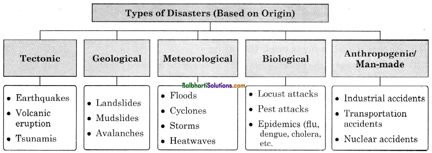
Types of Disasters (Based on Origin)

Tectonic:

  • Earthquakes
  • Volcanic
  • eruption
  • Tsunamis

Geological:

  • Landslides
  • Mudslides
  • Avalanches

Meteorological:

  • Floods
  • Cyclones
  • Storms
  • Heatwaves

Biological:

  • Locust attacks
  • Pest attacks
  • Epidemics (flu, dengue, cholera, etc.

Arthropogenic/Man-made

  • Industrial accidents
  • Transportation accidents
  • Nuclear accidents

Maharashtra Board Class 11 Geography Notes Chapter 9 Disaster Management 1

→ Natural events that occur in nature and cannot be prevented are called hazards. When they occur in areas inhabited by humans and cause damage, they are termed as disasters.

Hazards :

  • Hazards are phenomena that pose a threat to people, structural or economic assets and which may cause a disaster.
  • They could be either naturally occurring in the environment or man-made.
  • A hazard becomes a disaster when it affects human population, settlements and their activities.

Vulnerability :

  • The geographical conditions and circumstances of people or region that make them susceptible to a disaster is known as vulnerability. Hence, if we are better prepared, we can reduce the risk of getting affected by disaster.
  • Population living in certain areas are exposed to particular disasters.
DisasterPeople/Areas affected
1. CyclonePeople living in coastal areas are more likely to be affected than those in the interior.
2. EarthquakesPeople living in seismically active areas are prone to earthquakes.

Also, social, economic and political conditions may make people less or more likely to be affected by disasters, in the same region.

Example :

  • The poor are more likely to be affected by disasters.
  • Old people and children easily become victims of disasters.
  • Densely populated areas more likely to be affected than sparsely populated areas.

Capacity to Cope :

  • The ability of people, organisations and systems, using available skills and resources, to face and
    manage disasters is known as their capacity to cope. ,
  • Vulnerability is reduced if capacity to cope with the disaster is high.

Effects of Disasters:

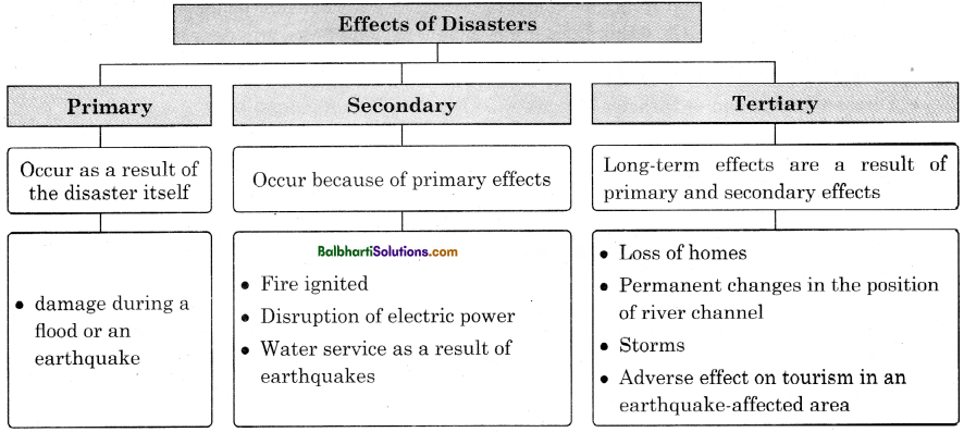
Effects of Disasters –

  1. Primary
  2. Secondary
  3. Tertiary

1. Primary

  • Occur as a result of the disaster itself

damage during a flood or an earthquake

2. Secondary:
Occur because of primary effects

  • Fire ignited
  • Disruption of electric power
  • Water service as a result of earthquake

3. Tertiary
Long term effects are a result of primary and secondary effects

  • Loss of homes
  • Permanent changes in the position of river channel
  • Storms
  • Adverse effect on tourism in an earthquake-affected area

Maharashtra Board Class 11 Geography Notes Chapter 9 Disaster Management 2

Disaster Management:
Disaster Management Disasters:

1. Preventable

  • Gas leakage
  • Rail accident

2. Non-preventable

  • Volcanic eruptions
  • Tsunamis
  • Earthquakes (effect can be reduced)

3. Predictable

  • Cyclones
  • Floods

Maharashtra Board Class 11 Geography Notes Chapter 9 Disaster Management 3

Disaster Management involves the following processes –

  • Creating awareness about disasters.
  • Taking steps to reduce its effects
  • Evaluating the damage caused by the disasters providing relief, food and medical aid in affected areas involve many people, organisations and processes.

Disaster Management Tasks:

Maharashtra Board Class 11 Geography Notes Chapter 9 Disaster Management 4

Disaster management tries to :

  • Reduce risk to damages or losses.
  • Focus on the hazard that causes the disaster.
  • Attempt to minimize the adverse impact of the disaster on communities.
  • Involve co-ordination from governments, local self-governments, police, military and para¬military forces, NGOs, doctors, scientists, planners, volunteers, groups or communities.

Disaster Management Cycle :

  • Disaster Prevention → Disaster Mitigation → Disaster Preparedness.
  • Pre-disaster planning is the process of preparing in advance to face disasters in future.

Disaster Preparedness :
It involves measures taken to prepare for and reduce effect of disasters.

Disasters Preparedness:

  1. Carrying out awareness campaigns
  2. Strengthening of the weak structures
  3. Preparing plans for households
  4. Preparing plans at community level

Maharashtra Board Class 11 Geography Notes Chapter 9 Disaster Management 5

Mitigation :

  • Mitigation is any measure taken to minimize the impact of a disaster before it occurs is known.
  • It refers to action taken against potential disasters.
  • It is carried out for those disasters which cannot be prevented.
  • It helps the people by creating safer communities and reducing loss of life and property.

Mitigation Measures:

  1. Community level disaster planning
  2. Public awareness and information campaigns
  3. Preparedness of hospitals
  4. Construction of houses away from hazardous areas.

Maharashtra Board Class 11 Geography Notes Chapter 9 Disaster Management 6

Mitigation Efforsts:

Structural Efforts:

  • Construction of river embankments
  • Strengthening existing buildings

Non-structural Efforts:

  • Areas training in disaster management
  • Regulating land-use
  • Public education

Maharashtra Board Class 11 Geography Notes Chapter 9 Disaster Management 7

Disaster Response :

  • It is the way the community responds to the disaster.
  • It reflects the preparedness of the community.
  • It is the immediate period after the disaster strikes.
  • It is concerned with providing food and shelter to the disaster victims, restoring normal condition and providing financial support.

Recovery :
These steps involve measures taken to bring life back to normal in affected areas.

Recovery:

  • Restoration of basics services and repair of physical, social and economic damages
  • Cleaning of debris
  • Rebuilding roads and bridges
  • Providing sustained medical care for displaced human and animal population

Maharashtra Board Class 11 Geography Notes Chapter 9 Disaster Management 8

Rehabilitation :

  • It is the last phase of disaster management.
  • It involves :
    • Efforts taken to restore normalcy in the long term.
    • Providing housing to the affected, taking important decisions regarding economy, agriculture, etc., which have been affected by disasters.

Role of Remote Sensing, GIS and GPS in Disaster Management:

Remote Sensing :

  • Remote sensing is very effective in mapping disaster prone areas, particularly flood – affected areas.
  • Microwave data – Provides information on flood-inundated areas.
  • Remote sensing satellites monitor the path of a cyclone.
  • It can provide ample time with warning for evacuation and preparedness in advance.
  • Data obtained from meteorological satellites is used for cyclone tracking, intensity and landfall predictions and forecasting of extreme weather events.
  • Data from earth observation satellites is used for monitoring disaster events and assessing
    the damages. ,
  • Communication satellites help to establish communication in remote and inaccessible areas.
    Navigation satellites are used for providing location-based services.

GPS (Global Positioning System): It is an important tool.

GIS:

  • It has emerged as an important methodological tool for effective planning, communication and training in the various stages of the disaster management cycle.
  • Plays a vital role in determining the extent of hazards and disasters.
  • These techniques help in making planning and policy very easy for implementation.

Disaster Management in India :
Need : India’s geo-climatic conditions and its high degree of socio-economic vulnerability makes it one of the most disaster-prone country in the world.

Steps taken to mitigate the damage potential of national disasters in future at the Government of India level, two institutes were set up in New Delhi.

  • The National Institute of Disaster Management (NIDM)
  • The National Disaster Management Authority (NDMA) has been established at the centre.
  • SDMA has been established at the state level.
  • District Authorities at District level.
  • National Crisis Management Committee also functions at the centre.
  • Ministry for Agriculture – For disasters like drought.
  • Military forces, para-military forces such as Home Guard.
  • ISRO, NRSC (National Remote Sensing Centre) also play an important role in disaster management.

Maharashtra Board Class 11 Political Science Notes Chapter 1 The State

By going through these Maharashtra State Board Class 11 Political Science Notes Chapter 1 The State students can recall all the concepts quickly.

Maharashtra State Board Class 11 Political Science Notes Chapter 1 The State

Introduction:
In this chapter, we shall cover the following political concepts –
(i) Nation and Nationalism (ii) State and Government.
The terms ‘state’, ‘nation’, ‘government’ appear to have the same meaning and are often used interchangeably. However, technically there is a difference in the meaning of these terms.

A Nation has a sense of ‘oneness’ that is psychological and is born out of commonness of ethnicity and race, culture and history, religion, language, etc. A State is a politically organized society within a definite territory. It is used to describe a sovereign country having an independent government in specific territory.

Nation:
Meaning: The word ‘nation’ is derived from the Latin word ‘Nasci’ meaning ‘to be born’. Thus, the literal meaning of a nation is a people having a common race /ethnicity or cultural linkages.

Ernest Barker defines a nation as a body of men, inhabiting a definite territory, who normally are drawn from different races but possess a common stock of thoughts and feelings acquired and transmitted during the course of common history.

A nation refers to a large group of people, united in common bonds of geography, race, history, religion, language, sharing common objectives.

Maharashtra Board Class 11 Political Science Notes Chapter 1 The State

Features Of A Nation:

  • Population: A nation must have a population that has a sense of ethnic, historical and cultural oneness.
  • Feeling of community: The emotional dimension of a nation is a perception held by the population of psychological oneness i.e., they are a community.
  • Desire to be politically separate: A feeling of unity and of being a nation is a product of the urge for ‘self-determination’. This can lead to a demand for self-governance. This signifies that people who feel united should have the right to decide the type of government that they prefer.

Nationalism:
Meaning: Nationalism is a force which binds the people to a sense of integrity and loyalty to their country. It is a spirit of oneness or common consciousness that binds a community together. Nationalism is a sense of political identity and emotional attachment to one’s ’homeland’.

Features Of Nationalism:

  • Nationalism can be productive i.e., Progressive nationalism e.g., India’s freedom struggle or destructive i.e., Aggressive nationalism e.g., in Nazi Germany.
  • Nationalism opposes imperialism and colonialism and thus encourages self-determination. Liberation /Freedom struggles all over the world are in resistance to foreign rule or any tyranny.
  • Nationalism can help to promote diversity. The core of Indian nationalism is the idea of ‘unity in diversity in respect of religion, region, caste, language, etc.

Forms Of Nationalism:
The forms of nationalism from a political perspective are:

  • Liberal Nationalism: Its origins are in the ideals of the French Revolution. President Woodrow Wilson linked the concept of a nation to the right to self-determination and sovereignty.
  • Conservative Nationalism: It views a nation as a closely linked society with great importance to patriotism and the concept of ‘motherland’.
  • Expansionist Nationalism: It is aggressive nationalism, which leads to imperialism, conquest and colonialism. It was seen in European imperialism by countries like England, Italy, Spain, France, etc.
  • Anticolonial Nationalism: It refers to liberation struggles for independence from colonial rule, e.g., Indian or Indonesian freedom struggles from British and Dutch colonialism respectively.

The State:
The urge for political self-determination leads a nation toward statehood. A State is a political community which plays a role in almost every human activity like education, law and order, social welfare, etc.

Meaning of a State: Woodrow Wilson (USA) defined ‘a state is a people organised for law within a definite territory. A state is a community of persons, more or less numerous, permanently occupying a definite portion of territory, independent from external control and possessing an organized government to which the inhabitants render habitual obedience.

Maharashtra Board Class 11 Political Science Notes Chapter 1 The State

Elements of a State: The modern State has four essential elements.

Population: A State is an association of human beings. The progress of a state depends on the quality of population. Some states viz. China, India, etc. have a large population while some states have a small population viz. Monaco, Belgium, etc., The population may be homogeneous or diverse for e.g., USSR comprised of many nationalities like Russians, Ukrainians, Latvians, etc. Thus a ‘State’ may comprise of many ‘nations’.

Territory: A State is recognized by its territory. This includes the land area within its boundaries, airspace above the area and surrounding territorial waters (up to 12 nautical miles). The area within which the State has the authority to govern is called its jurisdiction.

Some States have small territory e.g., Sri Lanka, Bhutan, Maldives, etc., while other States e.g., Brazil, Russia, India, Australia have a large territory. Most States have compact territory e.g., India, while some states have a scattered territory e.g., Great Britain.

Government: This refers to the agency through which the will of the State is expressed. Modern governments have three organs viz. legislature, executive and judiciary. The Government must be independent. Institutions of the state are ‘public’ institutions and have legitimacy to act on behalf of the State.

These institutions are responsible for making and implementing laws to promote the general welfare of the people. There are various kinds of government based on their creation or style of functioning for e.g., democracy/ dictatorship, republic/monarchy, presidential/parliamentary, etc.

Sovereignty: It signifies the supreme power of the State internally as well as externally. It means an independent nation with its own constitution.

State And Government:
The government is an essential element of the State which is composed of a limited number of elected or nominated persons. It derives its power from the State. Its nature is administrative. A State cannot function in the absence of a government.

Maharashtra Board Class 11 Economics Notes Chapter 5 Rural Development in India

By going through these Maharashtra State Board Class 11 Economics Notes Chapter 5 Rural Development in India students can recall all the concepts quickly.

Maharashtra State Board Class 11 Economics Notes Chapter 5 Rural Development in India

Meaning Of Rural Development:

  • Leads to economic growth of a country.
  • It is a ‘subset’ of term “development”.
  • Relates to overall development and improvement in quality of life
  • It should be sustainable, in order to remove poverty from any country.

Maharashtra Board Class 11 Economics Notes Chapter 5 Rural Development in India 1

Maharashtra Board Class 11 Economics Notes Chapter 5 Rural Development in India

Definition of Rural Development:

World Bank defines :
“Rural development is a strategy designed to improve the economic and social life of a specific group of people – the rural poor. Rural development involves extending the benefits of development to the poorest among those, who seek livelihood in the rural areas. The group includes small scale farmers, tenants and the landless’’.

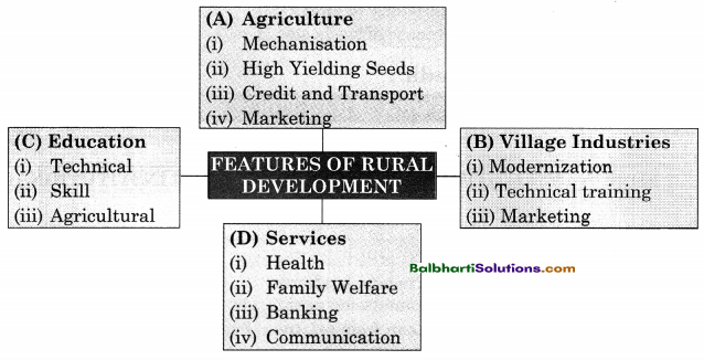
Features of Rural Development:

(A) Agriculture:

  • Mecha nisation
  • High Yielding Seeds
  • Credit and Transport
  • Marketing

(B) Village Industries:

  • Modernization
  • Technica’ training
  • Marketing

(C) Education

  • Technical
  • Skill
  • Agricultural

(D) Services

  • Health
  • Family Welfare
  • Banking
  • Communication

Maharashtra Board Class 11 Economics Notes Chapter 5 Rural Development in India 2

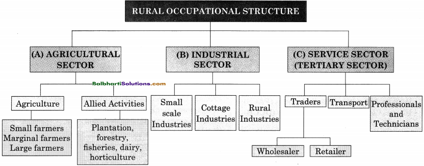
Rural Occupational Structure:

(A) Agricultural Sector
(B) Indrustrial Sector
(C) Services Sector (Tertiary Sector)

(A) Agricultural Sector

  1. Agriculture
  2. Allied Activities

1. Agriculture

  • Small farmers
  • Marginal farmers
  • Large farmers

Allied Activities:
Plantation, forestry, fisheries, dairy, horticulture

(B) Indrustrial Sector:

  • Small scale Industries
  • Cottage Industries
  • Rural Industries

(C) Services Sector (Tertiary Sector):

  1. Traders
  2. Transport
  3. Proffessional and Technicians

Traders:

  • Wholesaler
  • Retailer

Maharashtra Board Class 11 Economics Notes Chapter 5 Rural Development in India 3

Maharashtra Board Class 11 Economics Notes Chapter 5 Rural Development in India

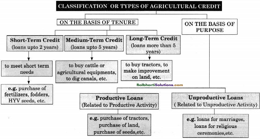
Classification or Types of Agricultural Credit:

Maharashtra Board Class 11 Economics Notes Chapter 5 Rural Development in India 4

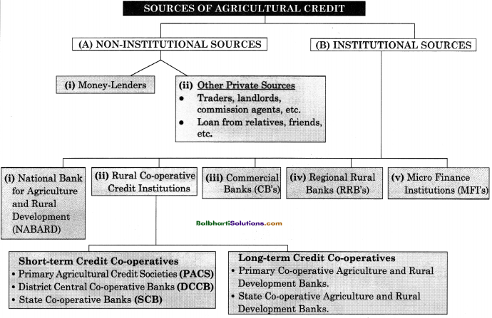
Sources of Agricultural Credit:

(A) Non-Institutional Sources
(B) Institutional Sources

(A) NON-INSTITUTIONAL Sources

  1. Money-Lenders
  2. Other Private Sources
    • Other Private Sources:
    • Traders, landlords, commission agents, etc.
    • Loan from relatives, friends, etc.

(B) Institutional Sources:

  1. National Bank for Agriculture and Rural Development (NABARD)
  2. Rural Co-operative Credit Institutions
  3. Commercial Banks (CB’s)
  4. Regional Rural Banks (RRB’s)
  5. Micro Finance Institutions (MFI’s)

Rural Co-operative Credit Institutions

  • Short-term Credit Co-operatives
  • Long-term Credit Co-operatives

Short-term Credit Co-operatives:

  • Primary Agricultural Credit Societies (PACS)
  • District Central Co-operative Banks (ÐCCB)
  • State Co-operative Banks (SCB)

Long-term Credit Co-operatives:

  • Primary Co-operative Agriculture and Rural Development Banks.
  • State Co-operative Agriculture and Rural Development Banks.

Maharashtra Board Class 11 Economics Notes Chapter 5 Rural Development in India 5

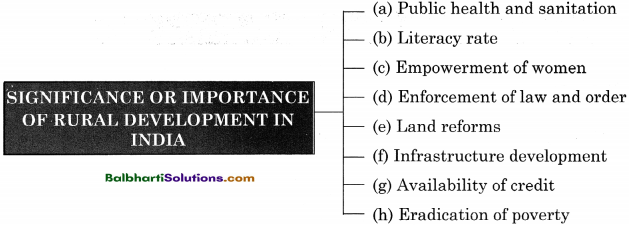
Significance or Importance of Rural Development in India :

  • Public health and sanitation
  • Literacy rate
  • Empowerment of women
  • Enforcement of law and order
  • Land reforms
  • Infrastructure development
  • Availability of credit
  • Eradication of poverty

Maharashtra Board Class 11 Economics Notes Chapter 5 Rural Development in India 6

Maharashtra Board Class 11 Economics Notes Chapter 5 Rural Development in India

Word Meaning:

predominantly – mainly, rural – village area, subset – part of a larger group, connotes – suggest, consensus – general opinion, alleviate – to reduce, strategy – planning, tenants – a person who occupies land or property on rental basis, marginal – very small, cottage – industry carried out in people’s home, witnessed – to see, affordable – reasonable price, instrument – a tool, gender disparity – not having equal rights for male and female, safeguard – protect, enforcement – carrying out, ceiling – limitation, connectivity – to link, eradication – to remove, pre-requisite – requirement, inadequate – not sufficient, tenure – time period, unproductive – not able to use in productive activity, collateral security – asset kept against loan, prevalent – spread, mortgage – to keep asset against the loan, promotion – to support, consequent – as follows, inflexibility – not able to change, legitimate – allowed by law.

Maharashtra Board Class 11 History Notes Chapter 4 Vedic Period

By going through these Maharashtra State Board Class 11 History Notes Chapter 4 Vedic Period students can recall all the concepts quickly.

Maharashtra State Board Class 11 History Notes Chapter 4 Vedic Period

Vedic Culture:
Vedic literature, Linguistics and Archaeology:
Most of the information about their culture is derived from the Vedic literature. This literature is fundamentally in the form of the faith systems of the Vedic tribes and eulogies of their deities. There are various opinions about the chronology of the Vedic culture. However, there is a general agreement that the Vedic people composed Rigveda in India around 1500 B.C.E. However, Lokmanya Tilak calculated this date as 6000 B.C.E. on the basis of astronomical events.

This debate began in the 16th century. Till then the concept of the ‘Aryans’ was not known. In the 16th century, the European academics became aware of the similarities between Sanskrit and Latin- Greek languages. It resulted into the notion of the ‘Indo-European’ language family.

Vedic Literature and Social organisation of Vedic Times:
The Vedic literature is supposed to be the earliest literature of India. They were written in Sanskrit. The four Vedas form the core of the Vedic literature.

Rigveda: The Rigveda contains Suktas (hymns) composed to eulogise the deities. The verses in Rigveda are known as ‘Rucha’. A number of Ruchas strung together makes a Sukta (hymn). Many Suktas make one Mandala.

Yajurveda: The Yajurveda offers explanation of the sacrificial rituals. It explains when and how the mantras should be used. A Rigvedic richa, when recited in sacrificial rituals, is regarded as Mantra. The Yajurveda is a combined composition of the Rigvedic richa in verse and the explanation of its use v as a mantra in prose.

Samaveda: The Samaveda is a text that gives the rules of reciting mantras in a musical form. The Samaveda is regarded as the text that is fundamental in the development of Indian music.

Maharashtra Board Class 11 History Notes Chapter 4 Vedic Period

Atharvaveda: The Atharvaveda is about the day-to-day life. It contains information about charms and medicines for various problems and diseases. It also talks about the norms of statesmanship.

Varna System:
The Vedic society was organized into four classes known as ‘Varna’, namely, Brahmana, Kshatriya, Vaishya and Shudra. The varna system is first mentioned in the tenth mandala (chapter) of the Rigveda. In the later Vedic period, the varna system lost its flexibility. Also, the caste system got rooted firmly by this period.

In the beginning, the varna or the caste was decided by one’s occupation. Later it came to be determined on the basis of birth. Hence it became impossible to change one’s varna and caste, in which he/she was born.

Maharashtra Board Class 11 History Notes Chapter 4 Vedic Period

Ashrama System:
The Ashrama System of the Vedic culture lays down the norms of living an ideal life by dividing the span of human life into four successive stages, namely Brahmacharyashram, Grihasthashram, Vanaprasthashram and Sanyasashram.

  • In the first stage one was expected to spend an austere life and earn knowledge and necessary occupational skills.
  • In the second stage one was expected to fulfil one’s prescribed duties with one’s wife by his side.
  • In the third stage one was expected to retire from the active life of the householder and if the need be, to give advice to the younger people. It was also desirable that one should stay away from human settlement.
  • In the fourth and the last stage one was expected to renounce all the family bonds, accept a wandering life and to go away. A Sanyasi was not permitted to settle at one place for a longer time.

The Early Vedic Culture as unfolded through Vedic Literature:
The Rigvedic culture is the culture of the Early Vedic period. The tribes of the Early Vedic period staying in the Saptasindhu region have been mentioned in the Rigveda. Among them occur the names like Puru, Anu, Yadu, Druhyu, Turvash, etc. They were the tribes who subsisted on agriculture.

The Rigveda mentions a battle known as ‘Dashradnya Yuddha’ that was fought among ten tribal chiefs. In the Early Vedic period along with the Rigvedic tribes, other local tribes also stayed in the Saptasindhu region, who did not belong to the Rigvedic people. They were called ‘Das’, ‘Dasyu’ and ‘Pani’. Panis were looked upon as enemies by the Vedic people. Panis used to steal the cattle of the Vedic people.

Later Vedic Period:
Later Vedic Period is dated to around 1000-600 B.C.E. The information about this period is gathered from the treatises written in that period. The material culture as reflected in the epics, Ramayana and Mahabharata was studied with the help of archaeological evidence.

A picture of the migration in the Later Vedic period can be gathered from the Saptasindhu region toward the east and its geographic markers from the literature of that period. The Later Vedic period saw a gradual formation of confederacies of the Vedic villages. They were known as ‘Janapada’. Generally, the seniors and the elites in a Janapada collectively took social decisions.

Maharashtra Board Class 11 History Notes Chapter 4 Vedic Period

Glossary:

→ Philology – A discipline that traces the etymological history and meanings of words.

→ Etymology – The study of the origin of words and the way in which their meanings have changed throughout history.

→ Dasyu – It is derived from the Sanskrit word “Dasa”. Usually means enemy or servant.

→ Suktas – Hymns.

→ Eulogise – Praise highly in speech or writing.

→ Oligarchy – A small group of people having control of a country or organization.

Maharashtra Board Class 11 Geography Notes Chapter 8 Biomes

By going through these Maharashtra State Board Class 11 Geography Notes Chapter 8 Biomes students can recall all the concepts quickly.

Maharashtra State Board Class 11 Geography Notes Chapter 8 Biomes

→ Natural vegetation and wildlife change according to latitudes. Hence, a variety of natural vegetation is found in different regions from the equator to the poles.

→ Biome : An area where different types of flora and fauna live together in the same region in the same type of climatic conditions is called a biome.

→ It is the total assemblage of plant and animal species interacting within specific conditions.

Elements of climate that affect the boundaries of biomes:

  1. Rainfall
  2. Temperature
  3. Humidity
  4. Amount of insolation received
  5. Soil conditions

Maharashtra Board Class 11 Geography Notes Chapter 8 Biomes 1

Biome:
The combined co-existence of flora and fauna which is a result of the region’s climate.
Ecosystem:
The interaction between biotic and abiotic factors.

Maharashtra Board Class 11 Geography Notes Chapter 8 Biomes

Biotic Factors:
They consist of plants, various types of animals, bacteria, etc.
Abiotic Factors:
They consist of soil, water, sunlight and nutrients.

→ Through the abiotic factors, the biotic components receive supply of nutrients and energy.

Tropical Rainforest Biome :

  • Latitudinal Extent : 0° to 10° N and S.
  • Vegetation : Biodiversity is very high.
    Categorized into three layers – lowermost layer – bushes; middle layer low trees: third layer – tall, huge trees.
  • Animal Life : Three-tier system of trees allows every bird and animal to have its own niche in the areas from the ground to the tree top.
  • Human Life : Indigenous tribes live primitive lives.
    Practice primary occupations – like food-gathering and hunting.
  • Use of Biome by Man : Hardwood is used in construction and making furniture.
    For this, some regions are being over exploited.
  • Current Scenario: Degradation is increasing because of increasing agriculture and industrialisation. Rare species of animals and birds are threatened.

Tropical Deciduous Biome :

Latitudinal Extent: 5° to 30° N and S.

Vegetation: Deciduous Forests – trees drop leaves in dry season; they are dense and lush in rainy season.

Animal Life: A large diversity in fauna. Biodiversity found in these biomes ranks second in the world.

Human Life : Easier than that in the rainforest.
People practicing primary and secondary occupations based on forest are found here.
Various tribal communities inhabit these regions.
There are rural and urban areas, too.
These forests are being encroached upon.

Use of Biome :

  • Wood from teak has many uses.
  • Plants are used for medicines and secondary products.
  • Bamboos are used for construction of houses and agriculture.
  • Various fruits and spices are also obtained.

Current Status :

  • Forests are in danger due to deforestation and wildfire.
  • Wild species are endangered by humans through extensive use of fertilizers and spray of insecticides.
  • This biome is influenced by human population.

Maharashtra Board Class 11 Geography Notes Chapter 8 Biomes

Savannah Grassland Biome:

  • Latitudinal Extent : 10° to 20° N and S.
  • Vegetation : Grasslands with perennial cover of grass that grows 3 m to 6 m in height. Elephant Grass – thick, coarse, broad-leaved.
    Very few shrubs and trees found.
  • Animal Life : The abundance of grass cover and its perennial nature makes savannah biomes rich in herbivore animals.
  • Human Life Grass provides shelter to animals. Biome also supports carnivore animals. Comparatively difficult human life.
  • Use of Biome In the past this biome was used to hunt for trophies and hence was known as a heaven for hunting.
  • Current Status Victim of frequent forest fires; loss of biodiversity.
    Due to overgrazing, industrialisation and agriculture the area under grassland is decreasing, leading to extension of the Sahara Desert in Africa.

Tropical Desert Biome :

  • Latitudinal Extent : 20° to 30° N and S
  • Vegetation: Dispersed due to dry climatic conditions.
    Typical desert vegetation.
  • Animal Life: Limited biodiversity. Few large animals in desert.
    Small animals – burrowing type.
    Birds and insects are also found.
  • Human Life Human life is very difficult.
    Depending on the availability of water, animal husbandry or agriculture is followed.
    Human settlements found only near oasis, in a dispersed manner.
  • UseofBiome : Dates are produced as food item.
    Agriculture with the help of irrigation. Mining is also an activity.
  • Current Status : Desertification is increasing. ,

Mediterranean Biome :

  • Latitudinal Extent: 30° to 40° N and S.
  • Vegetation: Shorter trees.
    Mixed vegetation: evergreen and deciduous.
    Trees of citrus family, shrubs of coloured flowers.
  • Animal Life: Herbivores, birds of prey, reptiles and various types of insects and honeybees.
  • Human Life: Pleasant climate.
    Human life has flourished very well. Industries based on fruits and flowers. Tourism and development of cinema industry.
  • Current Status: Tertiary occupations and urbanisation has increased.
    Biodiversity found in plants and animals is decreasing due to human interference.

Temperate Deciduous Biome :

  • Latitudinal Extent: 40° to 50° N and S.
  • Vegetation: Broad-leaved trees.
    3 levels of trees : tall trees, short trees, and shrubs.
    Hardwood and deciduous trees.
  • Animal Life: Animals have thick and soft fur.
    Birds and insects are found.
  • Human Life: Forests provide food, wood and ample amount of oxygen.
    Forests being encroached upon for agriculture.
  • Current Status: Biome reducing due to agriculture and encroachment by settlements. Biodiversity has reduced.
    Habitat of animals is being encroached upon.

Maharashtra Board Class 11 Geography Notes Chapter 8 Biomes

Temperate Grasslands Biome:

  • Latitudinal Extent: 40° to 55° N and S.
  • Vegetation: Soft grass is dominant.
    Not many types of trees.
  • Animal Life: Rich and varied animal life.
    Herbivore animals are found.
  • Human Life: Human settlements are sparse.
    Earlier, hunting was the main occupation. Presently, agriculture and animal rearing.
  • Current Status : Commercial agriculture is increasing.
    Industries are increasing.
    Meadows and pastures are reducing because of over grazing.
    Biome is getting degraded.

Taiga Biome :

Latitudinal Extent : 50° to 55° N.

Vegetation :One type of tree species.
Evergreen coniferous forests.
Tall trees, tapering to the apex.
Waxy leaves and branches tapering to the ground do not let snow stay on the trees.

Animal Life: Animals have thick hides to survive the snow-covered ground.

Human Life: Climate is very cold, so human settlement is sparse.
Occupation is lumbering.
Saw mills, paper pulp, wooden furniture industries.

Current Status: Deforestation is easy because the wood is soft.

Tundra Biome:

Latitudinal Extent: 65° to 90° N.

Vegetation: It is the coldest biome.
Ground is frozen for 8 months of the year.
There is a layer of permanently frozen ground below the surface, called permafrost.
Vegetation has adapted to the cold and short growing season.

Animal Life: Very scarce animal life.
Animals have thick fur, layers of fats in their bodies to face the cold climate.

Human Life: Very sparse human settlements.
Recently life has changed and fishing methods have improved. Exploitation of fish is faster.

Current Status: Biome is experiencing more development due to increased transportation and means of communication.
Standard of life has improved.
Global warming is badly affecting the snow cover and the dependent species.

Maharashtra Board Class 11 Geography Notes Chapter 8 Biomes

Mountain or High Biome :

Latitudinal Extent: Not specific.
It depends on altitude, slopes of high mountain ranges like the Himalayas, the Andes, and the Rockies.

Vegetation: Ranges from deciduous to tundra according to altitude.
Plants are small and perennial.

Animal Life: Animals with special adaptation to snow.

Human Life: In some areas, people grow crops.
Grazing and sheep rearing are primary occupations.
Tourism has developed in such biomes.
Transhumance is practiced.

Current Status: Over tourism has caused overcrowding.
Mountain biomes are threatened by deforestation, wildfires, hunting, poaching and urban sprawl.

Aquatic Biomes :
Besides the terrestrial biomes of the world, we find biomes in the water too. For example, oceans, rivers, lakes, etc.

Maharashtra Board Class 11 Geography Notes Chapter 8 Biomes

Aquatic Biomes :

  1. Freshwater Biomes
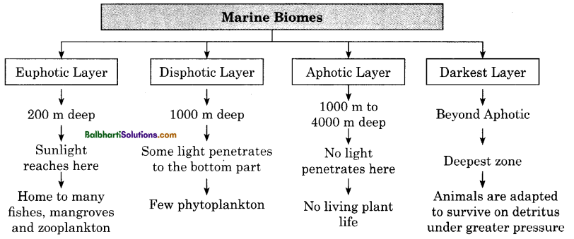
  2. Marine Biomes
  3. Wetland Biomes
  4. Coral Reef Biomes
  5. Estuaries

Maharashtra Board Class 11 Geography Notes Chapter 8 Biomes 2

Maharashtra Board Class 11 Geography Notes Chapter 8 Biomes 3

Maharashtra Board Class 11 History Notes Chapter 2 First Cities of India

By going through these Maharashtra State Board Class 11 History Notes Chapter 2 First Cities of India students can recall all the concepts quickly.

Maharashtra State Board Class 11 History Notes Chapter 2 First Cities of India

Characteristics of Harrapan Civilisation:
A few years ago, it was strongly believed that the Vedic Aryans arrived in India at about 1500 B.C.E. However, no information was available regarding the period before that. This situation continued till the discovery of Harappa in 1921 and Mohenjodaro in 1922.

The discovery of the Harappan Civilisation at these two places stretched the antiquity of Indian history to 3500-3000 B.C.E. Harappan civilisation belonged to ‘Bronze Age’. So far, more than 2000 sites of the Harappan civilisation have been recorded. The history of these cities had three stages viz:

  • Early Harappan period
  • Mature Harappan (Urban) period
  • Late Harappan period
  • Some of the main characteristics of the Harappan cities are
  • Systematic Town Planning
  • Central Administration
  • Social Organisation
  • Economy
  • Use of Developed Writing System
  • Some cities of Harrapan Civilisation:

Harappa: Harappa is situated on the banks of the river Ravi (District Sahiwal in Punjab, Pakistan). The v ancient site of Harappa had spread on 150 Hectares. The first excavation at Harappa began in 1921. The first settlement of the Early Harappan period was established around 3300 B.C.E. It evolved to the Mature Harappan (urban) phase around 2600 B.C.E. It reached its peak during 2450-1900 B.C.E.

Maharashtra Board Class 11 History Notes Chapter 2 First Cities of India

Mohenjodaro: Mohenjodaro was built on the banks of the river Sindhu (Indus) in Pakistan (District Larkana, Sindh). Area wise, Mohenjodaro is the biggest city, among those discovered in Pakistan so far. It was thought that the city was divided into two fortified sections, namely the ‘Citadel’ and the ‘Lower Town’.

The excavations at Mohenjodaro by Rakhaldas Banerjee began in 1921-22. In 1923- 24 to gather more information about Mohenjodaro Madho Sarup Vats, Kashinath Narayan Dikshit, Earnest Mackay and others conducted further excavations under Sir John Marshall’s direction. He was the Director-General of the Archaeological Survey of India at that time. During these excavations, various artefacts, houses and public monuments were unearthed.

Kalibangan: The site of Kalibangan is 205 kilometres away from Bikaner. It is located in the Hanumangarh district of Rajasthan. It was one of the important urban centres of the Harappan civilisation, situated on the banks of the river Ghaggar. L. P. Tessitore, an Italian linguist had visited Kalibangan during his study tour of the region.

It was conducted under the direction of Brijabasi Lai, the then Director-General of the Archaeological Survey of India and Balkrishna Thapar. At Kalibangan two settlements, one of the Mature Harappan period and the other of the Early Harappan period, were found. Kalibangan was a small city compared to Harappa and Mohenjodaro.

Lothal: Lothal was established on the banks of the river Bhogao. The centre of the Harappan civilisation at Lothal was situated near the Gulf of Kutch, in Gujarat, 80 kilometres away from Ahmedabad. It is known for the remains of Harappan dock. Lothal was excavated from 1955 to 1960 under the supervision of S.R. Rao. The ‘Citadel’ and the ‘Lower Town’ at Lothal do not have separate fortification walls. Rather they are surrounded by a single fortification wall.

Dholavira: Dholavira was discovered by J.P. Joshi, the Director-General of Archaeological Survey of India. The site is in ‘Khadirbet’ in Gujarat (Dist. Kutch). Excavations at the site were started by R.S. Bisht in 1990. Among the excavated Harappan sites, extent wise Dholavira is the fifth-largest city. An Early Harappan settlement was discovered at Dholavira. There was a protective wall built around it by using mud bricks (unbaked bricks) and dressed stones. It was surrounded by an outer fortification wall.

The settlement within the outer fortification was divided into four sections.

  1. Citadel
  2. The adjacent section reserved for high officials
  3. Lower Town – These three sections had walls, which separated them from each other.
  4. The fourth section inside the outer fortification did not have any additional separating walls.

Maharashtra Board Class 11 History Notes Chapter 2 First Cities of India

Rakhigarhi: In the Hissar district of Haryana is situated the site of Rakhigarhi, a Harappan city. It is on the distance of 150 kilometres from Delhi. It is located on the banks of Chautang (ancient Drishdvati river). Rakhigarhi is the largest Harappan site, among all the sites from India and Pakistan.

Its total area was more than 350 Hectares. The excavations at Rakhigarhi started in 1963. It continued in 1997-2000. Later, Dr Vasant Shinde of the Deccan College, Pune also conducted excavations at the site.

Inter-relationship between Cities and Villages:
The city people are dependent on the natural resources and villages in their vicinity in order, to meet the needs of urban way of life and urban administration. The raw material needed for Harappan industrial production included clay, various siliceous and semi-precious stones, metals, etc.

The inter-relationship between Harappan cities and villages was dependent on the mechanism of making available, things like food grains and the raw materials.

Production, Trade, Organisation and Administration:
During the Mature (urban) Harappan period the sphere of commodity exchange expanded and their import-export increased to a great extent. The internal and distant trade received momentum. Trade with distant places like Mesopotamia became regular. Trade with Mesopotamia had begun during Early Harappan times.

The Akkadian empire was founded in 2334 B.C.E. by Emperor Sargon I. During his reign the Harappan trade with Mesopotamia flourished and the Harappan cities reached their peak. Harappan period and the sea trade had become the preferred mode. ‘Dilmun’, ‘Makan’ and ‘Meluhha’ are mentioned as three important centres on the sea route. Harappan traders are likely to have received wool, gold and silver in exchange other commodities.

Maharashtra Board Class 11 History Notes Chapter 2 First Cities of India

Decline of the Cities:
When Harappan civilisation was discovered, it was presumed that its cities were destroyed by invading tribes who came from outside. Indra is described as ‘Purandara’ meaning the destroyer of fortified cities. The Harappan cities were fortified, thus befitting the definition of ‘pura’. Deteriorating environment was the main reason of the decline of Mesopotamia. Similarly, climatic changes and deteriorating environment were the main reasons of the decline of the Harappan civilisation too. Around 2000 B.C.E. the climate became increasingly arid and there were frequent famines. Degradation of cultivable land was on the increase.

Glossary:

→ Fortification – Walls, towers etc. built especially in the past to protect a plact’ against attack.

→ Artefacts – An object that is made by a person.

→ Citadel – A castle on high ground or near a city where people could go when the rity is attacked.

→ Granary – A large building for storing grains.

→ Linguist Someone who studies the structure and development of language.

→ Furrow – A trench in the earth made by a plough.

→ Dock – An area of a port where ships stop to be loaded, repaired etc.

→ Dwindled – To become smaller or weaker.

Maharashtra Board Class 11 Geography Notes Chapter 7 Indian Ocean – Relief and Strategic Importance

By going through these Maharashtra State Board Class 11 Geography Notes Chapter 7 Indian Ocean – Relief and Strategic Importance students can recall all the concepts quickly.

Maharashtra State Board Class 11 Geography Notes Chapter 7 Indian Ocean – Relief and Strategic Importance

Maharashtra Board Class 11 Geography Notes Chapter 7 Indian Ocean – Relief and Strategic Importance

Indian Ocean – Introduction :

  • The Indian Ocean is the third largest ocean in the world. Its average depth is 4000m,
  • It is the only ocean in the world named after a particular country, i.e., India.
  • It occupies about 20 percent of the total oceanic area.
  • The Indian Ocean spreads between Africa in the west, Asia in the north and east, Australia in the east and Southern Ocean in the south.
  • It is blocked northwards, resulting in development of monsoon climate of the Indian sub-continent.

Bottom Relief of the Indian Ocean :

  1. Continental Shelf
  2. Mid-Oceanic Ridges
  3. Ocean Basins
  4. Oceanic Deeps
  5. Islands

Maharashtra Board Class 11 Geography Notes Chapter 7 Indian Ocean – Relief and Strategic Importance 1

Continental Shelf:

  • Continental Shelf is a portion of continents, submerged under oceanic water.
  • It is normally occupied by gulfs, seas, bays, straits.
  • A continental shelf may be extensive, narrow, wide.
  • These shelfs are covered with deposits brought by agents of erosion.
  • Some of the sedimentary deposits, remain deposited for a long time, which then forms sedimentary rocks.

Mid-Oceanic Ridges :

  • They are submerged mountain ranges that separate deep portions of the sea (ocean) floor.
  • The Indian Ocean consists of a Mid Oceanic ridge called as a Mid Indian Oceanic ridge.
  • It originates from Gulf of Eden near the Peninsula of Somalia.
  • It extends toward the south and at east side of Madagascar.
  • This ridge gets divided into two branches :
  • The branch diverts towards southwest and extends up to Prince Edward Island. It is known as  Southwest Indian Ocean ridge.
  • The branch extends southeast up to Amsterdam and St. Paul Island.
  • Mid Indian Oceanic ridge has many parallel ridges.
  • This ridge does not flow continuously due to fracture zones such as Owen fracture zone, Amsterdam fracture zone, etc.
  • Apart from Mid-Oceanic Ridges there is Kerguelen Plateau, in south side of Madagascar is Madagascar Plateau and in south side of Africa is Agulhas Plateau.

Indian Ocean Basins :

  1. Oman
  2. Somali
  3. Mascarene
  4. West Australian
  5. Ganga
  6. Arabian
  7. Mauritius
  8. Aguihas-Natal
  9. Mid-Indian

Maharashtra Board Class 11 Geography Notes Chapter 7 Indian Ocean – Relief and Strategic Importance 2

Ocean Deeps and Trenches:
They are the deepest portions in the oceans.

Ocean Deeps and Trenches:

  1. Jeva or Sunda Trench
    (7,450 m deep)
  2. Ob Trench
    (6,875 m deep)

Maharashtra Board Class 11 Geography Notes Chapter 7 Indian Ocean – Relief and Strategic Importance 3

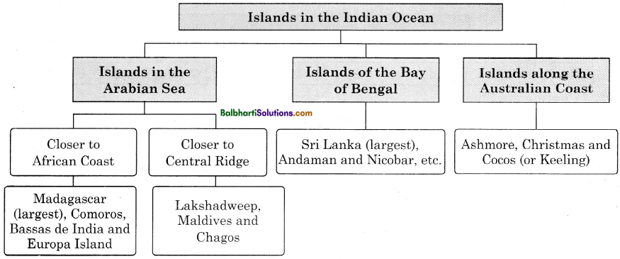
Islands:
land mass surrounded by ocean on all sides.

Maharashtra Board Class 11 Geography Notes Chapter 7 Indian Ocean – Relief and Strategic Importance 4

Distribution of temperature in the Indian Ocean :

  • The study of temperature influences the biotic component in the oceans.
  • Temperature is also largely responsible for the movement in the oceanic water.

Distribution of salinity in the Indian Ocean :

  • Salinity influences the density of the ocean water.
  • It cause the movements in the ocean water.

Temperature : of Indian Ocean water depends on the seasons

Pre-Monsoon Season:

  • summer solstice
  • Temperature increases especially in the southern portion closer to the equator.

South-We st Monsoon Season

  • Temperature is lowered in the Arabian Sea because of monsoonal winds.

North-East

  • Monsoon Season Winter solstice
  • Temperature reduced
  • Northern parts of Bay of Bengal record temperature of about 24°C.

Maharashtra Board Class 11 Geography Notes Chapter 7 Indian Ocean – Relief and Strategic Importance 5

Salinity: Salinity is the measure of amount of salts in the sea water. It is expressed as parts per thousand (%o). Average salinity of sea-water is 35%o.

  • The salinity is generally high around the Somali Peninsula and closer to the Saudi Arabian Coast due to high temperature and low rainfall; there are very few rivers entering into the sea in this area.
  • In the Bay of Bengal, huge discharges from the Ganga system and also from the Peninsular rivers leads to lowering of salinity in this area.
  • Salinity is less in the rainy season.

Ocean Currents in the Indian Ocean :

  • They are affected by Monsoon Wind System, especially in the northern Indian Ocean.
  • They mix waters, transfer heat from one part of the ocean to the other.
  • Indian ocean currents are affected by:
    • Shape of its coastline
    • Extent of coastline
    • Peculiar arrangement of the wind system in the region.

Indian Ocean Currents:

  1. South Equatorial Current
  2. The West Wind Drift

1. The West Wind Drift

  • flows east to west, influenced by easterlies.
  • circulation completed by Mozambique-Agulhas currents

2. South Equatorial Current:

  • flows east to west, to east, influenced by westerlies
  • circulation completed by West Australian Current.

Maharashtra Board Class 11 Geography Notes Chapter 7 Indian Ocean – Relief and Strategic Importance 6

→ In the northern portion of the Indian Ocean, seasonal monsoonal winds drive the currents.

→ These currents mostly follow along the coast lines.

→ During summer they follow in the clockwise direction and during the winter they flow in anticlockwise direction.

Importance of the Indian Ocean :

  • The Indian Ocean region connects three continents namely Asia, Africa and Australia.
  • It supports some of Asia’s biggest economies.
  • It contains three busiest straits — Hormuz, Malacca and Bab-el-Mandeb.
  • Majority of crude oil exported by Gulf countries passes through this route via Strait of Hormuz.
  • The economy of island countries like Maldives and Seychelles located in the Indian Ocean depends upon the marine ecosystem and marine tourism in the Indian Ocean.
  • Indian Ocean region has become important for countries that have military and naval bases, leading to tension in the region.
  • Abyssal plains of the Indian Ocean are a source of nickel, copper, manganese, and cobalt.

Importance of the Indian Ocean for India :

  • The Indian Ocean provides sea routes connecting the Middle East, Africa, and East Asia with Europe and America.
  • It carries heavy traffic of petroleum and petroleum products from the oilfield of the Persian Gulf and Indonesia.
  • Large reserves of hydrocarbons tapped in the offshore areas.
  • Beach sands, rich in heavy minerals and offshore deposits are actively exploited by bordering countries, particularly India.
  • The increasing trade relations with the countries of the East, India has higher stakes in the region in the future.
  • The increasing trade has brought about threats of piracy, armed robbery, and maritime terrorism.

Maharashtra Board Class 12 Political Science Notes Chapter 4 Contemporary India: Challenges to Peace, Stability and National Integration 

By going through these Maharashtra State Board Class 12 Political Science Notes Chapter 4 Contemporary India: Challenges to Peace, Stability and National Integration students can recall all the concepts quickly.

Maharashtra State Board Class 12 Political Science Notes Chapter 4 Contemporary India: Challenges to Peace, Stability and National Integration

Introduction:
Meaning of national integration:
Public order, peace, and stability are crucial requirements for the political, economic, and socio-cultural development of a State. The primary function of the State is maintenance law and order towards the process of national integration.

The role of the State is determined by values of nationalism, secularism, democracy, economic development, and social change. It includes –

→ Peace and Order – One of the key roles of the State is to bring about domestic and international peace and security.

→ Economic Development – The State must be a facilitator of agricultural and industrial growth and the economic well-being of the people.

→ Nation Building – The State is closely associated with the concept of nation integration i.e., diversity of ethnicity, religion, etc. It does not lead to divisive tendencies or disintegration of the State.

→ Governance – This refers to the creation of participatory democracy and good governance based on values like responsiveness, transparency, accountability, equity, etc.

→ Welfare – The State is expected to rectify imbalances in the society such as inequality, injustice, poverty, etc., by applying the principles of social justice, fairness and equality.

→ National integration refers to awareness of a common identity among the people of a nation. It means that though we belong to different races, religions, regions, castes, etc., we recognize the fact that ‘we are one. Today, most countries are facing a problem of national unity, integrity, and consolidation i.e., the problem of bringing about national integration.

National integration involves the reconciliation of socio-cultural,, religious, linguistic, economic diversities to build up a common national identity. It does not try to wipe out sectoral identities or to create a homogeneous society but instead aims to create a territorial nationality. The Indian system can be described as ‘Salad Bowl’ i.e., it is a pluralistic society, where the characteristics of every diversity are maintained but is subordinate to national identity.

Maharashtra Board Class 12 Political Science Chapter 4 Contemporary India: Challenges to Peace, Stability and National Integration

Some common values associated with national integration are –

  1. socio-economic and political justice and equality
  2. secularism and a sense of fraternity among diverse communities
  3. unity in diversity
  4. the feeling of patriotism and loyalty to the nation.
  5. common citizenship

The role of the State in national integration involves

  • evolve certain values and goals that help to maintain social order and stability
  • promote unity among socially and culturally diverse groups living in the territory
  • establish a national authority over the subordinate political units
  • establish a dialogue between the State and people to understand their living conditions, needs, and aspirations.

Indian Situation:
In 1947, when India became independent, it faced problems like social inequalities, economic underdevelopment, and poverty, illiteracy, etc. The main task was to consolidate India’s unity by recognizing India’s ethnic, religious, linguistic diversity. India had to consider two dimensions to promote national integration i.e., structural and psychological dimensions.

Structural Dimension –
This was done through the constitutional process as enumerated below.

→ The democratic system of governance with Universal Adult Franchise to encourage the participation of diverse groups.

→ Constitutional provisions

  • federal structure with a strong central government
  • specification of Fundamental Rights as well as Fundamental Duties
  • 73rd and 74th Amendments strengthened participation of urban and rural local bodies.

→ Linguistic reorganization of States in India (1956) – The 8th Schedule of the constitution lists 22 official languages.

→ At the administrative level, there are All-India Services like IAS, IPS, etc., which provide for a unified central bureaucratic system. There also exists a state-level bureaucratic system.

→ The National Integration Conference (1961) set up the National Integration Council to review issues like communalism, casteism, regionalism, etc., and make recommendations to achieve national integration, equality, justice and secularism.

(2) Psychological Dimension – A feeling of cohesiveness, oneness helps to bind people together. Psychological integration is promoted by common culture/traditions, shared history such as freedom struggle against colonial rule; symbols such as National Flag, National Anthem, National Song, National Emblem, etc.

Maharashtra Board Class 12 Political Science Chapter 4 Contemporary India: Challenges to Peace, Stability and National Integration

The Challenges To National Integration In India:

→ Princely States – There were problems with the integration of princely states of India. Eventually, even Portuguese and French colonies became part of the Indian Union.

→ The problem of North-East States – This region is ethnically very diverse. Maintenance of peace and stability, ensuring industrial and economic development has been a challenge for the Indian system. Nagaland has seen conflicts since independence with militant outfits like NSCN, etc. States like Tripura, Manipur, Mizoram have witnessed militancy. In Assam, the AASU and AGP led the ‘sons-of-the-soil’ movement.

→ Khalistan movement – In Punjab, a Sikh separatist movement for an ‘independent homeland for Sikhs.’ i.e., ‘Khalistan’ arose in the 1980s. Operation Bluestar was conducted against militants hiding in the Golden Temple. This secessionist movement also resulted in the bombing of Air India flight 182 and the assassination of then Prime Minister Smt. Indira Gandhi.

→ Communal issues can be considered as a legacy of the Partition of India. There have been hundreds of cases of religious or sectarian conflicts such as Gujarat riots (1969, 2002), Moradabad (1980). Anti-Sikh riots (1984) following the assassination of Mrs. Gandhi, riots in Mumbai and other parts of the country in 1992-93 following the demolition of Babri Masjid, Muzaffarnagar violence (2013 in UP)

→ Left-Wing Extremism (also called the Maoist movement or Naxalism) has a major support base among landless laborers, Dalits, and tribals who experience a sense of oppression, injustice, and neglect. The first attempt to promote a peasant struggle was the Telangana Movement (1946-51).

→ The Naxal movement originated in 1967 in Naxalbari (West Bengal) led by Kanu Sanyal and inspired by the writings of Charu Majumdar. Since the 1980s, the movement has taken a militant turn.

→ In 2004, CPI (M-L), People’s War Group (PWG), and Maoist Communist Centre of India (MCCI) merged to form CPI (Maoist) which aims to overthrow the government and destroy public property and attack police and officials.

→ The Red Corridor of Naxal activities extends across States like Bihar, Jharkhand, Chhattisgarh, Maharashtra, Telangana, Andhra Pradesh, etc.

Terrorism – It is the actual use or threat to use violence with an intention to disrupt life and create panic. It is called ‘asymmetric’ or ‘indirect’ warfare. It may take the form of the assassination of political figures, hijackings, bombings and attacks on civilians in public transport, etc.

Earlier, terrorism was State-centric e.g., LTTE in Sri Lanka. However, modern-day terrorism aims for abstract ideological or religious goals at the global level e.g., Taliban, Bako Haram, etc.

India has been the target of numerous terrorist attacks e.g., bomb blasts in Mumbai (1993, 2006) and LET attack on 26th Nov 2008 in Mumbai, attack on Parliament (2001), attacks on security forces at Uri (2016) and Pulwama (2019).

Jammu and Kashmir –
In October 1947, Pakistan sent militants to force Maharaja Hari Singh to join Pakistan. However, he signed the Instrument of Accession making Jammu and Kashmir a part of India. This resulted in the first India-Pakistan conflict (1947-48) as India sent troops to protect Kashmir from Pakistani raiders.

→ In 1977, Jammu Kashmir Liberation Front (JKLF) was formed to create an independent State of Kashmir. Pro-Pakistan guerilla groups like Hizbul Mujahideen and Islamic militancy in Kashmir in the 1990s have worsened the situation. Kashmiri Pandits were forced to flee and live in refugee camps. The militants try to radicalize people through social and political groups and make use of social media to incite the youth to indulge in stone-throwing, arson, etc.

→ Terrorist groups like Lashkar-e-Taiba (LeT), Jaish-e-Mohammad (JeM), Harkat ul Mujahideen (HuM), etc., have an active presence in the region. In August 2019, the ‘special’ status of Jammu and Kashmir under Article 370 was revoked and the State was bifurcated into Union Territories of Ladakh and of Jammu and Kashmir.