Key Concepts and Issues Since 1991: Question Answer Class 12 Political Science Chapter 3 Maharashtra Board

Std 12 Political Science Chapter 3 Question Answer Key Concepts and Issues Since 1991: Maharashtra Board

Balbharti Maharashtra State Board Class 12 Political Science Solutions Chapter 3 Key Concepts and Issues Since 1991: Humanitarian Issues Textbook Exercise Questions and Answers.
Class 12 Political Science Chapter 3 Key Concepts and Issues Since 1991: Question Answer Maharashtra Board

Political Science Class 12 Chapter 3 Question Answer Maharashtra Board

1. (A) Complete the following statements by selecting the appropriate option.

Question 2.
Today the Indian approach to gender issues focuses on
(a) Education
(b) Welfare
(c) Development
(d) Empowerment
Answer:
(d) Empowerment

Maharashtra Board Class 12 Political Science Solutions Chapter 3 Key Concepts and Issues Since 1991: Humanitarian Issues

Question 3.
The first UN Conference on Human Environment was held in 1972 in
(a) Johannesburg
(b) Stockholm
(c) Rio
(d) New Delhi
Answer:
(b) Stockholm

(B) Identify the incorrect pair in every set and correct it.

Question 1.
(a) JGSY – Infrastructure development in rural areas
(b) PMKVY – Skill training to youth
(c) MGNREGA – Housing for everyone
Answer:
(c) MGNREGA – assured employment every year for every rural household

Question 2.
(a) National Commission for Women – 1992
(b) Planning Commission – 2015
(c) Rio+20 summit – 2012
Answer:
(b) Planning Commission – 1950

(C) Find the odd word in the given set.

Question 1.
National policy for empowerment of women, protection of women from domestic violence act, Muslim women (protection and right on marriage) Act, the secual harassment at workplace (prohibition prevention and readressal) Act.

Maharashtra Board Class 12 Political Science Solutions Chapter 3 Key Concepts and Issues Since 1991: Humanitarian Issues
Question 2.
Climate change, waste management, water scarity, deforestation.

2. State whether the following statements are true or false with reason.

Question 1.
Planning Commission was created to promote agriculture in India.
Answer:
This statement is False.

  1. The Planning Commission was set up in 1950 to formulate a plan for the effective and balanced utilisation of the country’s resources.
  2. It’s function was to prepare Five Year Plans to tackle poverty, employment and promote the Welfare State. The Green Revolution was introduced to promote agriculture in India.

Question 2.
National Commission for Women was set up to protect rights for women in India.
Answer:
This statement is True.

  1. National Commission for Women was set up to facilitate the redressal of grievances of women.
  2. It aimed to safeguard the rights and legal entitlements of women and accelerate their socio¬economic development.

Maharashtra Board Class 12 Political Science Solutions Chapter 3 Key Concepts and Issues Since 1991: Humanitarian Issues
3. Explain the correlation between the following.

Question 1.
Women Empowerment and Sustainable Development.
Answer:
Empowerment is a process by which any category of oppressed persons gain control over their own lives by developing self esteem and courage to fight against injustice. Sustainable development refers to development using resources in a way that allows for them to renew or to continue to exist for other e.g., recycling materials. This seems almost impossible without gender equality and women’s empowerment. Women are empowered when they are able to access opportunities without restrictions such as in education, career, etc.,

Women’s economic empowerment refers to the ability of women to enjoy their right to control and benefit from resources, income etc as well as the ability to improve their economic status and well-being. Political empowerment includes affirmative action policies to increase participation of women in parliamentary / government positions and policymaking. Thus, women’s empowerment is a key factor for sustainable economic growth, social development and environmental sustainability.

Question 2.
Poverty and Development
Answer:
Poverty refers to deprivation of the basic necessities such as food, clothing, health services, education, etc., that determine quality of life. In economic terms, it is expressed as the poverty line. Development means some measurable improvement in some particular area. Alleviation or even eradication of poverty is the most important aim of developmental work.

Poverty is related to other problems of underdevelopment such as unemployment and inequalities. It hinders economic development as well as leads to issues of health, sanitation and disease, housing, crime, etc. Poverty alleviation i.e., set of economic and humanitarian measures, such as good governance, economic growth, government support in health education etc., are important for development.

Maharashtra Board Class 12 Political Science Solutions Chapter 3 Key Concepts and Issues Since 1991: Humanitarian Issues
4. Answer the following questions in 80 to 100 words.

Question 1.
Explain the traditional and non-traditional perception of poverty.

Question 2.
From 1960’s to 21 century what efforts has India taken to achieve development?

5. Answer the following question with reference to the given points.

Question 1.
Explain condition of women in India.
(a) Economic inequality
(b) Trafficking and exploitation
(c) Literacy rate
(d) Political representation
Answer:
All over the world, women have to face serious problems such as discrimination and violence, under-representation in economic and political decision-making, inequalities in education, health care, landholdings and workplaces and even in human rights.

Some of the important gender issues:
(a) Economic inequality – Participation of women in the labour market is about 28% only.
There is also income inequality due to wide gender wage gaps as well as inequality of opportunities to women e.g., unequal access to education and finance. In many countries, women are either not encouraged to work or employed in the informal sector. Women continue to be underrepresented in high-level, highly paid positions and experience gender discrimination and sexual harassment in the workplace. Women experience high levels of poverty, unemployment and other economic hardships.

(b) Trafficking and exploitation – Women are often exploited and denied basic rights. They are trafficked for purpose of sexual and economic exploitation particularly prostitution, ‘sold’ as brides, subjected to sexual crimes, forced labour, street begging, etc. Trafficking in women means that they are deceived or forced/sold, physically confined, abused with no access to protection or health care.

(c) Literacy rate – low literacy among women is acute in India. As per 2011 census report, female literacy rate is only 65.46% while for males it is 82.14%. The reasons for the low female literacy are-

  1. traditional patriarchal notions that do not consider female education as economically advantageous
  2. Schools in rural areas are not easily accessible and travel may not safe or easy.
  3. Benefits of schemes like R.T.E have not reached many rural females.
  4. Social evils like child marriage, female foeticide, dowry, etc.

(d) Political Representation – Poor political representation of women is a significant gender concern in India. The First Lok Sabha had only 24 women of total 489 members i.e., 5% and the 17th Lok Sabha (2019) has 78 women (14%). This is the highest representation of women in Lok Sabha till date. The Women’s Reservation Bill which proposes to reserve 33% of all seats in Lok Sabha and in State Assemblies for women is pending in the Lok Sabha. However, there exists 33% reservation for women in rural and urban local bodies.

Maharashtra Board Class 12 Political Science Solutions Chapter 3 Key Concepts and Issues Since 1991: Humanitarian Issues
Activity

Question 1.
Find out information on international agreements on environmental balance. (Text Book Page No. 34)
Answer:
1. Stockholm conference (Declaration of UN Conference on Human Environment, 1972) led to a 109 point Environmental Action Plan and establishment of the UN Environmental programme (UNEP).

2. Convention on International Trade in Endangered Species of Wild Flora and Faura (CITES) (1973) – grouped almost 30,000 plant and animal species into three levels of protection depending on the degree of regulation required.

3. Montreal Protocol (1987) – For protection of the ozone layer. It phases out production and use of ozone depleting chemicals.

4. Convention on Biological Diversity (CBD) (1992) – The aim was to promote conservation and sustainable use of biodiversity.

5. Kyoto Protocol (1997) – It supplements the 1992 UN Framework Convention on Climate change (UNFCCC) to limit six greenhouse gas emissions. It involved 37 countries and the UN.

6. Paris Agreement (2016) – It is an agreement within the UNFCCC, dealing with greenhouse gas emissions and strengthening global response to the threat of climate change.

Maharashtra Board Class 12 Political Science Solutions Chapter 3 Key Concepts and Issues Since 1991: Humanitarian Issues
Question 2.
Find out percentage of handicapped voters in 17th Lok Sabha suggest measures to increase their percentage.

Class 12 Political Science Chapter 3 Key Concepts and Issues Since 1991: Humanitarian Issues Intext Questions and Answers

ACTIVITY (Text Book Page No.26)

Question 1.
What are the different initiatives taken by the Indian Government to protect the environment?
Answer:
1. Swachh Bharat Abhiyan was launched on October 2, 2014 to achieve the mission of a clean India in both rural and urban areas. It was implemented by the Ministry of Drinking water and sanitation and the Ministry of Urban Development respectively. Swachh Bharat Mission (Gramin) aims to make India Open Defecation Free (ODF) For Urban Areas, it includes elimination of ODF, eradication of manual scavenging and proper solid waste management.

2. Namami Gange Programme (Clean Ganga Project) is implemented by the National Mission for Clean Ganga to conserve and rejuvenate the river Ganga. The centre allocated a total of Rs 20000 crore for the project. The key achievements include sewerage treatment capacity, river front development and surface cleaning of the river.

3. Green Skill Development Programme was launched in June 2017 by the MoEF and CC. It refers to skills that contribute to preserve and restore the environment, thus enabling youth to be employed or self-employment. Green skills include Pollution Monitoring, Waste Management, Forest and Wildlife Management, etc.

4. Constitutional Provisions – Article 48 (DPSP) says the State shall endeavour to protect and improve the environment. Article 51-A States that it shall be the duty of every citizen of India to protect and improve the natural environment.

5. Legislation – (i) Indian Wild Life Protection Act (1972) Forest Conservation Act (1980) and Environment (Protection) Act (1986)
(ii) National Environmental Policy (2006) Ministry of Environment, Forest and Climate change (MoEF and CC) along with Pollution Control Boards administer and enforce environmental laws. There is also the National Green Tribunal.

Maharashtra Board Class 12 Political Science Solutions Chapter 3 Key Concepts and Issues Since 1991: Humanitarian Issues
Question 2.
Salient Features of National Policy for Women (2016). (Text Book Page No.33)
Answer:
National Policy for Women was unveiled by Union WCD Minister, Smt Maneka Gandhi on 17th May 2016. It will replace National Policy for Empowerment of Women (2001). It shifts the focus from entitlements to rights and from mere empowerment to creating an enabling environment for women. It seeks to create conducive socio-cultural, economic and political environment to enable women to enjoy fundamental rights and realize their full potential. It’s priority areas include health, food security and nutrition, education, involving women in governance and decision making, encouraging entrepreneurship, facilitating women in the workplace and dealing with violence against women.

Question 3.
Find out information on international agreements on environmental balance. (Text Book Page No. 34)
Answer:
1. Stockholm conference (Declaration of UN Conference on Human Environment, 1972) led to a 109 point Environmental Action Plan and establishment of the UN Environmental programme (UNEP).

2. Convention on International Trade in Endangered Species of Wild Flora and Faura (CITES) (1973) – grouped almost 30,000 plant and animal species into three levels of protection depending on the degree of regulation required.

3. Montreal Protocol (1987) – For protection of the ozone layer. It phases out production and use of ozone depleting chemicals.

4. Convention on Biological Diversity (CBD) (1992) – The aim was to promote conservation and sustainable use of biodiversity.

5. Kyoto Protocol (1997) – It supplements the 1992 UN Framework Convention on Climate change (UNFCCC) to limit six greenhouse gas emissions. It involved 37 countries and the UN.

6. Paris Agreement (2016) – It is an agreement within the UNFCCC, dealing with greenhouse gas emissions and strengthening global response to the threat of climate change.

Maharashtra State Board 12th Std Political Science Textbook Solutions

Key Concepts and Issues Since 1991: Globalisation Question Answer Class 12 Political Science Chapter 2 Maharashtra Board

Std 12 Political Science Chapter 2 Question Answer Key Concepts and Issues Since 1991: Globalisation Maharashtra Board

Balbharti Maharashtra State Board Class 12 Political Science Solutions Chapter 2 Key Concepts and Issues Since 1991: Globalisation Textbook Exercise Questions and Answers.
Class 12 Political Science Chapter 1 Key Concepts and Issues Since 1991: Globalisation Question Answer Maharashtra Board

Political Science Class 12 Chapter 1 Question Answer Maharashtra Board

1. (A) Choose the correct alternative and complete the following statements

Question 1.
In 1995, GATT was replaced by the
(a) WTO
(b) ECOSOC
(c) UNDP
(d) TRIPS
Answer:
(a) WTO

Maharashtra Board Class 12 Political Science Solutions Chapter 2 Key Concepts and Issues Since 1991: Globalisation
Question 2.
……………… refers to a company that operates in several countries but has a distinct home base
(a) Transnational Corporation
(b) Mixed Economy
(c) Multinational Company
(d) Liberalism
Answer:
(c) Multinational Company

(B) Find the odd word.

Question 1.
Mobile, Satellite, Internet, Gramophone.
Answer:
Gramophone (not functioning on modern technology)

(C) State the appropriate concept for the given statements.

Question 1.
The international agency dealing with international trade.
Answer:
World Trade Organization (WTO)

Question 2.
The companies that operate in several countries.
Answer:
Multi National Companies

Maharashtra Board Class 12 Political Science Solutions Chapter 2 Key Concepts and Issues Since 1991: Globalisation
(D) Identify the incorrect pair in every set and correct it.

Question 1.
(a) Nestle – Trans National Corporation
(b) Copyrights – Intellectual Property
(c) India – Capitalist Market Economy
Answer:
(c) USA – Capitalist Market Economy
OR India – Economic Liberalism (Mixed economy)

Question 2.
(a) Amnesty International – Human Rights
(b) Green Peace – Environmental Issues
(c) Chernobyl – Trade Agreement
Answer:
(c) Chernobyl – Nuclear disaster

2. State whether the following statements are true or false with reason.

Question 1.
Globalisation brought in the concept of market economy.
Answer:
This statement is True.
(i) During the Cold War, the economic systems followed by countries, depended upon their ideology. For e.g., most West European nations and the USA were free democracies and followed capitalist economy.

(ii) In the era of globalisation there is only ‘market economy’. However, the nature of market economy is determined by the countries ideology for e.g., China has a socialist market economy, West European nations are described as ‘welfare market economies’ and USA is considered as ‘capitalist market economy’.

(iii) In most countries, the State has with draws from economic activities and the private sector and profit motive has propelled the economy.

Maharashtra Board Class 12 Political Science Solutions Chapter 2 Key Concepts and Issues Since 1991: Globalisation
Question 2.
Non-state actors have become irrelevant in the age of globalisation.
Answer:
This statement is False.
(i) Good governance and the participatory State focus on the role of the civil society which includes non-state actors such as NGO’s.

(ii) International relations today, are not only between States but also include non-state actors. These sometimes also pose a challenge to the position of the State. Globalisation has made non-state actors relevant. This includes organisations which are beneficial e.g., NGO’s working for humanitarian issues as well as threatening organisations e.g., terrorist outfits.

3. Explain the correlation between the following.

Question 1.
Globalisation and culture
Answer:
Globalisation refers to the rapid spread of goods and services, technology and information, ideas and culture, trade and interactions across the world. It is the connection of different parts of the world resulting in the expansion of international cultural, informational, economic and political activities. Events in one part of the world have an impact on other parts of the world. Changes have taken place economically and culturally.

Today a ‘global cosmopolitan culture’ has emerged i.e movement of people across the world and public awareness of global issues. This is noticed in matters like values eg secularism, clothing food choices, ways of celebrating festivals, etc. There is international awareness of India’s rich cultural and historical heritage. Similarly, westernisation and urbanisation have influenced Indian society eg breakup of the traditional joint family and rise of individualism and materialism in the country.

Maharashtra Board Class 12 Political Science Solutions Chapter 2 Key Concepts and Issues Since 1991: Globalisation
Question 2.
GATT and WTO
Answer:
The General Agreement on Tariffs and Trade (GATT) was signed on 30th October 1947 by 23 countries with the purpose to promote international trade by reducing/eliminating trade barriers such as tariffs or quotas. It came into force on 1st January 1948. It aimed to boost economic recovery after World War II through reconstructing and liberalizing global trade. It introduced the most favoured nation principle. GATT was refined over 8 rounds of negotiations, leading to creation of World Trade Organization (WTO) which replaced GATT on 1st January 1995.

WTO covers services and intellectual property also. It is the international agency overseeing the rules of international trade i.e., it promotes free trade agreements, organizes trade negotiations, settles trade disputes, etc. It’s headquarters is in Geneva. It has 123 member States. The WTO dispute settlement system is faster, more automatic than the GATT system and it’s rulings cannot be blocked.

4. Express your opinion of the following.

Question 1.
Participatory State is beneficial to the society.
Answer:
Participatory State advocates more involved forms of citizen participation and greater political representation than traditional representative democracy. It goes beyond traditional democratic practices wherein decisions are made by the majority. In a participatory State, all sections of the society are involved in the making of policy. Participatory State is beneficial as it gives citizens a central role in public policy through public discussion, negotiations, voting, etc. It emphasizes the importance of making citizens aware and providing for a form of communication which promotes political dialogue.

Maharashtra Board Class 12 Political Science Solutions Chapter 2 Key Concepts and Issues Since 1991: Globalisation

5. Answer the following question in 80 to 100 words.

Question 1.
What are the positive and negative aspects of Globalisation?
Answer:
Globalisation refers to the rapid spread of goods and services, technology and information, ideas and culture, trade and interactions across the world. It is the connection of different parts of the world resulting in the expansion of international cultural, informational, economic and political activities. In the early 1990s, the term globalisation was used to include economic, political, socio¬cultural, technological and ideological changes that occurred in the world in the post cold war era. The world has become more interconnected due to advances in technology and communication. Events in one part of the world have an impact on other parts of the world. Changes have taken place economically and culturally.

The Positive aspects of globalisation are-

  1. It creates more employment opportunities.
  2. It encourages free trade.
  3. It leads to better choice of goods and services to the consumer.
  4. It leads to wider investments in developing countries.
  5. It enhances efficiency of the tertiary sector i.e., banking and finance.
  6. It increases purchasing power of citizens and enhances their standard of living.
  7. It increases labour productivity and reduces capital-output ratio.
  8. It helps to increase efficiency in the production system.

The negative aspects of globalisation are-

  1. Globalization promotes technological adaption to increase productivity but has also resulted in loss of jobs.
  2. Local/small scale industries cannot withstand competition from the MNC’s and may be bought off or shut down.
  3. Less developed countries may become dependent on the technologically superior countries.
  4. It has caused specialization of labour and so there are few employment opportunities for unskilled labour.
  5. It has led to increased gap between rich and poor nations.
  6. It may lead to overexploitation of resources and negatively impact the environment.
  7. It leads to the harmful effects of consumerism.
  8. It may lead to reduction in social welfare schemes in both developed and developing countries.

Activity

Talk to people of the older generation to find out what changes have taken place in the age of globalisation.

Maharashtra Board Class 12 Political Science Solutions Chapter 2 Key Concepts and Issues Since 1991: Globalisation
Class 12 Political Science Chapter 2 Key Concepts and Issues Since 1991: Globalisation Intext Questions and Answers

Activity (Text Book Page No. 18)

Question 1.
What has been the impact of globalisation on the Indian agricultural sector, especially the small farmer?
Answer:
Globalisation has both positive and negative consequences on Indian agriculture.
The positive consequences are-
(i) Availability of modern agro technologies in pesticides / herbicides, fertilizers, new varieties of high yield seeds to increase food production.
(ii) There are new markets for agricultural products.
(iii) Farmers can sell their goods directly to companies and eliminate the role of middlemen.

The negative effects of globalisation on agriculture are-

  1. Farmers are shifting from traditional / mixed cropping to unsustainable cropping practices mainly for cash crops.
  2. MNC’s have captured the India market, making farmers dependent on expensive HYV seeds, fertilizers, etc.
  3. Small and marginal farmers may not be able to avail of the advantages of globalisation. They may be pushed into debt leading to tragic consequences like farmer suicides.

Maharashtra Board Class 12 Political Science Solutions Chapter 2 Key Concepts and Issues Since 1991: Globalisation
Question 2.
Find out what the Arab Spring movement was and how social networking was used during that movement. (Text Book Page No. 21)
Answer:
Arab Spring was a series of protests and uprisings against the governments that spread across large parts of the Arab world in the early 2010s. (i.e. December 2010 to December 2012). It began with protests in Tunisia and spread quickly to other countries like Libya, Egypt, Yemen, Syria and Bahrain. There were riots, civil wars and the main slogan of protestors was “the people want to bring down the regime”.

There were sustained street demonstrations in Iraq, Algeria, Morocco, Jordan, Lebanon, etc. The social media i.e. facebook, etc. was the driving force behind the swift spread of the revolutions. The results of these movements were that regimes of Tunisia (Abidine Ben Ali), Egypt (Hosni Mubarak) Libya (Gaddafi), Yemen (Abdullah Saleh) were ousted while in Syria, Iraq, etc., a full scale civil war resulted. Only in Tunisia, there was a transition to constitutional democratic government.

Question 3.
Find out cases where agitations have used social networking to highlight their demands. (Text Book Page No. 21)
Answer:
Social networking and micro media have aided many protests and agitations. Some examples are:
(i) Arab Spring movements (2010-2012) used media power eg., Facebook to over throw despotic rulers e.g., Gaddafi in Libya or Hosni Mubarak in Egypt.

(ii) In India, the Anti-Corruption Movement led by Anna Hazare (2011) was helped by extensive media coverage and social media posts specially among the youth and students.

(iii) Social networking played a vital role in the “Me Too” movement all over the world to expose workplace sexual harassment especially in the glamour industry.

(iv) Social networking played a major role in galvanising support during the pro-democracy demonstrations in Hong Kong.

(v) Various social media handles fuelled the protests against NRC, CAA, etc., in various States of India.

Maharashtra Board Class 12 Political Science Solutions Chapter 2 Key Concepts and Issues Since 1991: Globalisation
Question 4.
Can the cooperative movement of India be an answer to the domination of multinational and transnational companies? The philosophy of the cooperative movement is to provide both, empowerment and finance to the members while that of the corporations work on profit motive. Give your opinion on this. (Text Book Page No. 17)
Answer:
Cooperative Movement in India can be traced to the Cooperative Credit Societies Act (1904). India’s first Prime Minister, Jawaharlal Nehru had strong faith in the cooperative movement. Hence, cooperatives became an integral part of Five Year Plans in India. In 1958, National Development council recommended setting up of Cooperative Marketing Societies. The major sectors where cooperatives dominate are in dairy, agriculture, banking and rural credit, etc. Article 43, Part IV (DPSP) of the constitution, mentions about promotion of cooperatives mainly in rural areas.

The importance of the cooperative sector.

  • it provides agricultural credits where the State and private sectors have not been able to do so.
  • it helps to overcome the constraints of agricultural development.
  • it provides empowerment to the members.
  • it can be an answer to the domination by the MNC’s which work solely on the profit motive. If the problems of cooperatives are overcome, they can strengthen the financial sector and lessen our reliance on MNC’s.

Maharashtra State Board 12th Std Political Science Textbook Solutions

Population Part 1 Question Answer Class 12 Geography Chapter 1 Maharashtra Board

Std 12 Geography Chapter 1 Question Answer Population Part 1 Maharashtra Board

Balbharti Maharashtra State Board Class 12 Geography Solutions Chapter 1 Population Part 1 Textbook Exercise Questions and Answers.

Class 12 Geography Chapter 1 Population Part 1 Question Answer Maharashtra Board

Geography Class 12 Chapter 1 Question Answer Maharashtra Board

1. Identify the correct correlation.

A – Assertion R – Reasoning
Question 1.
A – Areas which have fertile soil have dense population.
R – Fertile soils are good for agriculture.
(a) Only A is correct.
(b) Only R is correct.
(c) Both A and R are correct and R is the correct explanation of A.
(d) Both A and R are correct but R is not the correct explanation of A.
Answer:
(c) Both A and R are correct and R is the correct explanation of A.

Question 2.
A – Population of a region does not change.
R – Birth rate, death rate and migration affect the population of a region.
(a) Only A is correct.
(b) Only R is correct.
(c) Both A and R are correct and R is the correct explanation of A.
(d) Both A and R are correct but R is not the correct explanation of A.
Answer:
(b) Only R is correct.

Maharashtra Board Solutions

Question 3.
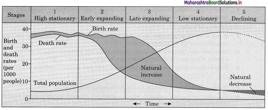
A – In stage 2, death rate reduces but birth rate is constant.
R – Population increases rapidly in stage 2.
(a) Only A is correct.
(b) Only R is correct.
(c) Both A and R are correct and R is the correct explanation of A.
(d) Both A and R are correct but R is not the correct explanation of A.
Answer:
(c) Both A and R are correct and R is the correct explanation of A.

Question 4.
A – In stage 5 death rate is more than birth rate.
R – Population is declining in stage 5.
(a) Only A is correct.
(b) Only R is correct.
(c) Both A and R are correct and R is the correct explanation of A.
(d) Both A and R are correct but R is not the correct explanation of A.
Answer:
(c) Both A and R are correct and R is the correct explanation of A.

Question 5.
A – In stage 1 both death rate and birth rate are high.
R – Population growth is stable in stage 1.
(a) Only A is correct.
(b) Only R is correct.
(c) Both A and R are correct and R is the correct explanation of A.
(d) Both A and R are correct but R is not the correct explanation of A.
Answer:
(c) Both A and R are correct and R is the correct explanation of A.

2. Write short notes on.

Question 1.
Impact of relief on population distribution.
Answer:
1. Relief is one of the most important factors influencing the distribution of population.

2. Generally, mountains are thinly populated, plains are thickly populated and plateaus are moderately populated.

3. The mountains and hilly areas are less populated because of limited means of livelihood; agriculture is poorly developed and transportation facilities are limited. For example, north eastern states of India have less population due to hilly and mountainous relief.

4. On the other hand, plains are densely populated because of fertile soil and well-developed agriculture. Due to plain relief, it is easy to construct roads and develop industries. Better employment facilities attract people in these areas. For example, Ganga plains are thickly populated.

5. In short, we can say plains are densely populated and mountains and plateaus are sparsely populated.

Maharashtra Board Solutions

Question 2.
Correlation between birth rate and death rate.
Answer:

  • Birth rate and death rate are the important components of population change.
  • Birth rate is the number of live births in a year per thousand population.
  • Death rate is the number of deaths in a year per thousand population.
  • Population growth depends upon birth rate and death rate in a year.
  • Population growth occurs not only by increasing birth rate but also because of decreasing death rate.
  • When birth rate is more than death rate, population increases.
  • When birth rate is less than death rate, population decreases.
  • If both, birth rate and death rate is same then population is said to remain stable. However, the birth rate and death rate being same is only a hypothetical situation.

Question 3.
Stage 3 of Demographic Transition Theory.
Answer:
1. Stage 3 of Demographic Transition Theory is the stage of expanding population.

2. From second stage to this stage, death rates are decreasing. Birth rates are also decreasing. Decrease in both birth rates and death rates, reduces the rate of growth of population. But actually, population is growing because the birth rates are higher than death rates.

3. In this stage, since the country is making progress, the income of the people is above the subsistence level and there is an improvement in the standard of living of the people. Poverty is also reducing.

4. There is development of technology as a result secondary and tertiary activities develop.

5. Due to increase in education level, people understand the importance of family planning so size of family reduces.

6. In short in stage 3 countries are moving from developing stage to developed stage.

3. Give geographical reasons.

Question 1.
India is passing through Stage 3 of demographic transition.
Answer:

  • In India, since there is a decrease in the birth rates and death rates, the growth rate of population is also decreasing.
  • Due to the development in the country, income of the people has reached above subsistence level, standard of living is improved, poverty is decreasing, technology is developing.
  • Number of people engaged in secondary and tertiary activities are increasing.
  • Due to increase in the literacy rate, people have understood the importance of family planning. Therefore, there is a decrease in the size of family.
  • Hence, India is passing through Stage 3 of demographic transition.

Question 2.
Population distribution is uneven.
Answer:
1. Distribution of population in the world is very uneven because distribution of population depends upon many physical factors such as relief, climate, availability of water supply, soil etc.

2. For example, if you consider relief factor, mountains and hilly areas are thinly populated. Plateau regions are moderately populated and plains are densely populated. The Himalayan region in India is thinly populated but the Gangatic plains are thickly populated and Deccan plateau region are moderately populated.

3. The distribution of population also depends upon human factors such as agriculture, mining, transportation, urbanisation etc.

4. For example, agriculture or mining activities support large population since they provide source of living to many people.

5. Sometimes government policies also affect population distribution. For example, government provided land, water, electricity at concessional rate in New Mumbai area to attract people and to reduce pressure of population in Mumbai city.

Question 3.
Population increases because of transportation facilities.
Answer:
1. The development of roads and railways makes the region more accessible.

2. Such areas provide favourable conditions for the development and manufacturing industries, which generate employment. Therefore, people from different areas migrate in search of jobs. Thus, such areas become densely populated. For example, Gangetic plain of India, where the density of roads and railways is highest in India.

3. Population increases in port cities due to availability of sea transport for the development of trade. Therefore, the coastal region is densely populated. For example, many port cities like Chennai, Mumbai are developed on the east and west coast of India.

4. Thus, population increases because of transportation facilities.

Maharashtra Board Solutions

Question 4.
Secondary and tertiary activities increase in the third stage of demographic transition.
Answer:

  • In Stage 3 of demographic transition theory, growth rate of population decreases.
  • As a result, the income of the people in the country reaches above subsistence level. Poverty rate decreases and standard of living increases. Therefore, the use of technology increases and this generates an employment in secondary and tertiary activities.
  • Due to increase in education level and development of health facilities there is increase in employment in tertiary sector.
  • Thus, secondary and tertiary activities increase in the third stage of demographic transition.

Question 5.
Population may increase though birth rates are low.
Answer:
The growth of population depends upon the difference between number of live births in a year per thousand population and number of deaths in a year per thousand population. Therefore, growth of population depends upon both birth rate and death rate.

When birth rate is low and death rate is also low, then though the number of live births per thousand population are less, but due to a smaller number of deaths per thousand population, there is increase in population of the country.

Question 6.
Population density is a function of population and area of a region.
Answer:
The number of people living in any area or country is called total population of the area or country.

Density of population is the ratio between total population and a total area of that region or country.

For example, as per the census of 2011, Density of population in India is 325 persons per sq. km. It is a ratio between total population in India and total area of India in sq. kms.

In some countries total population may be less but the density of population is high due to small area of the country. For example, Bangladesh’s total population is less but area of country is small therefore, density of population is high.

In some countries total population may be more but the density of population is low due to very large area of the country. For example, Brazil has more total population but area of country is also large therefore, density of population is low.

Thus, population density is a function of population and area of a region.

4. Answer the following questions in detail.

Question 1.
Explain the physical factors affecting distribution of population.
Answer:
Physical factors affecting distribution of population are:
(i) Relief
(ii) Climate
(iii) Availability of water
(iv) Soils

(i) Relief

  • Distribution of population is greatly affected by relied features.
  • Generally, flat plains or gently sloping lands are densely populated.
  • Plains are suitable for agricultural activities.
  • In these areas it is easier to construct roads and railways and development of industries and trade. As a result, many people are attracted to plains and they become densely populated. For example, Ganga plains are thickly populated.
  • On the other hand, in mountainous and hilly areas density of population is low. This is because in such areas agricultural development is difficult.
  • The construction and development of transport facilities is very difficult and costly too. Such areas are inaccessible.
  • Due to inaccessibility, movement of goods and people are restricted. Therefore, mountainous and hilly areas are thinly populated. For example, north eastern states of India have less population due to hilly and mountainous relief.

(ii) Climate

  • Climate is the most important factor of all the factors influencing the distribution of population.
  • Areas having very hot or very cold climate, heavy rainfall are very uncomfortable for human settlement. Such areas are thinly populated.
  • For example, polar regions where Eskimos and Lapps live are sparsely populated due to extreme cold climate. Sahara Desert is sparsely populated due to extreme hot climate.
  • On the other hand, areas with equable climate, that is climate having not much seasonal variation attract people. People feel comfortable to stay in these areas.
  • For example, coastal areas have dense population because of equable climate and wide scope for the development of agriculture, industries and trade.

(iii) Availability of water

  • Water is the most important factor affecting distribution of population. It is the most essential factor for all human activities.
  • Therefore, more people live in areas where potable and sufficient water is available. As a result of this most of the river valleys are densely populated i.e. Nile river valley.
  • Even in desert areas there is more population near oasis due to availability of water.

(iv) Soil

  • Fertile soils are most important for the development of agriculture.
  • The areas having fertile alluvial soil have developed intensive agriculture and support large number of people and hence they are densely populated, e.g., Gangetic Plain, Plains of Mississippi, Irrawaddy and Yangtze etc.
  • Similarly, in the areas having very fertile black cotton soil or regur soil, agriculture is well developed and hence such areas are densely populated.
  • The volcanic soil is very fertile hence, it supports agriculture. Therefore, slopes of volcanic mountains have dense population. For example, volcanic mountain slopes of Java island.

Maharashtra Board Solutions

Question 2.
In the first and fifth stage of the demographic transition, population growth is almost nil. What is the difference between the two stages then?
Answer:

  • In the stage 1 both birth rates and death rates are high. The difference between the two is very less and therefore, population is stable.
  • In stage 1 birth rates are high due to limited educational opportunities, people feel having many children is good. Therefore, families are big.
  • In stage 1, due to lack of sanitation facilities, medical facilities, spread of contagious diseases, malnutrition, etc., death rate is high.
  • In stage 5 birth rates and death rates are very low. Birth rates are almost equal to death rates.
  • As a result, the population growth is almost minimal or very low or even negative in case of some countries.
  • In stage 5, death rate is low because of improved medical facilities, eradication of contagious diseases and healthy environment.
  • In stage 5, due to increase in awareness among the people, birth rate is low.

Question 3.
Discuss the problems faced by counties in stage 4 and stage 5.
Answer:
Problems faced by stage 4 countries are as under:

  • The death rate is very low and going down as the medical facilities have improved and pandemic like plague, cholera, small pox, etc., are eradicated.
  • Birth rate is the same as death rate so population growth is minimal.
  • Problems faces by stage 5 countries are as under:
  • In this stage the birth rate is very low and death rate is high. Therefore, the growth of population is slow or negative growth of population is seen.
  • Due to large number of old people the death rate is high and due to a smaller number of young people birth rate is low.
  • Due to large number of old people, dependent population is high.
  • Due to less young age population, working population is limited.
  • As a result, the size of dependant population is larger than active population and it has adverse effect on economy of the country.

5. Draw a neat labelled diagram for demographic transition theory and its various stages.
Answer:
Maharashtra Board Class 12 Geography Solutions Chapter 1 Population Part 1 1

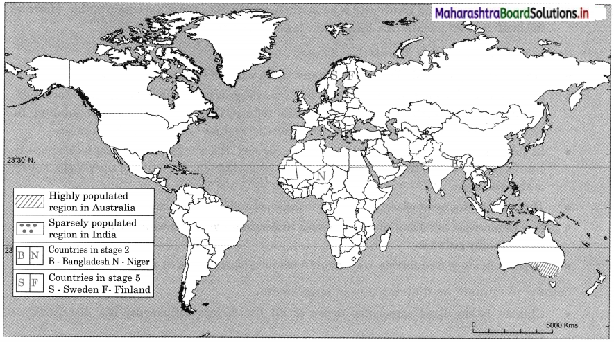
6. Mark and name the following on the outline map of the world with suitable index.

(a) Highly populated region in Australia.
(b) Sparsely populated region in India.
(c) Any 2 countries in stage 5 of demography transition theory.
(d) Any 2 countries in stage 2 of demographic transition theory.
Answer:
Maharashtra Board Class 12 Geography Solutions Chapter 1 Population Part 1 2

Class 12 Geography Chapter 1 Population Part 1 Intext Questions and Answers

Try These

Question 1.
Observe the pie charts shown in the figure and answer the following questions. (Text book pg.no – 1)
Maharashtra Board Class 12 Geography Solutions Chapter 1 Population Part 1 3

  1. Which continent has least population?
  2. Which continent has the least landmass and also least population?
  3. Which continent has the most land mass as well as most of the population?
  4. Which continent is missing in one of the pie charts? Why?

Answer:

  1. The continent which has the least population is Australia.
  2. The continent which has the least land mass and also least population is Australia.
  3. The continent which has the most land mass and also most population is Asia.
  4. The continent of Antarctica is missing in population distribution chart, because it has no permanent human settlement.

Maharashtra Board Solutions

Question 2.
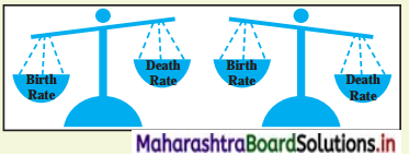
Look at the below figure and answer the questions that follow:
Maharashtra Board Class 12 Geography Solutions Chapter 1 Population Part 1 4

  1. What does the image show?
  2. What happens to the population when the deaths are more than births?
  3. What happens to the population when births are more than deaths?
  4. What happens when both are same? Is it possible?

Answer:

  1. The image shows balance between birth rate and death rate.
  2. Population growth may be less or in some countries there may be negative growth.
  3. When births are more than deaths, then population growth is faster.
  4. When both births and deaths are same, population will be stagnant. This is not possible for any country.

Give it a try

Question 1.
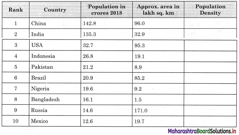
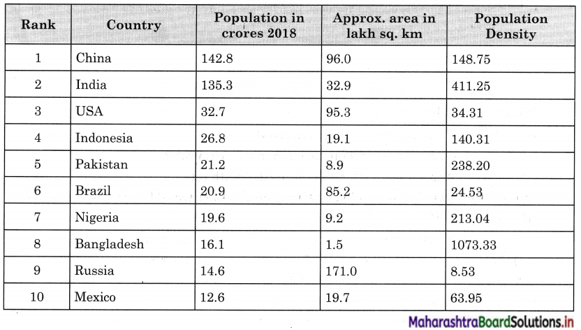
The below table shows the 10 most populated countries in the world in 2018 with their areas. Calculate their population densities and complete the table. (Text book pg.no – 1)
Maharashtra Board Class 12 Geography Solutions Chapter 1 Population Part 1 5
Answer:
Maharashtra Board Class 12 Geography Solutions Chapter 1 Population Part 1 6

Question 2.
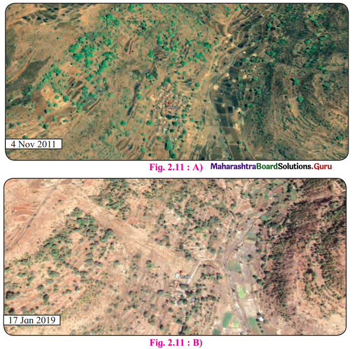
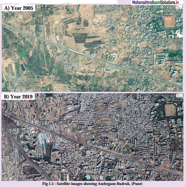
The satellite image given in Fig. They show the same area from two different periods. (Text book pg.no – 6)
Maharashtra Board Class 12 Geography Solutions Chapter 1 Population Part 1 7

  1. What difference do you see?
  2. What might have caused these changes?

Answer:
1. The satellite image ‘A’ is image of the year 2005 and satellite image ‘B’ is of the year 2019. That means there is a difference of 14 years in these two images.

2. In image ‘A’ you can see that there are a few roads, limited settlements and most of the areas are covered by agricultural fields, and there is thin population.

3. When we compare the image ‘A’ with the image ‘B’, we find that in image ‘B’ the number of major roads (highway) and minor roads have increased. As a result, the area has become more accessible and thickly populated.

Due to development of industries and employment opportunities there is development of transport.

Maharashtra Board Solutions

Question 3.
1. Can you calculate the death rate if the total number of deaths in the above city was 2,986 in the same year?
2. On the basis of the birth rates given in earlier and death rates calculated, what change in population do you observe?
Answer:
1. Total population of a city is 223000 and total deaths in the city are 2986 in that year.
Death Rate = \(\frac {Total number of deaths in a year}{Total population in that year}\) × 1000
Death Rate = \(\frac {2896}{223000}\) × 1000 = 13.39
Therefore, the death rate is 13.39.

2. In earlier example birth rate was 14.57 and the death rates calculated is 13.39. It means death rate have decreased by 1.8. It means the population has increased.

Question 4.
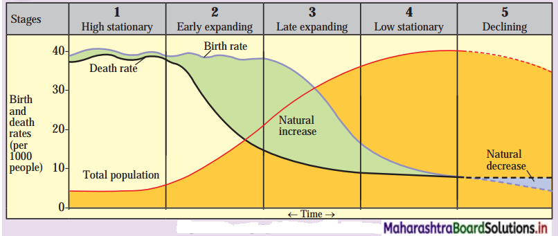
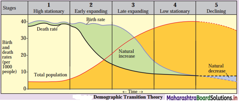
Look at the graph in Fig. carefully. Answer the following questions: (Text book pg.no – 9)
Maharashtra Board Class 12 Geography Solutions Chapter 1 Population Part 1 8

  1. What do the blue and black lines indicate?
  2. What does the green part in the graph show?
  3. What does the blue part in the graph show?
  4. In which stages is the birth rate more than the death rate?
  5. In which stages is the birth rate same as the death rate?
  6. In which stage is the death rate being more than birth rate?

Answer:

  1. Blue lines indicate birth rate and black lines indicate death rate.
  2. Green part in the graph shows the natural increase of population.
  3. Blue part in the graph shows the natural decrease of population.
  4. In stage 2 and 3 birth rates is more than death rate.
  5. In stage 4 the birth rate is same as the death rate.
  6. In stage 5 the death rate is more than birth rate.

Make friends with maps!

Question 1.
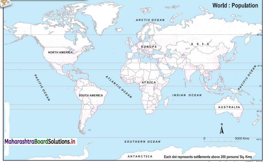
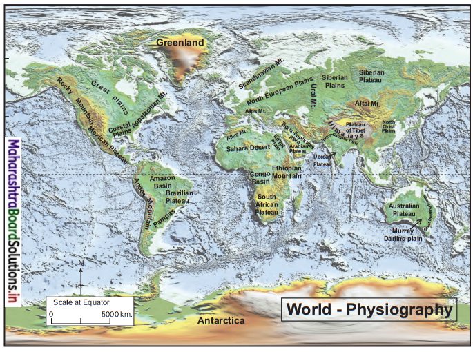
Look at the map in Fig. Compare it with the physical map of the world given in Textbook Page No. 83. Try to understand the impact of physical factors on population distribution. Complete the table accordingly. (Text book pg.no – 2)
Maharashtra Board Class 12 Geography Solutions Chapter 1 Population Part 1 9
Maharashtra Board Class 12 Geography Solutions Chapter 1 Population Part 1 10
Answer:

ContinentPhysical factors responsible for High populationPhysical factors responsible for less population
North AmericaCoastal AreasForest, deserts, snow covered land
AsiaCoastal areas and Fertile PlainsMountains and deserts
EuropeCoastal areas and fertile PlainsMountains, snow covered areas
AfricaCoastal AreasDense forest, mountains and deserts
South AmericaCoastal AreasMountains, dense forest and deserts
AustraliaCoastal AreasHilly regions and deserts
AntarcticaSnow covered areas

Question 2.
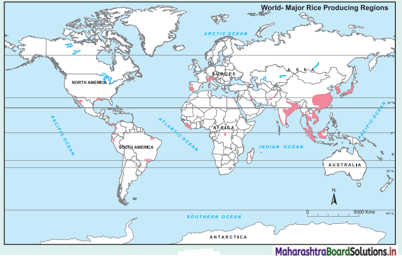
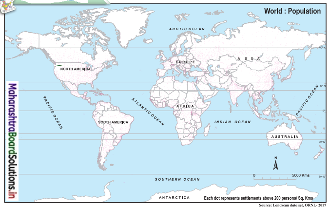
Refer to the map showing rice producing regions of the world in Fig. Relate it with the population map of the world in Fig. Write the conclusions in your own words. (Text book pg.no – 5)
Maharashtra Board Class 12 Geography Solutions Chapter 1 Population Part 1 12
Maharashtra Board Class 12 Geography Solutions Chapter 1 Population Part 1 13
Answer:
Areas of high density of population in Fig 1.2 if we compare with world map Fig 1.4 showing major rice producing areas in the world, we found that the areas of major rice production and areas of high density / thick population are the same areas.
Conclusion:
Rice cultivation is possible only in those areas where there is fertile alluvial soil and assured supply of water.
Rice producing areas and areas of dense population in the world are the river flood plains and delta of rivers like Kaveri, Krishna, Godavari and Ganga in India, Brahmaputra in Bangladesh, Irrawaddy in Myanmar, Yangtze and Yellow in China, Mekong in Laos and Cambodia etc. These areas are high density areas in the world.

Maharashtra Board Solutions

Can you tell?

Question 1.
Can you think of the factors besides physiography which affect the distribution of population? Make a list. (Text book pg.no – 3)
Answer:

Physical / Human factorsHigh density of populationLow density of population
Availability of potable waterRiver valleysDeserts
ClimateEquable climate – coastal areasExtreme climate – polar regions
Availability of resourcesMinerals, fertile soilLimited resources
EconomicTransportation, employment opportunities, urbanisationLess employment opportunities, poor economic growth
SocialMigration from different parts of India in MumbaiOut migration from Konkan to Mumbai
Government PolicyFavourable government policies to attract peopleUnfavourable government policies

Question 2.
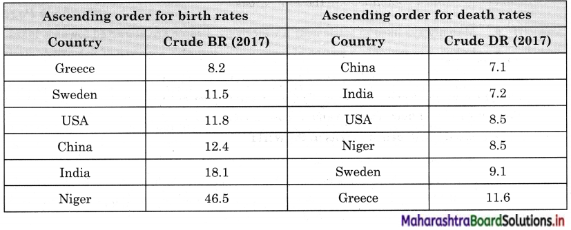
Observe the table 1.4. Arrange data in ascending order for birth rate and death rates respectively. (Text book pg.no – 8)

CountryCrude BR (2017)Crude DR (2017)
Sweden11.59.1
India18.17.2
Greece8.211.6
China12.47.1
USA11.88.5
Niger46.58.5

Answer:
Maharashtra Board Class 12 Geography Solutions Chapter 1 Population Part 1 16

Question 3.
Look at the Fig. and answer the following questions. (Text book pg.no – 9)
Maharashtra Board Class 12 Geography Solutions Chapter 1 Population Part 1 17

  1. If the crude birth rate is 7 and crude death rate is 8 then which stage of demographic transition is the country in?
  2. If a country has crude death rate of 20 and crude birth rate of 24, then which stage of demographic transition is the country in? [Text book pg.no – 10]

Answer:

  1. The country is in stage 5 of demographic transition.
  2. The country is in stage 3 of demographic transition.

Find out.

Question 1.
(i) Are Eskimos still living in their conventional ways?
(ii) What changes can be seen in their lifestyle now? (Text book pg.no – 4)
Answer:
(i) No, Eskimos are not living in their conventional way due to the changing environment as a result of increased contacts with societies to the south.

(ii) Eskimo life has changed greatly because of increased contacts with societies to the south.

  • They were using harpoons for hunting, now they are using rifles. They were using dogs for land transport, now they are using snowmobiles.
  • Outboard motors, store-bought clothing and many other manufactured products have entered into their culture.
  • Women are taking salaried jobs to earn currency for store-bought products. As a result, women are losing their knowledge of traditional skills such as sewing animal skin.
  • Many Eskimos are not doing nomadic hunting which was their main activity. Now they are living in northern towns and cities and working in mines and oil fields.
  • Some Eskimos in Canada have formed cooperative societies for marketing their handicrafts, fish catches, tourism ventures etc.

Use your brain power!

Question 1.
(i) Can lakes be a factor for concentration of population? Find examples.
(ii) Which water bodies are surrounded by dense population in Maharashtra? (Text book pg.no – 4)
Answer:
(i) Man always likes to settle near a waterbody. People are attracted towards lakes.

Lakes are not only a source of fresh water but also a source of fish. They also provide water supply for industries, agriculture and provide water transport. They provide good sites to develop tourism due to greenery of trees surrounding the lake, scope for boating, cool breeze and pleasant atmosphere.

For example, Lake Victoria in Africa, supports 40 million people, with population density 250 persons per sq. km. The growth rate of the population is 3.5 percent each year, which is among the highest growth rates in the world.

The Victoria lake supports the largest freshwater fishery in the world. The fish catch from the lake is more than one million and it employs two lakh people in direct fishing and supports livelihood to four million people.

Five Great lakes in USA – Superior, Huron, Michigan, Erie and Ontario make up the largest body of freshwater on earth. They support more than 30 million people. This equates to 10 percent of USA residents and 30 percent Canadian residents.

The lakes have been a major source for transportation, trade, fishing, tourism, power, recreation etc.

(ii)

  • In Maharashtra the following water bodies are surrounded by dense populations.
  • Rankala lake around which dense population of Kolhapur city.
  • Powai lake around which dense population of Mumbai city.
  • Ambazari lake around which dense population of Nagpur city.
  • Pashan lake around which dense population of Pune city.
  • Dense population on the bank of Mula-Mutha river of Pune city.
  • Dense population on the bank of Nag river – Nagpur city.
  • Dense population on the bank of Tapi river – Bhusaval and other cities.
  • Dense population on the bank of Godavari river – Nasik city.
  • Dense population on the bank of Krishna- Koyana rivers – Karad, Sangli cities.
  • Dense population along the coastline of Arabian sea- Mumbai city.

Maharashtra Board Solutions

Question 2.
In which stage do you think India is passing right now? (Text book pg.no – 10)
Answer:
India is passing through stage 3 right now.

Question 3.
Find out in what multiples has population increased in the following timeline and write down your findings. For example, in the initial phase, the population took 6 centuries (1000 to 1600 A.D.) to double itself. (Text book pg.no – 11)
Maharashtra Board Class 12 Geography Solutions Chapter 1 Population Part 1 18
Answer:
(i) 1000 to 1600 population increase 2 times in 6 hundred years.
(ii) 1600 to 1900 population increased 3 times in 3 hundred years.
(iii) 1900 to 1960 population increased 2 times in 6 hundred years.
(iv) 1960 to 2000 population increased 2 times in 4 hundred years.

Let’s recall.

Question 1.
Which policy did the Brazilian government promote with respect to decentralisation? (Text book pg.no – 7)
Answer:

  1. Last two decades there is highly centralised military rule in Brazil so there was demand for local autonomy. Brazil sought to decentralised government authority and promote citizen participation to establish democracy.
  2. Brazil became decentralised federation when it undertook transformation of governance.
  3. As result authoritarian military regime came to an end.

Maharashtra State Board 12th Std Geography Textbook Solutions

The World Since 1991 Question Answer Class 12 Political Science Chapter 1 Maharashtra Board

Std 12 Political Science Chapter 1 Question Answer The World Since 1991 Maharashtra Board

Balbharti Maharashtra State Board Class 12 Political Science Solutions Chapter 1 The World Since 1991 Textbook Exercise Questions and Answers.
Class 12 Political Science Chapter 1 The World Since 1991 Question Answer Maharashtra Board

Political Science Class 12 Chapter 1 Question Answer Maharashtra Board

1. (A) Complete the following statements by selecting the appropriate option.

Question 1.
One of the important trends in post-1989 international relations was
(a) End of bipolarity
(b) Rise of regionalism in Asia
(c) End of non-alignment
(d) Demand for a new international economic order
Answer:
(a) End of bipolarity

Maharashtra Board Class 12 Political Science Solutions Chapter 1 The World Since 1991
Question 2.
The ‘Maastricht’ Treaty is with reference to
(a) United Nations Peace Keeping Force
(b) European Union
(c) American interventions in Kuwait
(d) Creation of BRICS
Answer:
(b) European Union

1. (B) State the appropriate concept for the given statements.

Question 1.
When a State influences other States without the use of military force.
Answer:
Soft power

Question 2.
A State with a leading position in international politics with abilities to influence global politics and fulfill its own interest.
Answer:
Super power

2. (A) Complete the concept maps.

Question 1.
Maharashtra Board Class 12 Political Science Solutions Chapter 1 The World Since 1991 1
Answer:
Maharashtra Board Class 12 Political Science Solutions Chapter 1 The World Since 1991 2
Question 2.
Maharashtra Board Class 12 Political Science Solutions Chapter 1 The World Since 1991 3
Answer:
Maharashtra Board Class 12 Political Science Solutions Chapter 1 The World Since 1991 4
2. (B) Observe the maps in the textbook and answer the following questions.

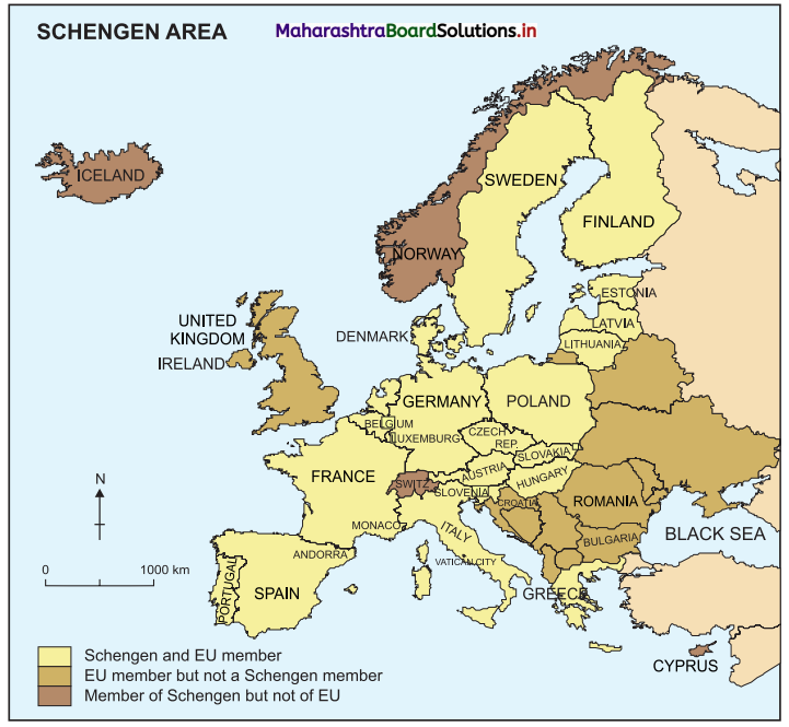
Maharashtra Board Class 12 Political Science Solutions Chapter 1 The World Since 1991 5
Question 1.
Name any four countries in the Schengen area.
Answer:
Sweden, Denmark, Germany, Belgium, France.

Maharashtra Board Class 12 Political Science Solutions Chapter 1 The World Since 1991

Question 2.
Name any two non-European Union countries within Schengen area.
Answer:
Norway, Romania, Bulgaria, Croatia.

3. State whether the following statements are true or false with reason.

Question 1.
SAARC is important for trade in South Asia.
Answer:
This statement is True.
(i) SAARC has eight member States from South Asia. It aims to accelerate economic growth and promote the welfare of the people of South Asia.
(ii) In 1993, South Asian Association for Preferential Trade Agreement (SAPTA) came into existence. It was replaced in 2006 by South Asian Association Free Trade Area (SAFTA). This helps in trade and economic activity in the region.

Question 2.
‘Maastricht’ Treaty was signed for the defence of Europe.
Answer:
This statement is False.
(i) On 7th February 1992, the Maastricht Treaty was signed to create the European Union.
(ii) This treaty led to the expansion of spheres of cooperation in internal affairs, foreign policies and defence policies.

Question 3.
The decade of 1980s is seen as the golden age of humanitarian intervention.
Answer:
This statement is False.
(i) The 1990s are seen as the ‘golden age of humanitarian intervention.’ In 1993, the World Conference on Human Rights was held in Vienna, which led to the creation of the office of UN High Commissioner for Human Rights.
(ii) Increasing awareness about human rights and their protection in international law gave rise to the phenomenon for protection of rights in the form of ‘humanitarian intervention’.

Maharashtra Board Class 12 Political Science Solutions Chapter 1 The World Since 1991
4. Express your opinion of the following.

Question 1.
Humanitarian intervention
Answer:
One of the main purposes of the UN is maintenance of international peace, security and cooperation. UN Peacekeeping Force comprises of military personnel and resources sent by member States. In the post-cold war era, the UN rationale for intervention was not just to stop ongoing wars but also to prevent reoccurrence of conflicts and protect the human rights of the affected people. The UN intervened in Cambodia, Somalia, Yugoslavia, East Timor, Eritrea, Syria, etc., for this purpose.

In 1993, over 170 nations participated in the World Conference on Human Rights, held in Vienna to reaffirm their commitment to protect human rights. The office of the UN High Commissioner for Human Rights was created to coordinate human rights initiatives. The increasing awareness about human rights protection in international law gave rise to humanitarian intervention especially in conflict zones. NGO’s have contributed significantly in the spread of humanitarian intervention for e.g. ICRC, Oxfam, etc. The 1990s are described as “golden age” of humanitarian intervention.

Maharashtra Board Class 12 Political Science Solutions Chapter 1 The World Since 1991

Question 2.
Regionalism in international politics.
Answer:
Countries which lie in geographical proximity create or join regional organisations which are based on common political, ideological, economic and infrastructural concerns. Some nations make special agreements regarding trade and economic cooperation. This is called a trade bloc.

(i) European Union (EU) was created in 1992 by Maastricht Treaty. It led to increased spheres of cooperation between European nations e.g. foreign affairs, defense, trade and creation of Euro as a common currency. Creation of Schengen Area is one of the achievements of the EU since the Schengen visa allows eligible individuals to travel freely within the 26 nations of the Schengen area.

(ii) ASEAN created in 1967 with headquarters at Jakarta comprises of 10 South-East Asian nations such as Brunei, Indonesia, Malaysia, Singapore, etc. It aims to promote political economic and security cooperation among it’s members.

(iii) SAARC formed in 1985 at Dhaka with 7 members. Today, it has 8 member countries of South Asia like India, Bhutan, Pakistan, etc. It aims to promote regional integration and economic development. It’s main achievement is the SAFTA.

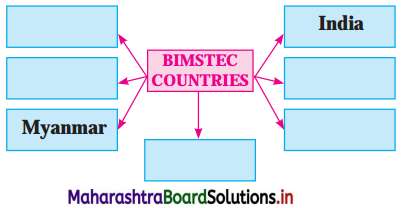
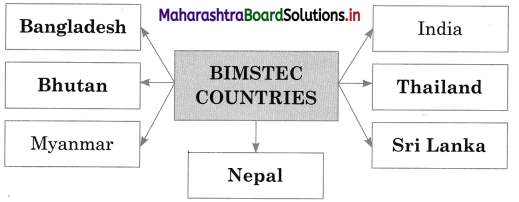
(iv) BIMSTEC – is a regional organisation founded in 1997 comprising of 7 member countries lying around Bay of Bengal for e.g. Bangladesh, India, Thailand, Myanmar. It aims to facilitate collaboration in economic, security and other concerns between member States.

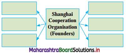
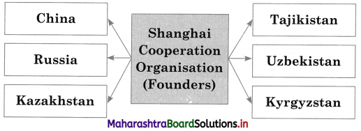
(v) Shanghai Cooperation Organisation (SCO) is an Eurasian political, economic and security organisation formed in 2001 with 6 member states. In 2016, India and Pakistan joined SCO. It’s focus is on maintaining peace and stability in the region, cooperation in trade, technology, etc.

Regional organisations play an important role in international politics. Due to this, unipolarity (US as the only superpower) ended leading to multipolarity.

5. Answer the Following.

Question 1.
Explain the term soft power with examples.
Answer:
According to American academic, Joseph Nye there are two types of power viz. hard power and soft power.
(i) Hard power is the ability to get others to act in ways that are contrary to their preferences and wills. It is the ability to coerce through threats and inducements for e.g.,Iraq invasion of Kuwait.

(ii) Soft power is when a country influences other countries without the use of military force. It is the ability to get others to want the outcomes that you want i.e. through attraction rather than coercion. Such influence is spread through economic, socio-cultural means.

Soft power was an important aspect of US domination. It implied the use of monetary aid, cooperative programmes, cultural exchanges, strong relations with allies. Examples of US soft power are cultural exports like fast food chains, movies, educational exchange programmes as well as disaster assistance programmes such as tsunami relief (Japan), flood control (Pakistan).

Maharashtra Board Class 12 Political Science Solutions Chapter 1 The World Since 1991
6. Answer the following question in detail with help of given points.

Question 1.
Discuss the European Union with help of given points.
(a) History
(b) European Commission
(c) European Parliament
(d) European Council
(e) European Court of Justice
Answer:
(a) History – The European Coal and Steel Community (ECSC) and European Economic Community (EEC) were created to foster economic interdependence. On 7th February 1992, the Maastricht Treaty was signed to create the European Union. This led to expansion of spheres of cooperation to include internal affairs, judicial matters, foreign policy, etc. The Euro (€) is the official currency of 19 out of 28 countries of the EU. These nations are collectively called ‘Eurozone’.

(b) European Commission – The Commission is the executive bureaucratic arm of the EU. It is mainly responsible for drawing up proposals for new European legislation,and it implements the policy decisions of the European Parliament and the Council of the EU.

(c) European Parliament – The European Parliament is composed of 751 Members, who are directly elected every five years. It is a body entrusted with legislative, supervisory, and budgetary responsibilities.

(d) European Council – The structure of the European Council consists of the Presidents or Prime Ministers of each member State, accompanied by their foreign ministers, and a full¬time President of the European Council. The European Council meets four times a year and provides strategic leadership for the EU.

(e) European Court of Justice (ECJ) – The ECJ interprets, and adjudicates on, EU law and treaties. As EU law has primacy over the national law of EU member States.

Maharashtra Board Class 12 Political Science Solutions Chapter 1 The World Since 1991

ACTIVITY

Find out the role played by India in BRICS (Text Book Page No. 13)
Answer:
BRICS refers to five major emerging national economies, i.e., Brazil, Russia, India, China and South Africa. It accounts for about 40% of the world’s population and 20% of the GDP. It is an emerging investment market and global power bloc. India serves a multi faceted role on the economic and political fronts.

(i) New Development Bank (NDB) was proposed by India during the BRICS summit in New Delhi. It was established in 2014 and intends to provide non conditional financing. India has contributed $ 10 billion to the NDB to refurbish industrial bases in Brazil and South Africa. There is a regional office of NDB in India.

(ii) In 2012, India introduced “security” on the agenda, as the theme of the summit in New Delhi was BRICS Partnership for Global Stability, Security and Prosperity.

(iii) India has also highlighted climate governance at BRICS meeting.

(iv) BRICS membership elevates India’s global profile for e.g., India has assumed the role of a trade facilitator in Africa and South Asia. It aims to promote intra-BRICS trade, which means urging member nations to import goods mainly from each other.

(v) India is seen as a strong voice at BRICS and the UN against proposals and actions that could harms any member’s interests for e.g., India turned down China’s proposal to invite Pakistan, Sri Lanka and Mexico into the BRICS to focus only on development within current members.

Class 12 Political Science Chapter 1 The World Since 1991 Intext Questions and Answers

ACTIVITY (Text Book Page No. 7)

Question 1.
What is One Belt One Road and China Pakistan Economic Corridor policy of China?
Answer:
One Belt One Road also called OBOR or Belt and Road Initiative (BRI) since 2016, is a global development strategy adopted by the Chinese government in 2013 involving infrastructure development and investments in nearly 70 countries in Asia, Europe and Africa. It is an ambitious economic development and commercial project that focuses on improving cooperation among multiple countries.

BRI involves building a network of roadways, railways, power grids, maritime ports, oil and gas pipelines and associated infrastructure projects. The project covers two parts i.e., Silk Road Economic Belt (land based) and expects to connect China with Central Asia, East and West Europe to connect China with Central Asia, East and West Europe) and 21st Century Maritime Silk Road (sea based and connects China to Africa, South East Asia, Mediterranean) BRI consists of six economic corridors such as China-Pakistan corridor, China- Indochina Peninsula corridor etc.

China-Pakistan Economic Corridor (CPEC) launched in 2015 is a part of the greater OBOR. It is a collection of infrastructure projects that are currently under construction throughout Pakistan for e.g., special economic zones, ports, energy projects, etc. The Gwadar Port (Balochistan province of Pakistan) which is considered the deepest seaport in the world is considered to be significant in the BRI. India has objected to the CPEC as upgrade works to the Karakoram Highway are taking place in Gilgit Baltistan (which is Indian territory) and will undermine India’s security and position in the region.

Maharashtra Board Class 12 Political Science Solutions Chapter 1 The World Since 1991

Question 2.
Who are the members of the European Union? (Text Book Page No.9)
Answer:
There are 27 countries who are members of European Union. These are Austria, Belgium, Bulgaria, Croatia, Cyprus, Czech Republic, Denmark, Estonia, Finland, France, Germany, Greece, Hungary, Ireland, Italy, Latvia, Lithuania, Luxembourg, Malta, Netherlands, Poland, Portugal, Romania, Slovakia, Slovenia, Spain, Sweden. UK was a member but left in January 2020.

The following countries are part of Eurozone.
Austria, Belgium, Cyprus, Estonia, Finland, France, Greece, Germany, Ireland, Italy, Latvia, Lithuania, Luxembourg, Malta, the Netherlands, Portugal, Slovakia, Slovenia and Spain. The Eurozone is the monetary union of 19 out of 27 countries of the EU i.e., those who have Euro (€) as their common currency. The other 8 EU countries continue to use their national currencies.

Maharashtra Board Class 12 Political Science Solutions Chapter 1 The World Since 1991

Question 3.
Discuss the case of Brexit. (Text Book Page No. 11)
Answer:
British Exit i.e., Brexit is the withdrawal of the United Kingdom from the European Union. In June 2016, 52% voted to leave the EU following a UK wide referendum. The UK finally left the EU on 31st January 2020.
The main reasons for Brexit were-
(i) EU threatens British sovereignty and prevents radical reforms.
(ii) The Euro has been a disaster and caused the Greek economic crisis.
(iii) UK could have a more rational immigration system outside the EU as the EU allows too many immigrants.

Brexit is a rejection of globalisation. The European Union signified a move from a single market to a single currency, a single banking system and eventually a single political entity. Many persons argue that Brexit goes against the concept of globalisation, i.e., it symbolizes a protest against the economic model that has been in place since 1992.

Many voters feel that globalisation has benefited only a small elite and hanker for a return to the security provided by the nation-States i.e., jobs, living standards, welfare facilities seemed better protected in the nation-States prior to globalisation for e.g., unemployment across the Eurozone is more than 10% and Italy, Greece, etc., are facing economic crisis.

Maharashtra State Board 12th Std Political Science Textbook Solutions

Global Climate Change Question Answer Class 11 Geography Chapter 5 Maharashtra Board

Std 11 Geography Chapter 5 Question Answer Global Climate Change Maharashtra Board

Balbharti Maharashtra State Board Class 11 Geography Solutions Chapter 5 Global Climate Change Textbook Exercise Questions and Answers.

Class 11 Geography Chapter 5 Global Climate Change Question Answer Maharashtra Board

Geography Class 11 Chapter 5 Question Answer Maharashtra Board

1. Complete the chain.

Question 1.

ABC
(1) Melting of snow(1) Increase in sea level(1) Flooding
(2) Effects of insolation(2) Erratic rains(2) Increase in frequency of cyclones
(3) Greenhouse gases(3) Methane(3) Agriculture
(4) Climate change(4) Average temperature of the earth(4) Existence of life on Earth

Answer:

ABC
(1) Melting of snow(1) Methane(1) Flooding
(2) Effects of insolation(2) Average temperature of the earth(2) Agriculture
(3) Greenhouse gases(3) Erratic rains(3) Existence of life on Earth
(4) Climate change(4) Increase in sea level(4) Increase in frequency on cyclones

Maharashtra Board Class 11 Geography Solutions Chapter 5 Global Climate Change

2. Identify the incorrect factor.

Question 1.
The causes of global warming-
(a) Emission of greenhouse gases
(b) Deforestation
(c) Apparent movement of the sun
(d) Industrialization
Answer:
(c) Apparent movement of the sun

Question 2.
The indicators of climate change-
(a) Retreat of glaciers
(b) Increase in the frequency of floods
(c) Increase in frequency of cyclones
(d) Increase in the minimum and maximum temperature
Answer:
(d) Increase in the minimum and maximum temperature

Question 3.
The tools for studying climate change
(a) Ice cores
(b) Coral reef
(c) Tree rings
(d) Ancient forts
Answer:
(d) Ancient forts

Question 4.
Measures to combat climate change –
(a) Banning the use of pesticides and insecticides
(b) Promoting afforestation and banning deforestation
(c) Banning public transport
(d) Banning fossil fuels
Answer:
(c) Banning public transport

3. Give geographical reasons.

Question 1.
It is important to study climate change.
Answer:
It is important to study climate change because –

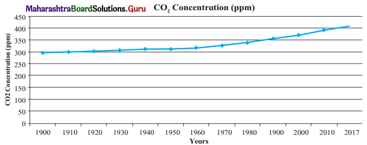
  1. The earth’s climate is changing faster primarily as a result of human activities.
  2. Number of flash floods are increasing, especially in urban areas.
  3. Due to warming of oceans the rate of evaporation is high, which is the root cause of both flooding and droughts.
  4. Due to increase in temperature, there is melting of snow on mountains and sea level is rising.
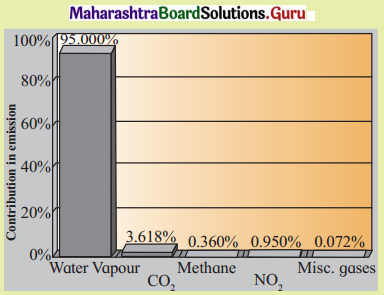
  5. Human activities, especially emissions of heat-trapping greenhouse gases from fossil fuel combustion, deforestation and land use changes are the primary drivers of the climate changes observed in the industrial era.

Maharashtra Board Class 11 Geography Solutions Chapter 5 Global Climate Change

Question 2.
There is a great possibility that we may not see Maldives on the world map in the future.
Answer:
There is a great possibility that we may not see Maldives on the world map in the future because-

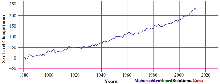
  1. Sea level continues to rise at a rate of about 3 mm/ per year, leaving no ground surface higher than 3 m.
  2. Due to global warming the rising of sea level is likely to worsen.
  3. Higher sea levels may lead to severe cyclones and periodic flooding of coastal areas.
  4. Since, Maldives is a flat country there is possibility that it may be submerged under sea water if the rise in sea level continues.

Question 3.
The snowline is retreating.
Answer:
The snowline is retreating because –

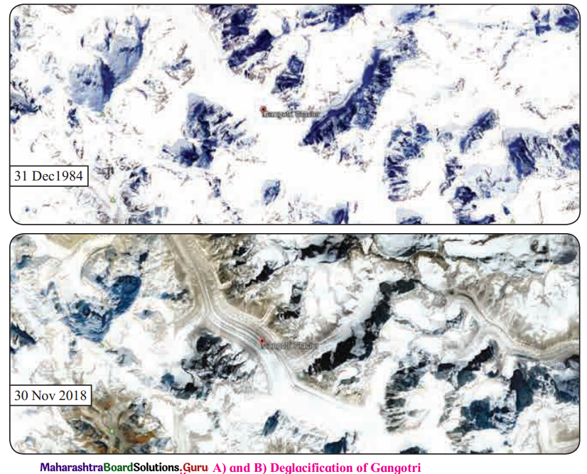
  1. A snowline is a boundary between a snow-covered and snow-free surface. Above the snowline there is permanent snow cover.
  2. When glaciers and icebergs melt at an alarming rate, it is a cause of concern. This is known as retreating glaciers.
  3. Due to changes in the climate there is less snowfall as compared to the previous years.
  4. This means that there is lesser ice formation each year than its rate of melting.
  5. Thus, due to melting of glaciers and icebergs as well as less snowfall the snowline is retreating.

Question 4.
There is an increase in the frequency of droughts and cyclones.
Answer:
There is an increase in the frequency of droughts and cyclones because-

  1. In addition to triggering more rainfall, global warming could also increase the occurrence of drought.
  2. The roots of both flooding and drought lie in the physical process known as evaporation.
  3. As global warming heats the world’s oceans, the water molecules near the sea surface become more energetic and tend to evaporate into the atmosphere more readily. Thus, water vapour is formed.
  4. Similarly, due to global warming, the number of cyclones in a year and their intensities have also increased in the tropical regions.

4. Write short notes on.

Question 1.
Bleaching of coral reefs
Answer:

  1. When temperature changes, corals throw out the algae living in their tissues.
  2. These algae are responsible for their colour.
  3. An increase of 1°C – 2°C in ocean temperatures for a long time can lead to bleaching, turning corals white.
  4. If corals are bleached for prolonged periods, they eventually die.
  5. Coral bleaching leads to death of large amounts of corals.

Maharashtra Board Class 11 Geography Solutions Chapter 5 Global Climate Change

Question 2.
Flash floods
Answer:

  1. A flash flood is a term that describes floods, which is usually observed in the low-lying areas.
  2. Floods are caused due to extremely heavy rainfall.
  3. Flash floods generally occur after the collapse of natural ice, debris dam or a man-made dam, etc.
  4. Flash foods also occur due to very high precipitation in one day (Mumbai in 2005, Kedarnath in 2013) or because of changed weather conditions like cyclones (Chennai, 2015).
  5. Flash foods are different from the regular floods by having a time scale of fewer than six hours between rainfall and the onset of flooding.

Question 3.
Tools to study Paleoclimatology
Answer:
Paleoclimatology is the study of the weather and climate of the earth’s past. Scientists and meteorologists have been using instruments to measure climate and weather for the past 140 years. However, millions of years ago historical evidence called proxy data, which includes coral reefs, tree rings, ice cores, etc., were used to tell about the climate.

Coral reefs:

  1. Coral reefs are very sensitive to changes in climate. –
  2. Corals form skeletons by extracting calcium carbonate from the ocean waters.
  3. When the water temperature changes, densities of calcium carbonate in the skeletons also change.
  4. Coral formed in the summer has a different density than coral formed in the winter.
  5. This creates seasonal growth rings on the corals.
  6. Scientists can study these rings to determine the temperature of the water and the season in which the coral grew.

Tree rings:

  1. There are rings on the stem of the tree.
  2. Variation in these rings is due to variation in the environmental conditions when they were formed.
  3. Thus, studying this variation leads to improved understanding of past environmental conditions.

Ice cores:

  1. These are samples of ice taken from the inner sides of the ice sheets.
  2. Throughout each year, layers of snow fall over the ice sheets in Greenland and Antarctica.
  3. Each layer of snow is different.
  4. Summer snow differs from winter snow.
  5. Each layer gives scientists a lot of information about the climate each year.

Question 4.
Greenhouse gases
Answer:

  1. Greenhouse gases are the primary gases, such as, water vapour carbon dioxide, nitrous oxide, methane and ozone in the earth’s atmosphere that absorbs and traps energy from the sun.
  2. Of all greenhouse gases, carbon dioxide absorbs more heat.
  3. Without greenhouse gases, the average temperature of the earth’s surface would be about -18°C rather than the present average of 14°C.
  4. Carbon dioxide emissions comes from many human activities such as combustion of fossil fuels, oil and natural gas, with additional contributions coming from deforestation, changes in land use, soil erosion and agriculture (including live stock).

Maharashtra Board Class 11 Geography Solutions Chapter 5 Global Climate Change

5. Answer in detail.

Question 1.
Climate change has not always been anthropogenic in nature. Explain.
Answer:
Though the human activities are a major cause behind climate change, there are some natural causes for climate change. They are as follows:
Amount of energy output by the sun:

  1. Low energy output by the sun can reduce amount of insolation received by the earth.
  2. This can lead to cooling of the earth.

Milankovitch Oscillation:

  1. The earth’s rotation around its own axis and revolution around the sun is responsible for the changes in climate.
  2. Their changes alter the amount of insolation received from the sun, which in turn might affect its climate.
  3. It can cause the earth to be closer to the sun (warmer) and farther from the sun (colder).
  4. The ice ages can occur when we are farther from the sun.

Volcanism:

  1. Volcanic eruptions throw lots of particulates and aerosols into the atmosphere.
  2. These aerosols remain in the atmosphere for a considerable period of time.
  3. The winds spread it around the world, thus reducing the sun’s radiation reaching the earth’s surface.

Goldilocks Zone:

  1. The earth lies in the habitable zone called the Goldilocks Zone.
  2. Earth experiences cooler climate, when it was located in the outer reaches of this zone.
  3. As the size of the sun increases the zone moves outward over time.
  4. Such changes in the zone causes earth to warm or cool.

Maharashtra Board Class 11 Geography Solutions Chapter 5 Global Climate Change

Question 2.
What measures will you suggest to combat climate change in your village/city.
Answer:
Following measures can be taken to combat climate change in our village / city.

  1. Afforestation should be encouraged in and around play areas, hill sides, schools, etc.
  2. Deforestation should be avoided strictly.
  3. The use of public transport should be enabled to lessen the vehicular pollution. Thus, emission of harmful gases such as CO2, etc., can be prevented.
  4. Use of natural manure can be encouraged instead of using fertilizers.
  5. In villages, Liquefied Petroleum Gas (LPG) should be used instead of using coal or wood as fuel.

11th Geography Digest Chapter 5 Global Climate Change Intext Questions and Answers

Can you tell? (Textbook Page No. 58)

1. The graph in the figure shows the difference between the global average temperature of the twentieth century and global monthly temperatures from 1985 to 2015. Answer the questions given below.
Maharashtra Board Class 11 Geography Solutions Chapter 5 Global Climate Change 1

Question 1.
In which year is the difference the least?
Ans.
Difference in the temperature is least in the year 1985.

Question 2.
What is the difference between the mean temperatures of the twentieth century and temperature in 2015?
Answer:
The difference between the mean temperature of twentieth century (1995-2000) and 2015 is 0.8°C.

Question 3.
Why do the temperatures differ in different months?
Answer:
The temperature differs in different months because of the occurrence of different seasons.

Maharashtra Board Class 11 Geography Solutions Chapter 5 Global Climate Change

2. Look at the graph and answer the questions. (Textbook Page No. 63)
Maharashtra Board Class 11 Geography Solutions Chapter 5 Global Climate Change 2

Question 1.
What does this graph show?
Ans.
The graph shows CO2 concentration (ppm) and its increased level over the period of time from 1900 to 2017.

Question 2.
What does ppm mean?
Answer:
The abbreviation ppm means ‘parts per million’ of carbon concentration in the atmosphere.

Question 3.
Since which year has the increase been phenomenal?
Answer:
After 1980, there has been a phenomenal increase observed.

Question 4.
Can you think of the reasons behind the increase in carbon dioxide?
Answer:
The reasons behind the increase in carbon dioxide is due to combustion of fossil fuels and large- scale deforestation.

Try this. (Textbook Page No. 59)

1. Look at the following graph. Answer the following question.
Maharashtra Board Class 11 Geography Solutions Chapter 5 Global Climate Change 3

Question 1.
Which of these gases has the highest contribution?
Answer:
Water vapour, shows the highest contribution.

Maharashtra Board Class 11 Geography Solutions Chapter 5 Global Climate Change

Question 2.
Which of these gases came from natural and man-made sources?
Answer:
Water vapour, methane, NO2 and miscellaneous gases are naturally occurring gases while CO2 is man-made.

Question 3.
Which activities are responsible for their emission?
Answer:
Burning of fossil fuels like coal, etc., and deforestation are responsible for emission of CO2.

Question 4.
Out of these, whose emission can be controlled by humans?
Ans.
The emission of CO2 can be controlled by humans.

Question 2.
Make a list of things you need to change in your lifestyle. (Textbook Page No. 67)
Answer:

  1. Use of public transport.
  2. Less use of wood but more use of alternatives to wood.
  3. Regular maintenance of vehicles.
  4. Avoid wastage of water.
  5. Use of energy efficient devices.
  6. Ban on plastic goods.
  7. Minimum use of paper in home and office.
  8. Purchase of only required goods.
  9. Use of Eco-friendly goods.
  10. Celebration of festivals without harming the environment.

Find out! (Textbook Page No. 62)

Question 1.
Use internet and reference books on climate change and make a list of species vulnerable to climate change.
Answer:
Species vulnerable to climate change are: corals, polar bear and frogs.

Maharashtra Board Class 11 Geography Solutions Chapter 5 Global Climate Change

Question 2.
Make a list of movies based on ice age and climate change. (Textbook Page No. 65)
Answer:

  1. Interstellar
  2. Beasts of the Southern Wild
  3. Chasing Coral
  4. Snowpiercer
  5. An Inconvenient Truth
  6. Are you ready to fight? (Vattaram)

Question 3.
With the help of internet, find out the details of the National Action Plan on Climate Change (NAPCC), 2008 and its missions. (Textbook Page No. 66)
Answer:
NAPCC is a government document that includes eight ambitious goals set for the country to achieve.

  1. National Solar Mission
  2. National Mission for Enhanced Energy Efficiency
  3. National Mission on Sustainable Habitat
  4. National Water Mission
  5. National Mission for Sustaining the Himalayan Ecosystem
  6. National Mission for a “Green India”
  7. National Mission for Sustainable Agriculture
  8. National Mission on Strategic Knowledge for Climate Change

1. Look at the graph and answer the following questions. (Textbook Page No. 60)

Maharashtra Board Class 11 Geography Solutions Chapter 5 Global Climate Change 4
Question 1.
What does the graph show?
Answer:
The graph shows an increase in the global sea level from 1880 till date.

Question 2.
In which year is the change around 225 mm?
Answer:
The change around 225 mm is observed is the year 2018.

Question 3.
What conclusions can you draw by seeing the graph?
Answer:
With the continued global warming the sea levels are likely to rise.

Maharashtra Board Class 11 Geography Solutions Chapter 5 Global Climate Change

Question 4.
What correlation can be seen in this graph and the graph of rising temperature?
Answer:
With the rising temperature the sea level is rising. We can conclude this from both the graphs.

Question 2.
Compare both the satellite images in fig 5.3 (A) and (B). (Textbook Page No. 61)
Maharashtra Board Class 11 Geography Solutions Chapter 5 Global Climate Change 5
Answer:
Fig. 5.3 (A) shows the snow-covered Gangotri glacier area in Dec. 1984, whereas in Fig. 5.3 (B) the snow-covered region of the Gangotri glacier has retreated by 2018.

Maharashtra State Board Class 11 Geography Textbook Solutions

Climatic Regions Question Answer Class 11 Geography Chapter 4 Maharashtra Board

Std 11 Geography Chapter 4 Question Answer Climatic Regions Maharashtra Board

Balbharti Maharashtra State Board Class 11 Geography Solutions Chapter 4 Climatic Regions Textbook Exercise Questions and Answers.

Class 11 Geography Chapter 4 Climatic Regions Question Answer Maharashtra Board

Geography Class 11 Chapter 4 Question Answer Maharashtra Board

1. Write the names of climatic regions according to the factors that dominate their characteristics.

Maharashtra Board Class 11 Geography Solutions Chapter 4 Climatic Regions 1
Answer:
Maharashtra Board Class 11 Geography Solutions Chapter 4 Climatic Regions 2

Maharashtra Board Class 11 Geography Solutions Chapter 4 Climatic Regions

2. Choose the correct alternative

Question 1.
Monsoon region
(a) annual average temperature around 27° C
>2500 mm annual precipitation
Indonesia
Hard-wood evergreen trees

(b) Average temperature in Summers around 35° C
< 2500 mm annual rainfall
South East Asia
Hard wood deciduous trees

(c) Temperatures in summer around 35° C
1000 mm annual rainfall
Continental part of Indian peninsula
Tall and thick grass

(d) Average temperatures in summer around 27° C
1000 mm rainfall in winter
South Africa
Hard–wooded, waxy, evergreen forests
Answer:
(b) Average temperature in Summers around 35° C
< 2500 mm annual rainfall
South East Asia
Hard wood deciduous trees

Maharashtra Board Class 11 Geography Solutions Chapter 4 Climatic Regions

Question 2.
The region with high diurnal range of temperature
(a) Tropical rainforests
(b) Tropical grasslands
(c) Tropical desert regions
(d) Tropical Monsoon regions
Answer:
(c) Tropical desert regions

Question 3.
Lumbering flourished as an occupation from Newfoundland to Alaska in North America because
(a) Tundra Climatic Region
(b) Taiga Climatic Region
(c) West European Climatic Region
(d) China-type climatic region
Answer:
(b) Taiga Climatic Region

Question 4.
The main reason behind the months of precipitation in the graphs of Monsoon climatic regions being different is
(a) ITCZ
(b) orographic rainfall
(c) hemispheres are different
(d) apparent movement of the sun
Answer:
(a) ITCZ

3. Give geographical reasons.

Question 1.
In monsoon climate region, rainfall occurs in specific season.
Answer:
In monsoon climate region, rainfall occurs in specific season because-

  1. The differential heating and cooling of land and water creates low pressure on the land while the sea experiences high pressure.
  2. This is strongly related to shifting of the ITCZ. During the summer the ITCZ moves north to the latitudes of 20°-25°.
  3. Several months later, the moisture laden summer monsoon is replaced by dry north-east monsoon.
  4. By this time, the ITCZ has shifted to the southern hemisphere.
  5. In northern hemisphere, the winds move from sea to land bringing moisture along with them in summers and gives rainfall.
  6. In southern hemisphere same conditions prevail when there are winters in the northern hemisphere.

Maharashtra Board Class 11 Geography Solutions Chapter 4 Climatic Regions

Question 2.
Taiga region is not found in Southern Hemisphere.
Answer:
Taiga region is not found in Southern Hemisphere because-

  1. There is not much land at higher altitude in the southern hemisphere (until inside the Antarctic circle) where it is permanently ice covered.
  2. Most of the land is fairly close to oceans and thus tempered by marine warming.
  3. Whereas, Taiga is found throughout the high Northern latitudes between Tundra and the temperate forest, characterised by coniferous forests.
  4. The strong oceanic influence in the southern hemisphere reduces the severity of the winter, thus, affecting the temperature and precipitation.

Question 3.
The diurnal range of temperature is more in desert areas.
Answer:
The diurnal range of temperature is more in desert areas because-

  1. Deserts get hot during the day, but cool down rapidly during night. The main reasons for the temperature fluctuation between day and night are the lack of humidity and cloud cover.
  2. Because of water’s relatively high specific heat, humid air takes longer to warm or cool, while air on land warms or cools more quickly.
  3. Because desert areas receive a large amount of sunlight, the temperatures can get very high, but during night the dry air cools quickly.
  4. The lack of cloud cover overhead allows the warmer air to rise into the atmosphere while cooler air settles in its place.
  5. Basically, desert temperature varies so much because there is less moisture and cloud to keep the heat there.

Question 4.
There is no concept of season in equatorial regions.
Answer:
There is no concept of season in equatorial regions because-

  1. The equatorial region lies between 0° to 10° latitudes in both the hemispheres.
  2. The sun is exactly overhead in the equatorial regions throughout the year giving maximum insolation.
  3. Thus, constant high temperatures are experienced throughout the year, which gives rise to heavy convectional precipitation.
  4. Days and nights are almost of equal length and thus, the concept of summer and winter as being hot and cold seasons do not exist in these parts.

Question 5.
The Savannah region is prone to droughts.
Answer:
The Savannah region is prone to droughts because-

  1. The region lies between 10° to 20° N and S latitudes, where the sun’s rays at noon are never far from overhead and thus the insolation is maximum and temperature is constantly high here.
  2. Distinct wet and dry seasons of relatively equal duration are found. Most of the regions annual rainfall is experienced during the wet season and very little precipitation falls during the dry season.
  3. A lengthy dry season and a relatively short wet season is the characteristic of Savannah region.
  4. Thus, in Savannah region the dry season becomes more severe and often drought conditions prevail during the course of the year.

Maharashtra Board Class 11 Geography Solutions Chapter 4 Climatic Regions

Question 6.
Though Mussoorie and Dehradun are located on the same latitude, why is their climate different?
Answer:
Though Mussoorie and Dehradun are located on the same latitude, their climate is different because-

  1. Dehradun lies in the humid sub-tropical climatic region where the summers are long, hot and humid. Whereas, Mussoorie is a hill station in Dehradun district of Uttarakhand which lies in sub-tropical climatic regions that are very wet.
  2. Dehradun lies at an elevation of average 450 m above mean sea level whereas Mussoorie is at an elevations of 1880 m above mean sea level.
  3. In Dehradun during monsoon season there is often heavy and protracted rainfall, whereas in Mussoorie an average of 660 mm orographic rainfall is experienced.
  4. The winter temperature is around 1°C and 20°C in Dehradun with fog commonly experienced. Mussoorie usually receives few spells of snowfall in December, January and February.

4. Differentiate between.

Question 1.
Equatorial Rainforests and Savannah Climatic Regions.
Answer:

Equatorial RainforestsSavannah Climatic Regions
Latitudinal extentIt lies between 0° to 10° latitudes in both the hemispheres.It lies between 10° to 20° latitudes N and S.
TemperatureAs it lies near the equators sun rays are perpendicular and hence temperature is constantly high with average temperature around 27°C.Distinct wet summers and dry winters with summer temperatures around 35°C and winter temperature around 24°C.
RainfallHeavy convectional rainfall of 2500 mm to 3000 mm is evenly distributed over the year.In this region average rainfall of 250 mm to 1000 mm is expected.
VegetationEvergreen trees with dense three layered vegetation are found in rainforests.Tall thick grass (Elephant grass) with scattered drought-resistant trees are found in this region.
AnimalsClimbing and jumping animals, reptiles, etc., are found in this region.Grazing of animals is common. Herbivorous, carnivorous and scavengers are found in this region.
Regions of the worldThis type of climate is found in the Amazon basin, Congo basin, east coast of Central America, Madagascar, Malaysia, Indonesia, Philippines and Papua New Guinea.This type of climate is found in India in peninsular plateau and rain-shadow zone in Maharashtra, Telangana and Karnataka; parts of Mizoram. It is also found along borders of Congo, South Central Africa, llanos of Venezuela, Campos of Brazil, etc.

Question 2.
Taiga Region and Tundra Region.
Answer:

Taiga RegionTundra Region
Latitudinal extentTaiga region is found between 55° to 65° North latitude.Tundra region is found between 65° to 90° North latitude.
Temperature (Summer)Brief cool summers with temperature around 15°C to 20° C.Summer temperature is aroundl0°C.
Temperature (Winter)Bitterly cold winters with temperature less than 0°C is found in this region.Winter temperature is around -20°C to -30°C.
PrecipitationYear-round precipitation is around 300 to 500 mm in summers, snowfall in winters.Precipitation is in form of snow around 300 to 500 mm.
Other

Atmospheric phenomenon

Heavy cloud cover, high humidity, drizzle, fog, frost, cold winter poleward are the characteristics of Taiga region.Low evaporation, coastal fog are the characteristics of Tundra region.
LocationContinental location.Proximity to coasts.
VegetationConiferous forest with soft wood, vegetables and root crops are found.Tundra vegetation, swamps during melting is formed.
Animal lifeAnimals with fur like moose, foxes, bear, etc., are found.Animals with fur like polar bear, seal, walrus are found.
Human occupationHunting and lumbering is the major occupation.Hunting and fishing is the major occupation.
Regions of the worldNorthern part of North America from Newfoundland to Alaska, northern Eurasia from Scandinavia through most of Siberia to the Bering Sea and Sea of Okhotsk are the major regions where Taiga region is found.Arctic ocean borderlands of North America, Greenland and Eurasia, Antarctic, Peninsula, some polar islands are the major regions under Tundra vegetation.

Maharashtra Board Class 11 Geography Solutions Chapter 4 Climatic Regions

Question 3.
Monsoon and Mediterranean Regions.
Answer:

Monsoon RegionMediterranean Region
Latitudinal extentWithin 10° to 30° North and South of equator.Western coastal region between 30° to 40° North and South.
TemperatureSummer temperature is around 27°C to 32°C while winter temperature is 15°C to 24°C. High annual range of temperature.Summers are warm and dry and temperature is around 21°C to 27°C while winters are mild and moist and temperature is around 10°C to 14°C.
RainfallRainfall is between 250 to 2500 mm, excessively wet during rainy season.Rainfall is around 500 to 1000 mm in winter.
VegetationTropical rainforest, ranges from jungle to thorn forest in drier boundaries.Scrub, forests have leaves evergreen, hard, thick leathery and small. Coniferous vegetation on higher altitudes and grass in areas of low rainfall is found. Winter- sown grains, olives, grapes, vegetables, citrus fruits are found.
Human LifeAgriculture is the main occupation of people of monsoon region.Development of tourism and cinema industry.
Regions of the worldCoastal areas of South West India and South East Asia, South West Africa, North East and South East Brazil, Northern part of Australia and parts of Japan come under the monsoon winds.Central California, borders of Mediterranean Sea, Cape Town (South Africa), Southern and South West Australia, Central part of Chile are the major region under Mediterranean climate.

5. Answer in detail.

Question 1.
Explain, with examples, the effects of latitude on a place’s climate.
Answer:
Latitudes affect the climate of a place in different ways-
Places close to the equator receive more sunlight:

  1. The equatorial region lying between 0° to 5° North and South latitudes receive maximum heat as the sunrays are directly falling on the equator.
  2. Due to which the region receives heavy rainfall throughout the year.
  3. As a result, evergreen forests are found is such regions.
  4. Example : Amazon basin.

Places close to the tropical region receives less sunlight:

  1. Temperature gradually decreases with increasing distance from the equator, as the angle of sun’s rays decreases from it.
  2. In tropical areas the sun rays become slanting and thus it gives less heat but covers more area.
  3. Example regions lying between Tropic of Cancer 231/2°N to Tropic of Capricorn 23/4°S. Similarly, in the temperate regions 66X/20N and S and the polar regions the climate become extremely cool as the intensity of heat decreases. These regions are thus covered by snow.

Question 2.
Explain with examples, how winds affect the climate of a place.
Answer:

  1. The winds affect the climate because they create the hot and cold air which moves around.
  2. Prevailing winds affect the climate of an area. The direction of local winds is determined by the daily temperature of variations.
  3. When winds blow from warm areas, they carry higher temperatures while winds blowing from cold areas carry lower temperatures.
  4. Thus, winds bring in heat/ cold from the direction it has been blown from and thus changes the temperature of the place which affects the climate. For e.g., cold wind waves from the Himalayas carry coldness to the parts of the Deccan plateau.
  5. Winds that blow from the sea often carry moisture and give rain to the coast. For e.g.. south-west monsoon winds give heavy rainfall in the western coastline of India.
  6. Some winds are warm and dry, they increase the temperature during winter season. For example, winds that blow to Britain from warm areas such as Africa are warm and dry. Such warm and dry winds increase the summer temperature in some areas.

Maharashtra Board Class 11 Geography Solutions Chapter 4 Climatic Regions

Question 3.
Russia is larger than Chile in area but does not experience climatic diversity as Chile. Explain.
Answer:

  1. The latitude and longitude of Russia is 61.5240°N and 105.3188°E respectively. It is located in northern Asia, between Europe on one side and North Pacific Ocean on the other side.
  2. Chile is situated along western margin of South American continent. Its latitude and longitude are 35.6751°S and 71.5430°W respectively.
  3. Russia has continental location since it is surrounded to south and west by huge landmass, and to the north lies Arctic ocean which is frozen, so it is like snow covered land.
  4. Thus, due to continental location there are dry summer and very cold winters with temperatures of -30° and less and sometimes heavy snowfall.
  5. The winter is mostly dry, snow covers the ground from the end of October to mid-March.
  6. In Chile the coastal location and the east-west extent is very less.
  7. There is a lot of climatic diversity in Chile. There is Atacama Desert in the north, Mediterranean climate at the central part, extreme cold climate in the east.
  8. The most important factors that control the climate of Chile are Pacific anticyclone, cold Humboldt ocean current and mountain ranges along the coastline.
  9. Thus, though Russia is larger than Chile in area but does not experience climatic diversity as Chile.

Question 4.
Explain the factors affecting climate of a place giving examples.
Answer:
Maharashtra Board Class 11 Geography Solutions Chapter 4 Climatic Regions 3
Latitude : Latitude is the primary factor influencing distribution of atmospheric temperature. Generally, latitudes of high degrees are less warm than the low degrees of latitudes. Thus, sun’s rays making a high angle to the ground, experience high temperature throughout the year. Temperature gradually decreases with increasing distance from the equator as the angle of the sun’s rays decreases away from it. Hence, the polar region experiences very low temperature.

Altitude : The atmosphere is indirectly heated by terrestrial radiation from surface of the earth. Therefore, the place near the sea level experiences higher temperature than the places situated at higher altitude. In other words, the temperature generally decreases with increase in height. The rate of decrease of temperature with increase in height is known as Normal Lapse rate. It is 6.4°C per 1000 meters altitude.

Distance from the Sea : The location of place with respect to the sea also determines the temperature of that place. Though, the sun provides same amount of heat over land and water bodies, there is difference in their heating and cooling capacity. Compared to land, the sea (water) gets heated slowly and loses heat slowly. On the other hand, land heats up and cools down faster. Therefore, the variation in temperature over the water bodies is less as compared to land masses. The coastal areas come under the moderating influence of the sea and land breezes and experience moderate or equable climate while interior parts of the continents experience extreme climate.

Prevailing winds : Winds affect the temperature and rainfall of any area. Winds carry with them the temperature of their source regions. Hot winds increase the temperature while cold winds decrease the temperature, e.g., cold wind waves from Himalayas carry low temperature to parts of the Deccan Plateau. Thus, south west monsoon winds in India reduce the temperature after the onset of monsoon in June all over the country.

Some winds carry moisture and give rain to the area they visit. For example, South-west monsoon winds give rainfall to western coastline of India.

Ocean currents : Ocean currents considerably influence temperature of the adjacent land area. Warm currents raise the temperature of the coastal areas, whereas cold currents reduce the temperature near the coast where they flow.

Aspect of slope : In the northern hemisphere the south facing slopes and in the southern hemisphere the north facing slopes always face the sun. Hence, sun facing slopes are warmer and the opposite slopes are cooler.

6. On a world map, show the following areas

(1) Equatorial Rainforests and Savannah Climatic Regions.
(1) Savannah climatic region in Africa
(2) Highland climatic region in India
(3) Chile and Russia
(4) Ice cap climatic region
(5) Desert
Answer:
Maharashtra Board Class 11 Geography Solutions Chapter 4 Climatic Regions 4

Maharashtra Board Class 11 Geography Solutions Chapter 4 Climatic Regions

11th Geography Digest Chapter 4 Climatic Regions Intext Questions and Answers

Use vour brain power!

Question 1.
(i) Have you ever thought why there is difference in the skin colour of various people in the world?
(ii) Why all the people in the world do not eat same food?
(iii) Why there is a variety in clothing pattern and types too? Even our houses are different.
(iv) How come flora and fauna are restricted to a particular region?
(v) Why different fruits are found in different places? (Textbook Page No. 44)
Answer:
(i) There is variation in skin colour of people depending on the latitudes. For. e.g., people near the equator are dark since the sunrays are vertical and hence there is too much heat, while people in temperate or polar region are fair since sunrays in these regions are slanting due to increase in distance from sun. Hence, there is low temperature and colour of skin is fair.

(ii) There is variation in food because food depends on geographical factors like climate, soil, location etc. For example, in extreme cold climate areas soil is covered with snow, so agriculture is not possible, people eat fish and meat of fur bearing animals. The countries located along the coastline eat fish and rice because fishing is carried out at the coastal areas and rice is grown on fertile delta of the river along the coastline.

(iii) People prefer to use clothes according to climate. For example, Inuits in Polar region wear fur clothes due to extreme cold climate, Europeans wear woollen cloths in winter due to cold climate, Asians mostly wear cotton clothes except in winter.

The pattern of house depends upon the climate and availability of material in the surrounding area. For example, in heavy rainfall areas houses have sloping roofs, in hot climatic areas houses are made up of stones or thick walls to prevent the effect of outside hot air.

People use material available in the surrounding area for construction of houses. For example, Inuits in Polar region use snow to build houses, since it is available in plenty. These peculiar houses are called Igloos.

(iv) Particular temperature and rainfall are essential for the growth of flora. For example, coniferous forest grows in cool climate and snowfall. Flora provides food and shelter to fauna, therefore wherever there is thick flora, fauna is bound to be there. In grassland region grass eating animals like dear, antelope, rabbits are seen but the camel is seen only in the desert.

(v) Every fruit crop requires particular type of climate; therefore, different fruits grow in different areas depending upon the climate. For example, apples are grown in Jammu and Kashmir, mangoes, cashew nuts and jackfruits are grown in the Konkan region due to suitable climate.

Question 2.
(i) What would be the annual range of temperature in this region?
(ii) Where is this type of climate found in India? (Textbook Page No. 46)
Answer:
(i) In equatorial region both diurnal and annual range of temperature will be low as it experiences high temperature all year round. The annual range of temperature may be as low as 3°C.

(ii) This type of tropical rainforest climate is found in north eastern states of India, western coast of West Bengal, and Andaman and Nicobar Islands.

Question 3.
Comment upon the type of weathering which will occur in this region. (Textbook Page No. 47)
Answer:
Mechanical and chemical weathering is predominant in this region.

Maharashtra Board Class 11 Geography Solutions Chapter 4 Climatic Regions

Question 4.
(i) Which agricultural crops are produced here?
(ii) Why are longitudes not given in geographical distribution? (Textbook Page No. 48)
Answer:
(i) Maize and rice are grown all over Savannah region. Sorghum and millets are grown in northern Savannah. Stray crops and vegetables are grown in all regions.

(ii) Temperature is the main element of climate. The temperature varies with latitude and not with longitudes. Geographical distribution is the natural arrangement of the various forms of plants and animals in different regions and localities of the earth. This distribution varies with the latitude as we go away from the equator towards the poles. Thus, longitudes are not given.

Question 5.
Comment upon the rate of weathering in this climate. (Textbook Page No. 49)
Answer:
Mechanical or physical weathering is predominant in arid regions. The rate of weathering is very slow in this region.

Question 6.
Why do people in Europe use olive oil for cooking? (Textbook Page No. 50)
Answer:
Most olives are grown in the southern part and is used for almost every application. It is a healthy type of oil which makes it great for cooking.

Question 7.
What factors make this region agriculturally productive? [Textbook Page No. 51]
Answer:
Year-round precipitation and fertile soil along the rivers make the region agriculturally productive.

Question 8.
(i) Why does Chile recur frequently in examples of geographical distribution?
(ii) Why has fishing developed here? (Textbook Page No. 52)
Answer:
(i) The geography of Chile is extremely diverse as the country extends from a latitude 17° South to Cape Horn at 56° and ocean on the west to Andes on the east. It borders Pacific Ocean towards south and small part of the south is towards the Atlantic Ocean.

(ii) Due to long indented coastlines and cool climate, fishing is done on a large scale. Presence of South Pacific Ocean and small part of South Atlantic Ocean are major fishing regions.

Question 9.
(i) What would be the annual range of temperature in this climate? What could be the occupational activities carried out by humans here?
(ii) What type of weathering will be prominent here? (Textbook Page No. 53)
Answer:
(i) The annual range of temperature in Taiga is 60°, the summer temperature can be 10°C and average winter temperature is -60°C. Hunting and lumbering can be carried out in this region.

(ii) Since the region is covered by snow weathering is slow. Mechanical weathering is prominent here but is very slow. Alternate freezing and thawing takes place here.

Maharashtra Board Class 11 Geography Solutions Chapter 4 Climatic Regions

Question 10.
What kinds of mass movement may happen here? [Textbook Page No. 54]
Answer:
Slow mass movement takes place here in the form of slumping where snow particles moves short distance down the slope.

Question 11.
(i) What kind of activities will bring people from other regions to this climate?
(ii) What could be the occupations followed here? (Textbook Page No. 55)
Answer:
(i) Since this region is severely covered by snow, scientific research and exploration can be done or fishing and hunting can be done but on a very smaller scale.

(ii) Hunting of aquatic life is the dominant occupation followed here.

Question 12.
(i) What type of human activities will develop in this region?
(ii) In what ways might high latitudes be different from high altitudes? (Textbook Page No. 56)
Answer:
(i) Terrace farming, animal rearing and tourism are the types of human activities that might develop in this region.

(ii) High latitudes are the regions away from the equator. The intensity of sunlight goes on decreasing as we move away from the equator towards the poles. The equatorial and tropical regions will have precipitation in the form of rainfall.

High altitude regions are the regions at an elevation from the mean sea level. In high altitude regions temperature decreases with increase in height therefore they are covered by snow as precipitation is in the form of snowfall.

Can you tell?

Question 1.
Make a list of the human activities you think that are not influenced by climatic elements. (Textbook Page No. 44)
Answer:
There are five major activities of man.
Primary: Agriculture, fishing, lumbering, hunting and gathering.
Secondary: Industries and manufacturing.
Tertiary: Services like transport and communication, teachers, doctors, etc.
Quaternary: Research and development etc.
Quinary: Highly intelligent activities.

2. Read the graphs and answer the following questions. (Textbook Page No. 46)
Maharashtra Board Class 11 Geography Solutions Chapter 4 Climatic Regions 5

Question 1.
In which months there is no rainfall?
Answer:
In both Belem and Singapore it rains throughout the year.

Question 2.
In which month is the temperature highest?
Answer:
The temperatures is highest in the month of October in Belem and in the month of May in Singapore.

Question 3.
In which month is the temperature lowest?
Answer:
The temperature is lowest in the months of January and February in Belem and in the month of December and January in Singapore.

Question 4.
What could be the factors which influence the climate of these places?
Answer:
Both Belem and Singapore lie in the equatorial region, i.e., at 1° 27′ S to 48° 30′ W and 1° 17′ N and 103° 51′ E respectively. Thus, in both Belem and Singapore, the climate is characterised by uniform temperature and pressure, high humidity and abundant rainfall as the sunrays are perpendicular on the equator throughout the year.

Question 5.
Write a concluding statement about the climate of both the places based on the questions above.
Answer:
Both cities experiences rainfall throughout the year. These is no dry season month. Average temperature varies little throughout. There is no distinct season, uniform temperature, high humidity and abundant rainfall. They have equatorial type of climate.

Maharashtra Board Class 11 Geography Solutions Chapter 4 Climatic Regions

3. Read the graph and answer the following questions. (Textbook Page No. 47)
Maharashtra Board Class 11 Geography Solutions Chapter 4 Climatic Regions 6

Question 1.
Name the months of highest and lowest rainfall. What is the difference between the values of rainfall?
Answer:
In Mangaluru highest rainfall month is July with around 1143 mm rainfall and lowest rainfall was found in the month of January which is the driest month. Thus, the difference between the values of rainfall is 1143 mm.

In Cairns highest rainfall is 486 mm in the month of February and least amount of rainfall occurs in August around 37 mm. Thus, the difference between the values of rainfall is 449 mm.

Question 2.
Name the months of highest and lowest temperature.
Answer:
Highest and Lowest temperature in Mangaluru is in April around 32.4°C and in January with 21.6°C respectively. Highest and lowest temperature in Cairns is in January at around 27.5° C and July being coldest month 16.4°C respectively.

Question 3.
Are the months of rainfall same in both the places? If not, why?
Answer:
No, the months of rainfall are not same in both the places. It rains in Mangaluru from May to November whereas, in Cairns rainfall is observed in the months from November to May.

Question 4.
What could be the factors which influence the climate of these places?
Answer:
The major factor which influences the climate of Mangaluru and Cairo is that Mangaluru lies in Northern hemispheres and Cairns in Southern hemispheres.

Question 5.
What difference do you find in the graphs in fig and these?
Answer:
There is variation in rainfall and temperature graphs of Mangaluru and Cairo as these lies in different hemispheres while the graphs of Fig. represent same temperature and rainfall throughout the year at Belem and Singapore. Both lie in the equatorial region, so not much variation is observed.

Question 6.
Write a concluding statement about the climate of both the places.
Answer:
The climate of Mangaluru and Cairo is tropical. There is significant rainfall in most of the months of the year with short dry season. In Mangaluru, January is the driest month with 00 mm. of precipitation. Most of the precipitation is in July. While, in Cairo, the least amount of rainfall occurs in August. In February, precipitation is the highest.

4. Read the graph and answer the following questions. (Textbook Page No. 48)
Maharashtra Board Class 11 Geography Solutions Chapter 4 Climatic Regions 7

Question 1.
In which months is there no rainfall?
Answer:
It rains throughout the year in both Lagos and Brasilia.

Question 2.
In which month is the temperature highest?
Answer:
Temperature is highest in the month of March in Lagos and in the month of September in Brasilia.

Question 3.
In which month is the temperature lowest?
Answer:
The temperature is lowest in Lagos in the month of August and that in the month of June in Brasilia.

Question 4.
Are the months of rainfall same in both the places? If not, why?
Answer:
It is wettest in June in Lagos and January is the wettest month in Brasilia, Lagos is situated near the equator. Thus, there is significant precipitation difference between the rainy season and summer season.

Brasilia is located at the top of Brazilian highlands. It has milder climate due to elevation and with two distinct seasons, the rainy season and dry season.

Question 5.
What could be the factors influencing the climate of these places?
Answer:
Lagos being near the equator and Brasilia located on the Brasilia highland, influences the climate of these places.

Question 6.
What difference do you find in the previous and these graphs?
Answer:
The total monthly precipitation is light in Mangaluru in the month of June, July, August and that of Cairns in the month of January, February, March whereas in equatorial region precipitation is experienced throughout the year. From this the graph of monsoon climate, we find that maximum precipitation is during the months of June to September.

Question 7.
Write a concluding statement about the climate of both the places.
Answer:
The rainfall is much more in summer than the winters in Lagos. The least amount of rainfall occurs in December while greater amount of precipitation occurs in June. The temperature is higher on an average in March, whereas lowest temperature occurs in August. With regards to Brasilia here too the rainfall is much more in summer than the winters. Precipitation is lowest in June and highest in January, September is the hottest month and lowest temperature is in June.

Maharashtra Board Class 11 Geography Solutions Chapter 4 Climatic Regions

5. Read the graph and answer the following questions. (Textbook Page No. 48)
Maharashtra Board Class 11 Geography Solutions Chapter 4 Climatic Regions 8

Question 1.
Name the months of highest and lowest rainfall. What is the difference between the values of rainfall?
Answer:
In Alice Springs, September is the driest month with around just 10 mm rainfall. Whereas the most precipitation falls in the month of January around 38 mm. The difference between the value is around 28 mm.
Similarly, In Cairo, the driest month is May with no precipitation at all whereas it rains about 5 mm in the month of January. The difference between the values is just 5 mm.

Question 2.
Name the months of highest and lowest temperature.
Answer: The warmest month in Alice Springs is January with an average temperature of 38.7°C while July experiences lowest temperature of about 11.5°C.
In Cairo, July is the warmest month with 27.6°C and lowest temperatures is in January with around 13.1°C temperature.

Question 3.
Are the months of rainfall same in both the place? If not, why?
Answer:
No, the months of rainfall are not same in both the places because Alice Springs lies in the Southern Hemisphere while Cairo lies in the Northern Hemisphere.

Question 4.
What could be the factors which influence the climate of these places?
Answer:
Cairo in Egypt is located to the north of Tropic of Cancer, and Alice Springs is located just south of Tropic of Capricorn. Therefore, both the areas come under subtropical high-pressure belt. The air becomes dry here. The winds in this region blows out of the region, so there is very low rainfall. The region of Alice Springs is part of central Ranges scrub area of dry scrubby grasslands. Majority of the Egypt’s landscape is desert, hence extreme aridity is experienced.

Question 5.
What difference do you find in the previous and these graphs?
Answer:
In the previous graphs rainfall is depicted for almost all the months. But in the graphs representing climate of Alice Springs and Cairo, rainfall is very low or almost negligible.
Temperature variation can also be depicted in the previous graphs and graphs of Alice Springs and Cairo.

Question 6.
Write a concluding statement about the climate of both the places.
Answer:
Rainfall is very less in Alice Springs whereas almost negligible in Cairo. This is due to the latitudinal extent of both the places and subtropical high-pressure belt. Cairo is in or near the subtropical desert biome whereas Alice Springs is in or near subtropical desert scrub biome. The average annual temperature is 35°C warmer. Average monthly temperature varies by 3.7°C in Cairo.

6. Read the graph and answer the following questions. (Textbook Page No. 50)
Maharashtra Board Class 11 Geography Solutions Chapter 4 Climatic Regions 9

Question 1.
Name the months of highest rainfall.
Answer:
Perth experiences highest rainfall in the month of June whereas Rome experiences highest rainfall in November.

Question 2.
Name the months of lowest temperatures.
Answer:
The temperature in Perth is the lowest in July and the temperature in Rome is the lowest in January.

Question 3.
Are the answers to 1 and 2 same?
Answer:
No, the answers are not same.

Question 4.
Are the months of rainfall same in both the places If not, why?
Answer:
No, it does not rain in the same months in Perth and Rome. Perth lies on 31°57′ S to 115°51′ E longitude and Rome lies on 41°53′ N to 12°30′ E longitude. It means Perth is located in the Southern | Hemisphere, whereas Rome is in the Northern Hemisphere. Perth is near the Subtropical dry forest biome, whereas Rome is near the warm temperate moist forest biome.

Question 5.
What could be the factors which influence the climate of a place?
Answer:
The special feature of climate of this region is long dry summers and mild and wet winters. This because of subtropical high pressure in summer and westerly wind movement in winter.

Question 6.
What difference do you find in the previous graphs and these graphs?
Answer:
In Mediterranean regions, summers are long and warm and dry whereas winters are mild and wet. They are different from low-latitudinal climates where the temperature is high throughout the year. Rainfall in winter is the characteristic of this region but previous graph shows very meagre rainfall.

Question 7.
Write a concluding statement about the climate of both the places.
Answer:
Rainfall is highest in the month of June, around 175 mm in Perth, while its lowest in the month of January around just 7 mm. Whereas, November experiences highest rainfall of about 114 mm and lowest of about 17 mm in July in Rome. Temperature reaches its highest in February around 24.8°C and lowest in July around 13.6°C in Perth, while July experiences highest temperature of about 24.4° C and least about 7.7° in January in Rome.

Maharashtra Board Class 11 Geography Solutions Chapter 4 Climatic Regions

7. Read the graph and answer the following questions. (Textbook Page No. 51)
Maharashtra Board Class 11 Geography Solutions Chapter 4 Climatic Regions 10

Question 1.
Name the months of highest and lowest rainfall.
Answer:
In Brisbane, highest rainfall occurs in the months of February, while lowest rainfall is in the month of September. In Shanghai, June experiences highest rainfall, while precipitation is lowest in December.

Question 2.
Name the months of highest and lowest temperatures. Relate them with rainfall months.
Answer:
In Brisbane temperature is highest in January and lowest in July, while Shanghai experiences highest temperature in July and lowest in January.
In Brisbane, temperature is highest in January whereas rainfall is highest in February and high in January, whereas in Perth, July records highest temperature and June records highest rainfall. Similarly, temperature is least in January and rainfall is least in December.

Question 3.
Are the months of rainfall same in both the places? If not why?
Answer:
No, both places have rainfall in different months. This is probably because Brisbane is located is Southern Hemisphere. Brisbane is in the south east corner of Queensland. The region is on the coastal plains, east of Great Dividing Range.
Shanghai is located in the Northern Hemisphere, located on Yangtze River Delta on China’s east coast and has proximity to the Pacific Ocean via East China Sea.

Question 4.
What could be the factors which influence the climate of these places?
Answer:
Brisbane and Shanghai, both lie in the eastern parts of the southern and northern hemispheres respectively. Due to proximity to the coral sea of the Pacific Ocean and warm ocean current, Brisbane’s overall temperature variability is somewhat less.

Shanghai is located in the middle of China’s east coast near the mouth of river Yangtze to the North, the East china sea to the east, Hangzhou Bay to the south and Jiangsu and Zhejiang provinces to the west.

Question 5.
What difference do you find in the previous and these graphs?
Answer:
The major difference between Mediterranean and China type is that, the Mediterranean is found on the western margins of the continents while china type is found is the eastern parts almost in same latitudes.
In Mediterranean type winter rainfall is the characteristics feature, while china type experiences rainfall throughout the year.

Question 6.
Write a concluding statement about the climate of both the places.
Answer:
Both the places receive rainfall from convectional showers. Precipitation is year-round. In Brisbane variation in the precipitation between driest and wettest months is 133 mm. During the year, average temperatures vary by 10.3°C.

8. Read the graph and answer the following questions. (Textbook Page No. 52)
Maharashtra Board Class 11 Geography Solutions Chapter 4 Climatic Regions 11

Question 1.
In which months do you find temperature the lowest?
Answer:
Temperature is the lowest in the month of January in Portland and in Melbourne it’s in the month of July.

Question 2.
In which month is the precipitation lowest?
Answer:
Precipitation is lowest in the month of July in Portland and lowest precipitation is found in the month of February in Melbourne.

Question 3.
What are the highest values of precipitation?
Answer:
In Portland highest precipitation is in the month of December with an average of 162 mm. While, highest value of precipitation in Melbourne is in October with an average of 71 mm.

Question 4.
Name the months with no precipitation at all.
Answer:
It rains throughout the year in both Portland and Melbourne.

Question 5.
Write a concluding paragraph about this climatic region.
Answer:
Marine west European type of climate is located between 40° and 65° latitudes in both the hemispheres along the western coasts of the continents. This climatic region is surrounded by Mediterranean climate in the south continental dry climate in the east and semi-arctic climate in the north. The temperatures are affected by marine influences, warm ocean currents and prevailing winds. This climate is characterised by cool summer and wild winters. Average temperature during summer season ranges between 15°C and 21°C. It rains throughout the year.

Maharashtra Board Class 11 Geography Solutions Chapter 4 Climatic Regions

9. Read the graph and answer the following questions. (Textbook Page No. 53)
Maharashtra Board Class 11 Geography Solutions Chapter 4 Climatic Regions 12

Question 1.
Note the values of the axes, how different are these graphs from the earlies ones?
Answer:
The values of Taiga or Sub-Arctic regions show the mean annual temperature below freezing point (0°C) that is from 0° to -35° C. These values are not observed in rest of the graphs.

Question 2.
Note the highest and the lowest temperature and their months.
Answer:
In Whitehorse, the highest temperature recorded is around 20.0°C in the month of July, whereas January is the coldest month with average temperature of -23°C.
In Arkhangelsk, the highest temperature is in the month of July around 20°C and lowest in the month of January around -18°C.

Question 3.
Note the highest and lowest rainfall and their months.
Answer:
Highest rainfall recorded is about 35 to 37 mm in the months of July, August in Whitehorse and lowest is in the month of April with just 9 mm.
In Arkhangelsk, the greatest amount of precipitation occurs in August with an average of 66 mm. The lowest amount of rainfall occurs in February. The average is this month in 27 mm.

Question 4.
Why does not a place from Southern Hemisphere appear here?
Answer:
There isn’t much land at higher latitudes in hemisphere (until inside the Antarctic circle where it is permanently ice covered) and most of that land is fairly close to oceans and it has effect of marine warming.

Question 5.
What factors are responsible for this climate?
Answer:
Located in large Continental landmass between 55° to 65° latitude, the Sub-Arctic climate is removed from any moderating influence of an ocean. It therefore, experiences a very large range in annual temperature. During the summer it is dominated by the westerlies and cyclonic activity the winter it is the polar hight and Easterlies. The Sub-Arctic climate has continental polar air
masses.

10. Read the graph and answer the following questions. (Textbook Page No. 54)
Maharashtra Board Class 11 Geography Solutions Chapter 4 Climatic Regions 13

Question 1.
Why is it that both the graphs are from the northern Hemisphere?
Answer:
Tundra is located at the top of the world, near the north pole. Tundra is a Finnish word which means barren land. Thus, Tundra region having least vegetation and polar or arctic climate is found in North America and Eurasia between the southern limit of the permanent ice caps in the north and the northern limit of temperate coniferous forest of taiga climate in the south.

Question 2.
Which are the warmest and the coolest months?
Answer:
In Barrow, the warmest month is July while lowest temperature is in the month of February. Same temperature conditions are observed in Barentsburg.

Question 3.
What is the annual range of temperature?
Answer:
The average annual range of temperature in Barrow is -12.2°C while in Barentsburg it is -5.9° C.

Question 4.
Why does not the duration of day (sometimes more than 24 hours) influence its temperatures or precipitation?
Answer:
This is because the sun’s rays are oblique and little insolation is received being at higher latitude -65° to 90° North.

11. Read the graph and answer the following questions. (Textbook Page No. 55)
Maharashtra Board Class 11 Geography Solutions Chapter 4 Climatic Regions 14

Question 1.
Which are the warmest and the coolest months?
Answer:
The warmest month is July and the coolest month is February in Eismitte. While in Scott South Station warmest months are December and January and coolest month is August.

Question 2.
Name the months of highest and lowest rainfall.
Answer:
The month with highest rainfall in Eismitte is December and lowest rainfall is in May. While in Scott South Station highest rainfall is in the month of February, while lowest rainfall is observed in July and August.

Question 3.
In what way do you find similarities of this climate with other climate types of high latitudes?
Answer:
Precipitation is very low in high latitude regions and mostly it is in the form of snowfall. Temperature is below freezing point (CPC) in all the high latitude regions. This is because the sun’s rays are oblique and hence temperature is low. These regions are mostly under permanent snow cover.

Question 4.
What factors influence this type of climate?
Answer:
Little or no insolation during most of the months in a year, oblique sunrays are the factors responsible for this type of climate.

Maharashtra Board Class 11 Geography Solutions Chapter 4 Climatic Regions

12. Read the graph and answer the following questions. (Textbook Page No. 56)
Maharashtra Board Class 11 Geography Solutions Chapter 4 Climatic Regions 15

Question 1.
Which are the warmest and the coolest months?
Answer:
The warmest month is June while coolest month is January in Shimla. November is the hottest month and July is the coolest month in El Alto.

Question 2.
Name the months of highest and lowest precipitation.
Answer:
Most of the precipitation is in the months of July, whereas driest month is November is in Shimla. Precipitation is highest in January and lowest in June in El Alto.

Question 3.
In what ways do you find similarities of this climate with other types of high latitudes?
Answer:
In these regions, precipitation is in the form of snowfall. The regions are covered by snow.
Temperature is very low, as the sunrays are oblique and little insolation is received. Temperature decreases with increasing altitude.

Question 4.
Why are the axis showing temperature different in both the graphs?
Answer:
Shimla is located at 31°6 N to 77°10 and its elevation is 2.276 m whereas El Alto is located on 16°31 S to 68°10 W with an elevation of 4.150 mts. Temperature decreases with increasing altitude. Thus, the axis is different temperature in both the graphs.

Question 5.
What factors influence this type of climate?
Answer:
The higher reaches of mountain, altitude, location of leeward or windward side, precipitation are the factors affecting climates of mountain type of climate.

Maharashtra Board Class 11 Geography Solutions Chapter 4 Climatic Regions

Find out! (Textbook Page No. 44)

Use internet or reference books to find out about the attempts at classification of climates.
Answer:
Classification of climate was given by Wladimir Peter Koppen, Charles Warren Thornthwaite and Glenn Thomas Trewartha.
[Student are required to research and attempt this question on their own]

Maharashtra State Board Class 11 Geography Textbook Solutions

Agents of Erosion Question Answer Class 11 Geography Chapter 3 Maharashtra Board

Std 11 Geography Chapter 3 Question Answer Agents of Erosion Maharashtra Board

Balbharti Maharashtra State Board Class 11 Geography Solutions Chapter 3 Agents of Erosion Textbook Exercise Questions and Answers.

Class 11 Geography Chapter 3 Agents of Erosion Question Answer Maharashtra Board

Geography Class 11 Chapter 3 Question Answer Maharashtra Board

1. Compete the Chain.

Question 1.

AgentErosional/Depositional featuresPlaces / Regions
(1) River(1) Caves(1) China
(2) Wind(2) Beach(2) Jog
(3) Sea waves(3) Waterfalls(3) Meghalaya
(4) Glaciers(4) Loess(4) Diveagar
(5) Ground water(5) Matterhorn(5) Swiss Alps

Answer:

AgentErosional/Depositional featuresPlaces / Regions
(1) River(1) Waterfalls(1) Jog
(2) Wind(2) Loess(2) China
(3) Sea waves(3) Beach(3) Diveagar
(4) Glaciers(4) Matterhorn(4) Swiss Alps
(5) Ground water(5) Caves(5) Meghalaya

2. Choose the correct option by identifying the correct correlation in the sentences.

Question 1.
Water or snow enters the cracks in the rocks and makes it weak. When the glacier passes on these rocks, it pulls the rocks at the bottom along with it. This process is called
(a) Plucking
(b) Abrasion
(c) Attrition
(d) Transportation
Answer:
(d) Transportation

Maharashtra Board Class 11 Geography Solutions Chapter 3 Agents of Erosion

Question 2.
Sometimes, the river starts erosion upstream. This happens when the head stream gets a lot of water in the early stages of river’s flow.
(a) Downcutting
(b) Headward erosion
(c) Lateral erosion
(d) Vertical erosion
Answer:
(b) Headward erosion

Question 3.
Soft rock erodes beneath the hard rock due to sea waves. This results into landforms which further develop as sea arches. The landform is
(a) Sea cave
(b) Sea stack
(c) Sea cliff
(d) Wave cut platform
Answer:
(a) Sea cave

Question 4.
This landform develops due to depositional work of wind. The windward slope of this landform is gentle.
(a) Loess plains
(b) Barchans
(c) Seif
(d) Sand hills
Answer:
(b) Barchans

Question 5.
River, glacier, wind, sea waves and groundwater are the agents of erosion. Following work in the correct order is responsible to form various landforms.
(a) Disintegration, picking up, transportation, weathering
(b) Picking up, disintegration, deposition, weathering
(c) Deposition, transportation, picking up, disintegration
(d) Disintegration, picking up, transportation, deposition
Answer:
(d) Disintegration, picking up, transportation, deposition

3. Give geographical reasons.

Question 1.
The Eastern coast of India have deltas formed by the rivers but the Western coast has estuaries.
Answer:
The Eastern coast of India have deltas formed by the rivers but the Western coast has estuaries because-

  1. Deltas can form at the mouth of those rivers where the sediment supply is high. On the other hand, where the rivers do not have load of sediments, estuaries are formed. Deltas can also be formed where the sea is not very deep.
  2. The eastern coast borders the Bay of Bengal.
  3. Because of the gentle slope on the eastern coast, rivers flow with low velocities and deposit the sediments brought with them at the coast. As a result, deltas are formed at the mouth.
  4. The western coast borders with the Arabian Sea, which is by and large a rocky coast.
  5. Its width is also less.
  6. Moreover, rivers are short and swift. Hence, they flow with high velocities and thus, does not deposit the sediments brought by them at the mouth. They form estuaries.

Maharashtra Board Class 11 Geography Solutions Chapter 3 Agents of Erosion

Question 2.
There is direct relationship between the velocity of the agents and process of deposition.
Answer:
There is direct relationship between the velocity of the agents and the process of deposition because-

  1. The velocity at which the agent is moving has a great impact on deposition.
  2. If the stream or wind slows down, the carrying capacity and the particle sizes carried and deposited will decrease.
  3. If a stream flows faster, say during flo’ods or when the river is in the mountains, then the carrying power of the stream and the sizes of particles deposited will increase.
  4. On the other hand, if there is a change in the slope of land or in the direction of flow, deposition may occur there.
  5. If the slope of a region is almost absent like in plain region, the rivers are unable to carry the sediments further and start depositing.

Question 3.
Compared to all the agents, sea waves work ceaselessly.
Answer:
Compared to all the agents, sea waves work ceaselessly because-

  1. The movement of sea water carried out by waves is mainly responsible for marine erosion and deposition.
  2. The sea waves are dashing on the coastline ceaselessly. The erosion in some parts and deposition in the adjoining parts takes place simultaneously.
  3. The beaches and sand bars are formed due to deposition but they are also eroded.
  4. The erosive power of waves depends partly on velocity of winds, as waves derive their energy from them and partly on the distance of open ocean over which they are blown.
  5. Coastal erosion may be caused by hydraulic action, abrasion, impact and corrosion, which work continuously.
  6. Abrasion is the most effective form erosion by waves. The softer rock along the coastline gets eroded first.

Question 4.
One finds many sheep rocks, horns, Aretes and hanging valleys in the Himalayas.
Answer:
One finds many sheep rocks, horns, Aretes and hanging valleys in the Himalayas because-
1. In Himalayas work of glacier is more predominant due to snow covered peaks and slopes. Sheep rock, horns, Aretes and hanging valleys are formed by glacier. Like other agents of erosion, glaciers too carry out erosion, transportation and deposition.

2. In the Himalayas, glaciers remove rock particles from the surface on which they flow by abrasion which leads to formation of sheep rocks.

3. Ice movement, accompanied by weathering and mass wasting has steepened the walls at the head of the glacier. This has deepened into armchair-shaped depression called cirque.

4. In Himalayas, two of more cirques have developed and the area between them is narrowed and formed arete and further the headward erosion of the glaciers has eroded the summit leading to the formation of typical peak called horn.

5. The Himalayan glaciers too have tributaries like rivers. The rate of erosion is different. The main valley gets eroded faster and becomes deeper than the tributary glacial valley. These appear to be hanging when seen from the main valley. Thus, hanging valleys are formed.

Maharashtra Board Class 11 Geography Solutions Chapter 3 Agents of Erosion

Question 5.
Karst landforms are seen concealed under the surface of the earth.
Answer:
Karst landforms are seen concealed under the surface of the earth because-

  1. Warmer humid climate has greater amount of vegetation, which supplies CO2 to sub-surface water.
  2. CO2 is necessary for the acidity of water which makes dissolving easier.
  3. Water saturated with dissolved CO2 should have easy movement.
  4. The greater the permeability of the rock, the faster ground water will flow.
  5. The fractures and joints in the rocks allow passage of water.
  6. In the areas of water-soluble rocks, such as limestone and gypsum the acidic water dissolves the rock and various landform develop underground.
  7. Thus, landforms developed by underground water anywhere in the world are called karst landforms.

Question 6.
Snowline decides the limit of glacier work as an agent of erosion.
Answer:
Snowline decides the limit of glacier work as an agent of erosion because-

  1. Snowline is the lower limit of permanent snow cover; below which snow does not accumulate.
  2. The glacier moves through pre-existing valley and forms erosive action.
  3. The glacier performs plucking and abrasion processes on the rocks on its way.
  4. Below the snowline is the snow frees surface, where the erosional features are not formed.

4. Write short notes on.

Question 1.
Attrition
Answer:

  1. Attrition is when rocks and pebbles bump into each other and break up into smaller fragments.
  2. During transit, materials reduce in size.
  3. Rock particles become more rounded.
  4. It relates to the material that moves.
  5. This process of erosion is observed in river, wind and sea waves.

Question 2.
The work of rivers in hilly areas and human activities :
Answer:
Gorges: River from its source, when it starts flowing the process of erosion starts. In mountainous areas, rivers flow at a higher speed due to steep slope. As a result, bed gets eroded more than banks and gorges are formed with steep banks and narrow beds. Such gorges have also become famous tourist places. For example, Gorge of Narmada river at Jabalpur.

In ‘V’ shaped valleys of river, terraced farming is practiced on valley slopes.

In hilly areas, the river has speed, slope and hence downcutting is on a lower scale. Thus, agriculture, agroforestry, animal husbandry and forestry are the major human occupations in these regions.

Waterfalls: Water flowing over a hilly region comes down a cliff, forming alternate bands of eroded soft and hard rocks, such features are called waterfalls. These waterfalls become a site for tourist attraction. For example, Jog falls on Sharavati river, Chuliya falls on Chambal river and Venna falls in Mahabaleshwar. Hotel industries also developed along these features.

Maharashtra Board Class 11 Geography Solutions Chapter 3 Agents of Erosion

Question 3.
Conditions necessary for work of wind
Answer:
Wind is a significant agent of erosion in the deserts. Following conditions are necessary for wind to become effective:

  1. Arid areas are essential. In such areas, the rate of evaporation is greater than rate of precipitation. Due to dryness the soil becomes loose and is carried by the wind.
  2. Sparse vegetation cover or absence of trees, so that there is no obstacle for wind.
  3. Presence of dry loose materials at the surface which carries out erosion.
  4. A wind velocity high enough to pick up and move sediments.

5. Differentiate between.

Question 1.
Attrition and Abrasion.
Answer:

AttritionAbrasion
(i) Attrition is the process of erosion in which rocks and pebbles bump into each other.(i) Abrasion is the process of erosion which involves scratching and polishing of the surface of bedrock.
(ii) In attrition, the rocks and pebbles break up into smaller fragments.(ii) In abrasion, the rock particles rub against and wear away the surface.
(iii) The eroded bedrock on surface have a smooth side.(iii) The pebbles or rocks become smooth and rounded.
(iv) Attrition relates to the material that moves.(iv) Abrasion affects the surface along which the material moves.

Question 2.
U shaped valley and V shaped valley.
Answer:

U shaped valleyV shaped valley
(i) It is an erosional feature formed by glaciers as an agent of erosion.(i) It is an erosional feature formed by river as an agent of erosion.
(ii) The glacier moves through pre-existing valley to form U-shaped valleys.(ii) The river carves out its own valleys.
(iii) Due to lateral erosion the valley becomes broad at the bottom.(iii) Due to vertical downcutting, the valley deepens.

Maharashtra Board Class 11 Geography Solutions Chapter 3 Agents of Erosion

Question 3.
Stalactite and Stalagmite.
Answer:

StalactiteStalagmite
(i) Water saturated with calcium carbonate drips onto the floor from the ceiling. This dripping water dries and builds massive structures. These structures growing from the ceiling are called stalactites.(i) Water saturated with calcium carbonate drips onto the floor from the ceiling. This dripping water deposited on the floor dries forming structures are called stalagmite.

Question 4.
Tributaries and Distributaries.
Answer:

TributariesDistributaries
(i) When a number of small rivers join the main river, those are called tributaries.(i) When the main river breaks up into smaller streams, those the called distributaries.
(ii) It may originate from glaciers, lakes or springs.(ii) It is formed from the main river.
(iii) Generally, it does not change its course.(iii) It diverts from the main river in the delta region.
(iv) Tributaries add water to the main river.(iv) Distributaries (take away) divert water from the main river.
(v) River Yamuna is a tributary of river Ganga.(v) River Hooghly is the distributary of River Ganga.

6. Answer in detail.

Question 1.
Explain the landforms formed by different agents through the process of abrasion.
Answer:
Abrasion involves the scratching and polishing of the surface or bedrock by the particles which are moving onto it. Let us study different landforms formed by different agents of erosion through the process of abrasion.
Work of Seas Waves:

  1. Sea cliffs : Sea cliffs are carved where waves strike directly against rocks. The softer rock along the coastline gets eroded first.
  2. Caves : Sometimes, waves can erode the softer part and make it hollow enough to be called a cave.
  3. A sea arch : A sea arch forms when waves erode a layer of soft rock underneath a layer of hard rock.
  4. Sea stack : If a sea arch collapses, it creates a sea stack, which looks like a large rock in the middle of water.
  5. Headland : The part of land projecting into the sea is called headland.
  6. Wave-cut platforms : Surfaces at the base of the cliffs are called wave-cut platforms. Extensive platforms are developed where the rocks are least resistant to wave erosion. They are visible at lower water levels, such as at low tide.

Work of Wind:
(i) Ventifacts:
Abrasion carves the windward side of rock into smooth sloping surface. These rocks are called ventifacts.

(ii) Mushroom rocks

  1. The high rising rocks in the path of the wind are attacked by the sand that moves with the wind.
  2. Winds and the particles they carry attack the base of an individual rock.
  3. The larger top part is not eroded as much as the basal part because the particles are not lifted at a height.
  4. The particles at medium height are smaller but their velocities are high. Hence, their impact is more.
  5. As a result, the portion of rock at medium height is eroded more and the rock as a whole gets the shape of a mushroom.

(iii) Yardang:

  1. In areas where hard and soft rocks are found, the softer rocks get more eroded faster.
  2. The eroded portion of softer rocks appear like elongated ridges and harder rocks appear as elevated portions.
  3. A yardang is the remaining part of a ridge where rocks have been eroded.

Work of Glaciers
(i) Roche moutonnee:
They are bedrock hills that are smoothly rounded on the upper side by abrasion and plucking on the lower side.

(ii) Cirque

  1. An armchair like feature is formed when ice movement accompanied by weathering and mass wasting steepens the wall at the head of the glacier.
  2. It deepens into armchair-shaped depression called cirque.

(iii) Arete

  1. Often two or more cirques develop side by side.
  2. This leaves the area between any two of them into a narrow wall. This is called arete.

(iv) Horn

  1. When three or more cirques are formed, the headward erosion of the glacier erodes the summit.
  2. This leads to formation of a characteristic peak which is called a horn. The Matterhorn in the Swiss Alps is an example.

(v) U-Shaped Valleys
When glaciers move ahead, they erode the sides as well as the bottom of the valleys they flow through. This makes the valley broad at the bottom, forming a ‘U’. This is called a U-shaped valley.

Maharashtra Board Class 11 Geography Solutions Chapter 3 Agents of Erosion

Question 2.
Explain how the depositional work done by River Ganga has been beneficial to human activities.
Answer:
The River Ganga and its tributaries have deposited load of sediments in the northern Ganga region. Features formed are:
Alluvial Plain Region : The River Ganga and its tributaries bring loads of sediments – organic sediments like dead remains of plants and animals, skin, hide, bones etc., and inorganic sediments like sand, silt, clay, gravel, etc., and deposits at the foothills of the Himalayan family, Northern Ganga Plain region. It is a fertile land and agriculture is the major human occupation. Along with agriculture river transportation and fishing is also done on a large scale. Fertile plains are in Uttar Pradesh, Bihar, Punjab and Haryana.

Delta: Ganga-Brahmaputra delta, world’s largest delta has been formed at the mouth of the River Ganga. This delta is known as Sundarbans and is located in West Bengal. It is one of the most fertile regions in the world. Most delta is composed of alluvial soil. Thus, agriculture is the occupation followed in this region too.

Question 3.
Which agents of erosion can you see on the cover page of the textbook? Which landforms can you see there? Write the process of formation of any one.
Answer:

  1. On the cover page of the textbook. We observe the agents of erosion such as rivers, glaciers and sea waves.
  2. We see different landforms like – alluvial fans, meander, oxbow lakes, delta, sea and beach.
  3. The river in the middle stage, picks up more material by bank erosion and gets overloaded. The speed of erosion is reduced. The water moves sluggishly in a bed and turns at every minor change of slope and serpentine bends are formed.

Every bend is made more and more pronounced by dashing of water on outer bank which gets eroded while inner banks have deposition. In due course of time they develop into circular loops, they are called meanders.

7. Draw neat and labelled diagrams for

Question 1.
Deflation
Answer:
Maharashtra Board Class 11 Geography Solutions Chapter 3 Agents of Erosion 1

Question 2.
Wave-cut platform
Answer:
Maharashtra Board Class 11 Geography Solutions Chapter 3 Agents of Erosion 2

Maharashtra Board Class 11 Geography Solutions Chapter 3 Agents of Erosion

Question 3.
Mushroom rocks
Answer:
Maharashtra Board Class 11 Geography Solutions Chapter 3 Agents of Erosion 3

11th Geography Digest Chapter 3 Agents of Erosion Intext Questions and Answers

Can you tell? (Textbook Page No. 27)

1. The names of many places may have some relation with the landforms located there. The names of few of them are given below as example. You are expected to find out the particular landforms to which they are associated. Find about them and try to locate them on a map using an atlas. Make a list of similar examples from India.

Name of the place Landform associated with the nameLocation
RevdandaSand barRaigad, Maharashtra
Ganpati PuleBeachRatnagiri, Maharashtra
Pravara SangamConfluence of riversAhmednagar Maharashtra

Answer:

Name of the place Landform associated with the nameLocation
SundarbansDeltaWest Bengal
Triveni SangamConfluence of Ganga, Yamuna and SaraswatiAllahabad, Uttar Pradesh
Chilika lakeLagoonOrrisa
CalanguteBeachGoa

2. Look at the figure below and answer the questions. (Textbook Page No. 32)

Maharashtra Board Class 11 Geography Solutions Chapter 3 Agents of Erosion 4
Question 1.
What features are formed in the upper course of the river? What processes will play an important role?
Answer:
Features formed in the upper course of the river are V-shaped valleys, gorges and canyons, potholes, waterfalls and rapids.
Processes responsible for the formation of these landforms are – downcutting, drilling.

Question 2.
Can you mark the location where waterfall may form?
Answer:
Waterfall may form at location ‘A’

Maharashtra Board Class 11 Geography Solutions Chapter 3 Agents of Erosion

Question 3.
Why is there a change in slope from A to B? How will it influence the flow of the river?
Answer:
There will be a change in slope from A to B when river enters the plains at the foothills of a mountain. The flow of the river decreases, the velocity reduces abruptly.

Question 4.
Which human activities can be conducted in the region around A and B?
Answer:
Around region A terraced farming can be practised. Around region B there is rich with alluvium brough down by the rivers, the plain is extensive and useful for agriculture. As the river widens around the source B, fishing and transportation is also found.

Question 5.
In which area will the process of deposition overtake erosion?
Answer:
Deposition will be found at B and C.

Question 6.
Alluvial fans and deltas are both features formed due to deposition but at different locations. Identify their regions of formation and reason behind their different locations.
Answer:
Alluvial fans will be formed at source ‘B’ at the foothills of the mountains, as there is change in slope and the velocity of the river reduces abruptly. Now the river is unable to carry heavy load. A delta will be formed at the mouth of the river. In this region, which is an extensively flat region, and where the sediments supply is high but velocity is low. So, the river deposits the sediments and branches out to meet ocean or sea.

3. Look at the figure and identify landforms at A, B, C, D, E, F, G. (Textbook Page No. 34)

Maharashtra Board Class 11 Geography Solutions Chapter 3 Agents of Erosion 5
Answer:
A – Headland
B – Lagoon
C – Beach
D – Sea Cave
E – Sea Cliff
F – Sea Arch
G – Sea Stack

Let’s recall. (Textbook Page No. 30)

You have already learnt about various landforms formed by the agents of erosion in Class IX. Identify the landforms given in class IX textbook from page no. 30 to 38. Identify the agent which is responsible for their formation. Also, state whether they are erosional or depositional landforms. Complete the table accordingly.
Maharashtra Board Class 11 Geography Solutions Chapter 3 Agents of Erosion 6
Answer:
Maharashtra Board Class 11 Geography Solutions Chapter 3 Agents of Erosion 7

Think about it. (Textbook Page No. 30)

Have you ever been to a river and seen its bed? Discuss in the class about your observation about the river, its banks, its bed and its velocity.
Answer:
[Students will discuss their experiences with teachers.]

Maharashtra Board Class 11 Geography Solutions Chapter 3 Agents of Erosion

Find out! (Textbook Page No. 31)

Find out famous examples of gorges and canyons.
Answer:
Following are the famous examples of gorges and canyons of the world.

  1. Fish River Canyon, Namibia
  2. Grand Canyon, Arizona, USA
  3. Tiger Leaping Gorge, China
  4. Kali Gandaki Gorge, Nepal
  5. Blyden River Canyon, South Africa
  6. Gorges du Verdon, France
  7. Indus Gorge, Pakistan
  8. Antelope Canyon, USA

1. Study figure given below and answer the following questions. (Textbook Page No. 38)

Maharashtra Board Class 11 Geography Solutions Chapter 3 Agents of Erosion 8
Question 1.
Which rocks are mainly found here?
Answer:
Soluble rock like limestone, a sedimentary rock composed of Calcium Carbonate (CaCO3) are found.

Question 2.
Identify the spot where stream disappears.
Answer:
Steam will disappear below the sink hole.

Question 3.
Which major erosional process works in this area?
Answer:
Solution is the major erosional process in this area.

Question 4.
Identify the landforms formed by deposition.
Answer:
Stalactite, Stalagmite, columns or pillars are the landforms formed by deposition.

Question 5.
Why do depositional landforms not form on the surface in areas of Karst terrain?
Answer:
In Karst terrain groundwater dissolves minerals like calcium carbonate present in the rocks. The dripping water leaves behind a deposit of calcium carbonate. The water saturated with calcium carbonate dripping on the floor of a cave deposits calcium carbonate on the floor. Thus, depositional landforms do not form on the surface in the areas of Karst terrain.

Maharashtra Board Class 11 Geography Solutions Chapter 3 Agents of Erosion

2. See the figure give below A, B, C. Answer the following questions. (Textbook Page No. 40)

Img 8
Question 1.
What difference do you find in the three figures?
Answer:
Fig A shows the regions before glacier formed.
Fig B showed the regions covered by snow during glaciation.
Fig C shows different erosional and depositional features formed by glaciers after glaciation period.

Question 2.
Identify the landforms formed due to erosion by glaciers.
Answer:
Cirques, horn, U-shaped valleys, hanging valleys are formed due to erosion by glaciers.

Question 3.
Where can U-Shaped valleys be formed?
Answer:
U- Shaped valley is formed in the pre-existing valley.

Question 4.
In which region will deposition occur?
Answer:
Deposition starts generally along the side and front of ice.

Question 5.
Identify the landforms formed by deposition by glaciers.
Answer:
Drumlins, eskers, moraines are the depositional features formed by glaciers.

Use your brain power! (Textbook Page No. 41)

In which diagram of the three will you find end moraines? See fig. 3.5 A, B, C.
Maharashtra Board Class 11 Geography Solutions Chapter 3 Agents of Erosion 10 Maharashtra Board Class 11 Geography Solutions Chapter 3 Agents of Erosion 11
Answer:
We will find end moraines in Fig. C

Maharashtra State Board Class 11 Geography Textbook Solutions

Weathering and Mass Wasting Question Answer Class 11 Geography Chapter 2 Maharashtra Board

Std 11 Geography Chapter 2 Question Answer Weathering and Mass Wasting Maharashtra Board

Balbharti Maharashtra State Board Class 11 Geography Solutions Chapter 2 Weathering and Mass Wasting Textbook Exercise Questions and Answers.

Class 11 Geography Chapter 2 Weathering and Mass Wasting Question Answer Maharashtra Board

Geography Class 11 Chapter 2 Question Answer Maharashtra Board

1. Complete the Chain.

Question 1.

Rock typeName of the rockDominant type of weathering
(1) Igneous(1) Dolomite(1) Physical Weathering
(2) Sedimentary(2) Slate(2) Chemical Weathering
(3) Metamorphic(3) Basalt
(4) Limestone
(5) Granite

Answer:

Rock typeName of the rockDominant type of weathering
(1) Igneous(1) Basalt Granite(1) Physical Weathering
Physical Weathering
(2) Sedimentary(2) Dolomite Limestone(2) Chemical Weathering
Chemical Weathering
(3) Metamorphic(3) Slate(3) Physical Weathering

Maharashtra Board Class 11 Geography Solutions Chapter 2 Weathering and Mass Wasting

2. Identify the correct correlation.

A : Assertion
R : Reasoning
Question 1.
A – In areas of high rainfall, slides are very common.
R – Types of mass wasting movements are dependent on a region’s climate.
(a) Only A is correct.
(b) Only R is correct.
(c) Both A and R are correct and R is the correct explanation of A.
(d) Both A and R are correct but R is not the correct explanation of A.
Answer:
(d) Both A and R are correct but R is not the correct explanation of A.

Question 2.
A – Gravity is a major factor in mass wasting.
R – Gravity pulls all things down to the earth’s surface.
(a) Only A is correct.
(b) Only R is correct.
(c) Both A and R are correct and R is the correct explanation of A.
(d) Both A and R are correct but R is not the correct explanation of A.
Answer:
(c) Both A and R are correct and R is the correct explanation of A.

Question 3.
A – Freeze and thaw weathering is common in desert areas.
R – Water gets into cracks and breaks the rocks.
(a) Only A is correct.
(b) Only R is correct.
(c) Both A and R are correct and R is the correct explanation of A.
(d) Both A and R are correct but R is not the correct explanation of A.
Answer:
(d) Both A and R are correct but R is not the correct explanation of A.

Question 4.
A – Surface water helps solifluction.
R – Water table is responsible for the same.
(a) Only A is correct.
(b) Only R is correct.
(c) Both A and R are correct and R is the correct explanation of A.
(d) Both A and R are correct but R is not the correct explanation of A.
Answer:
(a) Only A is correct.

3. Identify the correct group.

Question 1.

ABCD
(1) Oxidation(1) Solution(1) Fall(1) Pressure
(2) Carbonation(2) Salt weathering(2) Creep(2) Temperature
(3) Freeze thaw weathering(3) Oxidation(3) Slide(3) Slope
(4) Shattering(4) Carbonation(4) Flow(4) Rainfall

Answer:
C

Maharashtra Board Class 11 Geography Solutions Chapter 2 Weathering and Mass Wasting

4. Give geographical reasons.

Question 1.
Temperature is the main factor behind granular weathering.
Answer:
Temperature is the main factor behind granular weathering because-

  1. In hot desert areas, diurnal range of temperature is high.
  2. As the temperature increases with the rising sun, the rock gets heated and cools down with the decrease in temperature.
  3. The minerals in the rock react differently to the temperature increase due to continuous heating and cooling.
  4. Consequently, it leads to development of stress within the rock and molecular or granular disintegration takes place.

Question 2.
Human is an agent of weathering.
Answer:
Human is an agent of weathering because-

  1. Man is a biological agent of weathering. Due to economic and technological development, man has become the most powerful agent of weathering and erosion.
  2. Mining, blasting of hills and ridges for road and dam construction, quarrying for industrial and building materials, etc., results in a fast rate of disintegration of rocks.
  3. Man accelerates the rate of weathering on hill slopes through activities like deforestation.

Question 3.
Slope is a major factor in mass wasting.
Answer:
Slope is a major factor in mass wasting because-

  1. Mass wasting is the down-slope movement of loose mixture of soil, land and rock particles by the force of gravity.
  2. In mass wasting the materials come down the slope without the aid of transporting medium like running water, ice or wind.
  3. Mass wasting occurs continuously on all slopes.
  4. Some act very slowly, others very suddenly, often with disastrous results.

Question 4.
Oxidation changes the size and colour of the rocks.
Answer:
Oxidation changes the size and colour of the rocks because-

  1. Oxygen in the air and water reacts with certain elements in the minerals inside the rock
  2. In this process, the minerals in the rock react with the oxygen present in the air or water.
  3. Metals, particularly iron and aluminium, commonly oxidize forming iron or aluminium oxides. It is also called rusting.
  4. These oxides are larger in volume than in the original rocks.
  5. The iron oxides are red in colour and aluminium oxides are yellow.
  6. Thus, oxidation changes size and colour of the rock.

Maharashtra Board Class 11 Geography Solutions Chapter 2 Weathering and Mass Wasting

Question 5.
Effect of mass movement will be greater along the western slope of the Sahyadri’s than the eastern slope.
Answer:
Effect of the mass movement will be greater along the western slope of the Sahyadri’s than the eastern slope because-

  1. The western slope of the Sahyadri’s are steeper than the eastern slopes.
  2. The western slopes receive more rainfall than the eastern slopes as a result mass movement is greater in western slopes than eastern slopes.
  3. Also, the rivers as an agent of erosion are short and swift on the western slope and thus rapid mass movement is found as compared to eastern coast.

5. Write short notes on.

Question 1.
Gravity and Solifluction
Answer:
Gravity:

  1. It is the main force responsible for mass movements.
  2. It is a force that acts everywhere on the earth’s surface, pulling everything down.
  3. If the friction on the rock is stronger than gravity for a particular slope, the rock material is likely to stay.
  4. But if the gravity is stronger, movement will occur in the direction of the slope.

Solifluction:

  1. Solifluction is the name for the slow downhill creep of soil, which occurs in a variety of climatic conditions.
  2. It occurs in periglacial or alpine regions.
  3. As permafrost is impermeable to water, soil overlying may become oversaturated and slide slopes down under the pull of gravity.

Question 2.
Role of water in mass wasting
Answer:

  1. Although water is not always directly involved as a transporting medium but it plays an important role in mass wasting.
  2. Addition of water from rainfall or snowfall or melting of snow makes the material on the slope heavier.
  3. Water can reduce the friction along a sliding surface.

Question 3.
Exfoliation
Answer:

  1. Because of the overlying rocks, the rocks beneath the surface experience a lot of pressure.
  2. The exposed part of the rock heats more while the inner part is comparatively cooler.
  3. As a result, the outer layer of the rocks fall apart from the main rock just as we peel off onion.

Maharashtra Board Class 11 Geography Solutions Chapter 2 Weathering and Mass Wasting

Question 4.
Weathering and homogeneity in rocks
Answer:

  1. Weathering is the physical or chemical breakdown of rocks into small pieces due to various reasons like weather conditions, temperature, and water, living organisms like humans, algae, fungi, etc.
  2. Weathering depend upon the texture of the rock. Those rocks which have joints on layers break easily than rocks which are homogeneous. Generally, sedimentary rocks break easily than igneous rocks as sedimentary rocks are formed by layering.
  3. Sediments brought down by the river are deposited in layers, thus sedimentary rocks are soft and porous, and can be broken easily.
  4. Igneous rocks are formed by cooling and solidification of molten magma. Hence, they are hard and non-porous and cannot be broken so easily.
  5. Thus, sedimentary rocks are more subjected to weathering than the igneous rocks.

Question 5.
Carbonation
Answer:

  1. The decomposition of dead matter in the soil produces CO2
  2. This CO2 and the CO2 in the air reacts with minerals in the rocks.
  3. Minerals such as feldspar and carbonates decompose when this happens.
  4. In humid climate, water adds to the weathering process.
  5. In arid climates, the absence of water in the region leads to carbonate rocks to form cliffs that are resistant.
  6. Often, carbonation and solution occur simultaneously.
  7. During carbonation, the calcium and carbonate in limestone detach from each other, thereby decomposing the limestone.

6. Draw a neat and labelled diagram for

Question 1.
Freeze and thaw weathering
Answer:
Maharashtra Board Class 11 Geography Solutions Chapter 2 Weathering and Mass Wasting 1

Question 2.
Block disintegration
Answer:
Maharashtra Board Class 11 Geography Solutions Chapter 2 Weathering and Mass Wasting 2

Maharashtra Board Class 11 Geography Solutions Chapter 2 Weathering and Mass Wasting

Question 3.
Biological Weathering
Answer:
Maharashtra Board Class 11 Geography Solutions Chapter 2 Weathering and Mass Wasting 3

7. Answer in detail.

Question 1.
Explain with examples the process of weathering happening in Konkan.
Answer:

  1. Konkan, also known as the Konkan Coast is a rugged, section of the western coastline of India.
  2. The region is divided into North Konkan including Mumbai, Thane and Raigad districts whereas South Konkan include Ratnagiri and Sindhudurg districts.
  3. Laterite rocks-occur in the form of plateaus at Konkan strip. High altitude laterite plateaus
    are found is Sitara, Kolhapur, Ratnagiri and Sindhudurg district.
  4. In the laterite rocks soft silica matter is present.
  5. Because of high rainfall exposed rocks become empty to wash out of soft silica matter.
  6. Laterite soil is formed by laterite rock in high elevation. The soil contains has high concentration of ferrous and aluminium. This soil is very stony because of the presence of weathering fragments of iron concentrations.
  7. Oxygen in the air and water reacts with certain elements in the minerals in the rock. The metals in the rock particularly iron and aluminium oxidise and form iron and aluminium oxides. Thus, chemical weathering takes place.
  8. Laterite soil is found in Mahabaleshwar, Southern parts of Mahabaleshwar, around Bhima Shankar and Matheran. Thus, chemical and mechanical weathering is found.

Maharashtra Board Class 11 Geography Solutions Chapter 2 Weathering and Mass Wasting

Question 2.
Explain the correlation between Himalayas and mass movements. Give examples wherever necessary.
Answer:

  1. Mass movements occur in hilly, mountainous or plateau areas. The steeper the slope more the occurrences of mass movement.
  2. The Himalayas have greatest relief, high potential energy, high seismic activity, steep slopes, strong weathering, great snow fall etc.
  3. Due to slope, gradient, massive rockslides, debris flow takes place.
  4. Steep gradient of precipitation and temperature produce mass movement that loads glacier surface and chokes, rivers with sediments.
  5. For example, in Kosi river basin of Himalayas of central Nepal, because of deep weathering, high seismic activity, river undercutting, deforestation and heavy precipitation, especially during the summer months, mass movements are most frequent in highly jointed, sheared, intensely folded and fault rocks.
  6. Thus, in short, in the Himalayan region, due to steep slope, melting of glaciers, precipitation, seismic activity, mass movement takes place on a larger scale.

11th Geography Digest Chapter 2 Weathering and Mass Wasting Intext Questions and Answers

Let’s recall (Textbook Page No. 15)

1. Study the diagram in fig 2.1 and answer the following questions.
Maharashtra Board Class 11 Geography Solutions Chapter 2 Weathering and Mass Wasting 4
Question 1.
Identify the types of rocks shown in the diagram.
Answer:
Igneous, sedimentary and metamorphic rocks are shown in the diagram.

Question 2.
Arrange the rocks according to their chronology of origin.
Answer:
Igneous, sedimentary and metamorphic rocks.

Question 3.
Explain how sedimentary rocks are formed.
Answer:
Sedimentary rocks are formed from layering upon layering of all the organic (dead remains of plants and animals) and in organic (sand, silt, clay, gravel, etc.) material in a depression or on low lying area. If there are cementing material like limestone, hardening and compaction takes place, then sedimentary rocks are formed.

Maharashtra Board Class 11 Geography Solutions Chapter 2 Weathering and Mass Wasting

Question 4.
Think of all the factors which may break the rocks into smaller pieces.
Answer:
Heat, pressure, water, wind, animals, plants etc., can break rocks into smaller pieces.

Question 5.
Which type of rock will break easily as compared to others? Why?
Answer:

  1. Sedimentary rocks will break easily as they are formed by layering of sediments and thus, they are soft and porous and are broken easily.
  2. Igneous rocks are formed from cooling and solidification of molten magma; hence they are hard and non- porous.
  3. The metamorphic rocks too cannot be broken easily as they are formed from heat and pressure.

Think about it.

Question 1.
In which regions will freeze-thaw weathering not be effective? (Textbook Page No. 17)
Answer:
Freeze-thaw weathering will not be effective on the cold polar regions as the soil cover and rocks are very little on the polar areas and moreover, there is snow everywhere.

Question 2.
Besides climatic factors, rock type and structure, can you think of some more factors that affect weathering? (Textbook Page No. 19)
Answer:
Plants, animals, micro-organisms, humans are some more factors that affect weathering.

Question 3.
Can tectonic forces be responsible for mass movement? (Textbook Page No. 25)
Answer:

  1. Plate tectonics are responsible for uplift and mountain building that creates and maintains slopes.
  2. Mass wasting is common in tectonically active regions.
  3. Plate tectonics causes earthquakes that can trigger landslides and cause sediment to lose its strength through liquefaction.

Maharashtra Board Class 11 Geography Solutions Chapter 2 Weathering and Mass Wasting

Question 4.
There is a shift of materials in mass movement as well as in transportation from one place to the other. So, why can’t both not be treated as one and the same? (Textbook Page No. 25)
Answer:
Mass movement is caused by abrupt movement and freefall of loosened rock particles because of gravity and friction falling towards the surface, whereas transportation is carrying of rock materials with the help of agents of erosion such as water, wind, air, ice, etc. Thus, they are not same.

Use your brain power!

Question 1.
Can animals and plants also influence weathering? Will that be physical or chemical weathering? Which type of weathering does stone quarrying cause? (Textbook Page No. 19)
Answer:
Yes, burrowing animals widen the fissures in the rocks. Rocks become weak and disintegrate.

The roots of the trees and other plants penetrate in the soil, they grow in size, exert pressure on rocks, widen cracks in the rocks and rocks break. Many microscopic organisms such as algae, lichens, bacteria, moss etc produce chemicals and they break down the outer layer of the rock. These chemicals are responsible for physical and chemical weathering of rocks. The stone quarrying causes the anthropogenic weathering.

2. A region is having an annual mean temperature of 5° C and an annual rainfall of 1000 mm. Can you comment upon the weathering and the type with the help of following questions? (Textbook Page No. 20)

Question 1.
Which type of weathering will be dominant here?
Answer:
Physical weathering will be dominant here.

Question 2.
Where will such a region be found?
Answer:
Such a region will be found in permafrost conditions, alpine and periglacial region.

Maharashtra Board Class 11 Geography Solutions Chapter 2 Weathering and Mass Wasting

Question 1.
Complete the table by using the words: intense, moderate, slight and very slight or no weathering. (Textbook Page No. 20)
Answer:
Rate of Physical Weathering:

High rainfallModerate rainfallLow rainfall
High temperatureIntenseModerateIntense
Moderate temperatureIntenseModerateSlight
Low temperatureModerateSlightNo weathering

Rate of Chemical Weathering:

High rainfallModerate rainfallLow rainfall
High temperatureIntenseModerateModerate
Moderate temperatureIntenseModerateSlight
Low temperatureModerateSlightSlight

Can you tell? (Textbook Page No. 21)

1. See the diagram given in fig 2.10 and answer the following questions.
Maharashtra Board Class 11 Geography Solutions Chapter 2 Weathering and Mass Wasting 5
Question 1.
Which rock layer has experienced the most weathering?
Answer:
Rock layer C has experienced the most weathering.

Question 2.
Which rock layer has experienced the least weathering?
Answer:
Rock layer B has experienced the least weathering.

Maharashtra Board Class 11 Geography Solutions Chapter 2 Weathering and Mass Wasting

Question 3.
What could be the reason behind difference in weathering?
Answer:
Rock C has lot of fractures and joints so it got weathered easily.
Rock B might have been a hard rock, more resistant, so weathering process is slow.

2. The satellite images given in fig. 2.11 A and B belong to the same location but different timeline. Study the images and answer the following questions. (Textbook Page No. 21)

Maharashtra Board Class 11 Geography Solutions Chapter 2 Weathering and Mass Wasting 6
Question 1.
Compare the images and tell what differences do you find in these images?
Answer:
Image 2.11 (A) shows maximum area under vegetation. Image 2.11 (B) shows development in form of settlements and transportation routes.

Question 2.
In 2019, what does the patch of land going from north-west to south-east signify? Why was it not there in 2011 image?
Answer:
The sweeping portion from north-west to south-east is visible in satellite image of 2019. This is because the village is located at the foothills. The rain and slope were responsible for the mudslide. Heavy rainfall and absence of vegetation aggravated the situation. In 2011, vegetation was thick but in 2019 deforestation has been done extensively for farming practices.

Question 3.
To what extent is the climate of a place responsible for this disaster?
Answer:
Climate plays an important role for the disaster. Heavy rainfall makes soil to move from the surface of the mountain towards the foothills.

Question 4.
Which other factors are responsible for the disaster?
Answer:
Deforestation and absence of vegetation are responsible for this.

Maharashtra Board Class 11 Geography Solutions Chapter 2 Weathering and Mass Wasting

Give it a try.

1. Study the following schematic diagram. It shows the relationship between speed of material and moisture content. Read the index, and answer the following questions. (Textbook Page No. 23)
Maharashtra Board Class 11 Geography Solutions Chapter 2 Weathering and Mass Wasting 7
(A) Fast (B) Slow (C) Dry (D) Wet
(1) Creep (2) Slide (3) Fall (4) Flow

Question i.
What will happen when the weather conditions are dry?
Answer:
There will not be moisture content hence speed of material will be low.

Question ii.
When will a flow occur?
Answer:
Flow will occur when the moisture content as well as speed of material will be high.

Question iii.
When will a creep occur?
Answer:
Creep will occur when speed of material will be slow.

Question iv.
Now can you enumerate the factors which affect mass wasting?
Answer:
Factors such as gravity, slope of land, climate of region, amount of water, material and structure of the rock affect mass wasting.

Question 2.
On the basis of given points, differentiate between weathering and erosion. (Textbook Page No. 25)
Answer:
Table

Think a little. (Textbook Page No. 24)

Think of the reason why landslides should be more frequent in foothill zone of the Himalayas and Western Ghats region. Why do landslides not occur in Marathwada in Maharashtra or Maidan area in Karnataka?
Answer:
Himalayas are one of the youngest fold mountains of the world. They are formed due to convergent movement of the Indian plate and erosion plate. They are still rising in height. These tectonic movements cause frequent earthquakes in the region resulting into landslides whereas western Ghats lie in the stable Deccan shield less prone to landslides.

Himalayas are greater in height than the western Ghats. The slopes are comparatively steep and hence landslides are common in Himalayas whereas, the western Ghats are much lesser in height than the Himalayas hence less prone to landslides as compared to Himalayas.

The perennial rivers in Himalayas carry lots of sediments during rainfall and due to melting of glaciers in the summer thus leading to landslides, whereas, in Western Ghats many rivers are non-perennial and hence less amount of silt and debris in carried as compared to Himalayan rivers. Thus, there is reduction in the chances of landslides, only during the rainy season, landslides occur in Western Ghats region.

Maharashtra Board Class 11 Geography Solutions Chapter 2 Weathering and Mass Wasting

Try this. (Textbook Page No. 24)

Question 1.
Different types of materials flow down the slope. Types of mass wasting depend on their speed. Observe the pictures given in figure 2.12. Match the explanation given below with the diagrams. Identify them as slow or rapid movements.
Maharashtra Board Class 11 Geography Solutions Chapter 2 Weathering and Mass Wasting 8
Answer:
A – Earth flow – Rapid or slow movement
B – Creep – Slowest movement
C – Land slide – Rapid movement
D – Solifluction – Slow movement
E – Rock fall – Rapid movement

Maharashtra Board Class 11 Geography Solutions Chapter 2 Weathering and Mass Wasting

Question 2.
Complete the following flow chart. (Textbook Page No. 25)
Maharashtra Board Class 11 Geography Solutions Chapter 2 Weathering and Mass Wasting 9
Answer:
Maharashtra Board Class 11 Geography Solutions Chapter 2 Weathering and Mass Wasting 10

Maharashtra State Board Class 11 Geography Textbook Solutions

Earth Movements Question Answer Class 11 Geography Chapter 1 Maharashtra Board

Std 11 Geography Chapter 1 Question Answer Earth Movements Maharashtra Board

Balbharti Maharashtra State Board Class 11 Geography Solutions Chapter 1 Earth Movements Textbook Exercise Questions and Answers.

Class 11 Geography Chapter 1 Earth Movements Question Answer Maharashtra Board

Geography Class 11 Chapter 1 Question Answer Maharashtra Board

1. Complete the chain.

Question 1.

ABC
(1) Widespread volcanic eruption(1) Zone V(1) I to XII
(2) Andaman and Nicobar Islands(2) Fissure eruption(2) Block Mountain
(3) Mercalli scale(3) Intensity(3) Very high seismic vulnerability
(4) Slow movements(4) Faulting(4) Solid
(5) Philippines(5) Volcanic bombs(5) Deccan Trap
(6) Volcanic material(6) Circum Pacific belt(6) Mayon

Answer:

ABC
(1) Widespread volcanic eruption(1) Fissure eruption(1) Deccan Trap
(2) Andaman and Nicobar Islands(2) Zone V(2) Very high seismic vulnerability
(3) Mercalli scale(3) Intensity(3) I to XII
(4) Slow movements(4) Faulting(4) Block Mountain
(5) Philippines(5) Circum Pacific belt(5) Mayon
(6) Volcanic material(6) Volcanic bombs(6) Solid

Maharashtra Board Class 11 Geography Solutions Chapter 1 Earth Movements

2. Identify the correct correlation.

A : Assertion R : Reasoning
Question 1.
A – Faulting leads to development of fold mountains.
R – Faulting occurs when tensional forces move away from each other.
(a) Only A is correct.
(b) Only R is correct.
(c) Both A and R are correct and R is the correct explanation of A.
(d) Both A and R are correct but R is not the correct explanation of A.
Answer:
(b) Only R is correct.

Question 2.
A – Intensity of an earthquake is a measurement of the energy released during an earthquake.
R – Mercallis scale is used to measure intensity of an earthquake.
(a) Only A is correct.
(b) Only R is correct.
(c) Both A and R are correct and R is the correct explanation of A.
(d) Both A and R are correct but R is not the correct explanation of A.
Answer:
(c) Both A and R are correct and R is the correct explanation of A.

Question 3.
A – South-East Asia, Japan and islands in the Pacific Ocean are most vulnerable to earthquakes and volcanic eruptions.
R – They are located in ‘Ring of Fire’.
(a) Only A is correct.
(b) Only R is correct.
(c) Both A and R are correct and R is the correct explanation of A.
(d) Both A and R are correct but R is not the correct explanation of A.
Answer:
(c) Both A and R are correct and R is the correct explanation of A.

3. Identify the correct group.

Question 1.

ABCD
(1) Symmetrical Fold(1) Black Forest(1) Narmada Valley(1) Caldera
(2) Isoclinal Fold(2) Vosges(2) African Valley(2) Crater Lake
(3) Overturned Fold(3) Himalayas(3) Tapi Valley(3) Cinder Cone
(4) Recumbent Fault(4) Satpuras(4) Rhine Valley(4) Lava Plateau

Answer:
C

Maharashtra Board Class 11 Geography Solutions Chapter 1 Earth Movements

4. Give geographical reasons.

Question 1.
Extinct conical volcanoes often form crater lakes.
Answer:
Extinct conical volcanoes often form crater lakes because-

  1. An extinct volcano had no volcanic eruption for at least 10,000 years and is not expected to erupt again in future.
  2. After the eruption a large and deep depression remains in that area. Smaller depressions are called craters.
  3. This crater eventually gets filled with water and crater lakes are formed.
  4. The water may come from precipitation, ground water circulation or melted ice.

Question 2.
People living in the Himalayas are more vulnerable to earthquakes.
Answer:
People living in the Himalayas are more vulnerable to earthquakes because-

  1. Himalayan mountain ranges are formed as a result of collision of Indo-Australian plate and Eurasian plate.
  2. According to plate tectonic theory, Indo-Australian plate (on which India lies) is moving towards north and is subducting under Eurasian plate.
  3. This movement obviously cause friction between two plates.
  4. Thus, these regions are more prone to earthquakes.

Question 3.
L-waves do not have a shadow zone.
Answer:
L-waves do not have a shadow zone because-

  1. The shadow zone is the area of the earth from angular distance of 105° to 140° from a given earthquake for both P-waves as well as S-waves.
  2. Generally, seismographs located at any distance withinl05° from epicentre record the arrival of S-waves and beyond 140° from epicentre record the arrival of P-waves.
  3. L-waves are typically generated when the source of the earthquake is close to the earth’s surface.

Question 4.
Soft rocks form folds while hard rocks form faults.
Answer:
Soft rocks form folds while hard rocks form faults because –

  1. Soft and elastic rocks are affected by compressional forces.
  2. Rocks that lie deep within the crust and are therefore under high pressure are generally ductile and particularly susceptible to folding without breaking.
  3. Whereas rock layers that are near the earth’s surface are too rigid to bend into folds.
  4. If the tectonic force is large enough, these rocks will break rather than bend and faulting on rupture occur.

Maharashtra Board Class 11 Geography Solutions Chapter 1 Earth Movements

Question 5.
Folds depend on the strength of rocks and intensity of forces.
Answer:
Folds depend on the strength of rocks and intensity of forces because-

  1. The elasticity of rocks largely affects the nature and magnitude of folding process.
  2. The softer and more elastic rocks are subjected to intense folding while rigid and less elastic rocks are only moderately folded.
  3. The compressional forces push two portions of the crustal rocks together and tend to shorten and thicken the crust.
  4. Rocks that lie deep within the crust and are therefore under high pressure are generally ductile and particularly, susceptible to folding without breaking

5. Answer in detail.

Question 1.
Explain different types of faults.
Answer:
A fault is a fracture in the crustal rock, formed when the crustal rocks are displaced due to tensional movement caused by endogenic forces. The displacement of rock can occur in upward, downward or horizontal direction.
The different types of faults determined by the direction of motion are:
Normal fault: It results when a portion of land slide down along the fault plane and when the exposed portion of the plane faces the sky
Maharashtra Board Class 11 Geography Solutions Chapter 1 Earth Movements 1

Reverse fault: It results when a portion of the land is thrown upward relative to other side of the land. In such situation, the fault plane faces the ground.
Maharashtra Board Class 11 Geography Solutions Chapter 1 Earth Movements 2

Tear fault: At times, the rock strata on either side of the fault plane do not have vertical displacement. Instead, movement occurs along the plane in horizontal direction.
Maharashtra Board Class 11 Geography Solutions Chapter 1 Earth Movements 3

Thrust fault: When the portion of the land on one side of the fault plane gets detached and moves over the land on the other side. The angle of fault plane is generally less than 45°.
Maharashtra Board Class 11 Geography Solutions Chapter 1 Earth Movements 4

Maharashtra Board Class 11 Geography Solutions Chapter 1 Earth Movements

Question 2.
Explain with examples, different types of landforms produced by volcanic eruption.
Answer:
A number of landforms are formed due to cooling and solidification of magma. Some important landforms are:
Lava domes:

  1. Domes are developed when magma comes out and solidifies around its mouth.
  2. The shape of the dome depends upon the fluidity of lava.
  3. High dome with steep slopes is developed by acidic lava.
  4. Due to basic lava, broad – based low domes are developed.

Lava plateaus:

  1. Due to spread of lava in huge quantity from fissure volcano, it covers large areas and plateaus are formed.
  2. The Deccan Trap in India has developed from volcanic eruptions millions of years ago.

Caldera:

  1. At times, the eruption of volcano brings about large quantity of material and relieves lot of pressure.
  2. After the eruption, a large and deep depression remains in that area. This large depression is called caldera.
  3. These can be around 10 km wide and hundreds of metres deep.
  4. They may later turn into lakes. Smaller calderas are known as craters.

Crater lake:
When the funnel shaped crater of an extinct volcano gets filled with rain water, it forms a crater lake.

Volcanic plug:

  1. It is formed when the lava solidifies in the volcanic neck.
  2. The surrounding rock material is removed by different agents of erosion; the vent stands predominantly. It is called as volcanic plug.
  3. The diameter of a plug varies between 300 and 600 metres.
  4. The Devil’s Tower in Wyoming, United States of America is the best example.

Cinder cone:

  1. Solid material is ejected in large quantity.
  2. This material consists of ash, cinder and breccias.
  3. Cinders are half burnt pieces of solid material.
  4. The solid material is deposited around the mouth until a conical hill with steep slopes is formed.
  5. For example, cone of Mt. Nuovo in Italy.

Composite cone:

  1. Composite cones are built up of alternate layers of lave and cinder.
  2. This cone is composed of two materials and therefore it is called a composite cone.
  3. It is symmetrical in shape.
  4. For example, Mt. St. Helens, USA.

Maharashtra Board Class 11 Geography Solutions Chapter 1 Earth Movements

Question 3.
Explain the concept of shadow zone.
Answer:

  1. The waves which are caused by earthquake are called seismic waves. There are three types of waves: P-waves, S-waves and longitudinal waves.
  2. P-waves can pass through all the mediums while S-wave can pass only through solid medium.
  3. Even though P-waves pass through all mediums, they experience refraction as they pass from one medium to the other.
  4. However, there exist some specific areas where the waves of that earthquake are not reported. Such zone is called ‘shadow zone’.
  5. Generally, seismographs located at any distance within 105° from the epicentre, record both P-waves and S-wave. However, beyond 140° P-wave are recorded but not S-waves.
  6. Thus, the zone between 105° and 140° is identified as the shadow zone for both types of waves.
  7. The entire zone beyond 105° does not receive S-waves. The shadow zone of S-waves is much larger than that of P-waves.
  8. The shadow zone of P-waves appears as a band round the earth between 105° and 140° away from the epicentre.

Question 4.
Write a note on volcanic materials.
Answer:
There are three main types of material which come out in volcanic eruptions namely liquid, solid and gaseous form.
Liquid material:

  1. It is the molten rock material. When the molten rock material is below the earth’s surface, it is called ‘Magma’.
  2. When it appears on the surface it is called ‘lava’. On the basic of percentage of silica, it is classified as:
  3. Acidic lava : (a) It contains higher percentage of silica, (b) It has high melting point, (c) It is thick, fluid and moves slowly.
  4. Basic lava : (a) It contains less percentage of silica, (b) It has low melting point, (c) It’s thicker, fluid and can flow over longer distance.

Solid material:

  1. It consists of dust particles and rock fragments.
  2. When the material is very fine, it is called volcanic dust.
  3. The small sized solid particles are called ash.
  4. The solid angular fragments are known breccias.
  5. Sometimes, the lava material thrown into the air solidifies into small fragments before falling on the earth’s surface; it is called volcanic bombs.

Gaseous material:

  1. At the time of volcanic eruption, a dark cloud of smoke can be seen over the crater.
  2. On the basis of shape, cloud is called cauliflower cloud.
  3. Various inflammable gases are found in these clouds.
  4. These gases produce flames.

Maharashtra Board Class 11 Geography Solutions Chapter 1 Earth Movements

6. Differentiate between.

Question 1.
Folding and Faulting.
Answer:

FoldingFaulting
(i) Folds are bends in the rocks that are due to compressional forces.(i) Faults are formed due to tensional forces along which displacement of rock takes place.
(ii) Folding occurs when compressional forces are applied to rocks that are ductile or flexible.(ii) Faults occurs when force operating in opposite direction lead to tension and as a result rocks develops cracks on fissure.
(iii) Rocks that lie deep within the crust and are therefore under high pressure are generally ductile and particularly susceptible to folding without breaking.(iii) Rock layers that are near the earth’s surface and not under high confining pressures are too rigid to bend into folds, but if tectonic forces are large, rocks break.
(iv) Folding leads to development of fold mountain. For e.g., the Himalayas, the Alps, etc.(iv) Faulting results in the formation of block mountains like black forest mountain etc., and right valleys like the Narmada, Tapi, etc.

Question 2.
Normal fault and Reverse fault.
Answer:

Normal faultReverse fault
(i) It results when a portion of landslides down along the fault plane.(i) It results when a portion of land is thrown upward relative to other side of the land.
(ii) The exposed portion of plane faces the sky.(ii) The fault plane faces the ground.

Question 3.
Syncline and Anticline.
Answer:

SynclineAnticline
(i) As and when limbs slopes towards each other and the central part located at lower elevation forms synclines.(i) As and when limbs slopes downward with central position getting raised up, it is called anticline.
(ii) They form valleys.(ii) They form the top / peak of the mountain.
(iii) They have a greater depth.(iii) They are of a greater height.

Maharashtra Board Class 11 Geography Solutions Chapter 1 Earth Movements

Question 4.
Asymmetrical fold and Symmetrical fold.
Answer:

Asymmetrical foldSymmetrical fold
(i) The axial plane is inclined.(i) The axial plane is vertical.
(ii) Limbs are inclined at different angles.(ii) Limbs are inclined at same angles.
(iii) The height and shape of limbs is not same.(iii) The height and shape of limbs is same.

Question 5.
Mercalli scale and Richter scale.
Answer:

Mercalli scaleRichter scale
(i) It measures the intensity of earthquake.(i) It measures the energy released during an earthquake.
(ii) The measurement is based on observed effects.(ii) The measurement is done with the help of seismograph.
(iii) Quantified from observation of the effects on earth’s surface, human beings, objects and man- made structures.(iii) Quantified from logarithmic scale obtained by calculating logarithm of the amplitude of waves.
(iv) Unit of measurement I (not felt) to XII (total destruction)(iv) Unit of measurement from <2.0 to 10.0 + (never recorded) 3.0 earthquake releases 32 times more energy than a 2.0 earthquake.

Question 6.
Slow movements and Sudden movements.
Answer:

Slow movementsSudden movements
(i) Slow movement include both vertical and horizontal movement which are caused due to forces deep within the earth.(i) Sudden movements are caused by sudden endogenic forces coming from deep within the earth.
(ii) These movements are occurring continuously.(ii) These movement occurs in the form of events.
(iii) Slow movements include formation of mountains and continents.(iii) Sudden movements include event such as earthquakes and volcanoes.

Maharashtra Board Class 11 Geography Solutions Chapter 1 Earth Movements

7. Draw a neat and labelled diagram.

Question 1.
Types of folds
Answer:
Maharashtra Board Class 11 Geography Solutions Chapter 1 Earth Movements 5

Question 2.
Types of Faults
Answer:
Maharashtra Board Class 11 Geography Solutions Chapter 1 Earth Movements 6

Question 3.
Shadow zone
Answer:
Maharashtra Board Class 11 Geography Solutions Chapter 1 Earth Movements 7

Maharashtra Board Class 11 Geography Solutions Chapter 1 Earth Movements

Question 4.
Volcanic landforms
Answer:
Maharashtra Board Class 11 Geography Solutions Chapter 1 Earth Movements 8

11th Geography Digest Chapter 1 Earth Movements Intext Questions and Answers

Let’s recall (Textbook Page No. 1)

1. Observe the following pictures in fig 1.1 and discuss the questions.
Maharashtra Board Class 11 Geography Solutions Chapter 1 Earth Movements 9

Question 1.
What might be the reasons behind buildings collapsing in photo 1?
Answer:
The major reason behind the buildings collapsing in photo 1 is the occurrence of earthquakes.

Question 2.
Which event in depicted in photo 2? What impact does it bring about in the surroundings?
Answer:
The volcanic eruption and flowing of lava is depicted in photo 2. Heavy loss of life and property is experienced when the lava flows to the surrounding area.

Maharashtra Board Class 11 Geography Solutions Chapter 1 Earth Movements

Question 3.
In photo 3, what could be the reason behind the bend in the rock strata?
Answer:
Due to compression of sediments within the earth’s interior and pressure from overlying layers the rock strata seems to be bended.

Question 4.
What could be the reason behind the difference in altitudes of the land and the steepness of the slope in photo 4?
Answer:
The reason could be displacement of rock due to vertical movement. It may form plateau on block mountains.

Question 5.
Classify the events in the photos into sudden and slow movements.
Answer:
Sudden movements are earthquake and volcanoes in photo 1 and 2. Slow movements are formation of folds and formation of plateaus or block mountains in photo 3 and 4.

Question 6.
Example of which of these movements is not likely to be found in the mainland of Indian sub- continent?
Answer:
The volcanic eruptions are not found in mainland of India sub-continent.

2. On 19th August, 2018, around 300 people died in Indonesia. Many buildings collapsed. Many roads broke apart. A tsunami was generated. (Textbook Page No. 6)

Question 1.
What was the cause behind these events?
Answer:
Collision of tectonic plates was the causes behind the events.

Question 2.
What actually happened during this natural event?
Answer:
A very high intensity earthquake struck north eastern parts of Indonesian coastline, where subsequent landslides into sea triggered tsunamis.

Maharashtra Board Class 11 Geography Solutions Chapter 1 Earth Movements

Question 3.
Name the energy waves involved in this natural event.
Answer:
Tsunamis were involved in this natural event where the tectonic plates moved horizontally.

Question 4.
Observe the diagram in fig. 1.9 and label the boxes.
Maharashtra Board Class 11 Geography Solutions Chapter 1 Earth Movements 10
Answer:
Maharashtra Board Class 11 Geography Solutions Chapter 1 Earth Movements 11

Think about it.

Question 1.
How will compressional forces affect brittle rocks? (Textbook Page No. 3)
Answer:
The compressional forces will break the brittle rocks into pieces.

Question 2.
A mountain never remains a mountain’. Can you relate this idiom with the mountain building process? (Textbook Page No. 4)
Answer:
This happens because of continuous erosional activities taking place on the mountain sides. Running water glaciers, wind, volcanic activities keep on changing the surface of a mountain.

Question 3.
When can faults form is fold mountains? (Textbook Page No. 6)
Answer:
If compression takes place along the faults, folds can be formed.

Maharashtra Board Class 11 Geography Solutions Chapter 1 Earth Movements

Question 4.
Can folds form into block mountains? Find the reason and discuss. (Textbook Page No. 6)
Answer:
No, folds cannot form into block mountains because folding takes place due to compression of elastic rocks and block mountains are formed due to displacement of rocks owing to tension.

Question 5.
Look at fig.1.10 and answer following questions. During an earthquake, do you think the seismic waves reach entire portion of the earth. Is there any region on the earth’s surface where a given earthquake will not be reported? (Textbook Page No. 6)
Answer:
It’s the shadow zone of P-waves and S-waves where the seismic waves do not reach. No there is no region on the earth’s surface where a given earthquake is not reported.

Question 6.
Why has the shadow zone for L-waves not been shown in fig 1.10? (Textbook Page No. 7)
Answer:
L-waves travel through the circumference of the earth. Thus, they do not been form shadow zone.

Try this.

Question 1.
Observe the diagrams in fig. 1.5. Try to understand the different types of fold shown in the diagram. Write the name of the fold. (Textbook Page No. 4)
Maharashtra Board Class 11 Geography Solutions Chapter 1 Earth Movements 12
Answer:

  1. Symmetrical fold.
  2. Isoclinal fold
  3. Asymmetrical fold
  4. Recumbent fold
  5. Overturned fold

Maharashtra Board Class 11 Geography Solutions Chapter 1 Earth Movements

Question 2.
Observe the diagram in fig. 1.6 and read the explanation regarding the characteristics of various faults given. Identify the faults and match each of them with their characteristics. (Textbook Page No. 5)
Maharashtra Board Class 11 Geography Solutions Chapter 1 Earth Movements 13
Answer:
A – Normal fault B – Reverse fault C – Thrust fault D – Tear fault

Can you tell? (Textbook Page No. 7)

In fig 1.10 textbook page 6 A, B, C are three points on the earth’s surface. Analyse their location with respect to epicentre and shadow zones
Answer:
A, B, C are the points on the surface of the earth.
(i) ‘A’ point is located with 105° from the epicentre, therefore P waves and S waves reach at ‘A’ point. The seismograph at !A’ point records both waves, therefore ‘A’ point is not in shadow zone.

(ii) ‘B’ point is in shadow zone because both the waves do not reach there. P waves pass through all mediums, they experience refraction as they pass on one medium to another. The seismograph records P waves, which is located away from ‘B’ point. But P waves are not recorded in an area between 105 and 140° from epicentre. The S waves also do not reach here. Therefore, it is called ‘Shadow zone’ of Earthquake waves.

(iii) ‘C’ point is in the area of the shadow zone of ‘S’ waves, that in within 140°. P waves reach beyond 140°. Since ‘S’ waves do not reach here, it is called ‘Shadow zone of S waves’.

Question 1.
On the basis of the intensity of damage risk, India is classified into five risk zone. Use the given weblink http://www.bmtpc.org/DataFiles/CMS/file/map%20of%20india/eq-india. pdf and complete the table given. (Textbook Page No. 9)
Answer:

ZoneDegree of RiskStates / UTs
ILeast
IILow
IIIModerate
IVHighJammu & Kashmir. Himachal Pradesh, Uttarakhand, Sikkim, Parts of Indo Gangetic plains (North Punjab, Chandigarh, Western Uttar Pradesh) Delhi, Maharashtra, Bihar.
VVery HighRegion of Kashmir, Andaman and Nicobar island.

Maharashtra Board Class 11 Geography Solutions Chapter 1 Earth Movements

Read the following passage about Krakatoa volcanic eruption and answer the following questions. (Textbook Page No. 10)

There is an island known as Krakatoa between the islands of Java and Su matra in Indonesia. There were frequent volcanic eruptions here. From May 1883, massive explosions began. The eruption that took place at about 10 in the morning on 28 August 1883 was the largest ever recorded explosion. As a result of this explosion, the entire island disappeared. During this eruption, rock particles and dust thrown up in the atmosphere was about 25 km³. The column of this dust-ash rose as high as 80 km.

The discharge of Krakatoa threw into the air nearly 21 km3 of rock fragments, and large quantities of ash fell over an area of some 800,000 km². Near the volcano, masses of floating pumice, were so thick that ships had to halt. The surrounding region was plunged into darkness for two and a half days because of ash in the air. For some years after this, cloud kept moving round the earth. About 36,000 people died in these eruptions and the tsunami waves created by it.

In 1927, volcanic eruptions began at the same place and a new island rose in place of the Krakatoa island that had vanished. It was named Anak Krakatoa’ or ‘Child Krakatoa’. The volcano here constantly emits ash and steam. This new island has now become a laboratory for geologists and biologists.

Question 1.
Make a list of materials that came out during eruptions.
Answer:
Rock, particles, dust, ash, floating pumice, steam were the materials that came out during eruption.

Question 2.
Classify them into liquid, solid and gaseous forms.
Answer:

LiquidSolidGaseous
PumiceRock particlesSteam
Dust
Ash

Find out! (Textbook Page No. 9)

Find out examples of active, dormant and extinct volcanoes.
Answer:
Examples of active volcanoes are – Mt. Etna (Italy), Stromboli (Italy), Mt. Merapi (Indonesia), Erta Ale (Ethiopia), Mt. Erebus (Antarctica)
Examples of dormant volcanoes – Mt. Kilimanjaro (Africa), Mt. Katmai (Alaska)
Examples of extinct volcanoes – Mt. Egmont (New Zealand), Chimborazo (Ecuador), Mt. Kulal (Kenya)

Maharashtra Board Class 11 Geography Solutions Chapter 1 Earth Movements

Give it a try (Textbook Page No. 8)

Take the given hypothetical data in the table. The data shows the time of arrival of P-waves and S-waves at 3 seismograph stations. Assume the scale of the map as 1 cm : 18 km. See fig. 1.11.

Recording StationP-wave arrival time (IST)S-wave arrival time
Jalana11 : 06 : 0611 : 06 : 19
Washim11 : 06 : 4611 : 07 : 03
Aurangabad11 : 07 : 0611 : 07 : 24

Answer:
Speed of waves = 08 kms per second
Scale of the map = 1 cm
= 18 kms
First step : Find out the difference in time for waves at Jalana recording centre.
Difference in time of waves = Time of S-wave – Time of P-wave
11 : 06 : 19 (Time of S-wave)
11 : 06 : 06 (Time of P-wave)
= (Time of S-wave) – (Time of P-wave)
= 11 : 06 : 19 – 11 : 06 : 06
= 00 : 00 : 13
Therefore difference in time for waves at Jalana recording centre is 13 seconds.

Second Step : Find out distance on land between Jalana and Epicentre
Distance on land = Difference in time of waves × speed of waves per second
= 13 × 8
= 104
Therefore distance on land between Jalana and Epicentre is 104 km.

Third Step : Find out radius for Jalana Station.
Jalana – Radius of circle = \(\frac {Distance on land}{Scale of the map}\)
= \(\frac {104}{18}\)
= 5.7 cm.
Therefore radius of circle around Jalana station is 5.7 cm.
Now find out radium for remaing stations.
Jalana – 5.7 cm, Washim – 7.5 cm, Aurangabad – 8 cm.

Maharashtra Board Class 11 Geography Solutions Chapter 1 Earth Movements

Fouth step : Now draw circles around Jalana, Washim and Aurangad with the help of radius calculated.
All arcs of circle will intersect one another at a particular point. That point is the location of Epicentre.
In the map given below Epicentre is to the south of Mudgal.
Maharashtra Board Class 11 Geography Solutions Chapter 1 Earth Movements 14

Maharashtra State Board Class 11 Geography Textbook Solutions

Maharashtra State Board Class 11 HSC Important Questions and Answers

Maharashtra State Board 11th HSC Important Questions and Answers